Bridge Statistics for Windsor, New York (NY)
Condition, Traffic, Stress, Structural Evaluation, Project Costs
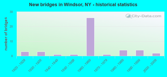
- New bridges - historical statistics
- 31920-1929
- 31930-1939
- 11940-1949
- 11950-1959
- 261960-1969
- 11970-1979
- 41980-1989
- 41990-1999
- 22000-2009

- Reconstructed bridges - Historical Statistics
- 71980-1989
- 51990-1999
- 82000-2009
- 02010-2019
- 12020-2022


- Bridge Condition - Deck
- 4.0%Excellent
- 8.0%Very good
- 56.0%Good
- 28.0%Satisfactory
- 4.0%Fair

- Bridge Condition - Superstructure
- 24.0%Very good
- 48.0%Good
- 24.0%Satisfactory
- 4.0%Poor

- Bridge Condition - Substructure
- 16.0%Very good
- 28.0%Good
- 40.0%Satisfactory
- 16.0%Fair

- Bridge Condition - Channel
- 11.5%Very good
- 42.3%Good
- 30.8%Satisfactory
- 11.5%Fair
- 3.8%Poor

- Bridge Condition - Culverts
- 11.1%Very good
- 22.2%Good
- 22.2%Satisfactory
- 44.4%Fair
Find on map >> Show street view
Structure Number: 1013161, Location: 3.0 MI W JCT RTS 17 + 79 (Lat: 42.086264, Lng: -75.696878), Route carried "on" structure: Interstate 86, Year Built: 1961, Year Reconstructed: 2007, Status: Open, Structure Length: 5.94m (19.49ft), Average Daily Traffic: 6,221 (year 2009), Truck Traffic: 18%, Design Load: HS 20, Features Intersected: CR 28
Minimum Vertical Clearance: 30+ m (98+ ft), Kilometerpoint: 36.894, Lanes on structure: 2, Lanes under structure: 2, Base Highway Network: Yes, Owner: State Highway Agency, Approaching Roadway Width: 10.1m (33.1ft), Skew: 4 degrees, Material/Design: Steel, Design/Construction: Stringer/Multi-beam, Number Of Spans In Main Unit: 3, Length of Maximum Span: 22.5m (73.8ft), Curb-To-Curb Width: 9.8m (32.2ft), Out-to-Out Width: 10.7m (35.1ft)
Condition: Deck: Satisfactory, Superstructure: Good, Substructure: Satisfactory, Operating Rating: 53.8 metric tons, Method Used To Determine Operating Rating: Load and Resistance Factor Rating (LRFR) rating reported by rating factor(RF) method using HL-93 loadings, Inventory Rating: 41.5 metric tons, Method Used To Determine Inventory Rating: Load and Resistance Factor Rating (LRFR) rating reported by rating factor(RF) method using HL-93 loadings, Structural Evaluation: Equal to present minimum criteria, Deck Geometry: High priority of replacement, Underclear: Meets minimum limits, Approach Roadway Alignment: Equal to present desirable criteria, Length Of Structure Improvement: 5.94m (19.49ft), Designated Inspection Frequency: Every 24 months, Inspection Date: June 2021, Bridge Improvement Cost: $1,463,000, Roadway Improvement Cost: $856,000, Total Project Cost: $2,319,000 ( Estimate for 2021), Deck Structure Type: Concrete Cast-file-Place, Wearing Surface/Protective System: Wearing Surface: Integral Concrete, Deck Protection: Epoxy Coated Reinforcing
Find on map >> Show street view
Structure Number: 1013162, Location: 3.0 MI W JCT RTS 17 + 79 (Lat: 42.085908, Lng: -75.696508), Route carried "on" structure: Interstate 86, Year Built: 1961, Year Reconstructed: 2007, Status: Open, Structure Length: 6.04m (19.82ft), Average Daily Traffic: 4,403 (year 2019), Truck Traffic: 17%, Average Future Daily Traffic: 5,244 (year 2040), Design Load: HS 20, Features Intersected: CR 28
Minimum Vertical Clearance: 30+ m (98+ ft), Kilometerpoint: 36.830, Lanes on structure: 2, Lanes under structure: 2, Base Highway Network: Yes, Owner: State Highway Agency, Approaching Roadway Width: 11.6m (38.1ft), Skew: 4 degrees, Material/Design: Steel, Design/Construction: Stringer/Multi-beam, Number Of Spans In Main Unit: 3, Length of Maximum Span: 22.5m (73.8ft), Curb-To-Curb Width: 8.5m (27.9ft), Out-to-Out Width: 10.1m (33.1ft)
Condition: Deck: Satisfactory, Superstructure: Good, Substructure: Satisfactory, Operating Rating: 50.5 metric tons, Method Used To Determine Operating Rating: Load and Resistance Factor Rating (LRFR) rating reported by rating factor(RF) method using HL-93 loadings, Inventory Rating: 38.9 metric tons, Method Used To Determine Inventory Rating: Load and Resistance Factor Rating (LRFR) rating reported by rating factor(RF) method using HL-93 loadings, Structural Evaluation: Equal to present minimum criteria, Deck Geometry: High priority of corrective action, Underclear: Meets minimum limits, Approach Roadway Alignment: Equal to present desirable criteria, Length Of Structure Improvement: 6.03m (19.78ft), Designated Inspection Frequency: Every 24 months, Inspection Date: June 2021, Bridge Improvement Cost: $1,398,000, Roadway Improvement Cost: $819,000, Total Project Cost: $2,216,000 ( Estimate for 2021), Deck Structure Type: Concrete Cast-file-Place, Wearing Surface/Protective System: Wearing Surface: Monolithic Concrete
Find on map >> Show street view
Structure Number: 1013171, Location: 1.9 MI W JCT SH17 & SH79 (Lat: 42.083744, Lng: -75.676169), Route carried "on" structure: Interstate 86, Year Built: 1961, Year Reconstructed: 2007, Status: Open, Structure Length: 4.45m (14.60ft), Average Daily Traffic: 5,291 (year 2009), Truck Traffic: 17%, Design Load: HS 20, Features Intersected: SHEDD ROAD
Minimum Vertical Clearance: 30+ m (98+ ft), Kilometerpoint: 38.616, Lanes on structure: 2, Lanes under structure: 2, Base Highway Network: Yes, Owner: State Highway Agency, Approaching Roadway Width: 9.4m (30.8ft), Skew: 1 degrees, Material/Design: Steel, Design/Construction: Stringer/Multi-beam, Number Of Spans In Main Unit: 3, Length of Maximum Span: 15.5m (50.9ft), Curb-To-Curb Width: 9.0m (29.5ft), Out-to-Out Width: 10.1m (33.1ft)
Condition: Deck: Fair, Superstructure: Satisfactory, Substructure: Fair, Operating Rating: 38.6 metric tons, Method Used To Determine Operating Rating: Load and Resistance Factor Rating (LRFR) rating reported by rating factor(RF) method using HL-93 loadings, Inventory Rating: 29.8 metric tons, Method Used To Determine Inventory Rating: Load and Resistance Factor Rating (LRFR) rating reported by rating factor(RF) method using HL-93 loadings, Structural Evaluation: Somewhat better than minimum adequacy, Deck Geometry: High priority of replacement, Underclear: High priority of corrective action, Approach Roadway Alignment: Equal to present desirable criteria, Length Of Structure Improvement: 4.45m (14.60ft), Designated Inspection Frequency: Every 24 months, Inspection Date: May 2021, Bridge Improvement Cost: $1,068,000, Roadway Improvement Cost: $625,000, Total Project Cost: $1,693,000 ( Estimate for 2021), Deck Structure Type: Concrete Cast-file-Place, Wearing Surface/Protective System: Wearing Surface: Monolithic Concrete
Find on map >> Show street view
Structure Number: 1013172, Location: 1.9 MI W JCT SH17 & SH79 (Lat: 42.083042, Lng: -75.676228), Route carried "on" structure: Interstate 86, Year Built: 1961, Year Reconstructed: 2007, Status: Open, Structure Length: 4.69m (15.39ft), Average Daily Traffic: 3,976 (year 2019), Truck Traffic: 17%, Average Future Daily Traffic: 4,735 (year 2040), Design Load: HS 20, Features Intersected: SHEDD ROAD
Minimum Vertical Clearance: 30+ m (98+ ft), Kilometerpoint: 38.552, Lanes on structure: 2, Lanes under structure: 2, Base Highway Network: Yes, Owner: State Highway Agency, Approaching Roadway Width: 12.2m (40.0ft), Material/Design: Steel, Design/Construction: Stringer/Multi-beam, Number Of Spans In Main Unit: 3, Length of Maximum Span: 15.8m (51.8ft), Curb-To-Curb Width: 9.1m (29.9ft), Out-to-Out Width: 10.2m (33.5ft)
Condition: Deck: Satisfactory, Superstructure: Satisfactory, Substructure: Fair, Operating Rating: 39.9 metric tons, Method Used To Determine Operating Rating: Load and Resistance Factor Rating (LRFR) rating reported by rating factor(RF) method using HL-93 loadings, Inventory Rating: 30.8 metric tons, Method Used To Determine Inventory Rating: Load and Resistance Factor Rating (LRFR) rating reported by rating factor(RF) method using HL-93 loadings, Structural Evaluation: Somewhat better than minimum adequacy, Deck Geometry: High priority of replacement, Underclear: High priority of corrective action, Approach Roadway Alignment: Equal to present desirable criteria, Length Of Structure Improvement: 4.69m (15.39ft), Designated Inspection Frequency: Every 24 months, Inspection Date: May 2021, Bridge Improvement Cost: $1,122,000, Roadway Improvement Cost: $657,000, Total Project Cost: $1,779,000 ( Estimate for 2021), Deck Structure Type: Concrete Cast-file-Place, Wearing Surface/Protective System: Wearing Surface: Monolithic Concrete
Find on map >> Show street view
Structure Number: 1013181, Location: 1.3MI W JCT RTS 17 & 79 (Lat: 42.078281, Lng: -75.664478), Route carried "on" structure: Interstate 86, Year Built: 1961, Year Reconstructed: 1997, Status: Open, Structure Length: 13.17m (43.21ft), Average Daily Traffic: 5,291 (year 2009), Truck Traffic: 17%, Design Load: HS 20+Mod, Features Intersected: CR 28, OCCANUM CREEK
Minimum Vertical Clearance: 30+ m (98+ ft), Kilometerpoint: 39.646, Lanes on structure: 2, Lanes under structure: 2, Base Highway Network: Yes, Owner: State Highway Agency, Approaching Roadway Width: 11.6m (38.1ft), Skew: 5 degrees, Material/Design: Steel, Design/Construction: Stringer/Multi-beam, Number Of Spans In Main Unit: 4, Length of Maximum Span: 36.2m (118.8ft), Curb-To-Curb Width: 9.1m (29.9ft), Out-to-Out Width: 10.1m (33.1ft)
Condition: Deck: Good, Superstructure: Good, Substructure: Good, Channel: Very good, Operating Rating: 92.5 metric tons, Method Used To Determine Operating Rating: Load Factor (LF), Inventory Rating: 55.3 metric tons, Method Used To Determine Inventory Rating: Load Factor (LF), Structural Evaluation: Better than present minimum criteria, Deck Geometry: Meets minimum limits, Underclear: Meets minimum limits, Waterway Adequacy: Equal to present minimum criteria, Approach Roadway Alignment: Equal to present desirable criteria, Length Of Structure Improvement: 13.16m (43.18ft), Designated Inspection Frequency: Every 24 months, Inspection Date: August 2021, Bridge Improvement Cost: $3,043,000, Roadway Improvement Cost: $1,782,000, Total Project Cost: $4,824,000 ( Estimate for 2021), Deck Structure Type: Concrete Cast-file-Place, Wearing Surface/Protective System: Wearing Surface: Monolithic Concrete
Find on map >> Show street view
Structure Number: 1013182, Location: 1.3MI W JCT RTS 17 & 79 (Lat: 42.078267, Lng: -75.665469), Route carried "on" structure: Interstate 86, Year Built: 1961, Year Reconstructed: 1997, Status: Open, Structure Length: 15.91m (52.20ft), Average Daily Traffic: 3,976 (year 2019), Truck Traffic: 17%, Average Future Daily Traffic: 4,735 (year 2040), Design Load: HS 20+Mod, Features Intersected: CR 28, OCCANUM CREEK
Minimum Vertical Clearance: 30+ m (98+ ft), Kilometerpoint: 39.646, Lanes on structure: 2, Lanes under structure: 2, Base Highway Network: Yes, Owner: State Highway Agency, Approaching Roadway Width: 11.6m (38.1ft), Skew: 5 degrees, Material/Design: Steel, Design/Construction: Stringer/Multi-beam, Number Of Spans In Main Unit: 5, Length of Maximum Span: 35.9m (117.8ft), Curb-To-Curb Width: 9.8m (32.2ft), Out-to-Out Width: 10.7m (35.1ft)
Condition: Deck: Good, Superstructure: Good, Substructure: Good, Channel: Very good, Operating Rating: 92.5 metric tons, Method Used To Determine Operating Rating: Load Factor (LF), Inventory Rating: 55.3 metric tons, Method Used To Determine Inventory Rating: Load Factor (LF), Structural Evaluation: Better than present minimum criteria, Deck Geometry: Meets minimum limits, Underclear: Meets minimum limits, Waterway Adequacy: Equal to present minimum criteria, Approach Roadway Alignment: Equal to present desirable criteria, Length Of Structure Improvement: 15.91m (52.20ft), Designated Inspection Frequency: Every 24 months, Inspection Date: August 2021, Bridge Improvement Cost: $3,834,000, Roadway Improvement Cost: $2,245,000, Total Project Cost: $6,080,000 ( Estimate for 2021), Deck Structure Type: Concrete Cast-file-Place, Wearing Surface/Protective System: Wearing Surface: Monolithic Concrete
Find on map >> Show street view
Structure Number: 1013191, Location: JCT RTS 17 + 79 (Lat: 42.072658, Lng: -75.641283), Route carried "on" structure: Interstate 86, Year Built: 1960, Year Reconstructed: 2005, Status: Open, Structure Length: 3.90m (12.80ft), Average Daily Traffic: 5,329 (year 2014), Truck Traffic: 17%, Average Future Daily Traffic: 7,460 (year 2034), Design Load: HS 20, Features Intersected: RTE 79
Minimum Vertical Clearance: 30+ m (98+ ft), Kilometerpoint: 41.770, Lanes on structure: 2, Lanes under structure: 2, Base Highway Network: Yes, Owner: State Highway Agency, Approaching Roadway Width: 10.4m (34.1ft), Skew: 1 degrees, Material/Design: Steel, Design/Construction: Stringer/Multi-beam, Number Of Spans In Main Unit: 3, Length of Maximum Span: 14.6m (47.9ft), Curb-To-Curb Width: 10.2m (33.5ft), Out-to-Out Width: 11.2m (36.7ft)
Condition: Deck: Good, Superstructure: Satisfactory, Substructure: Satisfactory, Operating Rating: 88.0 metric tons, Method Used To Determine Operating Rating: Load Factor (LF), Inventory Rating: 52.6 metric tons, Method Used To Determine Inventory Rating: Load Factor (LF), Structural Evaluation: Equal to present minimum criteria, Deck Geometry: Somewhat better than minimum adequacy, Underclear: Meets minimum limits, Approach Roadway Alignment: Equal to present desirable criteria, Length Of Structure Improvement: 3.90m (12.80ft), Designated Inspection Frequency: Every 24 months, Inspection Date: April 2020, Bridge Improvement Cost: $998,000, Roadway Improvement Cost: $584,000, Total Project Cost: $1,582,000 ( Estimate for 2021), Deck Structure Type: Concrete Cast-file-Place, Wearing Surface/Protective System: Wearing Surface: Integral Concrete, Deck Protection: Epoxy Coated Reinforcing
Find on map >> Show street view
Structure Number: 1013192, Location: JCT RTS 17 + 79 (Lat: 42.072411, Lng: -75.641331), Route carried "on" structure: Interstate 86, Year Built: 1960, Year Reconstructed: 2005, Status: Open, Structure Length: 4.05m (13.29ft), Average Daily Traffic: 3,976 (year 2019), Truck Traffic: 17%, Average Future Daily Traffic: 5,946 (year 2040), Design Load: HS 20, Features Intersected: RTE 79
Minimum Vertical Clearance: 30+ m (98+ ft), Kilometerpoint: 41.673, Lanes on structure: 2, Lanes under structure: 2, Base Highway Network: Yes, Owner: State Highway Agency, Approaching Roadway Width: 14.0m (45.9ft), Skew: 1 degrees, Material/Design: Steel, Design/Construction: Stringer/Multi-beam, Number Of Spans In Main Unit: 3, Length of Maximum Span: 14.6m (47.9ft), Curb-To-Curb Width: 13.9m (45.6ft), Out-to-Out Width: 14.8m (48.6ft)
Condition: Deck: Good, Superstructure: Satisfactory, Substructure: Good, Operating Rating: 88.0 metric tons, Method Used To Determine Operating Rating: Load Factor (LF), Inventory Rating: 52.6 metric tons, Method Used To Determine Inventory Rating: Load Factor (LF), Structural Evaluation: Equal to present minimum criteria, Deck Geometry: Superior to present desirable criteria, Underclear: Meets minimum limits, Approach Roadway Alignment: Equal to present desirable criteria, Length Of Structure Improvement: 4.05m (13.29ft), Designated Inspection Frequency: Every 24 months, Inspection Date: April 2020, Bridge Improvement Cost: $1,370,000, Roadway Improvement Cost: $802,000, Total Project Cost: $2,172,000 ( Estimate for 2021), Deck Structure Type: Concrete Cast-file-Place, Wearing Surface/Protective System: Wearing Surface: Integral Concrete, Deck Protection: Epoxy Coated Reinforcing
Find on map >> Show street view
Structure Number: 1013201, Location: 0.2 MI E JCT RTS 17 + 79 (Lat: 42.071800, Lng: -75.637842), Route carried "on" structure: State highway 17, Year Built: 1960, Year Reconstructed: 1988, Status: Open, Structure Length: 16.76m (54.99ft), Average Daily Traffic: 5,329 (year 2014), Truck Traffic: 15%, Design Load: HS 20, Features Intersected: SUSQUEHANNA RIVER
Minimum Vertical Clearance: 30+ m (98+ ft), Kilometerpoint: 41.947, Lanes on structure: 2, Base Highway Network: Yes, Owner: State Highway Agency, Approaching Roadway Width: 11.6m (38.1ft), Material/Design: Steel continuous, Design/Construction: Stringer/Multi-beam, Number Of Spans In Main Unit: 5, Length of Maximum Span: 38.1m (125.0ft), Curb-To-Curb Width: 10.5m (34.4ft), Out-to-Out Width: 11.2m (36.7ft)
Condition: Deck: Good, Superstructure: Very good, Substructure: Good, Channel: Good, Operating Rating: 65.3 metric tons, Method Used To Determine Operating Rating: Load Factor (LF), Inventory Rating: 39.0 metric tons, Method Used To Determine Inventory Rating: Load Factor (LF), Structural Evaluation: Better than present minimum criteria, Deck Geometry: Somewhat better than minimum adequacy, Waterway Adequacy: Equal to present minimum criteria, Approach Roadway Alignment: Equal to present desirable criteria, Length Of Structure Improvement: 16.76m (54.99ft), Designated Inspection Frequency: Every 24 months, Underwater Inspection Frequency: Every 60 months, Inspection Date: August 2020, Underwater Inspection Date: October 2017, Bridge Improvement Cost: $3,889,000, Roadway Improvement Cost: $2,277,000, Total Project Cost: $6,167,000 ( Estimate for 2021), Deck Structure Type: Concrete Cast-file-Place, Wearing Surface/Protective System: Wearing Surface: Integral Concrete, Deck Protection: Epoxy Coated Reinforcing
Find on map >> Show street view
Structure Number: 1013202, Location: 0.2 MI E JCT RTS 17 + 79 (Lat: 42.071550, Lng: -75.637767), Route carried "on" structure: State highway 17, Year Built: 1960, Year Reconstructed: 1988, Status: Open, Structure Length: 16.76m (54.99ft), Average Daily Traffic: 3,811 (year 2018), Truck Traffic: 16%, Average Future Daily Traffic: 5,946 (year 2040), Design Load: HS 20, Features Intersected: SUSQUEHANNA RIVER
Minimum Vertical Clearance: 30+ m (98+ ft), Kilometerpoint: 41.947, Lanes on structure: 2, Base Highway Network: Yes, Owner: State Highway Agency, Approaching Roadway Width: 11.6m (38.1ft), Material/Design: Steel continuous, Design/Construction: Stringer/Multi-beam, Number Of Spans In Main Unit: 5, Length of Maximum Span: 38.1m (125.0ft), Curb-To-Curb Width: 10.5m (34.4ft), Out-to-Out Width: 11.2m (36.7ft)
Condition: Deck: Satisfactory, Superstructure: Very good, Substructure: Good, Channel: Good, Operating Rating: 65.3 metric tons, Method Used To Determine Operating Rating: Load Factor (LF), Inventory Rating: 39.0 metric tons, Method Used To Determine Inventory Rating: Load Factor (LF), Structural Evaluation: Better than present minimum criteria, Deck Geometry: Somewhat better than minimum adequacy, Waterway Adequacy: Equal to present minimum criteria, Approach Roadway Alignment: Equal to present desirable criteria, Length Of Structure Improvement: 16.76m (54.99ft), Designated Inspection Frequency: Every 24 months, Underwater Inspection Frequency: Every 60 months, Inspection Date: August 2020, Underwater Inspection Date: October 2017, Bridge Improvement Cost: $3,889,000, Roadway Improvement Cost: $2,277,000, Total Project Cost: $6,167,000 ( Estimate for 2021), Deck Structure Type: Concrete Cast-file-Place, Wearing Surface/Protective System: Wearing Surface: Integral Concrete, Deck Protection: Epoxy Coated Reinforcing
Find on map >> Show street view
Structure Number: 1013221, Location: 2.0 MI SE JCT RTS 17 + 79 (Lat: 42.054550, Lng: -75.613692), Route carried "on" structure: State highway 17, Year Built: 1960, Year Reconstructed: 1991, Status: Open, Structure Length: 4.36m (14.30ft), Average Daily Traffic: 5,329 (year 2014), Truck Traffic: 15%, Design Load: HS 20, Features Intersected: TUSCARORA CREEK
Minimum Vertical Clearance: 30+ m (98+ ft), Kilometerpoint: 44.875, Lanes on structure: 3, Base Highway Network: Yes, Owner: State Highway Agency, Approaching Roadway Width: 14.6m (47.9ft), Material/Design: Steel, Design/Construction: Stringer/Multi-beam, Number Of Spans In Main Unit: 3, Length of Maximum Span: 17.9m (58.7ft), Curb-To-Curb Width: 13.8m (45.3ft), Out-to-Out Width: 14.4m (47.2ft)
Condition: Deck: Good, Superstructure: Good, Substructure: Satisfactory, Channel: Satisfactory, Operating Rating: 90.1 metric tons, Method Used To Determine Operating Rating: Load and Resistance Factor Rating (LRFR) rating reported by rating factor(RF) method using HL-93 loadings, Inventory Rating: 69.3 metric tons, Method Used To Determine Inventory Rating: Load and Resistance Factor Rating (LRFR) rating reported by rating factor(RF) method using HL-93 loadings, Structural Evaluation: Equal to present minimum criteria, Deck Geometry: Somewhat better than minimum adequacy, Waterway Adequacy: Somewhat better than minimum adequacy, Approach Roadway Alignment: Equal to present desirable criteria, Length Of Structure Improvement: 4.35m (14.27ft), Designated Inspection Frequency: Every 24 months, Inspection Date: September 2021, Bridge Improvement Cost: $1,467,000, Roadway Improvement Cost: $859,000, Total Project Cost: $2,325,000 ( Estimate for 2021), Deck Structure Type: Concrete Cast-file-Place, Wearing Surface/Protective System: Wearing Surface: Integral Concrete, Deck Protection: Epoxy Coated Reinforcing
Find on map >> Show street view
Structure Number: 1013222, Location: 2.0 MI SE JCT RTS 17 + 79 (Lat: 42.054328, Lng: -75.613758), Route carried "on" structure: State highway 17, Year Built: 1960, Year Reconstructed: 1991, Status: Open, Structure Length: 5.24m (17.19ft), Average Daily Traffic: 3,811 (year 2018), Truck Traffic: 16%, Average Future Daily Traffic: 5,946 (year 2040), Design Load: HS 20, Features Intersected: TUSCARORA CREEK
Minimum Vertical Clearance: 30+ m (98+ ft), Kilometerpoint: 44.875, Lanes on structure: 3, Base Highway Network: Yes, Owner: State Highway Agency, Approaching Roadway Width: 15.8m (51.8ft), Material/Design: Steel, Design/Construction: Stringer/Multi-beam, Number Of Spans In Main Unit: 3, Length of Maximum Span: 18.5m (60.7ft), Curb-To-Curb Width: 13.8m (45.3ft), Out-to-Out Width: 14.4m (47.2ft)
Condition: Deck: Good, Superstructure: Good, Substructure: Satisfactory, Channel: Satisfactory, Operating Rating: 80.0 metric tons, Method Used To Determine Operating Rating: Load and Resistance Factor Rating (LRFR) rating reported by rating factor(RF) method using HL-93 loadings, Inventory Rating: 61.6 metric tons, Method Used To Determine Inventory Rating: Load and Resistance Factor Rating (LRFR) rating reported by rating factor(RF) method using HL-93 loadings, Structural Evaluation: Equal to present minimum criteria, Deck Geometry: Somewhat better than minimum adequacy, Waterway Adequacy: Equal to present minimum criteria, Approach Roadway Alignment: Equal to present desirable criteria, Length Of Structure Improvement: 5.24m (17.19ft), Designated Inspection Frequency: Every 24 months, Inspection Date: September 2021, Bridge Improvement Cost: $1,718,000, Roadway Improvement Cost: $1,006,000, Total Project Cost: $2,724,000 ( Estimate for 2021), Deck Structure Type: Concrete Cast-file-Place, Wearing Surface/Protective System: Wearing Surface: Integral Concrete, Deck Protection: Epoxy Coated Reinforcing
Find on map >> Show street view
Structure Number: 1013231, Location: 2.1 MI SE JCT RTS 17 + 79 (Lat: 42.054444, Lng: -75.610475), Route carried "on" structure: State highway 17, Year Built: 1960, Year Reconstructed: 1991, Status: Open, Structure Length: 4.15m (13.62ft), Average Daily Traffic: 3,827 (year 2009), Truck Traffic: 24%, Design Load: HS 20, Features Intersected: CR 225
Minimum Vertical Clearance: 30+ m (98+ ft), Kilometerpoint: 45.149, Lanes on structure: 2, Lanes under structure: 2, Base Highway Network: Yes, Owner: State Highway Agency, Approaching Roadway Width: 11.0m (36.1ft), Skew: 1 degrees, Material/Design: Steel, Design/Construction: Stringer/Multi-beam, Number Of Spans In Main Unit: 3, Length of Maximum Span: 14.6m (47.9ft), Curb-To-Curb Width: 10.2m (33.5ft), Out-to-Out Width: 11.2m (36.7ft)
Condition: Deck: Satisfactory, Superstructure: Satisfactory, Substructure: Satisfactory, Operating Rating: 49.6 metric tons, Method Used To Determine Operating Rating: Load and Resistance Factor Rating (LRFR) rating reported by rating factor(RF) method using HL-93 loadings, Inventory Rating: 38.2 metric tons, Method Used To Determine Inventory Rating: Load and Resistance Factor Rating (LRFR) rating reported by rating factor(RF) method using HL-93 loadings, Structural Evaluation: Equal to present minimum criteria, Deck Geometry: Somewhat better than minimum adequacy, Underclear: Equal to present minimum criteria, Approach Roadway Alignment: Equal to present desirable criteria, Length Of Structure Improvement: 4.14m (13.58ft), Designated Inspection Frequency: Every 24 months, Inspection Date: May 2021, Bridge Improvement Cost: $1,084,000, Roadway Improvement Cost: $635,000, Total Project Cost: $1,719,000 ( Estimate for 2021), Deck Structure Type: Concrete Cast-file-Place, Wearing Surface/Protective System: Wearing Surface: Integral Concrete, Deck Protection: Epoxy Coated Reinforcing
Find on map >> Show street view
Structure Number: 1013232, Location: 2.1 MI SE JCT RTS 17 + 79 (Lat: 42.054217, Lng: -75.610522), Route carried "on" structure: State highway 17, Year Built: 1960, Year Reconstructed: 2007, Status: Open, Structure Length: 4.36m (14.30ft), Average Daily Traffic: 3,134 (year 2009), Truck Traffic: 24%, Average Future Daily Traffic: 4,890 (year 2040), Design Load: HS 20, Features Intersected: CR 225
Minimum Vertical Clearance: 30+ m (98+ ft), Kilometerpoint: 45.149, Lanes on structure: 3, Lanes under structure: 2, Base Highway Network: Yes, Owner: State Highway Agency, Approaching Roadway Width: 14.0m (45.9ft), Skew: 1 degrees, Material/Design: Steel, Design/Construction: Stringer/Multi-beam, Number Of Spans In Main Unit: 3, Length of Maximum Span: 15.2m (49.9ft), Curb-To-Curb Width: 13.5m (44.3ft), Out-to-Out Width: 14.4m (47.2ft)
Condition: Deck: Satisfactory, Superstructure: Satisfactory, Substructure: Satisfactory, Operating Rating: 88.9 metric tons, Method Used To Determine Operating Rating: Load Factor (LF), Inventory Rating: 52.6 metric tons, Method Used To Determine Inventory Rating: Load Factor (LF), Structural Evaluation: Equal to present minimum criteria, Deck Geometry: Somewhat better than minimum adequacy, Underclear: Equal to present minimum criteria, Approach Roadway Alignment: Equal to present desirable criteria, Length Of Structure Improvement: 4.35m (14.27ft), Designated Inspection Frequency: Every 24 months, Inspection Date: May 2021, Bridge Improvement Cost: $1,458,000, Roadway Improvement Cost: $854,000, Total Project Cost: $2,313,000 ( Estimate for 2021), Deck Structure Type: Concrete Cast-file-Place, Wearing Surface/Protective System: Wearing Surface: Integral Concrete, Deck Protection: Epoxy Coated Reinforcing
Find on map >> Show street view
Structure Number: 10304, Location: .2 MI S JCT SH 79 & SH 17 (Lat: 42.069533, Lng: -75.641211), Route carried "on" structure: State highway 79, Year Built: 1996, Status: Open, Structure Length: 0.76m (2.49ft), Average Daily Traffic: 705 (year 2019), Truck Traffic: 8%, Average Future Daily Traffic: 735 (year 2040), Design Load: HS 25 or greater, Features Intersected: SANFORD CREEK
Minimum Vertical Clearance: 30+ m (98+ ft), Kilometerpoint: 9.525, Lanes on structure: 2, Base Highway Network: Yes, Owner: State Highway Agency, Approaching Roadway Width: 9.4m (30.8ft), Material/Design: Concrete, Design/Construction: Frame, Number Of Spans In Main Unit: 1, Length of Maximum Span: 7.3m (24.0ft), Curb or Sidewalk Widths: Left: 1.7m (5.6ft), Right: 0.0m, Curb-To-Curb Width: 9.6m (31.5ft), Out-to-Out Width: 11.9m (39.0ft)
Condition: Deck: Good, Superstructure: Good, Substructure: Good, Channel: Satisfactory, Operating Rating: 68.9 metric tons, Method Used To Determine Operating Rating: Load Factor (LF), Inventory Rating: 40.8 metric tons, Method Used To Determine Inventory Rating: Load Factor (LF), Structural Evaluation: Better than present minimum criteria, Deck Geometry: Equal to present minimum criteria, Waterway Adequacy: Meets minimum limits, Approach Roadway Alignment: Equal to present desirable criteria, Length Of Structure Improvement: 0.76m (2.49ft), Designated Inspection Frequency: Every 24 months, Inspection Date: July 2020, Bridge Improvement Cost: $366,000, Roadway Improvement Cost: $214,000, Total Project Cost: $580,000 ( Estimate for 2021)
Find on map >> Show street view
Structure Number: 103041, Location: .6 MI N JCT SH 79 & SH 17 (Lat: 42.081500, Lng: -75.639503), Route carried "on" structure: State highway 79, Year Built: 1948, Year Reconstructed: 1988, Status: Open, Structure Length: 2.53m (8.30ft), Average Daily Traffic: 1,989 (year 2020), Truck Traffic: 9%, Average Future Daily Traffic: 2,074 (year 2040), Design Load: HS 20, Features Intersected: OCCANUM CREEK
Minimum Vertical Clearance: 30+ m (98+ ft), Kilometerpoint: 10.861, Lanes on structure: 2, Base Highway Network: Yes, Owner: State Highway Agency, Approaching Roadway Width: 10.4m (34.1ft), Skew: 6 degrees, Material/Design: Steel, Design/Construction: Stringer/Multi-beam, Number Of Spans In Main Unit: 1, Length of Maximum Span: 22.8m (74.8ft), Curb or Sidewalk Widths: Left: 1.5m (4.9ft), Right: 1.5m (4.9ft), Curb-To-Curb Width: 10.4m (34.1ft), Out-to-Out Width: 14.0m (45.9ft)
Condition: Deck: Good, Superstructure: Good, Substructure: Fair, Channel: Fair, Operating Rating: 63.5 metric tons, Method Used To Determine Operating Rating: Load Factor (LF), Inventory Rating: 38.1 metric tons, Method Used To Determine Inventory Rating: Load Factor (LF), Structural Evaluation: Somewhat better than minimum adequacy, Deck Geometry: Equal to present minimum criteria, Waterway Adequacy: Equal to present desirable criteria, Approach Roadway Alignment: Equal to present desirable criteria, Length Of Structure Improvement: 2.52m (8.27ft), Designated Inspection Frequency: Every 24 months, Inspection Date: March 2020, Bridge Improvement Cost: $1,540,000, Roadway Improvement Cost: $902,000, Total Project Cost: $2,442,000 ( Estimate for 2021), Deck Structure Type: Concrete Cast-file-Place, Wearing Surface/Protective System: Wearing Surface: Integral Concrete, Deck Protection: Epoxy Coated Reinforcing
Find on map >> Show street view
Structure Number: 103042, Location: 3.3 MI N JCT SH 79 & SH17 (Lat: 42.116589, Lng: -75.656069), Route carried "on" structure: State highway 79, Year Built: 1996, Status: Open, Structure Length: 3.38m (11.09ft), Average Daily Traffic: 1,989 (year 2020), Truck Traffic: 9%, Average Future Daily Traffic: 2,074 (year 2040), Design Load: HS 25 or greater, Features Intersected: SAGE CREEK
Minimum Vertical Clearance: 30+ m (98+ ft), Kilometerpoint: 15.189, Lanes on structure: 2, Base Highway Network: Yes, Owner: State Highway Agency, Approaching Roadway Width: 10.3m (33.8ft), Skew: 4 degrees, Material/Design: Steel, Design/Construction: Stringer/Multi-beam, Number Of Spans In Main Unit: 1, Length of Maximum Span: 32.0m (105.0ft), Curb-To-Curb Width: 10.4m (34.1ft), Out-to-Out Width: 11.0m (36.1ft)
Condition: Deck: Good, Superstructure: Good, Substructure: Very good, Channel: Very good, Operating Rating: 62.6 metric tons, Method Used To Determine Operating Rating: Load Factor (LF), Inventory Rating: 37.2 metric tons, Method Used To Determine Inventory Rating: Load Factor (LF), Structural Evaluation: Better than present minimum criteria, Deck Geometry: Equal to present minimum criteria, Waterway Adequacy: Equal to present desirable criteria, Approach Roadway Alignment: Equal to present desirable criteria, Length Of Structure Improvement: 3.38m (11.09ft), Designated Inspection Frequency: Every 24 months, Inspection Date: June 2020, Bridge Improvement Cost: $1,142,000, Roadway Improvement Cost: $669,000, Total Project Cost: $1,810,000 ( Estimate for 2021), Deck Structure Type: Concrete Cast-file-Place, Wearing Surface/Protective System: Wearing Surface: Integral Concrete, Deck Protection: Epoxy Coated Reinforcing
Find on map >> Show street view
Structure Number: 106315, Location: 3.3 MI W JCT SH 17 & SH79 (Lat: 42.086606, Lng: -75.701633), Route carried "on" structure: Interstate 86, Year Built: 1960, Status: Open, Structure Length: 0.76m (2.49ft), Average Daily Traffic: 8,806 (year 2019), Truck Traffic: 16%, Average Future Daily Traffic: 10,487 (year 2040), Design Load: H 20, Features Intersected: NORTH OCCANUM CRE
Minimum Vertical Clearance: 30+ m (98+ ft), Kilometerpoint: 36.428, Lanes on structure: 4, Base Highway Network: Yes, Owner: State Highway Agency, Approaching Roadway Width: 24.4m (80.1ft), Skew: 22 degrees, Material/Design: Concrete, Design/Construction: Culvert, Number Of Spans In Main Unit: 1, Length of Maximum Span: 7.3m (24.0ft)
Condition: Channel: Satisfactory, Culverts: Satisfactory, Operating Rating: 85.3 metric tons, Method Used To Determine Operating Rating: Load Factor (LF), Inventory Rating: 50.8 metric tons, Method Used To Determine Inventory Rating: Load Factor (LF), Structural Evaluation: Equal to present minimum criteria, Waterway Adequacy: High priority of corrective action, Approach Roadway Alignment: Equal to present desirable criteria, Length Of Structure Improvement: 0.76m (2.49ft), Designated Inspection Frequency: Every 24 months, Inspection Date: July 2020, Bridge Improvement Cost: $1,225,000, Roadway Improvement Cost: $717,000, Total Project Cost: $1,942,000 ( Estimate for 2021)
Find on map >> Show street view
Structure Number: 109451, Location: 3.8 MI S JCT RTS 79 & 17 (Lat: 42.027494, Lng: -75.622231), Route carried "on" structure: State highway 79, Year Built: 1993, Status: Open, Structure Length: 1.89m (6.20ft), Average Daily Traffic: 580 (year 2020), Truck Traffic: 10%, Average Future Daily Traffic: 605 (year 2040), Design Load: HS 20, Features Intersected: UNKNOWN CREEK
Minimum Vertical Clearance: 30+ m (98+ ft), Kilometerpoint: 3.765, Lanes on structure: 2, Base Highway Network: Yes, Owner: State Highway Agency, Approaching Roadway Width: 7.9m (25.9ft), Skew: 2 degrees, Material/Design: Prestressed concrete, Design/Construction: Box Beam or Girders - Multiple, Number Of Spans In Main Unit: 1, Length of Maximum Span: 17.3m (56.8ft), Curb-To-Curb Width: 8.0m (26.2ft), Out-to-Out Width: 8.6m (28.2ft)
Condition: Deck: Satisfactory, Superstructure: Good, Substructure: Very good, Channel: Good, Operating Rating: 51.2 metric tons, Method Used To Determine Operating Rating: Load and Resistance Factor Rating (LRFR) rating reported by rating factor(RF) method using HL-93 loadings, Inventory Rating: 33.7 metric tons, Method Used To Determine Inventory Rating: Load and Resistance Factor Rating (LRFR) rating reported by rating factor(RF) method using HL-93 loadings, Structural Evaluation: Better than present minimum criteria, Deck Geometry: Somewhat better than minimum adequacy, Waterway Adequacy: Somewhat better than minimum adequacy, Approach Roadway Alignment: Equal to present desirable criteria, Length Of Structure Improvement: 1.88m (6.17ft), Designated Inspection Frequency: Every 24 months, Inspection Date: March 2021, Bridge Improvement Cost: $336,000, Roadway Improvement Cost: $197,000, Total Project Cost: $533,000 ( Estimate for 2021), Wearing Surface/Protective System: Wearing Surface: Monolithic Concrete
Find on map >> Show street view
Structure Number: 222602, Location: 1 MI SE OF OCCANUM (Lat: 42.080869, Lng: -75.691650), Route carried "on" structure: Other road , Year Built: 1977, Status: Open, Structure Length: 1.01m (3.31ft), Average Daily Traffic: 347 (year 2018), Truck Traffic: 5%, Average Future Daily Traffic: 486 (year 2038), Features Intersected: OCCANUM CREEK, Facility Carried by Structure: HOADLEY HILL ROAD
Minimum Vertical Clearance: 30+ m (98+ ft), Kilometerpoint: 4.119, Lanes on structure: 2, Owner: Town or Township Highway Agency, Approaching Roadway Width: 5.5m (18.0ft), Skew: 3 degrees, Material/Design: Steel, Design/Construction: Culvert, Number Of Spans In Main Unit: 1, Length of Maximum Span: 9.7m (31.8ft)
Condition: Channel: Fair, Culverts: Good, Operating Rating: 79.5 metric tons, Method Used To Determine Operating Rating: Field evaluation and documented engineering judgment, Inventory Rating: 32.7 metric tons, Method Used To Determine Inventory Rating: Field evaluation and documented engineering judgment, Structural Evaluation: Better than present minimum criteria, Waterway Adequacy: Equal to present desirable criteria, Approach Roadway Alignment: Equal to present desirable criteria, Length Of Structure Improvement: 1.00m (3.28ft), Designated Inspection Frequency: Every 24 months, Inspection Date: April 2020, Bridge Improvement Cost: $98,000, Roadway Improvement Cost: $57,000, Total Project Cost: $155,000 ( Estimate for 2021)
Find on map >> Show street view
Structure Number: 222606, Location: 0.3 MI E OF EDSON (Lat: 42.026922, Lng: -75.666725), Route carried "on" structure: Other road , Year Built: 1981, Year Reconstructed: 1990, Status: Open, Structure Length: 0.64m (2.10ft), Average Daily Traffic: 296 (year 2005), Truck Traffic: 5%, Average Future Daily Traffic: 414 (year 2025), Features Intersected: TRIB SUSQUE RIVER, Facility Carried by Structure: BARTON ROAD
Minimum Vertical Clearance: 30+ m (98+ ft), Kilometerpoint: 0.451, Lanes on structure: 2, Owner: Town or Township Highway Agency, Approaching Roadway Width: 6.1m (20.0ft), Skew: 1 degrees, Material/Design: Steel, Design/Construction: Culvert, Number Of Spans In Main Unit: 1, Length of Maximum Span: 6.0m (19.7ft)
Condition: Channel: Poor, Culverts: Fair, Operating Rating: 76.5 metric tons, Method Used To Determine Operating Rating: Field evaluation and documented engineering judgment, Inventory Rating: 29.4 metric tons, Method Used To Determine Inventory Rating: Field evaluation and documented engineering judgment, Structural Evaluation: Somewhat better than minimum adequacy, Waterway Adequacy: Meets minimum limits, Approach Roadway Alignment: Equal to present desirable criteria, Length Of Structure Improvement: 0.64m (2.10ft), Designated Inspection Frequency: Every 24 months, Inspection Date: June 2020, Bridge Improvement Cost: $69,000, Roadway Improvement Cost: $40,000, Total Project Cost: $109,000 ( Estimate for 2021)
Find on map >> Show street view
Structure Number: 222607, Location: HAMLET OF DAMASCUS (Lat: 42.054103, Lng: -75.613817), Route carried "on" structure: Other road , Year Built: 1964, Status: Posted for load, Structure Length: 3.35m (10.99ft), Average Daily Traffic: 66 (year 2016), Truck Traffic: 5%, Average Future Daily Traffic: 92 (year 2036), Features Intersected: TUSCARORA CREEK, Facility Carried by Structure: MCNAIR RD
Minimum Vertical Clearance: 30+ m (98+ ft), Kilometerpoint: 0.354, Lanes on structure: 2, Owner: Town or Township Highway Agency, Approaching Roadway Width: 6.7m (22.0ft), Material/Design: Steel, Design/Construction: Stringer/Multi-beam, Number Of Spans In Main Unit: 3, Length of Maximum Span: 13.1m (43.0ft), Curb or Sidewalk Widths: Left: 0.5m (1.6ft), Right: 0.5m (1.6ft), Curb-To-Curb Width: 6.8m (22.3ft), Out-to-Out Width: 8.3m (27.2ft)
Condition: Deck: Good, Superstructure: Poor, Substructure: Satisfactory, Channel: Satisfactory, Operating Rating: 10.0 metric tons, Method Used To Determine Operating Rating: Load Factor (LF), Inventory Rating: 5.4 metric tons, Method Used To Determine Inventory Rating: Load Factor (LF), Structural Evaluation: High priority of corrective action, Deck Geometry: Somewhat better than minimum adequacy, Waterway Adequacy: Meets minimum limits, Approach Roadway Alignment: Equal to present minimum criteria, Bridge Posting: Required (Relationship of Operating Rating to Maximum Legal Load: > 39.9% below), Length Of Structure Improvement: 3.35m (10.99ft), Designated Inspection Frequency: Every 12 months, Inspection Date: June 2021, Bridge Improvement Cost: $670,000, Roadway Improvement Cost: $392,000, Total Project Cost: $1,062,000 ( Estimate for 2021), Deck Structure Type: Concrete Cast-file-Place, Wearing Surface/Protective System: Wearing Surface: Bituminous
Find on map >> Show street view
Structure Number: 222611, Location: 1.0 MI S W OF OUAGUAGA (Lat: 42.117606, Lng: -75.663828), Route carried "on" structure: Other road , Year Built: 1981, Status: Open, Structure Length: 1.04m (3.41ft), Average Daily Traffic: 137 (year 2019), Truck Traffic: 5%, Average Future Daily Traffic: 192 (year 2039), Features Intersected: SAGE CREEK, Facility Carried by Structure: SEWARD ROAD
Minimum Vertical Clearance: 30+ m (98+ ft), Kilometerpoint: 0.805, Lanes on structure: 2, Owner: Town or Township Highway Agency, Approaching Roadway Width: 6.7m (22.0ft), Skew: 3 degrees, Material/Design: Steel, Design/Construction: Culvert, Number Of Spans In Main Unit: 1, Length of Maximum Span: 8.8m (28.9ft)
Condition: Channel: Satisfactory, Culverts: Fair, Operating Rating: 76.3 metric tons, Method Used To Determine Operating Rating: Field evaluation and documented engineering judgment, Inventory Rating: 19.6 metric tons, Method Used To Determine Inventory Rating: Field evaluation and documented engineering judgment, Structural Evaluation: Somewhat better than minimum adequacy, Waterway Adequacy: Equal to present desirable criteria, Approach Roadway Alignment: Better than present minimum criteria, Length Of Structure Improvement: 1.03m (3.38ft), Designated Inspection Frequency: Every 24 months, Inspection Date: May 2020, Bridge Improvement Cost: $123,000, Roadway Improvement Cost: $72,000, Total Project Cost: $195,000 ( Estimate for 2021), Wearing Surface/Protective System: Wearing Surface: Bituminous
Find on map >> Show street view
Structure Number: 226934, Location: HAMLET OF OCCANUM (Lat: 42.084975, Lng: -75.698489), Route carried "on" structure: Other road , Year Built: 2000, Status: Open, Structure Length: 1.37m (4.49ft), Average Daily Traffic: 7 (year 2017), Truck Traffic: 7%, Average Future Daily Traffic: 10 (year 2037), Design Load: HS 25 or greater, Features Intersected: OCCANUM CREEK, Facility Carried by Structure: ROCKWELL ROAD
Minimum Vertical Clearance: 30+ m (98+ ft), Kilometerpoint: 0.949, Lanes on structure: 2, Owner: Town or Township Highway Agency, Approaching Roadway Width: 10.1m (33.1ft), Skew: 2 degrees, Material/Design: Concrete, Design/Construction: Culvert, Number Of Spans In Main Unit: 1, Length of Maximum Span: 13.0m (42.7ft)
Condition: Channel: Good, Culverts: Very good, Operating Rating: 81.9 metric tons, Method Used To Determine Operating Rating: Field evaluation and documented engineering judgment, Inventory Rating: 40.8 metric tons, Method Used To Determine Inventory Rating: Field evaluation and documented engineering judgment, Structural Evaluation: Equal to present desirable criteria, Waterway Adequacy: Somewhat better than minimum adequacy, Approach Roadway Alignment: Equal to present desirable criteria, Length Of Structure Improvement: 1.37m (4.49ft), Designated Inspection Frequency: Every 24 months, Inspection Date: September 2021, Bridge Improvement Cost: $406,000, Roadway Improvement Cost: $238,000, Total Project Cost: $643,000 ( Estimate for 2021)
Find on map >> Show street view
Structure Number: 227046, Location: 2.5 MI N OF WINDSOR (Lat: 42.123106, Lng: -75.646900), Route carried "on" structure: City street , Year Built: 2008, Status: Open, Structure Length: 11.95m (39.21ft), Truck Traffic: 56%, Design Load: HS 25 or greater, Features Intersected: SUSQUEHANNA RIVER, Facility Carried by Structure: DUTCHTOWN ROAD
Minimum Vertical Clearance: 30+ m (98+ ft), Kilometerpoint: 2.703, Lanes on structure: 2, Owner: Town or Township Highway Agency, Approaching Roadway Width: 7.9m (25.9ft), Skew: 1 degrees, Material/Design: Steel continuous, Design/Construction: Stringer/Multi-beam, Number Of Spans In Main Unit: 2, Length of Maximum Span: 63.4m (208.0ft), Curb-To-Curb Width: 7.8m (25.6ft), Out-to-Out Width: 8.8m (28.9ft)
Condition: Deck: Excellent, Superstructure: Very good, Substructure: Very good, Channel: Good, Operating Rating: 78.9 metric tons, Method Used To Determine Operating Rating: Load Factor (LF), Inventory Rating: 47.2 metric tons, Method Used To Determine Inventory Rating: Load Factor (LF), Structural Evaluation: Equal to present desirable criteria, Deck Geometry: Equal to present minimum criteria, Waterway Adequacy: Equal to present minimum criteria, Approach Roadway Alignment: Meets minimum limits, Length Of Structure Improvement: 11.94m (39.17ft), Designated Inspection Frequency: Every 24 months, Inspection Date: October 2020, Bridge Improvement Cost: $2,408,000, Roadway Improvement Cost: $1,410,000, Total Project Cost: $3,819,000 ( Estimate for 2021), Deck Structure Type: Concrete Cast-file-Place, Wearing Surface/Protective System: Wearing Surface: Integral Concrete, Deck Protection: Epoxy Coated Reinforcing
Find on map >> Show street view
Structure Number: 334931, Location: 3 MI NW OF WINDSOR (Lat: 42.123500, Lng: -75.670706), Route carried "on" structure: County highway , Year Built: 1984, Status: Open, Structure Length: 1.22m (4.00ft), Average Daily Traffic: 296 (year 2016), Truck Traffic: 6%, Average Future Daily Traffic: 414 (year 2036), Design Load: HS 20, Features Intersected: SAGE CREEK, Facility Carried by Structure: OUAQUAGA RD
Minimum Vertical Clearance: 30+ m (98+ ft), Kilometerpoint: 6.581, Lanes on structure: 2, Owner: County Highway Agency, Approaching Roadway Width: 6.7m (22.0ft), Material/Design: Steel, Design/Construction: Culvert, Number Of Spans In Main Unit: 1, Length of Maximum Span: 10.3m (33.8ft)
Condition: Channel: Good, Culverts: Fair, Operating Rating: 76.9 metric tons, Method Used To Determine Operating Rating: Field evaluation and documented engineering judgment, Inventory Rating: 19.6 metric tons, Method Used To Determine Inventory Rating: Field evaluation and documented engineering judgment, Structural Evaluation: Somewhat better than minimum adequacy, Waterway Adequacy: Equal to present desirable criteria, Approach Roadway Alignment: Equal to present desirable criteria, Length Of Structure Improvement: 1.21m (3.97ft), Designated Inspection Frequency: Every 24 months, Inspection Date: May 2020, Bridge Improvement Cost: $145,000, Roadway Improvement Cost: $85,000, Total Project Cost: $230,000 ( Estimate for 2021), Wearing Surface/Protective System: Wearing Surface: Bituminous
Find on map >> Show street view
Structure Number: 334995, Location: 0.75 MI E OF WINDSOR (Lat: 42.078294, Lng: -75.663631), Route carried "on" structure: County highway , Year Built: 1935, Year Reconstructed: 2005, Status: Open, Structure Length: 4.27m (14.01ft), Average Daily Traffic: 1,206 (year 2011), Truck Traffic: 2%, Average Future Daily Traffic: 1,688 (year 2031), Design Load: HS 25 or greater, Features Intersected: OCCANUM CREEK, Facility Carried by Structure: COUNTY ROAD 28
Minimum Vertical Clearance: 30+ m (98+ ft), Kilometerpoint: 8.882, Lanes on structure: 2, Owner: County Highway Agency, Approaching Roadway Width: 7.9m (25.9ft), Skew: 7 degrees, Material/Design: Steel, Design/Construction: Stringer/Multi-beam, Number Of Spans In Main Unit: 1, Length of Maximum Span: 38.1m (125.0ft), Curb-To-Curb Width: 9.1m (29.9ft), Out-to-Out Width: 10.7m (35.1ft)
Condition: Deck: Good, Superstructure: Very good, Substructure: Satisfactory, Channel: Good, Operating Rating: 98.0 metric tons, Method Used To Determine Operating Rating: Load Factor (LF), Inventory Rating: 58.1 metric tons, Method Used To Determine Inventory Rating: Load Factor (LF), Structural Evaluation: Equal to present minimum criteria, Deck Geometry: Somewhat better than minimum adequacy, Waterway Adequacy: Somewhat better than minimum adequacy, Approach Roadway Alignment: Equal to present desirable criteria, Length Of Structure Improvement: 4.26m (13.98ft), Designated Inspection Frequency: Every 24 months, Inspection Date: September 2021, Bridge Improvement Cost: $2,442,000, Roadway Improvement Cost: $1,430,000, Total Project Cost: $3,873,000 ( Estimate for 2021), Deck Structure Type: Concrete Cast-file-Place, Wearing Surface/Protective System: Wearing Surface: Integral Concrete
Find on map >> Show street view
Structure Number: 334996, Location: IN WINDSOR (Lat: 42.073892, Lng: -75.636225), Route carried "on" structure: County highway , Year Built: 1935, Year Reconstructed: 2020, Status: Open, Structure Length: 18.99m (62.30ft), Average Daily Traffic: 1,501 (year 2018), Truck Traffic: 10%, Average Future Daily Traffic: 2,101 (year 2038), Design Load: HS 20+Mod, Features Intersected: SUSQUEHANNA RIVER, Facility Carried by Structure: COUNTY ROAD 28
Minimum Vertical Clearance: 4.54m (14.90ft), Kilometerpoint: 10.587, Lanes on structure: 2, Owner: County Highway Agency, Approaching Roadway Width: 11.0m (36.1ft), Material/Design: Steel, Design/Construction: Truss - Thru, Number Of Spans In Main Unit: 3, Length of Maximum Span: 62.4m (204.7ft), Curb or Sidewalk Widths: Left: 0.0m, Right: 2.5m (8.2ft), Curb-To-Curb Width: 9.1m (29.9ft), Out-to-Out Width: 9.7m (31.8ft)
Condition: Deck: Good, Superstructure: Good, Substructure: Satisfactory, Channel: Good, Operating Rating: 61.7 metric tons, Method Used To Determine Operating Rating: Load Factor (LF), Inventory Rating: 37.2 metric tons, Method Used To Determine Inventory Rating: Load Factor (LF), Structural Evaluation: Equal to present minimum criteria, Deck Geometry: Somewhat better than minimum adequacy, Waterway Adequacy: Somewhat better than minimum adequacy, Approach Roadway Alignment: Better than present minimum criteria, Length Of Structure Improvement: 18.98m (62.27ft), Designated Inspection Frequency: Every 24 months, Critical Feature Inspection Frequency: Every 24 months, Underwater Inspection Frequency: Every 60 months, Inspection Date: November 2020, Critical Feature Inspection Date: November 2020, Underwater Inspection Date: June 2016, Bridge Improvement Cost: $11,661,000, Roadway Improvement Cost: $6,829,000, Total Project Cost: $18,490,000 ( Estimate for 2021), Deck Structure Type: Concrete Cast-file-Place, Wearing Surface/Protective System: Wearing Surface: Bituminous, Deck Protection: Epoxy Coated Reinforcing
Find on map >> Show street view
Structure Number: 334997, Location: HAMLET OF DAMASCUS (Lat: 42.055708, Lng: -75.612036), Route carried "on" structure: County highway , Year Built: 1926, Year Reconstructed: 1997, Status: Open, Structure Length: 1.46m (4.79ft), Average Daily Traffic: 1,304 (year 2017), Truck Traffic: 7%, Average Future Daily Traffic: 1,826 (year 2037), Design Load: HS 25 or greater, Features Intersected: TUSCARORA CREEK, Facility Carried by Structure: COUNTY ROAD 28
Minimum Vertical Clearance: 30+ m (98+ ft), Kilometerpoint: 13.693, Lanes on structure: 2, Owner: County Highway Agency, Approaching Roadway Width: 9.1m (29.9ft), Material/Design: Prestressed concrete, Design/Construction: Box Beam or Girders - Multiple, Number Of Spans In Main Unit: 1, Length of Maximum Span: 13.7m (44.9ft), Curb-To-Curb Width: 9.4m (30.8ft), Out-to-Out Width: 10.1m (33.1ft)
Condition: Deck: Good, Superstructure: Good, Substructure: Good, Channel: Satisfactory, Inventory Rating: 60.8 metric tons, Method Used To Determine Inventory Rating: Load Factor (LF), Structural Evaluation: Better than present minimum criteria, Deck Geometry: Somewhat better than minimum adequacy, Waterway Adequacy: Meets minimum limits, Approach Roadway Alignment: Better than present minimum criteria, Length Of Structure Improvement: 1.46m (4.79ft), Designated Inspection Frequency: Every 24 months, Inspection Date: June 2021, Bridge Improvement Cost: $604,000, Roadway Improvement Cost: $353,000, Total Project Cost: $957,000 ( Estimate for 2021), Wearing Surface/Protective System: Wearing Surface: Monolithic Concrete
Find on map >> Show street view
Structure Number: 334998, Location: 1 MILE EAST OF WINDSOR (Lat: 42.057189, Lng: -75.606631), Route carried "on" structure: County highway , Year Built: 1926, Year Reconstructed: 1992, Status: Open, Structure Length: 1.65m (5.41ft), Average Daily Traffic: 700 (year 2018), Truck Traffic: 8%, Average Future Daily Traffic: 980 (year 2038), Design Load: H 20, Features Intersected: TUSCARORA CREEK, Facility Carried by Structure: CR28 OLD ROUTE 17
Minimum Vertical Clearance: 30+ m (98+ ft), Kilometerpoint: 14.207, Lanes on structure: 2, Owner: County Highway Agency, Approaching Roadway Width: 10.1m (33.1ft), Skew: 6 degrees, Material/Design: Steel, Design/Construction: Stringer/Multi-beam, Number Of Spans In Main Unit: 1, Length of Maximum Span: 14.9m (48.9ft), Curb-To-Curb Width: 9.8m (32.2ft), Out-to-Out Width: 10.4m (34.1ft)
Condition: Deck: Very good, Superstructure: Very good, Substructure: Fair, Channel: Good, Operating Rating: 98.9 metric tons, Method Used To Determine Operating Rating: Load Factor (LF), Inventory Rating: 59.0 metric tons, Method Used To Determine Inventory Rating: Load Factor (LF), Structural Evaluation: Somewhat better than minimum adequacy, Deck Geometry: Equal to present minimum criteria, Waterway Adequacy: Somewhat better than minimum adequacy, Approach Roadway Alignment: Equal to present desirable criteria, Length Of Structure Improvement: 1.64m (5.38ft), Designated Inspection Frequency: Every 24 months, Inspection Date: June 2020, Bridge Improvement Cost: $1,137,000, Roadway Improvement Cost: $666,000, Total Project Cost: $1,803,000 ( Estimate for 2021), Deck Structure Type: Concrete Cast-file-Place, Wearing Surface/Protective System: Wearing Surface: Bituminous
Find on map >> Show street view
Structure Number: 334999, Location: 1 MI NE OF DAMASCUS (Lat: 42.059225, Lng: -75.602258), Route carried "on" structure: County highway , Year Built: 1926, Year Reconstructed: 1998, Status: Open, Structure Length: 1.58m (5.18ft), Average Daily Traffic: 700 (year 2018), Truck Traffic: 8%, Average Future Daily Traffic: 980 (year 2038), Design Load: HS 25 or greater, Features Intersected: TUSCARORA CREEK, Facility Carried by Structure: COUNTY ROAD 28
Minimum Vertical Clearance: 30+ m (98+ ft), Kilometerpoint: 14.610, Lanes on structure: 2, Owner: County Highway Agency, Approaching Roadway Width: 9.4m (30.8ft), Skew: 4 degrees, Material/Design: Prestressed concrete, Design/Construction: Box Beam or Girders - Multiple, Number Of Spans In Main Unit: 1, Length of Maximum Span: 14.6m (47.9ft), Curb-To-Curb Width: 9.5m (31.2ft), Out-to-Out Width: 10.2m (33.5ft)
Condition: Deck: Very good, Superstructure: Very good, Substructure: Very good, Channel: Fair, Inventory Rating: 60.8 metric tons, Method Used To Determine Inventory Rating: Load Factor (LF), Structural Evaluation: Equal to present desirable criteria, Deck Geometry: Equal to present minimum criteria, Waterway Adequacy: Somewhat better than minimum adequacy, Approach Roadway Alignment: Equal to present desirable criteria, Length Of Structure Improvement: 1.58m (5.18ft), Designated Inspection Frequency: Every 24 months, Inspection Date: June 2020, Bridge Improvement Cost: $583,000, Roadway Improvement Cost: $341,000, Total Project Cost: $924,000 ( Estimate for 2021), Deck Structure Type: Concrete Cast-file-Place, Wearing Surface/Protective System: Wearing Surface: Integral Concrete, Deck Protection: Epoxy Coated Reinforcing
Find on map >> Show street view
Structure Number: 335, Location: VILLAGE OF WINDSOR (Lat: 42.077792, Lng: -75.649472), Route carried "on" structure: Bypass Other road , Year Built: 1981, Status: Open, Structure Length: 1.01m (3.31ft), Average Daily Traffic: 510 (year 2017), Truck Traffic: 2%, Average Future Daily Traffic: 714 (year 2037), Design Load: H 20, Features Intersected: OCCANUM CREEK, Facility Carried by Structure: RED HARVEST LANE
Minimum Vertical Clearance: 30+ m (98+ ft), Kilometerpoint: 0.032, Lanes on structure: 2, Owner: County Highway Agency, Approaching Roadway Width: 9.1m (29.9ft), Material/Design: Steel, Design/Construction: Culvert, Number Of Spans In Main Unit: 1, Length of Maximum Span: 8.5m (27.9ft)
Condition: Channel: Satisfactory, Culverts: Satisfactory, Operating Rating: 67.6 metric tons, Method Used To Determine Operating Rating: Field evaluation and documented engineering judgment, Inventory Rating: 26.4 metric tons, Method Used To Determine Inventory Rating: Field evaluation and documented engineering judgment, Structural Evaluation: Equal to present minimum criteria, Waterway Adequacy: Equal to present desirable criteria, Approach Roadway Alignment: Equal to present desirable criteria, Length Of Structure Improvement: 1.00m (3.28ft), Designated Inspection Frequency: Every 24 months, Inspection Date: April 2020, Bridge Improvement Cost: $163,000, Roadway Improvement Cost: $95,000, Total Project Cost: $258,000 ( Estimate for 2021)
Find on map >> Show street view
Structure Number: 335004, Location: IN HAMLET OF OCCANUM (Lat: 42.086975, Lng: -75.701647), Route carried "on" structure: County highway , Year Built: 1999, Status: Open, Structure Length: 0.70m (2.30ft), Average Daily Traffic: 1,206 (year 2011), Truck Traffic: 2%, Average Future Daily Traffic: 1,688 (year 2031), Design Load: HS 25 or greater, Features Intersected: NORTH OCCANUM CRK, Facility Carried by Structure: COUNTY ROAD 28
Minimum Vertical Clearance: 30+ m (98+ ft), Kilometerpoint: 5.567, Lanes on structure: 2, Owner: County Highway Agency, Approaching Roadway Width: 10.1m (33.1ft), Material/Design: Concrete, Design/Construction: Culvert, Number Of Spans In Main Unit: 1, Length of Maximum Span: 6.7m (22.0ft), Curb-To-Curb Width: 10.2m (33.5ft), Out-to-Out Width: 11.2m (36.7ft)
Condition: Channel: Good, Culverts: Good, Operating Rating: 87.1 metric tons, Method Used To Determine Operating Rating: Load Factor (LF), Inventory Rating: 52.6 metric tons, Method Used To Determine Inventory Rating: Load Factor (LF), Structural Evaluation: Better than present minimum criteria, Deck Geometry: Somewhat better than minimum adequacy, Waterway Adequacy: Somewhat better than minimum adequacy, Approach Roadway Alignment: Equal to present desirable criteria, Length Of Structure Improvement: 0.70m (2.30ft), Designated Inspection Frequency: Every 24 months, Inspection Date: October 2021, Bridge Improvement Cost: $284,000, Roadway Improvement Cost: $166,000, Total Project Cost: $450,000 ( Estimate for 2021), Wearing Surface/Protective System: Wearing Surface: Bituminous
Find on map >> Show street view
Structure Number: 335005, Location: AT VILLAGE OF WINDSOR (Lat: 42.071083, Lng: -75.633003), Route carried "on" structure: County highway , Year Built: 1950, Status: Open, Structure Length: 0.76m (2.49ft), Average Daily Traffic: 1,501 (year 2018), Truck Traffic: 10%, Average Future Daily Traffic: 2,101 (year 2038), Features Intersected: HOTCHKISS CREEK, Facility Carried by Structure: CR28 OLD ROUTE 17
Minimum Vertical Clearance: 30+ m (98+ ft), Kilometerpoint: 11.150, Lanes on structure: 2, Owner: County Highway Agency, Approaching Roadway Width: 8.2m (26.9ft), Skew: 2 degrees, Material/Design: Concrete continuous, Design/Construction: Culvert, Number Of Spans In Main Unit: 2, Length of Maximum Span: 3.6m (11.8ft), Curb or Sidewalk Widths: Left: 0.0m, Right: 1.5m (4.9ft), Curb-To-Curb Width: 9.4m (30.8ft), Out-to-Out Width: 13.1m (43.0ft)
Condition: Channel: Good, Culverts: Fair, Operating Rating: 72.3 metric tons, Method Used To Determine Operating Rating: Field evaluation and documented engineering judgment, Inventory Rating: 29.4 metric tons, Method Used To Determine Inventory Rating: Field evaluation and documented engineering judgment, Structural Evaluation: Somewhat better than minimum adequacy, Deck Geometry: Somewhat better than minimum adequacy, Waterway Adequacy: Equal to present desirable criteria, Approach Roadway Alignment: Better than present minimum criteria, Length Of Structure Improvement: 0.76m (2.49ft), Designated Inspection Frequency: Every 24 months, Inspection Date: April 2020, Bridge Improvement Cost: $237,000, Roadway Improvement Cost: $139,000, Total Project Cost: $376,000 ( Estimate for 2021)
Find on map >> Show street view
Structure Number: 1013161, Location: 3.0 MI W JCT RTS 17 + 79 (Lat: 42.086264, Lng: -75.696878), Route carried "under" structure: Alternate County highway , Year Built: 1961, Structure Length: 0. m, Truck Traffic: 5%, Features Intersected: CR 28, Facility Carried by Structure: RTE I86
Minimum Vertical Clearance: 4.62m (15.16ft), Kilometerpoint: 5.358, Lanes on structure: 2, Lanes under structure: 2, Material/Design: Steel, Design/Construction: Stringer/Multi-beam, Length of Maximum Span: 22.5m (73.8ft)
Find on map >> Show street view
Structure Number: 1013162, Location: 3.0 MI W JCT RTS 17 + 79 (Lat: 42.085908, Lng: -75.696508), Route carried "under" structure: Alternate County highway , Year Built: 1961, Structure Length: 0. m, Truck Traffic: 5%, Features Intersected: CR 28, Facility Carried by Structure: RTE I86
Minimum Vertical Clearance: 4.93m (16.17ft), Kilometerpoint: 5.406, Lanes on structure: 2, Lanes under structure: 2, Material/Design: Steel, Design/Construction: Stringer/Multi-beam, Length of Maximum Span: 22.5m (73.8ft)
Find on map >> Show street view
Structure Number: 1013171, Location: 1.9 MI W JCT SH17 & SH79 (Lat: 42.083744, Lng: -75.676169), Route carried "under" structure: Other road , Year Built: 1961, Structure Length: 0. m, Features Intersected: SHEDD ROAD, Facility Carried by Structure: RTE I86
Minimum Vertical Clearance: 5.41m (17.75ft), Kilometerpoint: 0.145, Lanes on structure: 2, Lanes under structure: 2, Material/Design: Steel, Design/Construction: Stringer/Multi-beam, Length of Maximum Span: 15.5m (50.9ft)
Find on map >> Show street view
Structure Number: 1013172, Location: 1.9 MI W JCT SH17 & SH79 (Lat: 42.083042, Lng: -75.676228), Route carried "under" structure: Other road , Year Built: 1961, Structure Length: 0. m, Features Intersected: SHEDD ROAD, Facility Carried by Structure: RTE I86
Minimum Vertical Clearance: 5.53m (18.14ft), Kilometerpoint: 0.000, Lanes on structure: 2, Lanes under structure: 2, Material/Design: Steel, Design/Construction: Stringer/Multi-beam, Length of Maximum Span: 15.8m (51.8ft)
Find on map >> Show street view
Structure Number: 1013181, Location: 1.3MI W JCT RTS 17 & 79 (Lat: 42.078281, Lng: -75.664478), Route carried "under" structure: County highway , Year Built: 1961, Structure Length: 0. m, Average Daily Traffic: 603 (year 2011), Truck Traffic: 2%, Features Intersected: CR 28, OCCANUM CREEK, Facility Carried by Structure: RTE I86
Minimum Vertical Clearance: 4.87m (15.98ft), Kilometerpoint: 8.882, Lanes on structure: 2, Lanes under structure: 2, Material/Design: Steel, Design/Construction: Stringer/Multi-beam, Length of Maximum Span: 36.2m (118.8ft)
Find on map >> Show street view
Structure Number: 1013182, Location: 1.3MI W JCT RTS 17 & 79 (Lat: 42.078267, Lng: -75.665469), Route carried "under" structure: County highway , Year Built: 1961, Structure Length: 0. m, Average Daily Traffic: 603 (year 2011), Truck Traffic: 2%, Features Intersected: CR 28, OCCANUM CREEK, Facility Carried by Structure: RTE I86
Minimum Vertical Clearance: 5.23m (17.16ft), Kilometerpoint: 7.820, Lanes on structure: 2, Lanes under structure: 2, Material/Design: Steel, Design/Construction: Stringer/Multi-beam, Length of Maximum Span: 35.9m (117.8ft)
Find on map >> Show street view
Structure Number: 1013191, Location: JCT RTS 17 + 79 (Lat: 42.072658, Lng: -75.641283), Route carried "under" structure: State highway 79, Year Built: 1960, Structure Length: 0. m, Average Daily Traffic: 970 (year 1999), Features Intersected: RTE 79, Facility Carried by Structure: RTE I86
Minimum Vertical Clearance: 4.50m (14.76ft), Kilometerpoint: 9.863, Lanes on structure: 2, Lanes under structure: 2, Material/Design: Steel, Design/Construction: Stringer/Multi-beam, Length of Maximum Span: 14.6m (47.9ft)
Find on map >> Show street view
Structure Number: 1013192, Location: JCT RTS 17 + 79 (Lat: 42.072411, Lng: -75.641331), Route carried "under" structure: State highway 79, Year Built: 1960, Structure Length: 0. m, Average Daily Traffic: 970 (year 1999), Features Intersected: RTE 79, Facility Carried by Structure: RTE I86
Minimum Vertical Clearance: 4.88m (16.01ft), Kilometerpoint: 9.863, Lanes on structure: 2, Lanes under structure: 2, Material/Design: Steel, Design/Construction: Stringer/Multi-beam, Length of Maximum Span: 14.6m (47.9ft)
Find on map >> Show street view
Structure Number: 1013231, Location: 2.1 MI SE JCT RTS 17 + 79 (Lat: 42.054444, Lng: -75.610475), Route carried "under" structure: Alternate County highway , Year Built: 1960, Structure Length: 0. m, Average Daily Traffic: 428 (year 2011), Truck Traffic: 5%, Features Intersected: CR 225, Facility Carried by Structure: RTE 17
Minimum Vertical Clearance: 4.62m (15.16ft), Kilometerpoint: 7.015, Lanes on structure: 2, Lanes under structure: 2, Material/Design: Steel, Design/Construction: Stringer/Multi-beam, Length of Maximum Span: 14.6m (47.9ft)