Bridge Statistics for Wyoming, Michigan (MI)
Condition, Traffic, Stress, Structural Evaluation, Project Costs
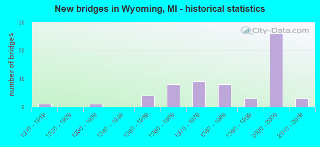
- New bridges - historical statistics
- 11910-1919
- 11930-1939
- 41950-1959
- 81960-1969
- 91970-1979
- 81980-1989
- 31990-1999
- 262000-2009
- 32010-2019
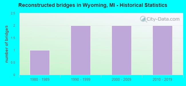
- Reconstructed bridges - Historical Statistics
- 11980-1989
- 21990-1999
- 22000-2009
- 22010-2019
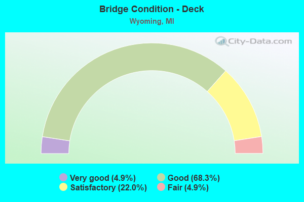
- Bridge Condition - Deck
- 4.9%Very good
- 68.3%Good
- 22.0%Satisfactory
- 4.9%Fair
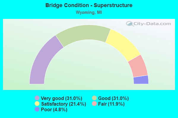
- Bridge Condition - Superstructure
- 31.0%Very good
- 31.0%Good
- 21.4%Satisfactory
- 11.9%Fair
- 4.8%Poor
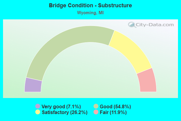
- Bridge Condition - Substructure
- 7.1%Very good
- 54.8%Good
- 26.2%Satisfactory
- 11.9%Fair
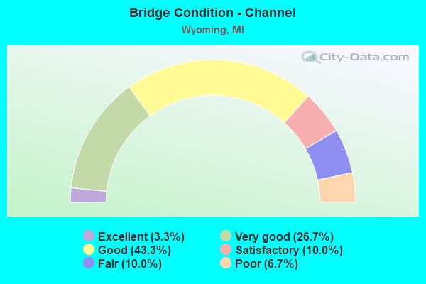
- Bridge Condition - Channel
- 3.3%Excellent
- 26.7%Very good
- 43.3%Good
- 10.0%Satisfactory
- 10.0%Fair
- 6.7%Poor
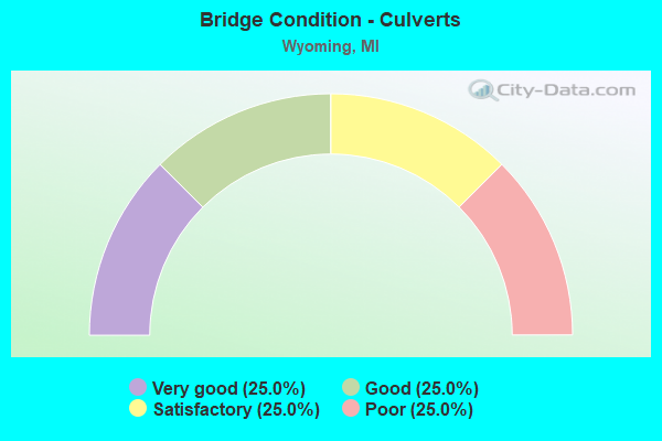
- Bridge Condition - Culverts
- 25.0%Very good
- 25.0%Good
- 25.0%Satisfactory
- 25.0%Poor
Find on map >> Show street view
Structure Number: 13028, Location: JAMETOWN TWP SEC 2 (Lat: 42.845333, Lng: -85.803983), Route carried "on" structure: Ramp State highway 6, Year Built: 2002, Status: Open, Structure Length: 2.43m (7.97ft), Average Daily Traffic: 6,600 (year 2003), Truck Traffic: 8%, Average Future Daily Traffic: 6,600 (year 2015), Design Load: HS 25 or greater, Features Intersected: RUSH CREEK
Minimum Vertical Clearance: 30.48m (100.00ft), Kilometerpoint: 0.200, Lanes on structure: 1, Owner: State Highway Agency, Approaching Roadway Width: 9.1m (29.9ft), Material/Design: Prestressed concrete, Design/Construction: Stringer/Multi-beam, Number Of Spans In Main Unit: 1, Length of Maximum Span: 24.3m (79.7ft), Curb-To-Curb Width: 10.4m (34.1ft), Out-to-Out Width: 11.5m (37.7ft)
Condition: Deck: Good, Superstructure: Very good, Substructure: Good, Channel: Satisfactory, Operating Rating: 66.7 metric tons, Method Used To Determine Operating Rating: Load Factor (LF) rating reported by rating factor (RF) method using MS18 loading, Inventory Rating: 39.9 metric tons, Method Used To Determine Inventory Rating: Load Factor (LF) rating reported by rating factor (RF) method using MS18 loading, Structural Evaluation: Better than present minimum criteria, Deck Geometry: Superior to present desirable criteria, Waterway Adequacy: Equal to present minimum criteria, Approach Roadway Alignment: Equal to present minimum criteria, Designated Inspection Frequency: Every 24 months, Inspection Date: September 2020, Deck Structure Type: Concrete Cast-file-Place, Wearing Surface/Protective System: Wearing Surface: Monolithic Concrete, Deck Protection: Epoxy Coated Reinforcing
Find on map >> Show street view
Structure Number: 13045, Location: BYRON TWP SEC 3 - 4 (Lat: 42.852725, Lng: -85.722972), Route carried "on" structure: County highway , Year Built: 2002, Status: Open, Structure Length: 8.25m (27.07ft), Average Daily Traffic: 15,000 (year 2000), Truck Traffic: 7%, Average Future Daily Traffic: 16,700 (year 2015), Design Load: HS 25 or greater, Features Intersected: M-6, RAMPS E & G, Facility Carried by Structure: BYRON CENTER AVE
Minimum Vertical Clearance: 30.48m (100.00ft), Kilometerpoint: 9.383, Lanes on structure: 4, Lanes under structure: 6, Base Highway Network: Yes (Inventory Route: 43, Subroute: 8), Owner: State Highway Agency, Approaching Roadway Width: 20.7m (67.9ft), Material/Design: Prestressed concrete, Design/Construction: Stringer/Multi-beam, Number Of Spans In Main Unit: 2, Length of Maximum Span: 40.5m (132.9ft), Curb-To-Curb Width: 27.6m (90.6ft), Out-to-Out Width: 28.6m (93.8ft)
Condition: Deck: Good, Superstructure: Satisfactory, Substructure: Good, Operating Rating: 65.2 metric tons, Method Used To Determine Operating Rating: Load Factor (LF), Inventory Rating: 45.1 metric tons, Method Used To Determine Inventory Rating: Load Factor (LF), Structural Evaluation: Equal to present minimum criteria, Deck Geometry: Superior to present desirable criteria, Underclear: Meets minimum limits, Approach Roadway Alignment: Equal to present desirable criteria, Designated Inspection Frequency: Every 24 months, Inspection Date: September 2020, Deck Structure Type: Concrete Cast-file-Place, Wearing Surface/Protective System: Wearing Surface: Monolithic Concrete, Deck Protection: Epoxy Coated Reinforcing
Find on map >> Show street view
Structure Number: 13046, Location: 0.6 MI E OF WILSON AVE (Lat: 42.852308, Lng: -85.750342), Route carried "on" structure: State highway 6, Year Built: 2002, Status: Open, Structure Length: 3.30m (10.83ft), Average Daily Traffic: 22,828 (year 2007), Truck Traffic: 8%, Average Future Daily Traffic: 34,200 (year 2000), Design Load: HS 25 or greater, Features Intersected: RUSH CREEK
Minimum Vertical Clearance: 30.48m (100.00ft), Kilometerpoint: 2.746, Lanes on structure: 2, Base Highway Network: Yes (Inventory Route: 200, Subroute: 2), Owner: State Highway Agency, Approaching Roadway Width: 13.1m (43.0ft), Skew: 4 degrees, Material/Design: Prestressed concrete, Design/Construction: Stringer/Multi-beam, Number Of Spans In Main Unit: 1, Length of Maximum Span: 33.0m (108.3ft), Curb-To-Curb Width: 13.7m (44.9ft), Out-to-Out Width: 14.8m (48.6ft)
Condition: Deck: Good, Superstructure: Very good, Substructure: Good, Channel: Good, Operating Rating: 66.1 metric tons, Method Used To Determine Operating Rating: Load Factor (LF) rating reported by rating factor (RF) method using MS18 loading, Inventory Rating: 39.5 metric tons, Method Used To Determine Inventory Rating: Load Factor (LF) rating reported by rating factor (RF) method using MS18 loading, Structural Evaluation: Better than present minimum criteria, Deck Geometry: Superior to present desirable criteria, Waterway Adequacy: Equal to present desirable criteria, Approach Roadway Alignment: Superior to present desirable criteria, Designated Inspection Frequency: Every 24 months, Inspection Date: September 2021, Deck Structure Type: Concrete Cast-file-Place, Wearing Surface/Protective System: Wearing Surface: Monolithic Concrete, Deck Protection: Epoxy Coated Reinforcing
Find on map >> Show street view
Structure Number: 13047, Location: 0.6 MI E OF WILSON AVE (Lat: 42.852078, Lng: -85.750025), Route carried "on" structure: State highway 6, Year Built: 2002, Status: Open, Structure Length: 4.00m (13.12ft), Average Daily Traffic: 22,828 (year 2007), Truck Traffic: 8%, Average Future Daily Traffic: 34,200 (year 2000), Design Load: HS 25 or greater, Features Intersected: RUSH CREEK
Minimum Vertical Clearance: 30.48m (100.00ft), Kilometerpoint: 2.773, Lanes on structure: 2, Base Highway Network: Yes (Inventory Route: 200, Subroute: 1), Owner: State Highway Agency, Approaching Roadway Width: 12.8m (42.0ft), Material/Design: Prestressed concrete, Design/Construction: Stringer/Multi-beam, Number Of Spans In Main Unit: 1, Length of Maximum Span: 40.0m (131.2ft), Curb-To-Curb Width: 13.4m (44.0ft), Out-to-Out Width: 14.7m (48.2ft)
Condition: Deck: Good, Superstructure: Good, Substructure: Good, Channel: Excellent, Operating Rating: 82.3 metric tons, Method Used To Determine Operating Rating: Load Factor (LF) rating reported by rating factor (RF) method using MS18 loading, Inventory Rating: 49.9 metric tons, Method Used To Determine Inventory Rating: Load Factor (LF) rating reported by rating factor (RF) method using MS18 loading, Structural Evaluation: Better than present minimum criteria, Deck Geometry: Superior to present desirable criteria, Waterway Adequacy: Equal to present desirable criteria, Approach Roadway Alignment: Superior to present desirable criteria, Designated Inspection Frequency: Every 24 months, Inspection Date: September 2020, Deck Structure Type: Concrete Cast-file-Place, Wearing Surface/Protective System: Wearing Surface: Monolithic Concrete, Deck Protection: Epoxy Coated Reinforcing
Find on map >> Show street view
Structure Number: 13049, Location: 1 MI E OF KENT CO LINE (Lat: 42.848575, Lng: -85.762617), Route carried "on" structure: County highway , Year Built: 2002, Status: Open, Structure Length: 8.40m (27.56ft), Average Daily Traffic: 15,800 (year 2000), Truck Traffic: 8%, Average Future Daily Traffic: 15,800 (year 2000), Design Load: HS 25 or greater, Features Intersected: M-6, RAMP G, Facility Carried by Structure: WILSON AVE
Minimum Vertical Clearance: 30.48m (100.00ft), Kilometerpoint: 8.887, Lanes on structure: 5, Lanes under structure: 5, Owner: State Highway Agency, Approaching Roadway Width: 22.8m (74.8ft), Skew: 2 degrees, Material/Design: Prestressed concrete, Design/Construction: Stringer/Multi-beam, Number Of Spans In Main Unit: 2, Length of Maximum Span: 42.0m (137.8ft), Curb-To-Curb Width: 24.0m (78.7ft), Out-to-Out Width: 25.0m (82.0ft)
Condition: Deck: Good, Superstructure: Satisfactory, Substructure: Satisfactory, Operating Rating: 74.8 metric tons, Method Used To Determine Operating Rating: Load Factor (LF) rating reported by rating factor (RF) method using MS18 loading, Inventory Rating: 33.0 metric tons, Method Used To Determine Inventory Rating: Load Factor (LF) rating reported by rating factor (RF) method using MS18 loading, Structural Evaluation: Equal to present minimum criteria, Deck Geometry: Equal to present desirable criteria, Underclear: Equal to present minimum criteria, Approach Roadway Alignment: Equal to present desirable criteria, Designated Inspection Frequency: Every 24 months, Inspection Date: September 2020, Deck Structure Type: Concrete Cast-file-Place, Wearing Surface/Protective System: Wearing Surface: Monolithic Concrete, Deck Protection: Epoxy Coated Reinforcing
Find on map >> Show street view
Structure Number: 13053, Location: JAMESTOWN TWP SEC 1 (Lat: 42.845758, Lng: -85.791714), Route carried "on" structure: State highway 6, Year Built: 2002, Status: Open, Structure Length: 3.60m (11.81ft), Average Daily Traffic: 17,279 (year 2007), Truck Traffic: 8%, Average Future Daily Traffic: 28,200 (year 2015), Design Load: HS 25 or greater, Features Intersected: MILLER DRAIN
Minimum Vertical Clearance: 30.48m (100.00ft), Kilometerpoint: 3.658, Lanes on structure: 2, Base Highway Network: Yes (Inventory Route: 370, Subroute: 6), Owner: State Highway Agency, Approaching Roadway Width: 18.3m (60.0ft), Skew: 3 degrees, Material/Design: Prestressed concrete, Design/Construction: Stringer/Multi-beam, Number Of Spans In Main Unit: 1, Length of Maximum Span: 36.0m (118.1ft), Curb-To-Curb Width: 16.2m (53.1ft), Out-to-Out Width: 17.2m (56.4ft)
Condition: Deck: Good, Superstructure: Very good, Substructure: Good, Channel: Good, Operating Rating: 77.4 metric tons, Method Used To Determine Operating Rating: Load Factor (LF) rating reported by rating factor (RF) method using MS18 loading, Inventory Rating: 46.3 metric tons, Method Used To Determine Inventory Rating: Load Factor (LF) rating reported by rating factor (RF) method using MS18 loading, Structural Evaluation: Better than present minimum criteria, Deck Geometry: Superior to present desirable criteria, Waterway Adequacy: Equal to present desirable criteria, Approach Roadway Alignment: Superior to present desirable criteria, Designated Inspection Frequency: Every 24 months, Inspection Date: August 2020, Deck Structure Type: Concrete Cast-file-Place, Wearing Surface/Protective System: Wearing Surface: Monolithic Concrete, Deck Protection: Epoxy Coated Reinforcing
Find on map >> Show street view
Structure Number: 13058, Location: JAMESTOWN TWP SEC 1 (Lat: 42.846036, Lng: -85.792022), Route carried "on" structure: State highway 6, Year Built: 2002, Status: Open, Structure Length: 3.60m (11.81ft), Average Daily Traffic: 17,279 (year 2007), Truck Traffic: 8%, Average Future Daily Traffic: 28,200 (year 2015), Design Load: HS 25 or greater, Features Intersected: MILLER DRAIN
Minimum Vertical Clearance: 30.48m (100.00ft), Kilometerpoint: 4.075, Lanes on structure: 2, Base Highway Network: Yes (Inventory Route: 370, Subroute: 7), Owner: State Highway Agency, Approaching Roadway Width: 18.3m (60.0ft), Skew: 3 degrees, Material/Design: Prestressed concrete, Design/Construction: Stringer/Multi-beam, Number Of Spans In Main Unit: 1, Length of Maximum Span: 36.0m (118.1ft), Curb-To-Curb Width: 16.1m (52.8ft), Out-to-Out Width: 17.3m (56.8ft)
Condition: Deck: Good, Superstructure: Very good, Substructure: Good, Channel: Very good, Operating Rating: 72.7 metric tons, Method Used To Determine Operating Rating: Load Factor (LF), Inventory Rating: 40.5 metric tons, Method Used To Determine Inventory Rating: Load Factor (LF), Structural Evaluation: Better than present minimum criteria, Deck Geometry: Superior to present desirable criteria, Waterway Adequacy: Equal to present minimum criteria, Approach Roadway Alignment: Superior to present desirable criteria, Designated Inspection Frequency: Every 24 months, Inspection Date: August 2020, Deck Structure Type: Concrete Cast-file-Place, Wearing Surface/Protective System: Wearing Surface: Monolithic Concrete, Deck Protection: Epoxy Coated Reinforcing
Find on map >> Show street view
Structure Number: 4817, Location: IN WYOMING (I-196 EB) (Lat: 42.930611, Lng: -85.734094), Route carried "under" structure: Interstate 196, Year Built: 1965, Structure Length: 0. m, Average Daily Traffic: 26,221 (year 2007), Truck Traffic: 9%, Features Intersected: I-196 EB
Minimum Vertical Clearance: 4.93m (16.17ft), Kilometerpoint: 8.041, Lanes on structure: 1, Lanes under structure: 2, Material/Design: Steel, Design/Construction: Stringer/Multi-beam, Length of Maximum Span: 21.6m (70.9ft)
Find on map >> Show street view
Structure Number: 4818, Location: IN WYOMING (Lat: 42.927311, Lng: -85.730247), Route carried "under" structure: ServiceState highway 21, Year Built: 1965, Structure Length: 0. m, Average Daily Traffic: 14,091 (year 2007), Truck Traffic: 11%, Features Intersected: M-21BR (CHICAGO DRIVE)
Minimum Vertical Clearance: 4.95m (16.24ft), Kilometerpoint: 5.042, Lanes on structure: 2, Lanes under structure: 5, Material/Design: Prestressed concrete, Design/Construction: Stringer/Multi-beam, Length of Maximum Span: 21.6m (70.9ft)
Find on map >> Show street view
Structure Number: 4835, Location: W LTS OF WYOMING (Lat: 42.877419, Lng: -85.782272), Route carried "under" structure: Interstate 196, Year Built: 1972, Structure Length: 0. m, Average Daily Traffic: 35,372 (year 2007), Truck Traffic: 13%, Features Intersected: I-196, Facility Carried by Structure: KENOWA AVE
Minimum Vertical Clearance: 5.03m (16.50ft), Kilometerpoint: 25.171, Lanes on structure: 2, Lanes under structure: 4, Material/Design: Steel, Design/Construction: Stringer/Multi-beam, Length of Maximum Span: 36.9m (121.1ft)
Find on map >> Show street view
Structure Number: 4966, Location: IN WYOMING (Lat: 42.866039, Lng: -85.679456), Route carried "under" structure: US 131, Year Built: 1985, Structure Length: 0. m, Average Daily Traffic: 76,037 (year 2008), Truck Traffic: 8%, Features Intersected: US-131, Facility Carried by Structure: 54TH ST
Minimum Vertical Clearance: 4.98m (16.34ft), Kilometerpoint: 11.028, Lanes on structure: 4, Lanes under structure: 8, Material/Design: Steel continuous, Design/Construction: Stringer/Multi-beam, Length of Maximum Span: 31.4m (103.0ft)
Find on map >> Show street view
Structure Number: 4967, Location: IN WYOMING (Lat: 42.884192, Lng: -85.680617), Route carried "under" structure: US 131, Year Built: 2008, Structure Length: 0. m, Average Daily Traffic: 77,568 (year 2007), Truck Traffic: 7%, Features Intersected: US-131, Facility Carried by Structure: 44TH ST
Minimum Vertical Clearance: 4.67m (15.32ft), Kilometerpoint: 13.059, Lanes on structure: 6, Lanes under structure: 6, Material/Design: Steel continuous, Design/Construction: Stringer/Multi-beam, Length of Maximum Span: 20.1m (65.9ft)
Find on map >> Show street view
Structure Number: 4968, Location: IN WYOMING (Lat: 42.898717, Lng: -85.677778), Route carried "under" structure: US 131, Year Built: 2011, Structure Length: 0. m, Average Daily Traffic: 95,642 (year 2014), Truck Traffic: 6%, Features Intersected: US-131, Facility Carried by Structure: 36TH ST
Minimum Vertical Clearance: 4.60m (15.09ft), Kilometerpoint: 14.705, Lanes on structure: 6, Lanes under structure: 6, Material/Design: Prestressed concrete, Design/Construction: Box Beam or Girders - Single/Spread, Length of Maximum Span: 20.8m (68.2ft)
Find on map >> Show street view
Structure Number: 4969, Location: IN WYOMING (Lat: 42.905983, Lng: -85.676983), Route carried "under" structure: US 131, Year Built: 1958, Structure Length: 0. m, Average Daily Traffic: 85,742 (year 2007), Truck Traffic: 6%, Features Intersected: US-131, Facility Carried by Structure: 32ND ST
Minimum Vertical Clearance: 4.62m (15.16ft), Kilometerpoint: 15.515, Lanes on structure: 2, Lanes under structure: 4, Material/Design: Prestressed concrete, Design/Construction: Box Beam or Girders - Multiple, Length of Maximum Span: 18.2m (59.7ft)
Find on map >> Show street view
Structure Number: 497, Location: IN WYOMING (Lat: 42.913253, Lng: -85.677533), Route carried "under" structure: US 131, Year Built: 2004, Structure Length: 0. m, Average Daily Traffic: 96,310 (year 2007), Truck Traffic: 7%, Features Intersected: US-131, Facility Carried by Structure: M-11
Minimum Vertical Clearance: 4.80m (15.75ft), Kilometerpoint: 16.327, Lanes on structure: 5, Lanes under structure: 5, Material/Design: Prestressed concrete, Design/Construction: Box Beam or Girders - Single/Spread, Length of Maximum Span: 23.3m (76.4ft)
Find on map >> Show street view
Structure Number: 5241, Location: NEAR BELLEVUE STREET (Lat: 42.888378, Lng: -85.664889), Route carried "under" structure: City street , Year Built: 1980, Structure Length: 0. m, Average Daily Traffic: 18,781 (year 2009), Features Intersected: DIVISION AVENUE, Facility Carried by Structure: WYOMING PEDESTRIAN
Minimum Vertical Clearance: 4.09m (13.42ft), Kilometerpoint: 14.261, Lanes under structure: 5, Material/Design: Steel, Design/Construction: Truss - Thru, Length of Maximum Span: 22.2m (72.8ft)
Find on map >> Show street view
Structure Number: 5243, Location: BETWEEN 36TH & WEXFORD (Lat: 42.899383, Lng: -85.665358), Route carried "under" structure: City street , Year Built: 1980, Structure Length: 0. m, Average Daily Traffic: 18,133 (year 2009), Features Intersected: DIVISION AVENUE, Facility Carried by Structure: WYOMING PEDESTRIAN
Minimum Vertical Clearance: 4.70m (15.42ft), Kilometerpoint: 15.484, Lanes under structure: 5, Material/Design: Steel, Design/Construction: Truss - Thru, Length of Maximum Span: 21.0m (68.9ft)
Find on map >> Show street view
Structure Number: 5244, Location: NEAR 34TH STREET (Lat: 42.902386, Lng: -85.665486), Route carried "under" structure: City street , Year Built: 1980, Structure Length: 0. m, Average Daily Traffic: 18,133 (year 2009), Features Intersected: DIVISION AVENUE, Facility Carried by Structure: WYOMING PEDESTRIAN
Minimum Vertical Clearance: 4.83m (15.85ft), Kilometerpoint: 15.817, Lanes under structure: 5, Material/Design: Steel, Design/Construction: Truss - Thru, Length of Maximum Span: 20.7m (67.9ft)
Find on map >> Show street view
Structure Number: 8744, Location: 1 MI W OF KENT CO LINE (Lat: 42.865936, Lng: -85.801875), Route carried "under" structure: Interstate 196, Year Built: 1972, Structure Length: 0. m, Average Daily Traffic: 35,372 (year 2007), Truck Traffic: 12%, Features Intersected: I-196, Facility Carried by Structure: 8TH AVE
Minimum Vertical Clearance: 4.95m (16.24ft), Kilometerpoint: 23.134, Lanes on structure: 2, Lanes under structure: 4, Material/Design: Steel, Design/Construction: Stringer/Multi-beam, Length of Maximum Span: 30.7m (100.7ft)
Find on map >> Show street view
Structure Number: 12912, Location: BYRON TWP SEC 4-5 (Lat: 42.852772, Lng: -85.742742), Route carried "under" structure: State highway 6, Year Built: 2001, Structure Length: 0. m, Average Daily Traffic: 45,656 (year 2007), Truck Traffic: 7%, Features Intersected: M-6, Facility Carried by Structure: IVANREST AVE
Minimum Vertical Clearance: 5.03m (16.50ft), Kilometerpoint: 3.372, Lanes on structure: 2, Lanes under structure: 4, Material/Design: Prestressed concrete, Design/Construction: Stringer/Multi-beam, Length of Maximum Span: 39.9m (130.9ft)
Find on map >> Show street view
Structure Number: 13024, Location: JAMESTOWN TWP SEC 1-2 (Lat: 42.846600, Lng: -85.802158), Route carried "under" structure: State highway 6, Year Built: 2002, Structure Length: 0. m, Average Daily Traffic: 34,558 (year 2007), Truck Traffic: 7%, Features Intersected: M-6, RUSH CREEK, Facility Carried by Structure: 8TH AVE
Minimum Vertical Clearance: 6.58m (21.59ft), Kilometerpoint: 2.796, Lanes on structure: 5, Lanes under structure: 5, Material/Design: Steel, Design/Construction: Stringer/Multi-beam, Length of Maximum Span: 50.1m (164.4ft)
Find on map >> Show street view
Structure Number: 13045, Location: BYRON TWP SEC 3 - 4 (Lat: 42.852725, Lng: -85.722972), Route carried "under" structure: State highway 6, Year Built: 2002, Structure Length: 0. m, Average Daily Traffic: 51,630 (year 2007), Features Intersected: M-6, RAMPS E & G, Facility Carried by Structure: BYRON CENTER AVE
Minimum Vertical Clearance: 5.33m (17.49ft), Kilometerpoint: 4.988, Lanes on structure: 4, Lanes under structure: 6, Material/Design: Prestressed concrete, Design/Construction: Stringer/Multi-beam, Length of Maximum Span: 40.5m (132.9ft)
Find on map >> Show street view
Structure Number: 13048, Location: KENT/OTTAWA CO LINE (Lat: 42.846156, Lng: -85.782378), Route carried "under" structure: State highway 6, Year Built: 2002, Structure Length: 0. m, Average Daily Traffic: 34,558 (year 2007), Features Intersected: M-6, Facility Carried by Structure: KENOWA AVE
Minimum Vertical Clearance: 5.56m (18.24ft), Kilometerpoint: 4.421, Lanes on structure: 2, Lanes under structure: 4, Material/Design: Prestressed concrete, Design/Construction: Stringer/Multi-beam, Length of Maximum Span: 40.7m (133.5ft)
Find on map >> Show street view
Structure Number: 13049, Location: 1 MI E OF KENT CO LINE (Lat: 42.848575, Lng: -85.762617), Route carried "under" structure: State highway 6, Year Built: 2002, Structure Length: 0. m, Average Daily Traffic: 45,656 (year 2007), Features Intersected: M-6, RAMP G, Facility Carried by Structure: WILSON AVE
Minimum Vertical Clearance: 5.46m (17.91ft), Kilometerpoint: 1.659, Lanes on structure: 5, Lanes under structure: 5, Material/Design: Prestressed concrete, Design/Construction: Stringer/Multi-beam, Length of Maximum Span: 42.0m (137.8ft)