Bridge Statistics for Yonkers, New York (NY)
Condition, Traffic, Stress, Structural Evaluation, Project Costs
- National Bridge Inventory (NBI) Statistics
- 187Number of bridges
- 1,450ft / 442mTotal length
- $608,764,000Total costs
- 3,452,288Total average daily traffic
- 59,866Total average daily truck traffic
- National Bridge Inventory (NBI) Registered Bridges for Yonkers
- No street view available for this location
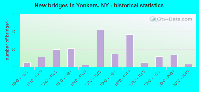
- New bridges - historical statistics
- 51900-1909
- 111910-1919
- 201920-1929
- 211930-1939
- 21940-1949
- 421950-1959
- 151960-1969
- 371970-1979
- 51980-1989
- 121990-1999
- 142000-2009
- 32010-2019
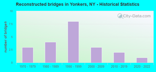
- Reconstructed bridges - Historical Statistics
- 31970-1979
- 41980-1989
- 81990-1999
- 32000-2009
- 22010-2019
- 12020-2022
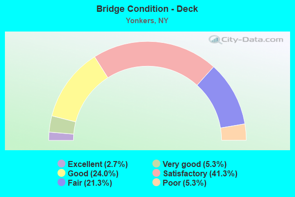
- Bridge Condition - Deck
- 2.7%Excellent
- 5.3%Very good
- 24.0%Good
- 41.3%Satisfactory
- 21.3%Fair
- 5.3%Poor
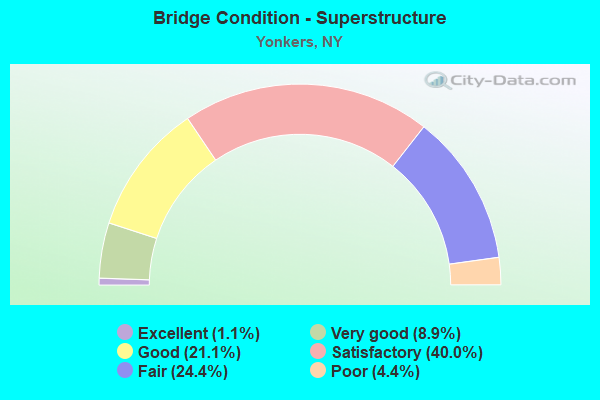
- Bridge Condition - Superstructure
- 1.1%Excellent
- 8.9%Very good
- 21.1%Good
- 40.0%Satisfactory
- 24.4%Fair
- 4.4%Poor
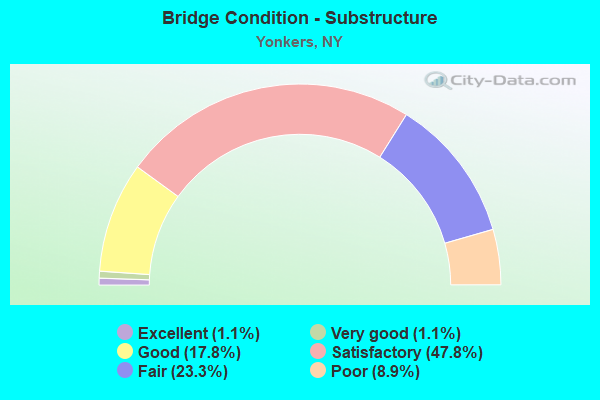
- Bridge Condition - Substructure
- 1.1%Excellent
- 1.1%Very good
- 17.8%Good
- 47.8%Satisfactory
- 23.3%Fair
- 8.9%Poor
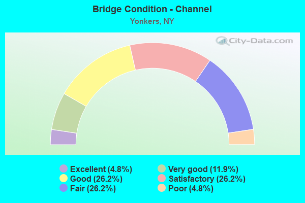
- Bridge Condition - Channel
- 4.8%Excellent
- 11.9%Very good
- 26.2%Good
- 26.2%Satisfactory
- 26.2%Fair
- 4.8%Poor
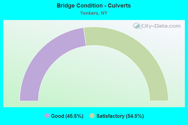
- Bridge Condition - Culverts
- 45.5%Good
- 54.5%Satisfactory
Find on map >> Show street view
Structure Number: 5501163, Location: JCT OF RTS CCP < I87 (Lat: 40.931806, Lng: -73.856942), Route carried "on" structure: City street 907K, Year Built: 1970, Year Reconstructed: 1999, Status: Open, Structure Length: 21.28m (69.82ft), Average Daily Traffic: 10,554 (year 2016), Truck Traffic: 15%, Average Future Daily Traffic: 17,872 (year 2040), Features Intersected: 100 X SB, 871X SB, RTE I
Minimum Vertical Clearance: 30+ m (98+ ft), Kilometerpoint: 0.000, Lanes on structure: 3, Lanes under structure: 12, Base Highway Network: Yes, Owner: State Highway Agency, Approaching Roadway Width: 11.0m (36.1ft), Material/Design: Steel, Design/Construction: Stringer/Multi-beam, Number Of Spans In Main Unit: 6, Length of Maximum Span: 37.4m (122.7ft), Curb or Sidewalk Widths: Left: 1.1m (3.6ft), Right: 1.1m (3.6ft), Curb-To-Curb Width: 11.0m (36.1ft), Out-to-Out Width: 14.5m (47.6ft)
Condition: Deck: Satisfactory, Superstructure: Fair, Substructure: Fair, Operating Rating: 65.1 metric tons, Method Used To Determine Operating Rating: Load and Resistance Factor Rating (LRFR) rating reported by rating factor(RF) method using HL-93 loadings, Inventory Rating: 50.2 metric tons, Method Used To Determine Inventory Rating: Load and Resistance Factor Rating (LRFR) rating reported by rating factor(RF) method using HL-93 loadings, Structural Evaluation: Somewhat better than minimum adequacy, Deck Geometry: High priority of replacement, Underclear: High priority of corrective action, Approach Roadway Alignment: Equal to present desirable criteria, Length Of Structure Improvement: 21.27m (69.78ft), Designated Inspection Frequency: Every 24 months, Inspection Date: September 2020, Bridge Improvement Cost: $11,152,000, Roadway Improvement Cost: $6,530,000, Total Project Cost: $17,682,000 ( Estimate for 2021), Deck Structure Type: Concrete Cast-file-Place, Wearing Surface/Protective System: Wearing Surface: Integral Concrete
Find on map >> Show street view
Structure Number: 550117, Location: JCT OF RTS CCP & BRP (Lat: 40.927692, Lng: -73.840233), Route carried "on" structure: City street , Year Built: 1970, Status: Open, Structure Length: 31.61m (103.71ft), Truck Traffic: 2%, Design Load: HS 20, Features Intersected: 907GX, Midland avenue, 9, Facility Carried by Structure: EB COLL.DIST.907K
Minimum Vertical Clearance: 30+ m (98+ ft), Kilometerpoint: 0.853, Lanes on structure: 2, Lanes under structure: 14, Owner: State Highway Agency, Approaching Roadway Width: 7.3m (24.0ft), Material/Design: Steel, Design/Construction: Stringer/Multi-beam, Number Of Spans In Main Unit: 8, Length of Maximum Span: 42.3m (138.8ft), Curb or Sidewalk Widths: Left: 1.4m (4.6ft), Right: 1.4m (4.6ft), Curb-To-Curb Width: 7.3m (24.0ft), Out-to-Out Width: 10.8m (35.4ft)
Condition: Deck: Fair, Superstructure: Satisfactory, Substructure: Fair, Channel: Good, Operating Rating: 67.1 metric tons, Method Used To Determine Operating Rating: Load Factor (LF), Inventory Rating: 39.9 metric tons, Method Used To Determine Inventory Rating: Load Factor (LF), Structural Evaluation: Somewhat better than minimum adequacy, Deck Geometry: High priority of replacement, Underclear: High priority of corrective action, Waterway Adequacy: Superior to present desirable criteria, Approach Roadway Alignment: Equal to present desirable criteria, Length Of Structure Improvement: 31.60m (103.67ft), Designated Inspection Frequency: Every 24 months, Inspection Date: August 2020, Bridge Improvement Cost: $13,218,000, Roadway Improvement Cost: $7,741,000, Total Project Cost: $20,959,000 ( Estimate for 2021), Deck Structure Type: Concrete Cast-file-Place, Wearing Surface/Protective System: Wearing Surface: Integral Concrete
Find on map >> Show street view
Structure Number: 550117A, Location: JCT OF RTS CCP & BRP (Lat: 40.927936, Lng: -73.841261), Route carried "on" structure: Ramp Other road , Year Built: 1970, Status: Open, Structure Length: 3.66m (12.01ft), Truck Traffic: 2%, Features Intersected: BROAD STREET, Facility Carried by Structure: 907G to 907K EB
Minimum Vertical Clearance: 30+ m (98+ ft), Kilometerpoint: 0.805, Lanes on structure: 1, Lanes under structure: 2, Owner: State Highway Agency, Approaching Roadway Width: 6.1m (20.0ft), Skew: 2 degrees, Material/Design: Steel, Design/Construction: Stringer/Multi-beam, Number Of Spans In Main Unit: 1, Length of Maximum Span: 35.0m (114.8ft), Curb or Sidewalk Widths: Left: 1.4m (4.6ft), Right: 1.4m (4.6ft), Curb-To-Curb Width: 6.1m (20.0ft), Out-to-Out Width: 9.8m (32.2ft)
Condition: Deck: Good, Superstructure: Good, Substructure: Satisfactory, Operating Rating: 97.6 metric tons, Method Used To Determine Operating Rating: Field evaluation and documented engineering judgment, Inventory Rating: 32.7 metric tons, Method Used To Determine Inventory Rating: Field evaluation and documented engineering judgment, Structural Evaluation: Equal to present minimum criteria, Deck Geometry: Somewhat better than minimum adequacy, Underclear: Meets minimum limits, Approach Roadway Alignment: Equal to present desirable criteria, Length Of Structure Improvement: 3.65m (11.98ft), Designated Inspection Frequency: Every 24 months, Inspection Date: July 2020, Bridge Improvement Cost: $2,739,000, Roadway Improvement Cost: $1,604,000, Total Project Cost: $4,343,000 ( Estimate for 2021), Deck Structure Type: Concrete Cast-file-Place, Wearing Surface/Protective System: Wearing Surface: Integral Concrete
Find on map >> Show street view
Structure Number: 550117B, Location: JCT OF RTS CCP & BRP (Lat: 40.928097, Lng: -73.841778), Route carried "on" structure: Ramp Other road , Year Built: 1970, Year Reconstructed: 2000, Status: Open, Structure Length: 3.51m (11.52ft), Truck Traffic: 2%, Features Intersected: BROAD STREET, Facility Carried by Structure: 907K EB to907G SB
Minimum Vertical Clearance: 30+ m (98+ ft), Kilometerpoint: 0.129, Lanes on structure: 1, Lanes under structure: 2, Owner: State Highway Agency, Approaching Roadway Width: 5.8m (19.0ft), Skew: 2 degrees, Material/Design: Steel, Design/Construction: Stringer/Multi-beam, Number Of Spans In Main Unit: 1, Length of Maximum Span: 33.5m (109.9ft), Curb or Sidewalk Widths: Left: 1.4m (4.6ft), Right: 1.4m (4.6ft), Curb-To-Curb Width: 5.8m (19.0ft), Out-to-Out Width: 9.8m (32.2ft)
Condition: Deck: Satisfactory, Superstructure: Good, Substructure: Fair, Operating Rating: 96.5 metric tons, Method Used To Determine Operating Rating: Field evaluation and documented engineering judgment, Inventory Rating: 32.7 metric tons, Method Used To Determine Inventory Rating: Field evaluation and documented engineering judgment, Structural Evaluation: Somewhat better than minimum adequacy, Deck Geometry: Meets minimum limits, Underclear: Meets minimum limits, Approach Roadway Alignment: Equal to present desirable criteria, Length Of Structure Improvement: 3.50m (11.48ft), Designated Inspection Frequency: Every 24 months, Inspection Date: July 2020, Bridge Improvement Cost: $2,357,000, Roadway Improvement Cost: $1,380,000, Total Project Cost: $3,738,000 ( Estimate for 2021), Deck Structure Type: Concrete Cast-file-Place, Wearing Surface/Protective System: Wearing Surface: Integral Concrete
Find on map >> Show street view
Structure Number: 5501191, Location: 0.4MI E.JCT.RTES CCP&87I (Lat: 40.929819, Lng: -73.848181), Route carried "on" structure: Other road 907K, Year Built: 1930, Status: Open, Structure Length: 2.90m (9.51ft), Average Daily Traffic: 36,562 (year 2008), Truck Traffic: 4%, Average Future Daily Traffic: 51,187 (year 2028), Design Load: HS 20, Features Intersected: KIMBALL AVENUE
Minimum Vertical Clearance: 30+ m (98+ ft), Kilometerpoint: 2.510, Lanes on structure: 3, Lanes under structure: 4, Base Highway Network: Yes, Owner: State Highway Agency, Approaching Roadway Width: 12.2m (40.0ft), Skew: 1 degrees, Material/Design: Steel, Design/Construction: Stringer/Multi-beam, Number Of Spans In Main Unit: 1, Length of Maximum Span: 28.3m (92.8ft), Curb-To-Curb Width: 10.0m (32.8ft), Out-to-Out Width: 10.5m (34.4ft)
Condition: Deck: Good, Superstructure: Good, Substructure: Satisfactory, Operating Rating: 75.5 metric tons, Method Used To Determine Operating Rating: Load and Resistance Factor Rating (LRFR) rating reported by rating factor(RF) method using HL-93 loadings, Inventory Rating: 58.3 metric tons, Method Used To Determine Inventory Rating: Load and Resistance Factor Rating (LRFR) rating reported by rating factor(RF) method using HL-93 loadings, Structural Evaluation: Equal to present minimum criteria, Deck Geometry: High priority of replacement, Underclear: Equal to present minimum criteria, Approach Roadway Alignment: Equal to present desirable criteria, Length Of Structure Improvement: 2.89m (9.48ft), Designated Inspection Frequency: Every 24 months, Inspection Date: April 2020, Bridge Improvement Cost: $1,998,000, Roadway Improvement Cost: $1,170,000, Total Project Cost: $3,168,000 ( Estimate for 2021), Deck Structure Type: Concrete Cast-file-Place, Wearing Surface/Protective System: Wearing Surface: Integral Concrete, Deck Protection: Epoxy Coated Reinforcing
Find on map >> Show street view
Structure Number: 5501192, Location: 0.4MI E.JCT.RTES CCP&87I (Lat: 40.929672, Lng: -73.848283), Route carried "on" structure: Other road 907K, Year Built: 1930, Year Reconstructed: 1985, Status: Open, Structure Length: 2.90m (9.51ft), Average Daily Traffic: 33,067 (year 2008), Truck Traffic: 2%, Average Future Daily Traffic: 46,647 (year 2040), Design Load: HS 20, Features Intersected: KIMBALL AVENUE
Minimum Vertical Clearance: 30+ m (98+ ft), Kilometerpoint: 2.510, Lanes on structure: 2, Lanes under structure: 4, Base Highway Network: Yes, Owner: State Highway Agency, Approaching Roadway Width: 12.8m (42.0ft), Skew: 1 degrees, Material/Design: Concrete, Design/Construction: Arch - Deck, Number Of Spans In Main Unit: 1, Length of Maximum Span: 28.3m (92.8ft), Curb-To-Curb Width: 12.2m (40.0ft), Out-to-Out Width: 19.2m (63.0ft)
Condition: Deck: Fair, Superstructure: Fair, Substructure: Good, Operating Rating: 92.8 metric tons, Method Used To Determine Operating Rating: Field evaluation and documented engineering judgment, Inventory Rating: 32.7 metric tons, Method Used To Determine Inventory Rating: Field evaluation and documented engineering judgment, Structural Evaluation: Somewhat better than minimum adequacy, Deck Geometry: Better than present minimum criteria, Underclear: High priority of corrective action, Approach Roadway Alignment: Equal to present desirable criteria, Length Of Structure Improvement: 2.89m (9.48ft), Designated Inspection Frequency: Every 24 months, Inspection Date: April 2020, Bridge Improvement Cost: $7,587,000, Roadway Improvement Cost: $4,443,000, Total Project Cost: $12,030,000 ( Estimate for 2021), Deck Structure Type: Concrete Cast-file-Place, Wearing Surface/Protective System: Wearing Surface: Integral Concrete, Deck Protection: Epoxy Coated Reinforcing
Find on map >> Show street view
Structure Number: 550152, Location: 0.8 MI N JCT RTS BRP+CCP (Lat: 40.937475, Lng: -73.837431), Route carried "on" structure: City street , Year Built: 1958, Year Reconstructed: 2006, Status: Open, Structure Length: 9.39m (30.81ft), Truck Traffic: 4%, Design Load: HS 20, Features Intersected: 987FX SB, 987FX SB, RTE, Facility Carried by Structure: DEWITT AVENUE
Minimum Vertical Clearance: 30+ m (98+ ft), Kilometerpoint: 0.193, Lanes on structure: 2, Lanes under structure: 8, Owner: State Highway Agency, Approaching Roadway Width: 9.4m (30.8ft), Skew: 1 degrees, Material/Design: Steel, Design/Construction: Stringer/Multi-beam, Number Of Spans In Main Unit: 4, Length of Maximum Span: 25.2m (82.7ft), Curb or Sidewalk Widths: Left: 3.2m (10.5ft), Right: 3.2m (10.5ft), Curb-To-Curb Width: 9.2m (30.2ft), Out-to-Out Width: 15.5m (50.9ft)
Condition: Deck: Satisfactory, Superstructure: Satisfactory, Substructure: Poor, Channel: Satisfactory, Operating Rating: 47.3 metric tons, Method Used To Determine Operating Rating: Load and Resistance Factor Rating (LRFR) rating reported by rating factor(RF) method using HL-93 loadings, Inventory Rating: 36.3 metric tons, Method Used To Determine Inventory Rating: Load and Resistance Factor Rating (LRFR) rating reported by rating factor(RF) method using HL-93 loadings, Structural Evaluation: Meets minimum limits, Deck Geometry: Better than present minimum criteria, Underclear: High priority of corrective action, Waterway Adequacy: Equal to present minimum criteria, Approach Roadway Alignment: Equal to present desirable criteria, Length Of Structure Improvement: 9.38m (30.77ft), Designated Inspection Frequency: Every 24 months, Inspection Date: June 2021, Bridge Improvement Cost: $6,740,000, Roadway Improvement Cost: $3,947,000, Total Project Cost: $10,686,000 ( Estimate for 2021), Deck Structure Type: Concrete Cast-file-Place, Wearing Surface/Protective System: Wearing Surface: Bituminous, Membrane: Other
Find on map >> Show street view
Structure Number: 550153, Location: JCT OF RTS BRP < SBSP (Lat: 40.938139, Lng: -73.838575), Route carried "on" structure: Other road 907G, Year Built: 1958, Status: Open, Structure Length: 10.03m (32.91ft), Average Daily Traffic: 23,973 (year 2020), Average Future Daily Traffic: 33,818 (year 2040), Design Load: HS 20, Features Intersected: 987F 987F87011000 SB, RT
Minimum Vertical Clearance: 30+ m (98+ ft), Kilometerpoint: 4.747, Lanes on structure: 2, Lanes under structure: 5, Owner: State Highway Agency, Approaching Roadway Width: 7.3m (24.0ft), Skew: 5 degrees, Material/Design: Steel, Design/Construction: Stringer/Multi-beam, Number Of Spans In Main Unit: 3, Length of Maximum Span: 39.6m (129.9ft), Curb or Sidewalk Widths: Left: 1.2m (3.9ft), Right: 1.2m (3.9ft), Curb-To-Curb Width: 7.3m (24.0ft), Out-to-Out Width: 10.1m (33.1ft)
Condition: Deck: Satisfactory, Superstructure: Fair, Substructure: Poor, Channel: Good, Operating Rating: 46.7 metric tons, Method Used To Determine Operating Rating: Load and Resistance Factor Rating (LRFR) rating reported by rating factor(RF) method using HL-93 loadings, Inventory Rating: 36.0 metric tons, Method Used To Determine Inventory Rating: Load and Resistance Factor Rating (LRFR) rating reported by rating factor(RF) method using HL-93 loadings, Structural Evaluation: Meets minimum limits, Deck Geometry: High priority of replacement, Underclear: High priority of corrective action, Waterway Adequacy: Meets minimum limits, Approach Roadway Alignment: Equal to present desirable criteria, Length Of Structure Improvement: 10.02m (32.87ft), Designated Inspection Frequency: Every 24 months, Inspection Date: July 2021, Bridge Improvement Cost: $5,077,000, Roadway Improvement Cost: $2,973,000, Total Project Cost: $8,049,000 ( Estimate for 2021), Deck Structure Type: Concrete Cast-file-Place, Wearing Surface/Protective System: Wearing Surface: Integral Concrete
Find on map >> Show street view
Structure Number: 550156, Location: .6 MI S JCT SBSP & SH100 (Lat: 40.939831, Lng: -73.841669), Route carried "on" structure: City street , Year Built: 1958, Status: Open, Structure Length: 6.86m (22.51ft), Average Daily Traffic: 4,828 (year 2017), Truck Traffic: 3%, Average Future Daily Traffic: 5,865 (year 2040), Design Load: HS 20, Features Intersected: 987F987F87011003 WB, RT, Facility Carried by Structure: KIMBALL AVENUE
Minimum Vertical Clearance: 30+ m (98+ ft), Kilometerpoint: 4.763, Lanes on structure: 4, Lanes under structure: 6, Owner: State Highway Agency, Approaching Roadway Width: 13.4m (44.0ft), Material/Design: Steel, Design/Construction: Stringer/Multi-beam, Number Of Spans In Main Unit: 3, Length of Maximum Span: 27.7m (90.9ft), Curb or Sidewalk Widths: Left: 2.6m (8.5ft), Right: 2.6m (8.5ft), Curb-To-Curb Width: 14.6m (47.9ft), Out-to-Out Width: 20.2m (66.3ft)
Condition: Deck: Fair, Superstructure: Fair, Substructure: Poor, Channel: Very good, Operating Rating: 61.6 metric tons, Method Used To Determine Operating Rating: Load and Resistance Factor Rating (LRFR) rating reported by rating factor(RF) method using HL-93 loadings, Inventory Rating: 47.6 metric tons, Method Used To Determine Inventory Rating: Load and Resistance Factor Rating (LRFR) rating reported by rating factor(RF) method using HL-93 loadings, Structural Evaluation: Meets minimum limits, Deck Geometry: High priority of replacement, Underclear: High priority of corrective action, Waterway Adequacy: Equal to present minimum criteria, Approach Roadway Alignment: Equal to present desirable criteria, Length Of Structure Improvement: 6.85m (22.47ft), Designated Inspection Frequency: Every 24 months, Inspection Date: April 2020, Bridge Improvement Cost: $6,245,000, Roadway Improvement Cost: $3,657,000, Total Project Cost: $9,902,000 ( Estimate for 2021), Deck Structure Type: Concrete Cast-file-Place, Wearing Surface/Protective System: Wearing Surface: Integral Concrete
Find on map >> Show street view
Structure Number: 550157, Location: 0.5 MI S JCT RTS SBSP+100 (Lat: 40.940728, Lng: -73.843506), Route carried "on" structure: County highway , Year Built: 1958, Status: Open, Structure Length: 7.28m (23.88ft), Average Daily Traffic: 8,942 (year 2020), Truck Traffic: 4%, Average Future Daily Traffic: 10,862 (year 2040), Design Load: HS 20, Features Intersected: 987F 987F87011004 SB, RT, Facility Carried by Structure: PALMER ROAD
Minimum Vertical Clearance: 30+ m (98+ ft), Kilometerpoint: 0.756, Lanes on structure: 2, Lanes under structure: 6, Owner: State Highway Agency, Approaching Roadway Width: 14.6m (47.9ft), Skew: 5 degrees, Material/Design: Steel, Design/Construction: Stringer/Multi-beam, Number Of Spans In Main Unit: 3, Length of Maximum Span: 29.5m (96.8ft), Curb or Sidewalk Widths: Left: 2.3m (7.5ft), Right: 2.3m (7.5ft), Curb-To-Curb Width: 14.6m (47.9ft), Out-to-Out Width: 20.2m (66.3ft)
Condition: Deck: Fair, Superstructure: Fair, Substructure: Fair, Channel: Good, Operating Rating: 61.7 metric tons, Method Used To Determine Operating Rating: Load Factor (LF), Inventory Rating: 36.3 metric tons, Method Used To Determine Inventory Rating: Load Factor (LF), Structural Evaluation: Somewhat better than minimum adequacy, Deck Geometry: Superior to present desirable criteria, Underclear: Somewhat better than minimum adequacy, Waterway Adequacy: Equal to present minimum criteria, Approach Roadway Alignment: Equal to present desirable criteria, Length Of Structure Improvement: 7.28m (23.88ft), Designated Inspection Frequency: Every 24 months, Inspection Date: December 2021, Bridge Improvement Cost: $8,817,000, Roadway Improvement Cost: $5,163,000, Total Project Cost: $13,980,000 ( Estimate for 2021), Deck Structure Type: Concrete Cast-file-Place, Wearing Surface/Protective System: Wearing Surface: Integral Concrete
Find on map >> Show street view
Structure Number: 550158, Location: 1.5 MI SW OF TUCKAHOE (Lat: 40.946278, Lng: -73.849075), Route carried "on" structure: Ramp City street 987F, Year Built: 1962, Status: Open, Structure Length: 1.74m (5.71ft), Average Daily Traffic: 3,440 (year 2016), Average Future Daily Traffic: 4,852 (year 2040), Design Load: HS 20, Features Intersected: GRASSY SPRAIN BRK
Minimum Vertical Clearance: 30+ m (98+ ft), Kilometerpoint: 0.241, Lanes on structure: 1, Owner: State Highway Agency, Approaching Roadway Width: 8.8m (28.9ft), Skew: 5 degrees, Material/Design: Concrete continuous, Design/Construction: Culvert, Number Of Spans In Main Unit: 2, Length of Maximum Span: 8.2m (26.9ft), Curb-To-Curb Width: 8.8m (28.9ft), Out-to-Out Width: 10.1m (33.1ft)
Condition: Channel: Good, Culverts: Satisfactory, Operating Rating: 55.4 metric tons, Method Used To Determine Operating Rating: Load and Resistance Factor Rating (LRFR) rating reported by rating factor(RF) method using HL-93 loadings, Inventory Rating: 42.8 metric tons, Method Used To Determine Inventory Rating: Load and Resistance Factor Rating (LRFR) rating reported by rating factor(RF) method using HL-93 loadings, Structural Evaluation: Equal to present minimum criteria, Deck Geometry: Superior to present desirable criteria, Waterway Adequacy: Superior to present desirable criteria, Approach Roadway Alignment: Equal to present desirable criteria, Length Of Structure Improvement: 1.73m (5.68ft), Designated Inspection Frequency: Every 24 months, Inspection Date: August 2020, Bridge Improvement Cost: $600,000, Roadway Improvement Cost: $351,000, Total Project Cost: $951,000 ( Estimate for 2021), Wearing Surface/Protective System: Wearing Surface: Bituminous
Find on map >> Show street view
Structure Number: 550159, Location: 1.6 MI SW OF TUCKAHOE (Lat: 40.947972, Lng: -73.850639), Route carried "on" structure: Ramp City street , Year Built: 1958, Status: Open, Structure Length: 1.71m (5.61ft), Average Daily Traffic: 10,718 (year 2016), Average Future Daily Traffic: 15,119 (year 2040), Design Load: HS 20, Features Intersected: GRASSY SPRAIN BRK, Facility Carried by Structure: RAMP K NB TO 987F
Minimum Vertical Clearance: 30+ m (98+ ft), Kilometerpoint: 0.129, Lanes on structure: 1, Owner: State Highway Agency, Approaching Roadway Width: 6.1m (20.0ft), Skew: 5 degrees, Material/Design: Concrete continuous, Design/Construction: Culvert, Number Of Spans In Main Unit: 2, Length of Maximum Span: 7.5m (24.6ft), Curb-To-Curb Width: 6.1m (20.0ft), Out-to-Out Width: 10.1m (33.1ft)
Condition: Channel: Satisfactory, Culverts: Good, Inventory Rating: 67.1 metric tons, Method Used To Determine Inventory Rating: Load Factor (LF), Structural Evaluation: Better than present minimum criteria, Deck Geometry: Somewhat better than minimum adequacy, Waterway Adequacy: Superior to present desirable criteria, Approach Roadway Alignment: Equal to present minimum criteria, Length Of Structure Improvement: 1.70m (5.58ft), Designated Inspection Frequency: Every 24 months, Inspection Date: July 2020, Bridge Improvement Cost: $589,000, Roadway Improvement Cost: $345,000, Total Project Cost: $934,000 ( Estimate for 2021), Wearing Surface/Protective System: Wearing Surface: Bituminous
Find on map >> Show street view
Structure Number: 55016, Location: 1.6 MI W OF TUCKAHOE (Lat: 40.950594, Lng: -73.852258), Route carried "on" structure: Ramp Other road 987F, Year Built: 1970, Status: Open, Structure Length: 1.86m (6.10ft), Average Daily Traffic: 1,766 (year 1997), Truck Traffic: 13%, Average Future Daily Traffic: 2,472 (year 2017), Features Intersected: GRASSY SPRAIN BROOK
Minimum Vertical Clearance: 30+ m (98+ ft), Kilometerpoint: 0.000, Lanes on structure: 1, Base Highway Network: Yes, Owner: State Highway Agency, Approaching Roadway Width: 6.1m (20.0ft), Skew: 5 degrees, Material/Design: Concrete continuous, Design/Construction: Culvert, Number Of Spans In Main Unit: 2, Length of Maximum Span: 9.1m (29.9ft), Curb-To-Curb Width: 8.5m (27.9ft), Out-to-Out Width: 9.4m (30.8ft)
Condition: Channel: Poor, Culverts: Satisfactory, Operating Rating: 81.3 metric tons, Method Used To Determine Operating Rating: Load and Resistance Factor Rating (LRFR) rating reported by rating factor(RF) method using HL-93 loadings, Inventory Rating: 62.9 metric tons, Method Used To Determine Inventory Rating: Load and Resistance Factor Rating (LRFR) rating reported by rating factor(RF) method using HL-93 loadings, Structural Evaluation: Equal to present minimum criteria, Deck Geometry: Superior to present desirable criteria, Waterway Adequacy: Equal to present desirable criteria, Approach Roadway Alignment: Equal to present desirable criteria, Length Of Structure Improvement: 1.85m (6.07ft), Designated Inspection Frequency: Every 24 months, Inspection Date: June 2020, Bridge Improvement Cost: $603,000, Roadway Improvement Cost: $353,000, Total Project Cost: $956,000 ( Estimate for 2021), Wearing Surface/Protective System: Wearing Surface: Bituminous, Membrane: Other
Find on map >> Show street view
Structure Number: 5501619, Location: 0.4 MI N JCT SBSP & SH100 (Lat: 40.950994, Lng: -73.852975), Route carried "on" structure: City street 987F, Year Built: 1962, Status: Open, Structure Length: 1.22m (4.00ft), Average Daily Traffic: 101,386 (year 2014), Truck Traffic: 1%, Average Future Daily Traffic: 143,025 (year 2040), Features Intersected: GRASSY SPRAIN BRK
Minimum Vertical Clearance: 30+ m (98+ ft), Kilometerpoint: 2.092, Lanes on structure: 6, Base Highway Network: Yes, Owner: State Highway Agency, Approaching Roadway Width: 29.3m (96.1ft), Skew: 24 degrees, Material/Design: Concrete continuous, Design/Construction: Culvert, Number Of Spans In Main Unit: 2, Length of Maximum Span: 5.8m (19.0ft)
Condition: Channel: Satisfactory, Culverts: Satisfactory, Inventory Rating: 73.5 metric tons, Method Used To Determine Inventory Rating: Load Factor (LF), Structural Evaluation: Equal to present minimum criteria, Waterway Adequacy: Meets minimum limits, Approach Roadway Alignment: Equal to present desirable criteria, Length Of Structure Improvement: 1.21m (3.97ft), Designated Inspection Frequency: Every 24 months, Inspection Date: September 2020, Bridge Improvement Cost: $1,005,000, Roadway Improvement Cost: $589,000, Total Project Cost: $1,594,000 ( Estimate for 2021), Wearing Surface/Protective System: Wearing Surface: Bituminous
Find on map >> Show street view
Structure Number: 550162, Location: TUCKAHOE RD & SBSP RAMP L (Lat: 40.951514, Lng: -73.853650), Route carried "on" structure: Ramp Interstate 987F, Year Built: 1958, Status: Open, Structure Length: 0.94m (3.08ft), Average Daily Traffic: 2,158 (year 1997), Truck Traffic: 13%, Average Future Daily Traffic: 3,021 (year 2017), Features Intersected: GRASSY SPRAIN BRK
Minimum Vertical Clearance: 30+ m (98+ ft), Kilometerpoint: 0.000, Lanes on structure: 1, Base Highway Network: Yes, Owner: State Highway Agency, Approaching Roadway Width: 9.1m (29.9ft), Material/Design: Concrete, Design/Construction: Culvert, Number Of Spans In Main Unit: 2, Length of Maximum Span: 4.2m (13.8ft)
Condition: Channel: Fair, Culverts: Good, Operating Rating: 46.7 metric tons, Method Used To Determine Operating Rating: Load and Resistance Factor Rating (LRFR) rating reported by rating factor(RF) method using HL-93 loadings, Inventory Rating: 36.3 metric tons, Method Used To Determine Inventory Rating: Load and Resistance Factor Rating (LRFR) rating reported by rating factor(RF) method using HL-93 loadings, Structural Evaluation: Better than present minimum criteria, Waterway Adequacy: Meets minimum limits, Approach Roadway Alignment: Equal to present minimum criteria, Length Of Structure Improvement: 0.94m (3.08ft), Designated Inspection Frequency: Every 24 months, Inspection Date: August 2020, Bridge Improvement Cost: $243,000, Roadway Improvement Cost: $142,000, Total Project Cost: $386,000 ( Estimate for 2021), Wearing Surface/Protective System: Wearing Surface: Bituminous
Find on map >> Show street view
Structure Number: 550163, Location: 1.7 MI SW OF TUCKAHOE (Lat: 40.953108, Lng: -73.853803), Route carried "on" structure: Ramp Other road 987F, Year Built: 1962, Status: Open, Structure Length: 0.73m (2.40ft), Average Daily Traffic: 2,423 (year 1997), Truck Traffic: 13%, Average Future Daily Traffic: 3,392 (year 2017), Design Load: HS 20, Features Intersected: GRASSY SPRAIN BK
Minimum Vertical Clearance: 30+ m (98+ ft), Kilometerpoint: 0.000, Lanes on structure: 1, Base Highway Network: Yes, Owner: State Highway Agency, Approaching Roadway Width: 9.1m (29.9ft), Skew: 2 degrees, Material/Design: Concrete, Design/Construction: Culvert, Number Of Spans In Main Unit: 1, Length of Maximum Span: 6.7m (22.0ft), Curb-To-Curb Width: 9.1m (29.9ft), Out-to-Out Width: 13.9m (45.6ft)
Condition: Channel: Good, Culverts: Good, Operating Rating: 65.4 metric tons, Method Used To Determine Operating Rating: Load and Resistance Factor Rating (LRFR) rating reported by rating factor(RF) method using HL-93 loadings, Inventory Rating: 50.5 metric tons, Method Used To Determine Inventory Rating: Load and Resistance Factor Rating (LRFR) rating reported by rating factor(RF) method using HL-93 loadings, Structural Evaluation: Better than present minimum criteria, Deck Geometry: Superior to present desirable criteria, Waterway Adequacy: Superior to present desirable criteria, Approach Roadway Alignment: Equal to present minimum criteria, Length Of Structure Improvement: 0.73m (2.40ft), Designated Inspection Frequency: Every 24 months, Inspection Date: June 2020, Bridge Improvement Cost: $286,000, Roadway Improvement Cost: $167,000, Total Project Cost: $453,000 ( Estimate for 2021), Wearing Surface/Protective System: Wearing Surface: Bituminous
Find on map >> Show street view
Structure Number: 550164, Location: 0.7 MI N JCT RTS SBSP<100 (Lat: 40.957297, Lng: -73.851553), Route carried "on" structure: City street 987F, Year Built: 1961, Status: Open, Structure Length: 0.94m (3.08ft), Average Daily Traffic: 101,386 (year 2014), Truck Traffic: 1%, Average Future Daily Traffic: 143,025 (year 2040), Features Intersected: GRASSY SPRAIN BK
Minimum Vertical Clearance: 30+ m (98+ ft), Kilometerpoint: 2.832, Lanes on structure: 3, Base Highway Network: Yes, Owner: State Highway Agency, Approaching Roadway Width: 13.4m (44.0ft), Skew: 4 degrees, Material/Design: Concrete, Design/Construction: Culvert, Number Of Spans In Main Unit: 1, Length of Maximum Span: 8.8m (28.9ft)
Condition: Channel: Fair, Culverts: Good, Operating Rating: 76.2 metric tons, Method Used To Determine Operating Rating: Load Factor (LF), Inventory Rating: 45.4 metric tons, Method Used To Determine Inventory Rating: Load Factor (LF), Structural Evaluation: Better than present minimum criteria, Waterway Adequacy: Meets minimum limits, Approach Roadway Alignment: Equal to present desirable criteria, Length Of Structure Improvement: 0.94m (3.08ft), Designated Inspection Frequency: Every 24 months, Inspection Date: August 2020, Bridge Improvement Cost: $357,000, Roadway Improvement Cost: $209,000, Total Project Cost: $566,000 ( Estimate for 2021), Wearing Surface/Protective System: Wearing Surface: Bituminous
Find on map >> Show street view
Structure Number: 551379, Location: 2 MI S JCT I87 & CC PRKWY (Lat: 40.908778, Lng: -73.877731), Route carried "on" structure: County highway , Year Built: 2002, Status: Open, Structure Length: 3.51m (11.52ft), Truck Traffic: 6%, Design Load: HS 25 or greater, Features Intersected: 87IX NB, RTE I87, Facility Carried by Structure: COUNTY ROAD 127
Minimum Vertical Clearance: 30+ m (98+ ft), Kilometerpoint: 0.853, Lanes on structure: 4, Lanes under structure: 6, Owner: State Toll Authority, Approaching Roadway Width: 14.6m (47.9ft), Skew: 1 degrees, Material/Design: Steel, Design/Construction: Stringer/Multi-beam, Number Of Spans In Main Unit: 1, Length of Maximum Span: 34.1m (111.9ft), Curb or Sidewalk Widths: Left: 3.0m (9.8ft), Right: 2.6m (8.5ft), Curb-To-Curb Width: 16.4m (53.8ft), Out-to-Out Width: 23.4m (76.8ft)
Condition: Deck: Satisfactory, Superstructure: Good, Substructure: Satisfactory, Operating Rating: 97.2 metric tons, Method Used To Determine Operating Rating: Load and Resistance Factor Rating (LRFR) rating reported by rating factor(RF) method using HL-93 loadings, Inventory Rating: 81.3 metric tons, Method Used To Determine Inventory Rating: Load and Resistance Factor Rating (LRFR) rating reported by rating factor(RF) method using HL-93 loadings, Structural Evaluation: Equal to present minimum criteria, Deck Geometry: Meets minimum limits, Underclear: High priority of corrective action, Approach Roadway Alignment: Equal to present desirable criteria, Length Of Structure Improvement: 3.50m (11.48ft), Designated Inspection Frequency: Every 24 months, Inspection Date: April 2021, Bridge Improvement Cost: $4,906,000, Roadway Improvement Cost: $2,873,000, Total Project Cost: $7,778,000 ( Estimate for 2021), Deck Structure Type: Concrete Cast-file-Place, Wearing Surface/Protective System: Wearing Surface: Integral Concrete, Deck Protection: Galvanized Reinforcing
Find on map >> Show street view
Structure Number: 55138, Location: 1.7 MI S JCT I87 & CCP (Lat: 40.912297, Lng: -73.875236), Route carried "on" structure: City street , Year Built: 2004, Status: Open, Structure Length: 6.07m (19.91ft), Truck Traffic: 4%, Design Load: HS 25 or greater, Features Intersected: I-87 SB, RTE I87, RTE 10, Facility Carried by Structure: HALL PLACE
Minimum Vertical Clearance: 30+ m (98+ ft), Kilometerpoint: 0.193, Lanes on structure: 4, Lanes under structure: 8, Owner: State Toll Authority, Approaching Roadway Width: 12.2m (40.0ft), Material/Design: Steel continuous, Design/Construction: Stringer/Multi-beam, Number Of Spans In Main Unit: 2, Length of Maximum Span: 33.5m (109.9ft), Curb or Sidewalk Widths: Left: 2.3m (7.5ft), Right: 2.3m (7.5ft), Curb-To-Curb Width: 12.3m (40.4ft), Out-to-Out Width: 17.9m (58.7ft)
Condition: Deck: Good, Superstructure: Very good, Substructure: Satisfactory, Inventory Rating: 76.2 metric tons, Method Used To Determine Inventory Rating: Load Factor (LF), Structural Evaluation: Equal to present minimum criteria, Deck Geometry: High priority of replacement, Underclear: High priority of corrective action, Approach Roadway Alignment: Equal to present desirable criteria, Length Of Structure Improvement: 6.06m (19.88ft), Designated Inspection Frequency: Every 24 months, Inspection Date: July 2020, Bridge Improvement Cost: $4,811,000, Roadway Improvement Cost: $2,817,000, Total Project Cost: $7,628,000 ( Estimate for 2021), Deck Structure Type: Concrete Cast-file-Place, Wearing Surface/Protective System: Wearing Surface: Integral Concrete, Deck Protection: Galvanized Reinforcing
Find on map >> Show street view
Structure Number: 551382, Location: 0.9 MI S JCT RTS I87+CCP (Lat: 40.920686, Lng: -73.865597), Route carried "on" structure: City street , Year Built: 2002, Status: Open, Structure Length: 3.44m (11.29ft), Average Daily Traffic: 3,600 (year 2006), Truck Traffic: 3%, Average Future Daily Traffic: 5,040 (year 2026), Design Load: HS 25 or greater, Features Intersected: 87IX SB, RTE I87, Facility Carried by Structure: CLARK STREET
Minimum Vertical Clearance: 30+ m (98+ ft), Kilometerpoint: 0.000, Lanes on structure: 4, Lanes under structure: 6, Owner: State Toll Authority, Approaching Roadway Width: 18.3m (60.0ft), Material/Design: Steel, Design/Construction: Stringer/Multi-beam, Number Of Spans In Main Unit: 1, Length of Maximum Span: 33.5m (109.9ft), Curb or Sidewalk Widths: Left: 3.0m (9.8ft), Right: 3.0m (9.8ft), Curb-To-Curb Width: 17.9m (58.7ft), Out-to-Out Width: 24.9m (81.7ft)
Condition: Deck: Good, Superstructure: Good, Substructure: Good, Inventory Rating: 70.8 metric tons, Method Used To Determine Inventory Rating: Load Factor (LF), Structural Evaluation: Better than present minimum criteria, Deck Geometry: Somewhat better than minimum adequacy, Underclear: High priority of corrective action, Approach Roadway Alignment: Equal to present minimum criteria, Length Of Structure Improvement: 3.44m (11.29ft), Designated Inspection Frequency: Every 24 months, Inspection Date: April 2020, Bridge Improvement Cost: $5,334,000, Roadway Improvement Cost: $3,124,000, Total Project Cost: $8,458,000 ( Estimate for 2021), Deck Structure Type: Concrete Cast-file-Place, Wearing Surface/Protective System: Wearing Surface: Integral Concrete, Deck Protection: Galvanized Reinforcing
Find on map >> Show street view
Structure Number: 5513839, Location: 0.4 MI S JCT RTS I87&CCP (Lat: 40.925206, Lng: -73.858303), Route carried "on" structure: Interstate 87, Year Built: 1954, Year Reconstructed: 1982, Status: Open, Structure Length: 3.02m (9.91ft), Average Daily Traffic: 68,622 (year 2018), Truck Traffic: 9%, Average Future Daily Traffic: 116,204 (year 2040), Design Load: HS 20+Mod, Features Intersected: MILE SQUARE ROAD
Minimum Vertical Clearance: 30+ m (98+ ft), Kilometerpoint: 2.832, Lanes on structure: 7, Lanes under structure: 4, Base Highway Network: Yes, Toll: On Interstate toll segment, Owner: State Toll Authority, Approaching Roadway Width: 34.7m (113.8ft), Skew: 24 degrees, Material/Design: Steel, Design/Construction: Stringer/Multi-beam, Number Of Spans In Main Unit: 1, Length of Maximum Span: 28.7m (94.2ft), Curb-To-Curb Width: 34.4m (112.9ft), Out-to-Out Width: 35.8m (117.5ft)
Condition: Deck: Good, Superstructure: Good, Substructure: Satisfactory, Operating Rating: 91.6 metric tons, Method Used To Determine Operating Rating: Load Factor (LF), Inventory Rating: 54.4 metric tons, Method Used To Determine Inventory Rating: Load Factor (LF), Structural Evaluation: Equal to present minimum criteria, Deck Geometry: Superior to present desirable criteria, Underclear: High priority of corrective action, Approach Roadway Alignment: Equal to present desirable criteria, Length Of Structure Improvement: 3.01m (9.88ft), Designated Inspection Frequency: Every 24 months, Inspection Date: August 2021, Bridge Improvement Cost: $9,064,000, Roadway Improvement Cost: $5,308,000, Total Project Cost: $14,372,000 ( Estimate for 2021), Deck Structure Type: Concrete Cast-file-Place, Wearing Surface/Protective System: Wearing Surface: Bituminous, Membrane: Other, Deck Protection: Epoxy Coated Reinforcing
Find on map >> Show street view
Structure Number: 551384, Location: 0.4 MI N JCT RTS I87+100 (Lat: 40.945122, Lng: -73.854392), Route carried "on" structure: County highway , Year Built: 1954, Status: Open, Structure Length: 4.15m (13.62ft), Truck Traffic: 3%, Design Load: HS 20+Mod, Features Intersected: 87IX NB, RTE I87, Facility Carried by Structure: PALMER ROAD
Minimum Vertical Clearance: 30+ m (98+ ft), Kilometerpoint: 0.531, Lanes on structure: 2, Lanes under structure: 6, Owner: State Toll Authority, Approaching Roadway Width: 12.2m (40.0ft), Material/Design: Steel, Design/Construction: Stringer/Multi-beam, Number Of Spans In Main Unit: 2, Length of Maximum Span: 20.7m (67.9ft), Curb or Sidewalk Widths: Left: 2.9m (9.5ft), Right: 2.9m (9.5ft), Curb-To-Curb Width: 12.2m (40.0ft), Out-to-Out Width: 18.9m (62.0ft)
Condition: Deck: Good, Superstructure: Satisfactory, Substructure: Good, Operating Rating: 68.0 metric tons, Method Used To Determine Operating Rating: Load Factor (LF), Inventory Rating: 39.9 metric tons, Method Used To Determine Inventory Rating: Load Factor (LF), Structural Evaluation: Equal to present minimum criteria, Deck Geometry: Superior to present desirable criteria, Underclear: High priority of corrective action, Approach Roadway Alignment: Equal to present desirable criteria, Length Of Structure Improvement: 4.14m (13.58ft), Designated Inspection Frequency: Every 24 months, Inspection Date: August 2021, Bridge Improvement Cost: $3,005,000, Roadway Improvement Cost: $1,760,000, Total Project Cost: $4,765,000 ( Estimate for 2021), Deck Structure Type: Concrete Cast-file-Place, Wearing Surface/Protective System: Wearing Surface: Monolithic Concrete
Find on map >> Show street view
Structure Number: 5513859, Location: 1.3 MI N JCT RTS I 87+100 (Lat: 40.955322, Lng: -73.861150), Route carried "on" structure: Interstate 87, Year Built: 1953, Year Reconstructed: 1982, Status: Open, Structure Length: 5.30m (17.39ft), Average Daily Traffic: 55,430 (year 2019), Truck Traffic: 12%, Average Future Daily Traffic: 93,865 (year 2040), Design Load: HS 20+Mod, Features Intersected: TUCKAHOE ROAD
Minimum Vertical Clearance: 30+ m (98+ ft), Kilometerpoint: 6.420, Lanes on structure: 8, Lanes under structure: 4, Base Highway Network: Yes, Toll: On Interstate toll segment, Owner: State Toll Authority, Approaching Roadway Width: 41.5m (136.2ft), Skew: 21 degrees, Material/Design: Steel, Design/Construction: Stringer/Multi-beam, Number Of Spans In Main Unit: 3, Length of Maximum Span: 26.8m (87.9ft), Curb-To-Curb Width: 39.7m (130.2ft), Out-to-Out Width: 41.9m (137.5ft)
Condition: Deck: Satisfactory, Superstructure: Satisfactory, Substructure: Fair, Operating Rating: 57.2 metric tons, Method Used To Determine Operating Rating: Load Factor (LF), Inventory Rating: 34.5 metric tons, Method Used To Determine Inventory Rating: Load Factor (LF), Structural Evaluation: Somewhat better than minimum adequacy, Deck Geometry: Superior to present desirable criteria, Underclear: Meets minimum limits, Approach Roadway Alignment: Equal to present desirable criteria, Length Of Structure Improvement: 5.30m (17.39ft), Designated Inspection Frequency: Every 24 months, Inspection Date: August 2021, Bridge Improvement Cost: $9,049,000, Roadway Improvement Cost: $5,299,000, Total Project Cost: $14,347,000 ( Estimate for 2021), Deck Structure Type: Concrete Cast-file-Place, Wearing Surface/Protective System: Wearing Surface: Bituminous, Membrane: Other, Deck Protection: Epoxy Coated Reinforcing
Find on map >> Show street view
Structure Number: 551386, Location: 0.8 MI N JCT 87I & TUCKAH (Lat: 40.966919, Lng: -73.860981), Route carried "on" structure: Other road , Year Built: 2011, Status: Open, Structure Length: 5.64m (18.50ft), Truck Traffic: 4%, Design Load: HS 25 or greater, Features Intersected: 871 SB, RTE I87, Facility Carried by Structure: RIDGE HILL BLVD.
Minimum Vertical Clearance: 30+ m (98+ ft), Kilometerpoint: 1.786, Lanes on structure: 4, Lanes under structure: 6, Owner: City or Municipal Highway Agency, Approaching Roadway Width: 17.1m (56.1ft), Skew: 2 degrees, Material/Design: Steel, Design/Construction: Stringer/Multi-beam, Number Of Spans In Main Unit: 2, Length of Maximum Span: 27.7m (90.9ft), Curb-To-Curb Width: 17.1m (56.1ft), Out-to-Out Width: 19.8m (65.0ft)
Condition: Deck: Very good, Superstructure: Very good, Substructure: Excellent, Operating Rating: 62.5 metric tons, Method Used To Determine Operating Rating: Load and Resistance Factor Rating (LRFR) rating reported by rating factor(RF) method using HL-93 loadings, Inventory Rating: 48.3 metric tons, Method Used To Determine Inventory Rating: Load and Resistance Factor Rating (LRFR) rating reported by rating factor(RF) method using HL-93 loadings, Structural Evaluation: Equal to present desirable criteria, Deck Geometry: Somewhat better than minimum adequacy, Underclear: Meets minimum limits, Approach Roadway Alignment: High priority of corrective action, Length Of Structure Improvement: 5.63m (18.47ft), Designated Inspection Frequency: Every 24 months, Inspection Date: October 2021, Bridge Improvement Cost: $4,135,000, Roadway Improvement Cost: $2,422,000, Total Project Cost: $6,557,000 ( Estimate for 2021), Deck Structure Type: Concrete Cast-file-Place, Wearing Surface/Protective System: Wearing Surface: Bituminous, Membrane: Other, Deck Protection: Other
Find on map >> Show street view
Structure Number: 5521179, Location: JCT OF RTS 100+I87 (Lat: 40.938497, Lng: -73.855708), Route carried "on" structure: Interstate 87, Year Built: 1998, Status: Open, Structure Length: 2.65m (8.69ft), Average Daily Traffic: 54,687 (year 2019), Truck Traffic: 12%, Average Future Daily Traffic: 92,606 (year 2040), Design Load: HS 25 or greater, Features Intersected: ROUTE 100 SB
Minimum Vertical Clearance: 30+ m (98+ ft), Kilometerpoint: 4.360, Lanes on structure: 7, Lanes under structure: 2, Base Highway Network: Yes, Toll: On Interstate toll segment, Owner: State Toll Authority, Approaching Roadway Width: 34.1m (111.9ft), Skew: 25 degrees, Material/Design: Steel, Design/Construction: Stringer/Multi-beam, Number Of Spans In Main Unit: 1, Length of Maximum Span: 24.1m (79.1ft), Curb-To-Curb Width: 34.4m (112.9ft), Out-to-Out Width: 36.4m (119.4ft)
Condition: Deck: Very good, Superstructure: Excellent, Substructure: Good, Operating Rating: 78.0 metric tons, Method Used To Determine Operating Rating: Load Factor (LF), Inventory Rating: 45.4 metric tons, Method Used To Determine Inventory Rating: Load Factor (LF), Structural Evaluation: Better than present minimum criteria, Deck Geometry: Superior to present desirable criteria, Underclear: Somewhat better than minimum adequacy, Approach Roadway Alignment: Equal to present desirable criteria, Length Of Structure Improvement: 2.65m (8.69ft), Designated Inspection Frequency: Every 24 months, Inspection Date: July 2020, Bridge Improvement Cost: $8,620,000, Roadway Improvement Cost: $5,048,000, Total Project Cost: $13,668,000 ( Estimate for 2021), Deck Structure Type: Other, Wearing Surface/Protective System: Wearing Surface: Bituminous, Membrane: Other
Find on map >> Show street view
Structure Number: 552163, Location: 0.1 MI W JCT OF CCP & BRP (Lat: 40.928606, Lng: -73.842083), Route carried "on" structure: State highway 907K, Year Built: 1984, Status: Open, Structure Length: 2.90m (9.51ft), Average Daily Traffic: 66,133 (year 2008), Truck Traffic: 2%, Average Future Daily Traffic: 93,293 (year 2040), Design Load: HS 20, Features Intersected: MIDLAND AVENUE
Minimum Vertical Clearance: 30+ m (98+ ft), Kilometerpoint: 2.993, Lanes on structure: 2, Lanes under structure: 4, Base Highway Network: Yes, Owner: State Highway Agency, Approaching Roadway Width: 8.5m (27.9ft), Skew: 1 degrees, Material/Design: Steel, Design/Construction: Stringer/Multi-beam, Number Of Spans In Main Unit: 1, Length of Maximum Span: 27.4m (89.9ft), Curb-To-Curb Width: 8.6m (28.2ft), Out-to-Out Width: 9.1m (29.9ft)
Condition: Deck: Good, Superstructure: Good, Substructure: Satisfactory, Operating Rating: 56.7 metric tons, Method Used To Determine Operating Rating: Load and Resistance Factor Rating (LRFR) rating reported by rating factor(RF) method using HL-93 loadings, Inventory Rating: 43.7 metric tons, Method Used To Determine Inventory Rating: Load and Resistance Factor Rating (LRFR) rating reported by rating factor(RF) method using HL-93 loadings, Structural Evaluation: Equal to present minimum criteria, Deck Geometry: High priority of replacement, Underclear: Meets minimum limits, Approach Roadway Alignment: Equal to present desirable criteria, Length Of Structure Improvement: 2.89m (9.48ft), Designated Inspection Frequency: Every 24 months, Inspection Date: July 2020, Bridge Improvement Cost: $1,814,000, Roadway Improvement Cost: $1,063,000, Total Project Cost: $2,877,000 ( Estimate for 2021), Deck Structure Type: Concrete Cast-file-Place, Wearing Surface/Protective System: Wearing Surface: Integral Concrete, Deck Protection: Epoxy Coated Reinforcing
Find on map >> Show street view
Structure Number: 552163A, Location: 0.1 MI W JCT OF CCP & BRP (Lat: 40.928700, Lng: -73.842006), Route carried "on" structure: City street 907K, Year Built: 1930, Status: Open, Structure Length: 2.90m (9.51ft), Average Daily Traffic: 66,133 (year 2008), Truck Traffic: 2%, Average Future Daily Traffic: 93,293 (year 2040), Design Load: HS 20, Features Intersected: MIDLAND AVENUE
Minimum Vertical Clearance: 30+ m (98+ ft), Kilometerpoint: 2.993, Lanes on structure: 3, Lanes under structure: 4, Base Highway Network: Yes, Owner: State Highway Agency, Approaching Roadway Width: 13.4m (44.0ft), Skew: 31 degrees, Material/Design: Concrete, Design/Construction: Arch - Deck, Number Of Spans In Main Unit: 1, Length of Maximum Span: 27.4m (89.9ft), Curb-To-Curb Width: 14.3m (46.9ft), Out-to-Out Width: 17.3m (56.8ft)
Condition: Superstructure: Satisfactory, Substructure: Good, Operating Rating: 90.2 metric tons, Method Used To Determine Operating Rating: Field evaluation and documented engineering judgment, Inventory Rating: 29.4 metric tons, Method Used To Determine Inventory Rating: Field evaluation and documented engineering judgment, Structural Evaluation: Equal to present minimum criteria, Deck Geometry: Meets minimum limits, Underclear: High priority of corrective action, Approach Roadway Alignment: Equal to present desirable criteria, Length Of Structure Improvement: 2.89m (9.48ft), Designated Inspection Frequency: Every 24 months, Inspection Date: May 2020, Bridge Improvement Cost: $6,985,000, Roadway Improvement Cost: $4,091,000, Total Project Cost: $11,076,000 ( Estimate for 2021), Wearing Surface/Protective System: Wearing Surface: Monolithic Concrete
Find on map >> Show street view
Structure Number: 5521649, Location: 0.4MI E.JCT.RTS CCP & 87I (Lat: 40.929569, Lng: -73.848361), Route carried "on" structure: City street 907K, Year Built: 1972, Status: Open, Structure Length: 2.87m (9.42ft), Average Daily Traffic: 66,133 (year 2008), Truck Traffic: 2%, Average Future Daily Traffic: 93,293 (year 2040), Design Load: HS 20, Features Intersected: KIMBALL AVENUE
Minimum Vertical Clearance: 30+ m (98+ ft), Kilometerpoint: 2.510, Lanes on structure: 4, Lanes under structure: 4, Base Highway Network: Yes, Owner: State Highway Agency, Approaching Roadway Width: 23.2m (76.1ft), Skew: 21 degrees, Material/Design: Steel, Design/Construction: Stringer/Multi-beam, Number Of Spans In Main Unit: 1, Length of Maximum Span: 28.0m (91.9ft), Curb or Sidewalk Widths: Left: 0.0m, Right: 0.9m (3.0ft), Curb-To-Curb Width: 22.9m (75.1ft), Out-to-Out Width: 25.3m (83.0ft)
Condition: Deck: Satisfactory, Superstructure: Good, Substructure: Fair, Operating Rating: 77.1 metric tons, Method Used To Determine Operating Rating: Load and Resistance Factor Rating (LRFR) rating reported by rating factor(RF) method using HL-93 loadings, Inventory Rating: 59.3 metric tons, Method Used To Determine Inventory Rating: Load and Resistance Factor Rating (LRFR) rating reported by rating factor(RF) method using HL-93 loadings, Structural Evaluation: Somewhat better than minimum adequacy, Deck Geometry: Superior to present desirable criteria, Underclear: Equal to present minimum criteria, Approach Roadway Alignment: Equal to present desirable criteria, Length Of Structure Improvement: 2.86m (9.38ft), Designated Inspection Frequency: Every 24 months, Inspection Date: April 2020, Bridge Improvement Cost: $4,911,000, Roadway Improvement Cost: $2,876,000, Total Project Cost: $7,787,000 ( Estimate for 2021), Deck Structure Type: Concrete Cast-file-Place, Wearing Surface/Protective System: Wearing Surface: Latex Concrete, Deck Protection: Epoxy Coated Reinforcing
Find on map >> Show street view
Structure Number: 770052, Location: IN YONKERS (Lat: 40.953233, Lng: -73.861619), Route carried "on" structure: City street , Year Built: 2010, Status: Open, Structure Length: 0.91m (2.99ft), Average Daily Traffic: 3,976 (year 2018), Truck Traffic: 2%, Average Future Daily Traffic: 4,919 (year 2040), Features Intersected: EX-NYCRR PUTNAM B, Facility Carried by Structure: MILE SQUARE ROAD
Minimum Vertical Clearance: 30+ m (98+ ft), Kilometerpoint: 0.338, Lanes on structure: 1, Owner: County Highway Agency, Approaching Roadway Width: 6.1m (20.0ft), Material/Design: Prestressed concrete, Design/Construction: Box Beam or Girders - Multiple, Number Of Spans In Main Unit: 1, Length of Maximum Span: 8.8m (28.9ft), Curb or Sidewalk Widths: Left: 0.0m, Right: 1.2m (3.9ft), Curb-To-Curb Width: 4.1m (13.5ft), Out-to-Out Width: 6.4m (21.0ft)
Condition: Deck: Good, Superstructure: Good, Substructure: Good, Operating Rating: 93.4 metric tons, Method Used To Determine Operating Rating: Load Factor (LF), Inventory Rating: 55.3 metric tons, Method Used To Determine Inventory Rating: Load Factor (LF), Structural Evaluation: Better than present minimum criteria, Deck Geometry: High priority of replacement, Approach Roadway Alignment: Equal to present minimum criteria, Length Of Structure Improvement: 0.91m (2.99ft), Designated Inspection Frequency: Every 24 months, Inspection Date: May 2020, Bridge Improvement Cost: $348,000, Roadway Improvement Cost: $204,000, Total Project Cost: $551,000 ( Estimate for 2021), Deck Structure Type: Other, Wearing Surface/Protective System: Wearing Surface: Bituminous
Find on map >> Show street view
Structure Number: 1036069, Location: JCT RTE 100+SBP (Lat: 40.946506, Lng: -73.849617), Route carried "under" structure: Other road 987F, Year Built: 1962, Structure Length: 0. m, Average Daily Traffic: 64,800 (year 1984), Features Intersected: 987F 987F, RTE 987F, GR, Facility Carried by Structure: RTE 100
Minimum Vertical Clearance: 7.01m (23.00ft), Kilometerpoint: 0.000, Lanes on structure: 6, Lanes under structure: 6, Material/Design: Steel, Design/Construction: Stringer/Multi-beam, Length of Maximum Span: 32.6m (107.0ft)
Find on map >> Show street view
Structure Number: 10911, Location: 0.6 MI N JCT RTE 100+SBP (Lat: 40.953319, Lng: -73.843078), Route carried "under" structure: State highway 100, Year Built: 1968, Structure Length: 0. m, Average Daily Traffic: 48,124 (year 2002), Features Intersected: 100 100 870110162 SB, R, Facility Carried by Structure: TUCKAHOE ROAD
Minimum Vertical Clearance: 4.83m (15.85ft), Kilometerpoint: 2.880, Lanes on structure: 6, Lanes under structure: 2, Material/Design: Steel, Design/Construction: Stringer/Multi-beam, Length of Maximum Span: 21.9m (71.9ft)
Find on map >> Show street view
Structure Number: 109546, Location: CITY OF YONKERS (Lat: 40.936017, Lng: -73.890453), Route carried "under" structure: Other road , Year Built: 1974, Structure Length: 0. m, Average Daily Traffic: 100 (year 2021), Features Intersected: Pedestrian Walkway, NEPP, Facility Carried by Structure: RTE 983
Minimum Vertical Clearance: 5.21m (17.09ft), Kilometerpoint: 0.000, Lanes on structure: 2, Lanes under structure: 2, Material/Design: Steel, Design/Construction: Stringer/Multi-beam, Length of Maximum Span: 35.9m (117.8ft)
Find on map >> Show street view
Structure Number: 209109, Location: CENTRAL PARK AVE.PDOVPS (Lat: 40.951089, Lng: -73.845764), Route carried "under" structure: State highway 100, Year Built: 1968, Structure Length: 0. m, Average Daily Traffic: 40,806 (year 2002), Features Intersected: RTE 100, CENTRAL PARK AV, Facility Carried by Structure: PEDESTRIAN OVERPS
Minimum Vertical Clearance: 4.36m (14.30ft), Kilometerpoint: 2.446, Lanes under structure: 8, Material/Design: Steel, Design/Construction: Stringer/Multi-beam, Length of Maximum Span: 39.9m (130.9ft)
Find on map >> Show street view
Structure Number: 209109, Location: CENTRAL PARK AVE.PDOVPS (Lat: 40.951089, Lng: -73.845764), Route carried "under" structure: City street , Year Built: 1968, Structure Length: 0. m, Average Daily Traffic: 100 (year 2021), Features Intersected: RTE 100, CENTRAL PARK AV, Facility Carried by Structure: PEDESTRIAN OVERPS
Minimum Vertical Clearance: 4.36m (14.30ft), Kilometerpoint: 0.000, Lanes under structure: 4, Material/Design: Steel, Design/Construction: Stringer/Multi-beam, Length of Maximum Span: 39.9m (130.9ft)
Find on map >> Show street view
Structure Number: 224189, Location: AT WAKEFIELD (Lat: 40.906247, Lng: -73.856508), Route carried "under" structure: City street 907H, Year Built: 1913, Structure Length: 0. m, Average Daily Traffic: 60,300 (year 1978), Features Intersected: RTE 907H, BRONX RIVER, M, Facility Carried by Structure: EAST 241ST STREET
Minimum Vertical Clearance: 5.05m (16.57ft), Kilometerpoint: 9.300, Lanes on structure: 4, Lanes under structure: 4, Material/Design: Steel, Design/Construction: Stringer/Multi-beam, Length of Maximum Span: 27.4m (89.9ft)
Find on map >> Show street view
Structure Number: 224189, Location: AT WAKEFIELD (Lat: 40.906247, Lng: -73.856508), Route carried "under" structure: City street , Year Built: 1913, Structure Length: 0. m, Average Daily Traffic: 60,300 (year 1978), Features Intersected: RTE 907H, BRONX RIVER, M, Facility Carried by Structure: EAST 241ST STREET
Minimum Vertical Clearance: 5.99m (19.65ft), Kilometerpoint: 9.300, Lanes on structure: 4, Lanes under structure: 3, Material/Design: Steel, Design/Construction: Stringer/Multi-beam, Length of Maximum Span: 27.4m (89.9ft)
Find on map >> Show street view
Structure Number: 225483, Location: 1.2 MI N OF DUNWOODIE (Lat: 40.936950, Lng: -73.886789), Route carried "under" structure: City street , Year Built: 1930, Structure Length: 0. m, Average Daily Traffic: 13,400 (year 2021), Features Intersected: NEPPERHAN AVE.ART, Facility Carried by Structure: PED.WAS AQUA DUCT
Minimum Vertical Clearance: 4.41m (14.47ft), Kilometerpoint: 0.000, Lanes under structure: 5, Material/Design: Concrete, Design/Construction: Frame, Length of Maximum Span: 24.0m (78.7ft)
Find on map >> Show street view
Structure Number: 225571, Location: 1.4 MI W OF DUNWOODIE (Lat: 40.935842, Lng: -73.890569), Route carried "under" structure: Other road , Year Built: 1974, Structure Length: 0. m, Average Daily Traffic: 3,120 (year 2021), Features Intersected: STATE HIGHWAY, YONKERS A, Facility Carried by Structure: PEDESTRIAN WALK
Minimum Vertical Clearance: 7.06m (23.16ft), Kilometerpoint: 0.000, Lanes under structure: 8, Material/Design: Steel, Design/Construction: Girder and Floorbeam System, Length of Maximum Span: 26.5m (86.9ft)
Find on map >> Show street view
Structure Number: 225671, Location: 0.8 MI N JCT SBP+RTE 100 (Lat: 40.956228, Lng: -73.841864), Route carried "under" structure: City street , Year Built: 1977, Structure Length: 0. m, Average Daily Traffic: 34,200 (year 1979), Features Intersected: CENTRAL PARK AVENUE NORT, Facility Carried by Structure: PEDESTRIAN BRIDGE
Minimum Vertical Clearance: 4.47m (14.67ft), Kilometerpoint: 0.000, Lanes under structure: 3, Material/Design: Steel, Design/Construction: Girder and Floorbeam System, Length of Maximum Span: 42.6m (139.8ft)
Find on map >> Show street view
Structure Number: 226659, Location: .1 MI E JCT RT9 NEPPERHAN (Lat: 40.931594, Lng: -73.897467), Route carried "under" structure: City street , Year Built: 1994, Structure Length: 0. m, Average Daily Traffic: 24,000 (year 1994), Features Intersected: NEPPERHAN AVENUE WB, NEP, Facility Carried by Structure: NEPPERHAN PED BDG
Minimum Vertical Clearance: 4.70m (15.42ft), Kilometerpoint: 0.000, Lanes under structure: 3, Material/Design: Prestressed concrete, Design/Construction: Segmental Box Girder, Length of Maximum Span: 42.6m (139.8ft)
Find on map >> Show street view
Structure Number: 334793, Location: JCT PALMER RD&RTE 100 (Lat: 40.944986, Lng: -73.850478), Route carried "under" structure: City street 100, Year Built: 1932, Structure Length: 0. m, Average Daily Traffic: 48,124 (year 2002), Features Intersected: 100 X SB, RTE 100, Facility Carried by Structure: Palmer Road
Minimum Vertical Clearance: 6.48m (21.26ft), Kilometerpoint: 0.000, Lanes on structure: 4, Lanes under structure: 3, Material/Design: Steel, Design/Construction: Frame, Length of Maximum Span: 33.5m (109.9ft)
Find on map >> Show street view
Structure Number: 334799, Location: 0.2 MI N JCT RTS BRP(Lat: 40.941242, Lng: -73.839069), Route carried "under" structure: City street 907G, Year Built: 1922, Structure Length: 0. m, Average Daily Traffic: 25,000 (year 2021), Features Intersected: 907GX SB, RTE 907G, Facility Carried by Structure: PALMER AVENUE
Minimum Vertical Clearance: 4.47m (14.67ft), Kilometerpoint: 12.228, Lanes on structure: 3, Lanes under structure: 2, Material/Design: Concrete, Design/Construction: Frame, Length of Maximum Span: 13.1m (43.0ft)
Structure Number: 334799, Location: 0.2 MI N JCT RTS BRP
Minimum Vertical Clearance: 4.47m (14.67ft), Kilometerpoint: 12.228, Lanes on structure: 3, Lanes under structure: 2, Material/Design: Concrete, Design/Construction: Frame, Length of Maximum Span: 13.1m (43.0ft)
Find on map >> Show street view
Structure Number: 3348, Location: 0.8 MI N JCT RTS BRP(Lat: 40.949608, Lng: -73.834133), Route carried "under" structure: Other road 907G, Year Built: 1922, Structure Length: 0. m, Average Daily Traffic: 25,000 (year 2021), Features Intersected: 907GX SB, RTE 907G, Facility Carried by Structure: TUCKAHOE ROAD
Minimum Vertical Clearance: 3.96m (12.99ft), Kilometerpoint: 0.000, Lanes on structure: 2, Lanes under structure: 2, Material/Design: Concrete, Design/Construction: Frame, Length of Maximum Span: 12.5m (41.0ft)
Structure Number: 3348, Location: 0.8 MI N JCT RTS BRP
Minimum Vertical Clearance: 3.96m (12.99ft), Kilometerpoint: 0.000, Lanes on structure: 2, Lanes under structure: 2, Material/Design: Concrete, Design/Construction: Frame, Length of Maximum Span: 12.5m (41.0ft)
Find on map >> Show street view
Structure Number: 334884, Location: 1.8 MI N JCT RTS BRP(Lat: 40.959664, Lng: -73.822311), Route carried "under" structure: State highway 907G, Year Built: 1923, Structure Length: 0. m, Average Daily Traffic: 25,000 (year 2021), Features Intersected: 907GX SB, RTE 907G, Facility Carried by Structure: THOMPSON STREET
Minimum Vertical Clearance: 3.81m (12.50ft), Kilometerpoint: 14.964, Lanes on structure: 2, Lanes under structure: 2, Material/Design: Concrete, Design/Construction: Frame, Length of Maximum Span: 14.3m (46.9ft)
Structure Number: 334884, Location: 1.8 MI N JCT RTS BRP
Minimum Vertical Clearance: 3.81m (12.50ft), Kilometerpoint: 14.964, Lanes on structure: 2, Lanes under structure: 2, Material/Design: Concrete, Design/Construction: Frame, Length of Maximum Span: 14.3m (46.9ft)
Find on map >> Show street view
Structure Number: 334885, Location: 1.1 MI N JCT RTS BRP(Lat: 40.953750, Lng: -73.831556), Route carried "under" structure: City street 907G, Year Built: 1923, Structure Length: 0. m, Average Daily Traffic: 25,000 (year 2021), Features Intersected: RTE 907G, PKY ACCESS ROA, Facility Carried by Structure: PARK AVE VIADUCT
Minimum Vertical Clearance: 5.10m (16.73ft), Kilometerpoint: 0.000, Lanes on structure: 2, Lanes under structure: 4, Material/Design: Concrete, Design/Construction: Arch - Deck, Length of Maximum Span: 18.2m (59.7ft)
Structure Number: 334885, Location: 1.1 MI N JCT RTS BRP
Minimum Vertical Clearance: 5.10m (16.73ft), Kilometerpoint: 0.000, Lanes on structure: 2, Lanes under structure: 4, Material/Design: Concrete, Design/Construction: Arch - Deck, Length of Maximum Span: 18.2m (59.7ft)
Find on map >> Show street view
Structure Number: 334885, Location: 1.1 MI N JCT RTS BRP(Lat: 40.953750, Lng: -73.831556), Route carried "under" structure: Ramp City street , Year Built: 1923, Structure Length: 0. m, Average Daily Traffic: 500 (year 2021), Features Intersected: RTE 907G, PKY ACCESS ROA, Facility Carried by Structure: PARK AVE VIADUCT
Minimum Vertical Clearance: 5.10m (16.73ft), Kilometerpoint: 0.000, Lanes on structure: 2, Lanes under structure: 1, Material/Design: Concrete, Design/Construction: Arch - Deck, Length of Maximum Span: 18.2m (59.7ft)
Structure Number: 334885, Location: 1.1 MI N JCT RTS BRP
Minimum Vertical Clearance: 5.10m (16.73ft), Kilometerpoint: 0.000, Lanes on structure: 2, Lanes under structure: 1, Material/Design: Concrete, Design/Construction: Arch - Deck, Length of Maximum Span: 18.2m (59.7ft)
Find on map >> Show street view
Structure Number: 334886, Location: 0.4 MI N JCT RTS BRP(Lat: 40.943717, Lng: -73.838400), Route carried "under" structure: City street 907G, Year Built: 1922, Structure Length: 0. m, Average Daily Traffic: 15,000 (year 2021), Features Intersected: 907GX SB, RTE 907G, Facility Carried by Structure: PONDFIELD ROAD W
Minimum Vertical Clearance: 4.55m (14.93ft), Kilometerpoint: 12.550, Lanes on structure: 2, Lanes under structure: 2, Material/Design: Concrete, Design/Construction: Frame, Length of Maximum Span: 14.3m (46.9ft)
Structure Number: 334886, Location: 0.4 MI N JCT RTS BRP
Minimum Vertical Clearance: 4.55m (14.93ft), Kilometerpoint: 12.550, Lanes on structure: 2, Lanes under structure: 2, Material/Design: Concrete, Design/Construction: Frame, Length of Maximum Span: 14.3m (46.9ft)
Find on map >> Show street view
Structure Number: 334895, Location: .5 MI N JCT BRP & CCP (Lat: 40.934806, Lng: -73.836361), Route carried "under" structure: City street 907G, Year Built: 1950, Structure Length: 0. m, Average Daily Traffic: 15,000 (year 2021), Features Intersected: 907GX, RTE 907G, Facility Carried by Structure: MIDLAND AVENUE
Minimum Vertical Clearance: 5.08m (16.67ft), Kilometerpoint: 11.263, Lanes on structure: 4, Lanes under structure: 3, Material/Design: Steel, Design/Construction: Stringer/Multi-beam, Length of Maximum Span: 21.6m (70.9ft)
Find on map >> Show street view
Structure Number: 334897, Location: 1.0 MI S JCT RTS BRP(Lat: 40.915228, Lng: -73.849500), Route carried "under" structure: City street 907G, Year Built: 1952, Structure Length: 0. m, Average Daily Traffic: 24,000 (year 2021), Features Intersected: 907GX, RTE 907G, Facility Carried by Structure: SHERWOOD AVENUE
Minimum Vertical Clearance: 4.27m (14.01ft), Kilometerpoint: 8.994, Lanes on structure: 2, Lanes under structure: 3, Material/Design: Steel, Design/Construction: Stringer/Multi-beam, Length of Maximum Span: 13.4m (44.0ft)
Structure Number: 334897, Location: 1.0 MI S JCT RTS BRP
Minimum Vertical Clearance: 4.27m (14.01ft), Kilometerpoint: 8.994, Lanes on structure: 2, Lanes under structure: 3, Material/Design: Steel, Design/Construction: Stringer/Multi-beam, Length of Maximum Span: 13.4m (44.0ft)