Bridge Statistics for Zionsville, Indiana (IN)
Condition, Traffic, Stress, Structural Evaluation, Project Costs
- National Bridge Inventory (NBI) Statistics
- 102Number of bridges
- 846ft / 258mTotal length
- $6,413,000Total costs
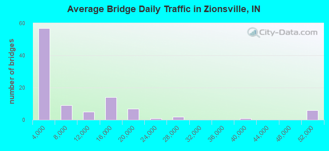
- 873,191Total average daily traffic
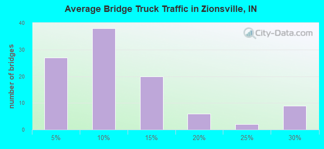
- 100,208Total average daily truck traffic
- National Bridge Inventory (NBI) Registered Bridges for Zionsville
- No street view available for this location
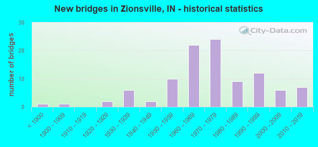
- New bridges - historical statistics
- 1Before 1900
- 11900-1909
- 21920-1929
- 61930-1939
- 21940-1949
- 101950-1959
- 221960-1969
- 241970-1979
- 91980-1989
- 121990-1999
- 62000-2009
- 72010-2019
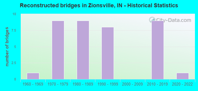
- Reconstructed bridges - Historical Statistics
- 11960-1969
- 91970-1979
- 91980-1989
- 81990-1999
- 02000-2009
- 92010-2019
- 12020-2022
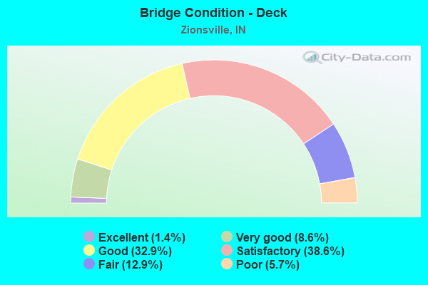
- Bridge Condition - Deck
- 1.4%Excellent
- 8.6%Very good
- 32.9%Good
- 38.6%Satisfactory
- 12.9%Fair
- 5.7%Poor
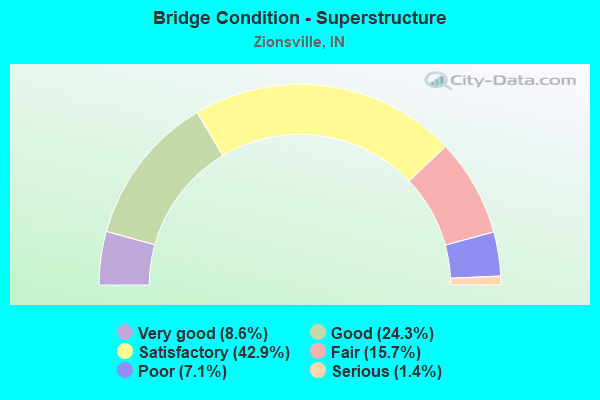
- Bridge Condition - Superstructure
- 8.6%Very good
- 24.3%Good
- 42.9%Satisfactory
- 15.7%Fair
- 7.1%Poor
- 1.4%Serious
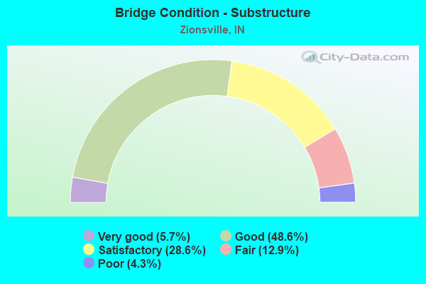
- Bridge Condition - Substructure
- 5.7%Very good
- 48.6%Good
- 28.6%Satisfactory
- 12.9%Fair
- 4.3%Poor
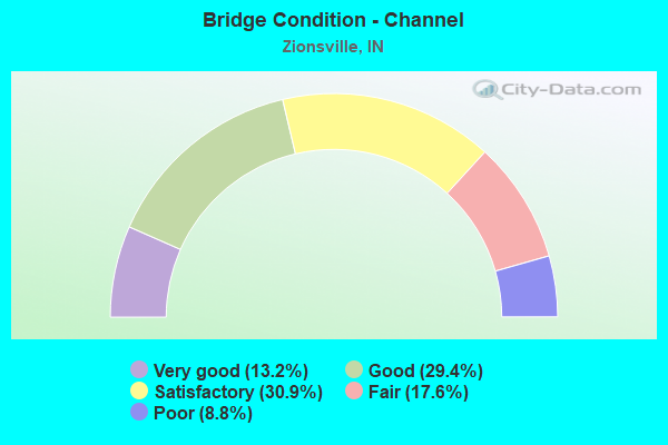
- Bridge Condition - Channel
- 13.2%Very good
- 29.4%Good
- 30.9%Satisfactory
- 17.6%Fair
- 8.8%Poor
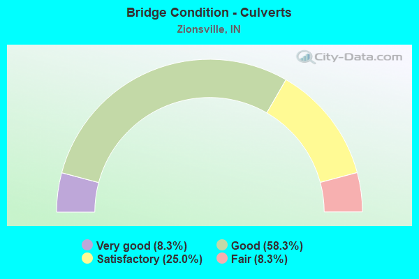
- Bridge Condition - Culverts
- 8.3%Very good
- 58.3%Good
- 25.0%Satisfactory
- 8.3%Fair
Find on map >> Show street view
Structure Number: 3200027, Location: 00.10 E OF CR 950 E (Lat: 39.902289, Lng: -86.351897), Route carried "on" structure: County highway 244, Year Built: 1935, Year Reconstructed: 1983, Status: Posted for load, Structure Length: 0.68m (2.23ft), Average Daily Traffic: 850 (year 2020), Truck Traffic: 8%, Average Future Daily Traffic: 1,400 (year 2040), Features Intersected: BATZ DRAIN, Facility Carried by Structure: CR 950N
Minimum Vertical Clearance: 30+ m (98+ ft), Kilometerpoint: 0.000, Lanes on structure: 2, Owner: County Highway Agency, Approaching Roadway Width: 5.5m (18.0ft), Skew: 4 degrees, Material/Design: Concrete, Design/Construction: Slab, Number Of Spans In Main Unit: 1, Length of Maximum Span: 6.5m (21.3ft), Curb-To-Curb Width: 6.3m (20.7ft), Out-to-Out Width: 7.3m (24.0ft)
Condition: Deck: Fair, Superstructure: Fair, Substructure: Fair, Channel: Satisfactory, Operating Rating: 13.6 metric tons, Method Used To Determine Operating Rating: Field evaluation and documented engineering judgment, Inventory Rating: 13.6 metric tons, Method Used To Determine Inventory Rating: Field evaluation and documented engineering judgment, Structural Evaluation: Meets minimum limits, Deck Geometry: High priority of corrective action, Waterway Adequacy: Equal to present minimum criteria, Approach Roadway Alignment: Equal to present desirable criteria, Bridge Posting: Required (Relationship of Operating Rating to Maximum Legal Load: > 39.9% below), Designated Inspection Frequency: Every 24 months, Inspection Date: June 2020, Deck Structure Type: Concrete Cast-file-Place, Wearing Surface/Protective System: Wearing Surface: Bituminous
Find on map >> Show street view
Structure Number: 3200224, Location: 00.60 W OF CR 950 E (Lat: 39.909389, Lng: -86.367011), Route carried "on" structure: County highway 1000, Year Built: 1991, Status: Open, Structure Length: 0.79m (2.59ft), Average Daily Traffic: 4,900 (year 2020), Truck Traffic: 14%, Average Future Daily Traffic: 6,225 (year 2040), Design Load: HS 20, Features Intersected: DUGAN DITCH
Minimum Vertical Clearance: 30+ m (98+ ft), Kilometerpoint: 0.000, Lanes on structure: 2, Owner: County Highway Agency, Approaching Roadway Width: 6.1m (20.0ft), Material/Design: Prestressed concrete, Design/Construction: Box Beam or Girders - Multiple, Number Of Spans In Main Unit: 1, Length of Maximum Span: 7.6m (24.9ft), Curb-To-Curb Width: 11.0m (36.1ft), Out-to-Out Width: 11.2m (36.7ft)
Condition: Deck: Poor, Superstructure: Poor, Substructure: Satisfactory, Channel: Satisfactory, Operating Rating: 73.0 metric tons, Method Used To Determine Operating Rating: Load Factor (LF), Inventory Rating: 43.7 metric tons, Method Used To Determine Inventory Rating: Load Factor (LF), Structural Evaluation: Meets minimum limits, Deck Geometry: Somewhat better than minimum adequacy, Waterway Adequacy: Better than present minimum criteria, Approach Roadway Alignment: Equal to present desirable criteria, Length Of Structure Improvement: 0.82m (2.69ft), Designated Inspection Frequency: Every 12 months, Inspection Date: May 2021, Bridge Improvement Cost: $100,000, Roadway Improvement Cost: $80,000, Total Project Cost: $180,000 ( Estimate for 2020), Deck Structure Type: Concrete Precast Panels, Wearing Surface/Protective System: Wearing Surface: Bituminous
Find on map >> Show street view
Structure Number: 3715, Location: 00.48 S I-865 (Lat: 39.925189, Lng: -86.334200), Route carried "under" structure: City street , Year Built: 1959, Structure Length: 0. m, Average Daily Traffic: 2,775 (year 2004), Truck Traffic: 5%, Features Intersected: LAFAYETTE ROAD NBL, Facility Carried by Structure: I-65 NB
Minimum Vertical Clearance: 5.03m (16.50ft), Kilometerpoint: 0.000, Lanes on structure: 2, Lanes under structure: 4, Material/Design: Steel continuous, Design/Construction: Stringer/Multi-beam, Length of Maximum Span: 23.8m (78.1ft)
Find on map >> Show street view
Structure Number: 3715, Location: 00.48 S I-865 (Lat: 39.925189, Lng: -86.334200), Route carried "under" structure: City street , Year Built: 1959, Structure Length: 0. m, Average Daily Traffic: 2,775 (year 2004), Truck Traffic: 5%, Features Intersected: LAFAYETTE ROAD SBL, Facility Carried by Structure: I-65 NB
Minimum Vertical Clearance: 5.03m (16.50ft), Kilometerpoint: 0.000, Lanes on structure: 2, Lanes under structure: 4, Material/Design: Steel continuous, Design/Construction: Stringer/Multi-beam, Length of Maximum Span: 23.8m (78.1ft)
Find on map >> Show street view
Structure Number: 3716, Location: 00.48 S I-865 (Lat: 39.925389, Lng: -86.334719), Route carried "under" structure: City street , Year Built: 1959, Structure Length: 0. m, Average Daily Traffic: 2,775 (year 2004), Truck Traffic: 5%, Features Intersected: LAFAYETTE ROAD NBL, Facility Carried by Structure: I-65 SB
Minimum Vertical Clearance: 4.60m (15.09ft), Kilometerpoint: 0.000, Lanes on structure: 2, Lanes under structure: 4, Material/Design: Steel continuous, Design/Construction: Stringer/Multi-beam, Length of Maximum Span: 23.8m (78.1ft)
Find on map >> Show street view
Structure Number: 3716, Location: 00.48 S I-865 (Lat: 39.925389, Lng: -86.334719), Route carried "under" structure: City street , Year Built: 1959, Structure Length: 0. m, Average Daily Traffic: 2,775 (year 2004), Truck Traffic: 5%, Features Intersected: LAFAYETTE ROAD SBL, Facility Carried by Structure: I-65 SB
Minimum Vertical Clearance: 4.60m (15.09ft), Kilometerpoint: 0.000, Lanes on structure: 2, Lanes under structure: 4, Material/Design: Steel continuous, Design/Construction: Stringer/Multi-beam, Length of Maximum Span: 23.8m (78.1ft)
Find on map >> Show street view
Structure Number: 506, Location: 01.71 W US 421 (Lat: 39.927750, Lng: -86.259869), Route carried "under" structure: City street , Year Built: 1967, Structure Length: 0. m, Average Daily Traffic: 710 (year 2004), Truck Traffic: 15%, Features Intersected: ZIONSVILLE ROAD, Facility Carried by Structure: I-465 EB
Minimum Vertical Clearance: 4.33m (14.21ft), Kilometerpoint: 0.000, Lanes on structure: 3, Lanes under structure: 2, Material/Design: Steel continuous, Design/Construction: Stringer/Multi-beam, Length of Maximum Span: 20.1m (65.9ft)
Find on map >> Show street view
Structure Number: 5061, Location: 01.71 W US 421 (Lat: 39.927989, Lng: -86.259861), Route carried "under" structure: City street , Year Built: 1967, Structure Length: 0. m, Average Daily Traffic: 710 (year 2004), Truck Traffic: 15%, Features Intersected: ZIONSVILLE ROAD, Facility Carried by Structure: I-465 WB
Minimum Vertical Clearance: 4.78m (15.68ft), Kilometerpoint: 0.000, Lanes on structure: 3, Lanes under structure: 2, Material/Design: Steel continuous, Design/Construction: Stringer/Multi-beam, Length of Maximum Span: 20.1m (65.9ft)
Find on map >> Show street view
Structure Number: 5062, Location: 01.97 W US 421 (Lat: 39.928989, Lng: -86.264339), Route carried "under" structure: Interstate 865, Year Built: 1967, Structure Length: 0. m, Average Daily Traffic: 11,495 (year 2010), Truck Traffic: 25%, Features Intersected: I-865 WB
Minimum Vertical Clearance: 4.60m (15.09ft), Kilometerpoint: 7.339, Lanes on structure: 1, Lanes under structure: 3, Material/Design: Steel continuous, Design/Construction: Stringer/Multi-beam, Length of Maximum Span: 16.3m (53.5ft)
Find on map >> Show street view
Structure Number: 5062, Location: 01.97 W US 421 (Lat: 39.928989, Lng: -86.264339), Route carried "under" structure: Interstate 865, Year Built: 1967, Structure Length: 0. m, Average Daily Traffic: 11,495 (year 2010), Truck Traffic: 25%, Features Intersected: I-865 EB
Minimum Vertical Clearance: 4.60m (15.09ft), Kilometerpoint: 7.339, Lanes on structure: 1, Lanes under structure: 3, Material/Design: Steel continuous, Design/Construction: Stringer/Multi-beam, Length of Maximum Span: 16.3m (53.5ft)
Find on map >> Show street view
Structure Number: 5063, Location: 02.19 W US 421 (Lat: 39.929969, Lng: -86.268081), Route carried "under" structure: Interstate 865, Year Built: 1967, Structure Length: 0. m, Average Daily Traffic: 13,939 (year 2014), Truck Traffic: 5%, Features Intersected: I-865 WBL & WB RAMP, Facility Carried by Structure: I-465 WB TO I-465
Minimum Vertical Clearance: 4.37m (14.34ft), Kilometerpoint: 6.985, Lanes on structure: 2, Lanes under structure: 5, Material/Design: Steel continuous, Design/Construction: Stringer/Multi-beam, Length of Maximum Span: 22.7m (74.5ft)
Find on map >> Show street view
Structure Number: 5063, Location: 02.19 W US 421 (Lat: 39.929969, Lng: -86.268081), Route carried "under" structure: Interstate 865, Year Built: 1967, Structure Length: 0. m, Average Daily Traffic: 13,939 (year 2014), Truck Traffic: 5%, Features Intersected: I-865 EBL, Facility Carried by Structure: I-465 WB TO I-465
Minimum Vertical Clearance: 4.70m (15.42ft), Kilometerpoint: 6.985, Lanes on structure: 2, Lanes under structure: 5, Material/Design: Steel continuous, Design/Construction: Stringer/Multi-beam, Length of Maximum Span: 22.7m (74.5ft)
Find on map >> Show street view
Structure Number: 5064, Location: 04.40 N I-65 (Lat: 39.924950, Lng: -86.267900), Route carried "under" structure: City street , Year Built: 1968, Structure Length: 0. m, Average Daily Traffic: 928 (year 2004), Truck Traffic: 5%, Features Intersected: 96TH ST EB & WB, Facility Carried by Structure: I-465 NB
Minimum Vertical Clearance: 4.50m (14.76ft), Kilometerpoint: 0.000, Lanes on structure: 3, Lanes under structure: 2, Material/Design: Concrete continuous, Design/Construction: Slab, Length of Maximum Span: 12.2m (40.0ft)
Find on map >> Show street view
Structure Number: 5065, Location: 04.40 N I-65 (Lat: 39.924939, Lng: -86.268269), Route carried "under" structure: City street , Year Built: 1968, Structure Length: 0. m, Average Daily Traffic: 928 (year 2004), Truck Traffic: 5%, Features Intersected: 96TH ST EB & WB, Facility Carried by Structure: I-465 SB
Minimum Vertical Clearance: 4.44m (14.57ft), Kilometerpoint: 0.000, Lanes on structure: 3, Lanes under structure: 2, Material/Design: Concrete continuous, Design/Construction: Slab, Length of Maximum Span: 11.8m (38.7ft)
Find on map >> Show street view
Structure Number: 5123, Location: 00.54 E I-65 (Lat: 39.931089, Lng: -86.339289), Route carried "under" structure: Interstate 65, Year Built: 1971, Structure Length: 0. m, Average Daily Traffic: 26,336 (year 2004), Truck Traffic: 5%, Features Intersected: I65 SB
Minimum Vertical Clearance: 4.88m (16.01ft), Kilometerpoint: 206.785, Lanes on structure: 2, Lanes under structure: 4, Material/Design: Steel continuous, Design/Construction: Stringer/Multi-beam, Length of Maximum Span: 24.7m (81.0ft)
Find on map >> Show street view
Structure Number: 5123, Location: 00.54 E I-65 (Lat: 39.931089, Lng: -86.339289), Route carried "under" structure: Interstate 65, Year Built: 1971, Structure Length: 0. m, Average Daily Traffic: 26,336 (year 2004), Truck Traffic: 5%, Features Intersected: I65 NB
Minimum Vertical Clearance: 4.98m (16.34ft), Kilometerpoint: 206.785, Lanes on structure: 2, Lanes under structure: 4, Material/Design: Steel continuous, Design/Construction: Stringer/Multi-beam, Length of Maximum Span: 24.7m (81.0ft)
Find on map >> Show street view
Structure Number: 5126, Location: 01.50 E I-65 (Lat: 39.931700, Lng: -86.321400), Route carried "under" structure: Interstate 865, Year Built: 1971, Structure Length: 0. m, Average Daily Traffic: 13,744 (year 2010), Truck Traffic: 15%, Features Intersected: I-865 EB, Facility Carried by Structure: KISSEL ROAD
Minimum Vertical Clearance: 4.88m (16.01ft), Kilometerpoint: 2.414, Lanes on structure: 2, Lanes under structure: 4, Material/Design: Concrete continuous, Design/Construction: Stringer/Multi-beam, Length of Maximum Span: 20.0m (65.6ft)
Find on map >> Show street view
Structure Number: 5126, Location: 01.50 E I-65 (Lat: 39.931700, Lng: -86.321400), Route carried "under" structure: Interstate 865, Year Built: 1971, Structure Length: 0. m, Average Daily Traffic: 13,744 (year 2010), Truck Traffic: 15%, Features Intersected: I-865 WB, Facility Carried by Structure: KISSEL ROAD
Minimum Vertical Clearance: 4.78m (15.68ft), Kilometerpoint: 2.414, Lanes on structure: 2, Lanes under structure: 4, Material/Design: Concrete continuous, Design/Construction: Stringer/Multi-beam, Length of Maximum Span: 20.0m (65.6ft)
Find on map >> Show street view
Structure Number: 5127, Location: 02.25 E I-65 (Lat: 39.931450, Lng: -86.307250), Route carried "under" structure: Interstate 865, Year Built: 1971, Structure Length: 0. m, Average Daily Traffic: 13,744 (year 2010), Truck Traffic: 15%, Features Intersected: I-865 EB, Facility Carried by Structure: COOPER ROAD
Minimum Vertical Clearance: 4.78m (15.68ft), Kilometerpoint: 3.621, Lanes on structure: 2, Lanes under structure: 4, Material/Design: Concrete continuous, Design/Construction: Stringer/Multi-beam, Length of Maximum Span: 20.0m (65.6ft)
Find on map >> Show street view
Structure Number: 5127, Location: 02.25 E I-65 (Lat: 39.931450, Lng: -86.307250), Route carried "under" structure: Interstate 865, Year Built: 1971, Structure Length: 0. m, Average Daily Traffic: 13,744 (year 2010), Truck Traffic: 15%, Features Intersected: I-865 WB, Facility Carried by Structure: COOPER ROAD
Minimum Vertical Clearance: 4.75m (15.58ft), Kilometerpoint: 3.621, Lanes on structure: 2, Lanes under structure: 4, Material/Design: Concrete continuous, Design/Construction: Stringer/Multi-beam, Length of Maximum Span: 20.0m (65.6ft)
Find on map >> Show street view
Structure Number: 513, Location: 03.77 E I-65 (Lat: 39.930761, Lng: -86.278831), Route carried "under" structure: Interstate 865, Year Built: 1971, Structure Length: 0. m, Average Daily Traffic: 13,205 (year 2010), Truck Traffic: 23%, Features Intersected: I-865 EB, Facility Carried by Structure: FORD ROAD
Minimum Vertical Clearance: 4.72m (15.49ft), Kilometerpoint: 6.067, Lanes on structure: 2, Lanes under structure: 4, Material/Design: Concrete continuous, Design/Construction: Stringer/Multi-beam, Length of Maximum Span: 20.0m (65.6ft)
Find on map >> Show street view
Structure Number: 513, Location: 03.77 E I-65 (Lat: 39.930761, Lng: -86.278831), Route carried "under" structure: Interstate 865, Year Built: 1971, Structure Length: 0. m, Average Daily Traffic: 13,205 (year 2010), Truck Traffic: 23%, Features Intersected: I-865 WB, Facility Carried by Structure: FORD ROAD
Minimum Vertical Clearance: 4.67m (15.32ft), Kilometerpoint: 6.067, Lanes on structure: 2, Lanes under structure: 4, Material/Design: Concrete continuous, Design/Construction: Stringer/Multi-beam, Length of Maximum Span: 20.0m (65.6ft)