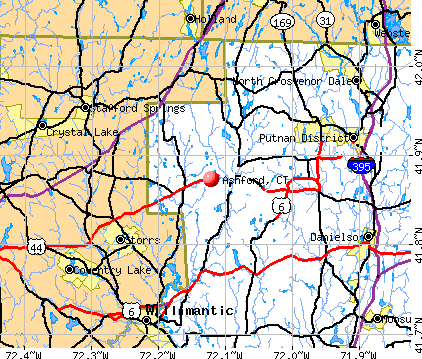
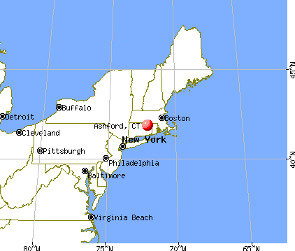
Ashford, Connecticut
Submit your own pictures of this town and show them to the world
- OSM Map
- General Map
- Google Map
- MSN Map
Population change since 2000: +5.3%
 |
| Males: 2,129 | |
| Females: 2,188 |
| Median resident age: | 42.1 years |
| Connecticut median age: | 39.2 years |
Zip codes: 06278.
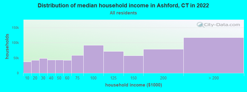
| Ashford: | $90,175 |
| CT: | $88,429 |
Estimated per capita income in 2022: $46,808 (it was $26,104 in 2000)
Ashford town income, earnings, and wages data
Estimated median house or condo value in 2022: $302,665 (it was $140,000 in 2000)
| Ashford: | $302,665 |
| CT: | $347,200 |
Mean prices in 2022: all housing units: $270,250; detached houses: $283,786; townhouses or other attached units: $235,819; in 2-unit structures: $159,195; in 3-to-4-unit structures: $165,857; in 5-or-more-unit structures: $105,814; mobile homes: $180,020
Detailed information about poverty and poor residents in Ashford, CT


- 3,97792.1%White alone
- 1523.5%Hispanic
- 751.7%Two or more races
- 571.3%Asian alone
- 431.0%Black alone
- 110.3%American Indian alone
- 10.02%Native Hawaiian and Other
Pacific Islander alone - 10.02%Other race alone
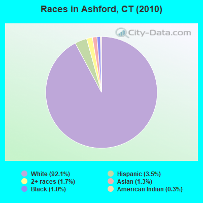
Races in Ashford detailed stats: ancestries, foreign born residents, place of birth
According to our research of Connecticut and other state lists, there were 3 registered sex offenders living in Ashford, Connecticut as of May 21, 2024.
The ratio of all residents to sex offenders in Ashford is 1,439 to 1.
The ratio of registered sex offenders to all residents in this city is lower than the state average.
 Recent articles from our blog. Our writers, many of them Ph.D. graduates or candidates, create easy-to-read articles on a wide variety of topics.


 | 2024 Connecticut Town Tournament VI (Celebrating the 10-Year Anniversary & Dazzleman's Memorial) (998 replies) |
| Economic Climate in CT (18750 replies) |
| Desegregate Connecticut---Raised CT Zoning Bill (2519 replies) |
| Connecticut TOWN TOURNAMENT V (2022) (831 replies) |
| I unfortunately see why so many people move (124 replies) |
| Crumbling Foundations (98 replies) |
Latest news from Ashford, CT collected exclusively by city-data.com from local newspapers, TV, and radio stations
Ashford, CT City Guides:
Ancestries: Irish (18.7%), Italian (15.7%), German (14.0%), French (13.2%), English (11.8%), Polish (9.1%).
Current Local Time: EST time zone
Incorporated on 10/1714
Elevation: 700 feet
Land area: 38.8 square miles.
Population density: 111 people per square mile (very low).
173 residents are foreign born (3.3% Europe, 0.4% North America).
| This town: | 4.2% |
| Connecticut: | 10.9% |
| Ashford town: | 1.7% ($2,426) |
| Connecticut: | 1.8% ($2,961) |
Nearest city with pop. 50,000+: Manchester, CT  (19.6 miles , pop. 54,740).
Nearest city with pop. 200,000+: Boston, MA (63.1 miles , pop. 589,141).
Nearest city with pop. 1,000,000+: Bronx, NY (114.1 miles , pop. 1,332,650).
Nearest cities:
), ), Latitude: 41.90 N, Longitude: 72.18 W
Area code commonly used in this area: 860

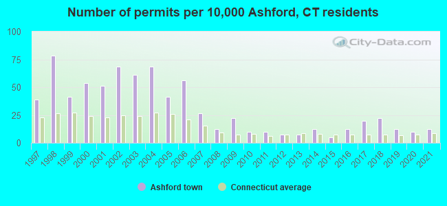
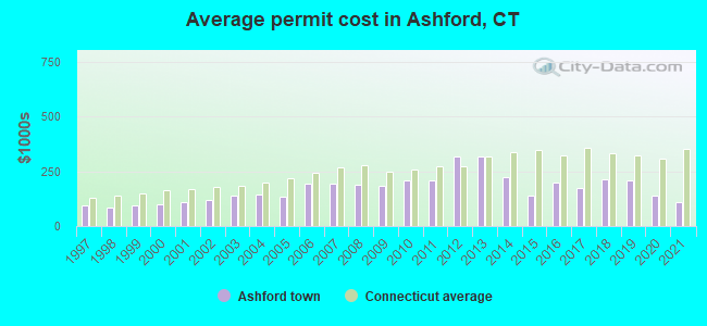
Single-family new house construction building permits:
- 2021: 5 buildings, average cost: $110,400
- 2020: 4 buildings, average cost: $140,500
- 2019: 5 buildings, average cost: $210,900
- 2018: 9 buildings, average cost: $216,100
- 2017: 8 buildings, average cost: $174,400
- 2016: 5 buildings, average cost: $201,000
- 2015: 2 buildings, average cost: $140,800
- 2014: 5 buildings, average cost: $224,400
- 2013: 3 buildings, average cost: $320,000
- 2012: 3 buildings, average cost: $316,700
- 2011: 4 buildings, average cost: $210,800
- 2010: 4 buildings, average cost: $206,500
- 2009: 9 buildings, average cost: $185,400
- 2008: 5 buildings, average cost: $190,600
- 2007: 11 buildings, average cost: $194,600
- 2006: 23 buildings, average cost: $191,700
- 2005: 17 buildings, average cost: $136,100
- 2004: 28 buildings, average cost: $142,700
- 2003: 25 buildings, average cost: $141,100
- 2002: 28 buildings, average cost: $119,600
- 2001: 21 buildings, average cost: $111,000
- 2000: 22 buildings, average cost: $97,400
- 1999: 17 buildings, average cost: $95,600
- 1998: 32 buildings, average cost: $84,600
- 1997: 16 buildings, average cost: $92,300
| Here: | 2.6% |
| Connecticut: | 3.9% |
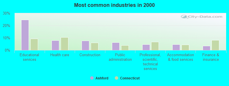
- Educational services (24.6%)
- Health care (8.0%)
- Construction (7.7%)
- Public administration (6.3%)
- Professional, scientific, technical services (4.7%)
- Accommodation & food services (4.6%)
- Finance & insurance (3.4%)

- Educational services (17.4%)
- Construction (13.8%)
- Public administration (8.6%)
- Professional, scientific, technical services (5.1%)
- Finance & insurance (4.5%)
- Administrative & support & waste management services (3.9%)
- Health care (3.5%)
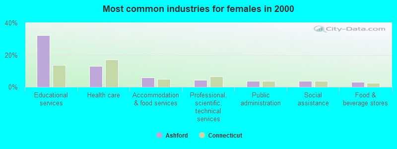
- Educational services (32.2%)
- Health care (12.9%)
- Accommodation & food services (5.8%)
- Professional, scientific, technical services (4.4%)
- Public administration (3.7%)
- Social assistance (3.7%)
- Food & beverage stores (3.1%)

- Other management occupations, except farmers and farm managers (5.8%)
- Postsecondary teachers (4.4%)
- Material recording, scheduling, dispatching, and distributing workers (4.1%)
- Building and grounds cleaning and maintenance occupations (3.9%)
- Other sales and related occupations, including supervisors (3.7%)
- Computer specialists (3.2%)
- Preschool, kindergarten, elementary, and middle school teachers (2.9%)
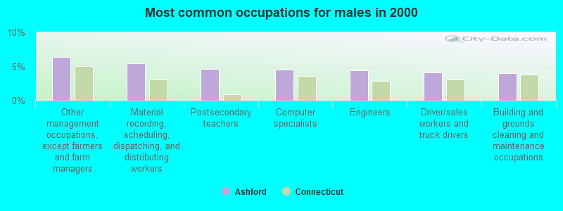
- Other management occupations, except farmers and farm managers (6.4%)
- Material recording, scheduling, dispatching, and distributing workers (5.4%)
- Postsecondary teachers (4.7%)
- Computer specialists (4.6%)
- Engineers (4.4%)
- Driver/sales workers and truck drivers (4.1%)
- Building and grounds cleaning and maintenance occupations (4.1%)

- Preschool, kindergarten, elementary, and middle school teachers (5.4%)
- Other office and administrative support workers, including supervisors (5.3%)
- Other management occupations, except farmers and farm managers (5.2%)
- Other sales and related occupations, including supervisors (4.4%)
- Postsecondary teachers (4.1%)
- Secretaries and administrative assistants (4.0%)
- Other teachers, instructors, education, training, and library occupations (4.0%)
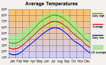
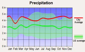
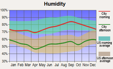
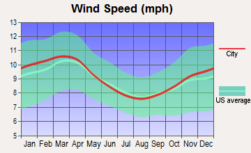
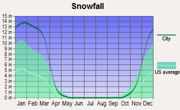
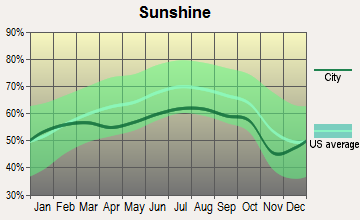
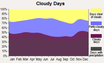
Average climate in Ashford, Connecticut
Based on data reported by over 4,000 weather stations
(lower is better)
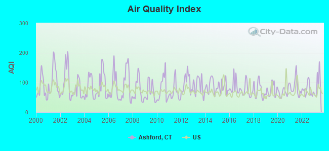
Air Quality Index (AQI) level in 2023 was 93.1. This is worse than average.
| City: | 93.1 |
| U.S.: | 72.6 |
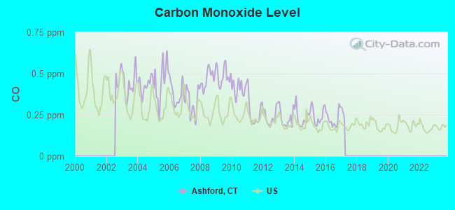
Carbon Monoxide (CO) [ppm] level in 2016 was 0.226. This is about average. Closest monitor was 21.5 miles away from the city center.
| City: | 0.226 |
| U.S.: | 0.251 |
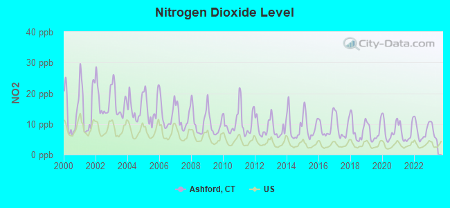
Nitrogen Dioxide (NO2) [ppb] level in 2022 was 7.64. This is significantly worse than average. Closest monitor was 6.8 miles away from the city center.
| City: | 7.64 |
| U.S.: | 5.11 |
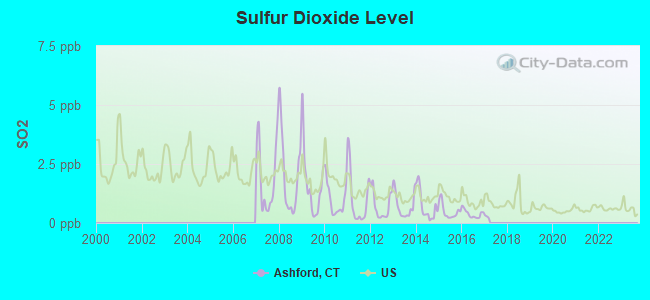
Sulfur Dioxide (SO2) [ppb] level in 2016 was 0.389. This is significantly better than average. Closest monitor was 6.4 miles away from the city center.
| City: | 0.389 |
| U.S.: | 1.515 |
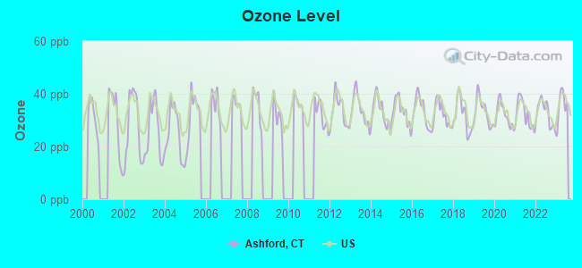
Ozone [ppb] level in 2023 was 35.6. This is about average. Closest monitor was 6.0 miles away from the city center.
| City: | 35.6 |
| U.S.: | 33.3 |
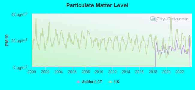
Particulate Matter (PM10) [µg/m3] level in 2022 was 13.1. This is significantly better than average. Closest monitor was 13.8 miles away from the city center.
| City: | 13.1 |
| U.S.: | 19.2 |
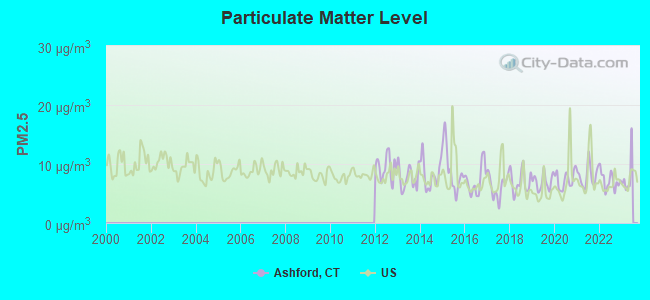
Particulate Matter (PM2.5) [µg/m3] level in 2022 was 7.16. This is about average. Closest monitor was 24.7 miles away from the city center.
| City: | 7.16 |
| U.S.: | 8.11 |
Tornado activity:
Ashford-area historical tornado activity is slightly above Connecticut state average. It is 22% smaller than the overall U.S. average.
On 10/3/1979, a category F4 (max. wind speeds 207-260 mph) tornado 25.4 miles away from the Ashford town center killed 3 people and injured 500 people and caused between $50,000,000 and $500,000,000 in damages.
On 5/10/1954, a category F3 (max. wind speeds 158-206 mph) tornado 15.2 miles away from the town center injured 2 people and caused between $5000 and $50,000 in damages.
Earthquake activity:
Ashford-area historical earthquake activity is significantly above Connecticut state average. It is 71% smaller than the overall U.S. average.On 10/7/1983 at 10:18:46, a magnitude 5.3 (5.1 MB, 5.3 LG, 5.1 ML, Class: Moderate, Intensity: VI - VII) earthquake occurred 179.7 miles away from the city center
On 4/20/2002 at 10:50:47, a magnitude 5.3 (5.3 ML, Depth: 3.0 mi) earthquake occurred 196.6 miles away from Ashford center
On 4/20/2002 at 10:50:47, a magnitude 5.2 (5.2 MB, 4.2 MS, 5.2 MW, 5.0 MW) earthquake occurred 195.4 miles away from the city center
On 1/19/1982 at 00:14:42, a magnitude 4.7 (4.5 MB, 4.7 MD, 4.5 LG, Class: Light, Intensity: IV - V) earthquake occurred 114.8 miles away from the city center
On 10/16/2012 at 23:12:25, a magnitude 4.7 (4.7 ML, Depth: 10.0 mi) earthquake occurred 140.8 miles away from Ashford center
On 8/22/1992 at 12:20:32, a magnitude 4.8 (4.8 MB, 3.8 MS, 4.7 LG, Depth: 6.2 mi) earthquake occurred 216.2 miles away from the city center
Magnitude types: regional Lg-wave magnitude (LG), body-wave magnitude (MB), duration magnitude (MD), local magnitude (ML), surface-wave magnitude (MS), moment magnitude (MW)
Natural disasters:
The number of natural disasters in Windham County (24) is greater than the US average (15).Major Disasters (Presidential) Declared: 13
Emergencies Declared: 11
Causes of natural disasters: Hurricanes: 6, Storms: 6, Floods: 4, Snowstorms: 4, Blizzards: 3, Snows: 3, Winter Storms: 3, Snowfall: 1, Tropical Storm: 1, Wind: 1, Other: 1 (Note: some incidents may be assigned to more than one category).
Hospitals and medical centers near Ashford:
- T R I-COUNTY ARC: DUNN HILL (Hospital, about 11 miles away; TOLLAND, CT)
- NATCHAUG HOSPITAL (Hospital, about 11 miles away; MANSFIELD CENTER, CT)
- VNA EAST INC (Home Health Center, about 12 miles away; MANSFIELD CENTER, CT)
- VISITING NRS AND COMM HEALTH OF (Hospital, about 12 miles away; MANSFIELD CENTER, CT)
- WOODLAKE AT TOLLAND (Nursing Home, about 13 miles away; TOLLAND, CT)
- ST JOSEPHS LIVING CENTER (Nursing Home, about 13 miles away; WINDHAM, CT)
- JOHNSON MEMORIAL HOSPITAL Acute Care Hospitals (about 13 miles away; STAFFORD SPRINGS, CT)
Airports located in Ashford:
- Westford Airstrip Airport (CT74) (Runways: 1)
Colleges/universities with over 2000 students nearest to Ashford:
- University of Connecticut (about 8 miles; Storrs, CT; Full-time enrollment: 22,037)
- Eastern Connecticut State University (about 13 miles; Willimantic, CT; FT enrollment: 4,985)
- Manchester Community College (about 22 miles; Manchester, CT; FT enrollment: 4,667)
- Western New England University (about 24 miles; Springfield, MA; FT enrollment: 3,477)
- Bay Path College (about 24 miles; Longmeadow, MA; FT enrollment: 2,085)
- Springfield College (about 25 miles; Springfield, MA; FT enrollment: 3,144)
- American International College (about 25 miles; Springfield, MA; FT enrollment: 2,733)
Public elementary/middle school in Ashford:
- ASHFORD SCHOOL (Students: 556, Location: 440 WESTFORD ROAD, Grades: PK-8)
Points of interest:
Notable locations in Ashford: Brialee Campground (A), Camp Connri (B), June Norcross Webster Scout Reservation (C), Hole in the Wall Gang Paul Newman Camp (D), Church Farm Homestead (E), Ashford Volunteer Fire Department Station 220 (F), Ashford Volunteer Fire Department Station 20 (G), Earl W Smith Senior Center (H), Babcock Library (I). Display/hide their locations on the map
Churches in Ashford include: Westford Hill Church (A), Saint Philip-Apostle Church (B), Westford Congregational Church (C). Display/hide their locations on the map
Cemeteries: Westford Hill Cemetery (1), Warrenville Cemetery (2), Ward Cemetery (3), Swamp Burying Ground (4), South Ashford Cemetery (5), Babcock Cemetery (6), Westford Village Cemetery (7). Display/hide their locations on the map
Lakes, reservoirs, and swamps: Stowell Pond (A), Leander Pond (B), Poole Pond (C), Armitage Pond (D), Ashford Lake (E), Paine Pond (F), Goss Pond (G), Sabo Pond (H). Display/hide their locations on the map
Streams, rivers, and creeks: Lowry Brook (A), Moritz Brook (B), North Chism Brook (C), South Chism Brook (D), Squaw Hollow Brook (E), Lipps Brook (F), Basset Brook (G), Bebbington Brook (H), Boston Hollow Road Brook (I). Display/hide their locations on the map
Parks in Ashford include: Tinkerville Brook Preserve (1), Pompey Hollow Park (2). Display/hide their locations on the map
Tourist attraction: McCaughtry & Associates (Cultural Attractions- Events- & Facilities; 44 Portland Drive) (1). Display/hide its approximate location on the map
Hotel: Ashford Motel (26 Ashford Motel Road) (1). Display/hide its approximate location on the map
Court: Ashford Town - Administrative Departments- Probate Court (20 Pompey Hollow Road) (1). Display/hide its approximate location on the map
Birthplace of: Comfort Tyler - Pioneer, Nathaniel Lyon - Army general, Galusha A. Grow - Pennsylvania politician, John H. Trumbull - Politician, Walter Eli Clark - (Rep.) 1912-1913.
Drinking water stations with addresses in Ashford and their reported violations in the past:
EVANGELICAL CHRISTIAN CENTER - MAIN (Population served: 84, Groundwater):Past health violations:MEADOWBROOK APARTMENTS, LLC (Population served: 60, Groundwater):Past monitoring violations:
- MCL, Monthly (TCR) - In NOV-2011, Contaminant: Coliform. Follow-up actions: St Public Notif requested (DEC-16-2011), St Violation/Reminder Notice (DEC-16-2011), St Public Notif received (DEC-22-2011), St Compliance achieved (DEC-31-2011)
- MCL, Monthly (TCR) - In SEP-2010, Contaminant: Coliform. Follow-up actions: St Public Notif requested (SEP-28-2010), St Violation/Reminder Notice (SEP-28-2010), St Public Notif received (OCT-13-2010), St Compliance achieved (OCT-31-2010)
- MCL, Monthly (TCR) - In AUG-2007, Contaminant: Coliform. Follow-up actions: St BCA signed (MAY-18-2007), St Public Notif requested (AUG-15-2007), St Violation/Reminder Notice (AUG-15-2007), St Public Notif received (AUG-23-2007), St Compliance achieved (MAR-31-2008)
- MCL, Monthly (TCR) - In JAN-2007, Contaminant: Coliform. Follow-up actions: St Public Notif requested (JAN-17-2007), St Violation/Reminder Notice (JAN-17-2007), St Public Notif received (JAN-22-2007), St BCA signed (MAY-18-2007), St Compliance achieved (MAR-31-2008)
- MCL, Acute (TCR) - In JAN-2007, Contaminant: Coliform. Follow-up actions: St Public Notif requested (JAN-17-2007), St Violation/Reminder Notice (JAN-17-2007), St Public Notif received (JAN-22-2007), St BCA signed (MAY-18-2007), St Compliance achieved (MAR-31-2008)
- MCL, Monthly (TCR) - In OCT-2005, Contaminant: Coliform. Follow-up actions: St Public Notif requested (OCT-25-2005), St Violation/Reminder Notice (OCT-25-2005), St Compliance achieved (JUN-30-2006), St BCA signed (MAY-18-2007)
- MCL, Monthly (TCR) - In AUG-2005, Contaminant: Coliform. Follow-up actions: St Public Notif requested (AUG-25-2005), St Violation/Reminder Notice (AUG-25-2005), St Public Notif received (OCT-20-2005), St Compliance achieved (JUN-30-2006), St BCA signed (MAY-18-2007)
- Monitoring, Repeat Major (TCR) - In OCT-2008, Contaminant: Coliform (TCR). Follow-up actions: St Compliance achieved (NOV-30-2008), St Public Notif requested (JAN-13-2009), St Violation/Reminder Notice (JAN-13-2009)
- Monitoring and Reporting (DBP) - Between JUL-2007 and SEP-2007, Contaminant: Chlorine. Follow-up actions: St Violation/Reminder Notice (NOV-29-2007), St Compliance achieved (DEC-04-2007), St Public Notif received (MAR-09-2009)
- Monitoring, Repeat Major (TCR) - In DEC-2006, Contaminant: Coliform (TCR). Follow-up actions: St Public Notif requested (MAY-17-2007), St Public Notif received (JUN-06-2007), St Compliance achieved (MAR-31-2008)
- One routine major monitoring violation
Past health violations:MAR-LEA PARK APTS (Population served: 42, Groundwater):Past monitoring violations:
- OCCT/SOWT Study/Recommendation - In APR-01-2014, Contaminant: Lead and Copper Rule. Follow-up actions: St Violation/Reminder Notice (SEP-04-2014), St Public Notif requested (SEP-04-2014)
- Public Education - In DEC-01-2013, Contaminant: Lead and Copper Rule. Follow-up actions: St Violation/Reminder Notice (SEP-04-2014), St Public Notif requested (SEP-04-2014)
- Initial, Follow-up, or Routine Source Water M/R - In APR-01-2014, Contaminant: Lead and Copper Rule. Follow-up actions: St Violation/Reminder Notice (SEP-04-2014), St Public Notif requested (SEP-04-2014)
- 2 routine major monitoring violations
Past health violations:HEBRON ARMS APARTMENTS (Population served: 39, Groundwater):Past monitoring violations:
- Public Education - In OCT-27-2009, Contaminant: Lead and Copper Rule. Follow-up actions: St Violation/Reminder Notice (APR-14-2010)
- 15 regular monitoring violations
Past health violations:WESTFORD CONGREGATIONAL CHURCH (Population served: 25, Groundwater):Past monitoring violations:
- MCL, Monthly (TCR) - Between JUL-2006 and SEP-2006, Contaminant: Coliform. Follow-up actions: St Public Notif requested (OCT-26-2006), St Violation/Reminder Notice (OCT-26-2006), St Compliance achieved (MAR-31-2007)
- 3 regular monitoring violations
Past monitoring violations:
- 2 routine major monitoring violations
| This town: | 2.5 people |
| Connecticut: | 2.5 people |
| This town: | 68.2% |
| Whole state: | 66.3% |
| This town: | 9.1% |
| Whole state: | 6.6% |
Likely homosexual households (counted as self-reported same-sex unmarried-partner households)
- Lesbian couples: 1.3% of all households
- Gay men: 0.4% of all households
| This town: | 5.9% |
| Whole state: | 7.9% |
| This town: | 2.2% |
| Whole state: | 3.9% |
3 people in other noninstitutional facilities in 2010
16 people in nursing homes in 2000
For population 15 years and over in Ashford:
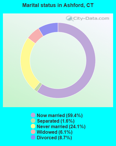
- Never married: 24.1%
- Now married: 59.4%
- Separated: 1.6%
- Widowed: 6.1%
- Divorced: 8.7%
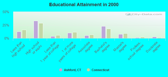
For population 25 years and over in Ashford:
- High school or higher: 87.2%
- Bachelor's degree or higher: 34.8%
- Graduate or professional degree: 12.1%
- Unemployed: 2.2%
- Mean travel time to work (commute): 30.4 minutes
| Here: | 11.8 |
| Connecticut average: | 12.8 |
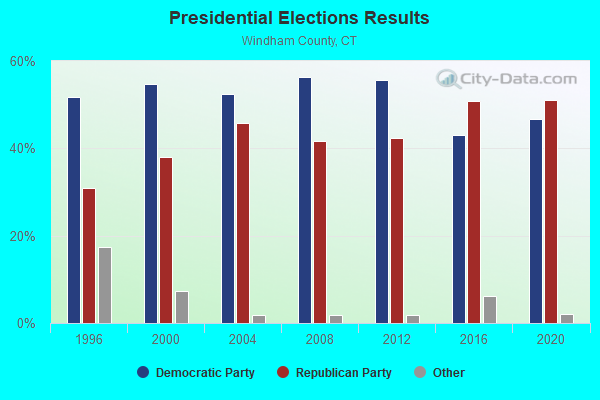
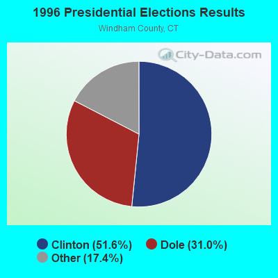
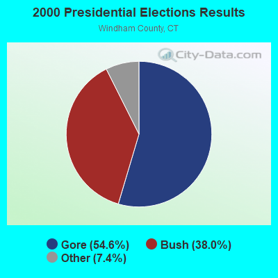
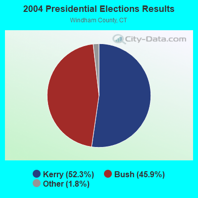
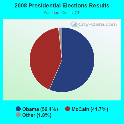

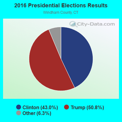
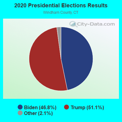
Graphs represent county-level data. Detailed 2008 Election Results
Religion statistics for Ashford, CT (based on Windham County data)
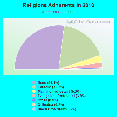
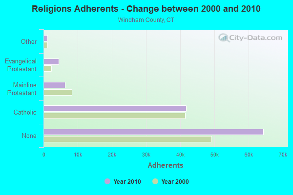
| Religion | Adherents | Congregations |
|---|---|---|
| Catholic | 41,700 | 18 |
| Mainline Protestant | 6,330 | 39 |
| Evangelical Protestant | 4,495 | 37 |
| Other | 1,119 | 12 |
| Orthodox | 205 | 2 |
| Black Protestant | 180 | 1 |
| None | 64,399 | - |
Food Environment Statistics:
| Windham County: | 1.63 / 10,000 pop. |
| Connecticut: | 2.21 / 10,000 pop. |
| This county: | 0.17 / 10,000 pop. |
| State: | 0.07 / 10,000 pop. |
| Windham County: | 1.11 / 10,000 pop. |
| Connecticut: | 1.02 / 10,000 pop. |
| Windham County: | 3.08 / 10,000 pop. |
| State: | 2.27 / 10,000 pop. |
| Here: | 6.76 / 10,000 pop. |
| State: | 9.19 / 10,000 pop. |
| This county: | 8.0% |
| Connecticut: | 7.3% |
| Windham County: | 26.6% |
| Connecticut: | 21.5% |
| This county: | 18.7% |
| State: | 15.8% |
Businesses in Ashford, CT
- Dunkin Donuts: 1
Strongest AM radio stations in Ashford:
- WCRN (830 AM; 50 kW; WORCESTER, MA; Owner: CARTER BROADCASTING CORPORATION)
- WNNZ (640 AM; 50 kW; WESTFIELD, MA; Owner: CLEAR CHANNEL BROADCASTING LICENSES, INC.)
- WALE (990 AM; 50 kW; GREENVILLE, RI; Owner: NORTH AMERICAN BROADCASTING CO., INC.)
- WVNE (760 AM; daytime; 25 kW; LEICESTER, MA; Owner: BLOUNT MASSCOM, INC.)
- WTIC (1080 AM; 50 kW; HARTFORD, CT; Owner: INFINITY RADIO OPERATIONS INC.)
- WEEI (850 AM; 50 kW; BOSTON, MA; Owner: ENTERCOM BOSTON LICENSE, LLC)
- WKOX (1200 AM; 50 kW; FRAMINGHAM, MA; Owner: CAPSTAR TX LIMITED PARTNERSHIP)
- WINY (1350 AM; 5 kW; PUTNAM, CT; Owner: OSBREY BROADCASTING COMPANY)
- WBIX (1060 AM; 40 kW; NATICK, MA; Owner: LANGER BROADCASTING CORPORATION)
- WRKO (680 AM; 50 kW; BOSTON, MA; Owner: ENTERCOM BOSTON LICENSE, LLC)
- WAMG (890 AM; 25 kW; DEDHAM, MA; Owner: MEGA COMMUNICATIONS OF DEDHAM LICENSEE, LLC)
- WBZ (1030 AM; 50 kW; BOSTON, MA; Owner: INFINITY BROADCASTING OPERATIONS, INC.)
- WWZN (1510 AM; 50 kW; BOSTON, MA; Owner: ROSE CITY RADIO CORPORATION)
Strongest FM radio stations in Ashford:
- WHUS (91.7 FM; STORRS, CT; Owner: THE BD. OF TRUSTEES, THE UNIV. OF CT)
- W258AC (99.5 FM; STORRS, CT; Owner: CONNECTICUT PUBLIC BROADCASTING, INC)
- WILI-FM (98.3 FM; WILLIMANTIC, CT; Owner: NUTMEG BROADCASTING COMPANY)
- WWFX (100.1 FM; SOUTHBRIDGE, MA; Owner: CITADEL BROADCASTING COMPANY)
- WORC-FM (98.9 FM; WEBSTER, MA; Owner: CITADEL BROADCASTING COMPANY)
- WBVC (91.1 FM; POMFRET, CT; Owner: POMFRET SCHOOL)
- WAAF (107.3 FM; WORCESTER, MA; Owner: ENTERCOM BOSTON LICENSE, LLC)
- WECS (90.1 FM; WILLIMANTIC, CT; Owner: EASTERN CONNECTICUT STATE COLLEGE)
- WRCH (100.5 FM; NEW BRITAIN, CT; Owner: INFINITY RADIO OPERATIONS INC.)
- WHYN-FM (93.1 FM; SPRINGFIELD, MA; Owner: CLEAR CHANNEL BROADCASTING LICENSES, INC.)
- WSRS (96.1 FM; WORCESTER, MA; Owner: CAPSTAR TX LIMITED PARTNERSHIP)
- WFCR (88.5 FM; AMHERST, MA; Owner: UNIVERSITY OF MASSACHUSETTS)
- WAQY (102.1 FM; SPRINGFIELD, MA; Owner: SAGA COMMUNICATIONS OF NEW ENGLAND, LLC)
- WRNX (100.9 FM; AMHERST, MA; Owner: WESTERN MASSACHUSETTS RADIO COMPANY)
- WTIC-FM (96.5 FM; HARTFORD, CT; Owner: INFINITY RADIO OPERATIONS INC.)
- WWUH (91.3 FM; WEST HARTFORD, CT; Owner: UNIVERSITY OF HARTFORD)
- WYCM (90.1 FM; CHARLTON, MA; Owner: BAY PATH VOCATIONAL HIGH SCHOOL)
- WCCC-FM (106.9 FM; HARTFORD, CT; Owner: MARLIN BROADCASTING, LLC)
- WWRX-FM (103.7 FM; WESTERLY, RI; Owner: FNX BROADCASTING OF RHODE ISLAND, LLC)
- WAMH (89.3 FM; AMHERST, MA; Owner: TRUSTEES OF AMHERST COLLEGE)
TV broadcast stations around Ashford:
- WYDN (Channel 48; WORCESTER, MA; Owner: EDUCATIONAL PUBLIC TV CORPORATION)
- WPXQ (Channel 69; BLOCK ISLAND, RI; Owner: OCEAN STATE TELEVISION, L.L.C.)
- WTIC-TV (Channel 61; HARTFORD, CT; Owner: TRIBUNE TELEVISION COMPANY)
- W11BJ (Channel 11; HARTFORD, CT; Owner: COMMUNICATIONS SITE MANAGEMENT LLC)
- WHPX (Channel 26; NEW LONDON, CT; Owner: PAXSON HARTFORD LICENSE, INC.)
- WTXX (Channel 20; WATERBURY, CT; Owner: WTXX INC.)
- WUVN (Channel 18; HARTFORD, CT; Owner: ENTRAVISION HOLDINGS, LLC)
- WUNI (Channel 27; WORCESTER, MA; Owner: ENTRAVISION HOLDINGS, LLC)
- WVIT (Channel 30; NEW BRITAIN, CT; Owner: OUTLET BROADCASTING, INC)
- WEDH (Channel 24; HARTFORD, CT; Owner: CONNECTICUT PUBLIC BROADCASTING, INC.)
- WUTF (Channel 66; MARLBOROUGH, MA; Owner: TELEFUTURA BOSTON LLC)
- WEDN (Channel 53; NORWICH, CT; Owner: CONNECTICUT PUBLIC BROADCASTING, INC.)
- WWLP (Channel 22; SPRINGFIELD, MA; Owner: WWLP BROADCASTING, LLC)
- National Bridge Inventory (NBI) Statistics
- 11Number of bridges
- 46ft / 14.4mTotal length
- 33,449Total average daily traffic
- 1,440Total average daily truck traffic
- 49,704Total future (year 2035) average daily traffic
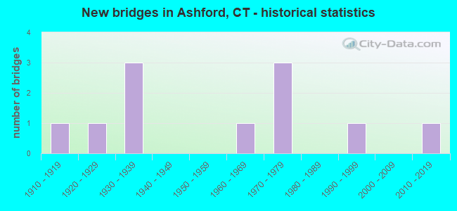
- New bridges - historical statistics
- 11910-1919
- 11920-1929
- 31930-1939
- 11960-1969
- 31970-1979
- 11990-1999
- 12010-2019
FCC Registered Cell Phone Towers:
2 (See the full list of FCC Registered Cell Phone Towers in Ashford)FCC Registered Antenna Towers:
28 (See the full list of FCC Registered Antenna Towers)FCC Registered Broadcast Land Mobile Towers:
2- .1 Mi N Rt 44 & 89 Int (Lat: 41.866778 Lon: -72.157861), Call Sign: KNGE533,
Assigned Frequencies: 33.1000 MHz, Grant Date: 03/29/2023, Expiration Date: 03/30/2033, Registrant: Universal Licensing Service, 4401-A Connecticut Ave Nw #232, Washington, DC 20008, Phone: (877) 677-3639, Fax: (949) 209-3097, Email:
- 353 Pumpkin Hill Rd. (Lat: 41.847861 Lon: -72.121611), Type: Ltower, Structure height: 73.1 m, Overall height: 74.1 m, Call Sign: WNHV903,
Assigned Frequencies: 453.375 MHz, Grant Date: 10/17/2014, Expiration Date: 11/19/2024, Certifier: Robert E Kelley, Registrant: Rmf Consulting, 16 Crescent Court, East Hartford, CT 06118, Phone: (860) 205-0761, Email:
FCC Registered Microwave Towers:
1- CT11353C, Off Frontage Road 0.6km Se Of (Lat: 41.951944 Lon: -72.195278), Type: Ltower, Structure height: 58.2 m, Call Sign: WRVV501,
Assigned Frequencies: 11245.0 MHz, 11245.0 MHz, 11245.0 MHz, 11245.0 MHz, 11245.0 MHz, 11245.0 MHz, 11245.0 MHz, 11245.0 MHz, 11245.0 MHz, 11245.0 MHz... (+12 more), Grant Date: 01/10/2023, Expiration Date: 01/10/2033, Certifier: Jenny Knopf, Registrant: T-Mobile Usa, Inc., 12920 Se 38th Street, Bellevue, WA 98006, Phone: (425) 383-8401, Fax: (425) 383-4040, Email:
FCC Registered Paging Towers:
1- Pumpkin Hill Road (Lat: 41.847611 Lon: -72.121472), Type: Tower, Structure height: 93 m, Call Sign: KNKM752,
Assigned Frequencies: 931.187 MHz, Grant Date: 04/19/1999, Expiration Date: 04/01/2009, Cancellation Date: 05/23/2009, Certifier: Shawn E Endsley, Registrant: Usa Mobility Wireless, Inc., 300 Technology Drive #400, Plano, TX 75074, Phone: (972) 801-1626, Fax: (972) 801-1699, Email:
FCC Registered Amateur Radio Licenses:
47 (See the full list of FCC Registered Amateur Radio Licenses in Ashford)FAA Registered Aircraft:
5- Aircraft: PIPER PA-23-250 (Category: Land, Engines: 2, Seats: 6, Weight: Up to 12,499 Pounds, Speed: 150 mph), Engine: Reciprocating
N-Number: 585B, N585B, N-585B, Serial Number: 27-4819, Certificate Issue Date: 06/19/2009
Registrant (Individual): Lyle E Lilie, 130 Mansfield Rd, Ashford, CT 06278 - Aircraft: CESSNA 172N (Category: Land, Seats: 4, Weight: Up to 12,499 Pounds, Speed: 105 mph), Engine: LYCOMING 0-320 SERIES (180 HP) (Reciprocating)
N-Number: 738GV, N738GV, N-738GV, Serial Number: 17269974, Year manufactured: 1977, Airworthiness Date: 01/03/1978, Certificate Issue Date: 01/08/2019
Registrant (Individual): Raymond Jr Molnar, 213 Kennerson Reservoir Rd, Ashford, CT 06278 - Aircraft: CHAMPION 7KCAB (Category: Land, Seats: 2, Weight: Up to 12,499 Pounds, Speed: 90 mph), Engine: LYCOMING IO-320 SERIES (150 HP) (Reciprocating)
N-Number: 9011L, N9011L, N-9011L, Serial Number: 241-70, Year manufactured: 1970, Airworthiness Date: 02/19/1970, Certificate Issue Date: 11/02/1981
Registrant (Individual): Daniel J Brndiar, 61 Lead Mine Rd, Ashford, CT 06278
Deregistered: Cancel Date: 03/05/2019 - Aircraft: PIPER J3C-65 (Category: Land, Seats: 2, Weight: Up to 12,499 Pounds, Speed: 67 mph), Engine: CONT MOTOR A&C65 SERIES (65 HP) (Reciprocating)
N-Number: 42929, N42929, N-42929, Serial Number: 15288, Year manufactured: 1945, Airworthiness Date: 10/31/1956, Certificate Issue Date: 07/19/1976
Registrant (Individual): Charles J Woytik, 343 Waterfall Rd, Ashford, CT 06278
Deregistered: Cancel Date: 02/07/2018 - Aircraft: PIPER PA-22-150 (Category: Land, Seats: 4, Weight: Up to 12,499 Pounds, Speed: 94 mph), Engine: LYCOMING 0-320 SERIES (180 HP) (Reciprocating)
N-Number: 2859P, N2859P, N-2859P, Serial Number: 22-3161, Year manufactured: 1955, Airworthiness Date: 07/01/1955, Certificate Issue Date: 05/24/1999
Registrant (Individual): Roger T Phillips, 196 Pumpkin Hill Rd, Ashford, CT 06278
Deregistered: Cancel Date: 04/07/2017
2002 - 2018 National Fire Incident Reporting System (NFIRS) incidents
- Fire incident types reported to NFIRS in Ashford, CT
- 24657.1%Structure Fires
- 10925.3%Outside Fires
- 5212.1%Mobile Property/Vehicle Fires
- 245.6%Other
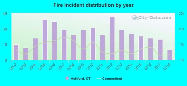 According to the data from the years 2002 - 2018 the average number of fires per year is 25. The highest number of fire incidents - 42 took place in 2012, and the least - 10 in 2018. The data has a decreasing trend.
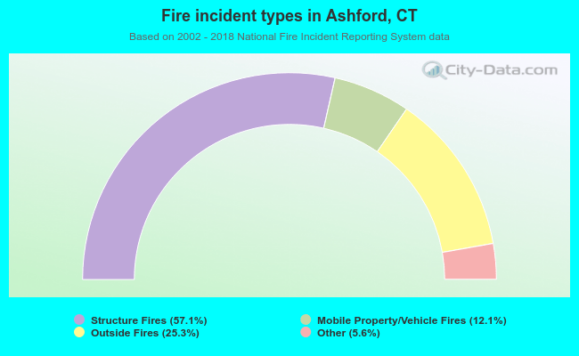 When looking into fire subcategories, the most reports belonged to: Structure Fires (57.1%), and Outside Fires (25.3%).
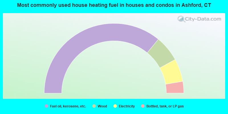
- 71.9%Fuel oil, kerosene, etc.
- 12.1%Wood
- 10.6%Electricity
- 5.4%Bottled, tank, or LP gas
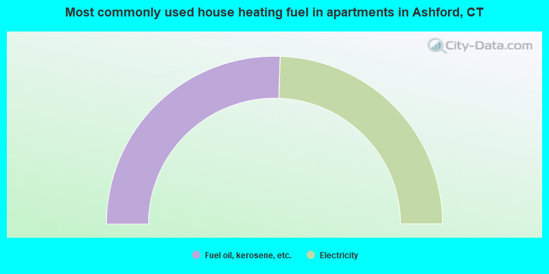
- 51.1%Fuel oil, kerosene, etc.
- 48.9%Electricity
Ashford compared to Connecticut state average:
- Unemployed percentage significantly below state average.
- Black race population percentage significantly below state average.
- Hispanic race population percentage significantly below state average.
- Foreign-born population percentage significantly below state average.
- Length of stay since moving in significantly above state average.
- Number of rooms per house significantly below state average.
- House age significantly below state average.

|
|
Total of 48 patent applications in 2008-2024.