Ashland Rural, Kentucky
Submit your own pictures of this place and show them to the world
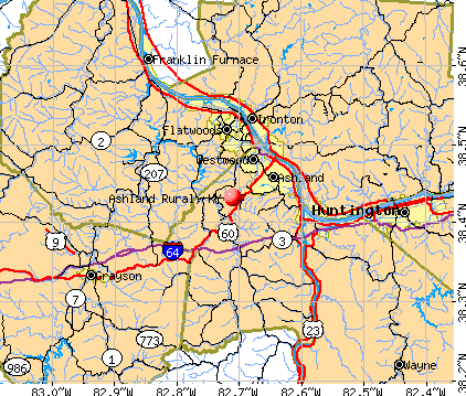
- OSM Map
- General Map
- Google Map
- MSN Map
| Males: 4,506 | |
| Females: 3,436 |
| Median resident age: | 38.2 years |
| Kentucky median age: | 35.9 years |
Zip code: 41102
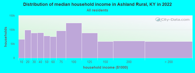
| Ashland Rural: | $64,114 |
| KY: | $59,341 |
Estimated per capita income in 2022: $31,364 (it was $18,178 in 2000)
Ashland Rural CCD income, earnings, and wages data
Estimated median house or condo value in 2022: $157,678 (it was $72,300 in 2000)
| Ashland Rural: | $157,678 |
| KY: | $196,300 |
Detailed information about poverty and poor residents in Ashland Rural, KY
Compare current foreclosures near Ashland Rural, KY:
| Photo | Address | Area | Beds / Baths | Price | Details |
|---|---|---|---|---|---|

|
#1
Route 75
Kenova, WV 25530
|
1,580 sq. feet
|
2 baths 3 beds |
$174,995
|
show details |

|
#2
Twp. Rd 1366
South Point, OH 45680
|
1,144 sq. feet
|
1 baths 2 beds |
$124,900
|
show details |

|
#3
Jackson Ave
Huntington, WV 25704
|
1,450 sq. feet
|
2 baths 2 beds |
$145,000
|
show details |

|
#4
Walnut St
Kenova, WV 25530
|
2,063 sq. feet
|
2 baths 4 beds |
$225,000
|
show details |

|
#5
Township Rd 1007
Chesapeake, OH 45619
|
1,560 sq. feet
|
2 baths 3 beds |
$59,300
|
show details |

|
#6
Valley St
Catlettsburg, KY 41129
|
1,324 sq. feet
|
1 baths 3 beds |
$115,000
|
show details |

|
#7
Charleston Ave
Huntington, WV 25701
|
1,200 sq. feet
|
2 baths 4 beds |
$27,900
|
show details |

|
#8
Beech St
Huntington, WV 25701
|
1,524 sq. feet
|
1 baths 3 beds |
$9,900
|
show details |

|
#9
Ridge St
Russell, KY 41169
|
- sq. feet
|
1 baths 3 beds |
$44,900
|
show details |

|
#10
S 5th St
Ironton, OH 45638
|
2,214 sq. feet
|
2 baths 3 beds |
$20,900
|
show details |
| Photo | Address | Area | Beds / Baths | Price | Details |
|---|---|---|---|---|---|

|
#11
Cumberland Ave
Flatwoods, KY 41139
|
1,450 sq. feet
|
1 baths 3 beds |
show details | |

|
#12
Donald Ave
Huntington, WV 25701
|
1,621 sq. feet
|
1 baths 3 beds |
show details | |

|
#13
County Road 1
South Point, OH 45680
|
1,152 sq. feet
|
1 baths 3 beds |
show details | |

|
#14
Terrace Blvd
Ashland, KY 41102
|
960 sq. feet
|
1 baths 2 beds |
show details | |

|
#15
10th Ave
Huntington, WV 25701
|
2,128 sq. feet
|
2 baths 3 beds |
show details | |

|
#16
S 10th St
Ironton, OH 45638
|
1,662 sq. feet
|
2 baths 4 beds |
show details | |

|
#17
High St W
Ashland, KY 41101
|
754 sq. feet
|
1 baths 2 beds |
show details | |

|
#18
Countryside Dr
Ashland, KY 41102
|
1,040 sq. feet
|
1 baths 3 beds |
show details | |

|
#19
Central Ave
Ashland, KY 41101
|
2 sq. feet
|
1 baths 3 beds |
show details | |

|
#20
Richardson Rd
Ashland, KY 41101
|
2,560 sq. feet
|
2 baths 4 beds |
show details |
| Photo | Address | Area | Beds / Baths | Price | Details |
|---|---|---|---|---|---|

|
#21
State Route 141
Kitts Hill, OH 45645
|
1,396 sq. feet
|
1 baths 2 beds |
show details | |

|
#22
Township Road 301a
Ironton, OH 45638
|
1,363 sq. feet
|
1 baths 3 beds |
show details | |

|
#23
Township Road 1096
Chesapeake, OH 45619
|
1,300 sq. feet
|
2 baths 3 beds |
show details | |

|
#24
W Happy Rdg
Ashland, KY 41102
|
800 sq. feet
|
1 baths 3 beds |
show details | |

|
#25
State Route 5
Ashland, KY 41102
|
1,791 sq. feet
|
2 baths 2 beds |
show details | |

|
#26
Washington St
Ironton, OH 45638
|
1,988 sq. feet
|
2 baths 2 beds |
show details | |

|
#27
Jefferson Ave
Huntington, WV 25704
|
800 sq. feet
|
2 baths 4 beds |
show details | |

|
#28
High St
Ironton, OH 45638
|
1,052 sq. feet
|
1 baths 2 beds |
show details | |

|
#29
Radio Park Rd
Catlettsburg, KY 41129
|
2,344 sq. feet
|
1 baths 4 beds |
show details | |

|
#30
Raleigh Dr
Catlettsburg, KY 41129
|
1,890 sq. feet
|
2 baths 3 beds |
show details |
| Photo | Address | Area | Beds / Baths | Price | Details |
|---|---|---|---|---|---|

|
#31
County Road 105
Kitts Hill, OH 45645
|
2,115 sq. feet
|
1 baths 3 beds |
show details | |

|
#32
Paddle Creek Rd
Catlettsburg, KY 41129
|
880 sq. feet
|
1 baths 3 beds |
show details | |

|
#33
S 5th St
Ironton, OH 45638
|
1,534 sq. feet
|
1 baths 4 beds |
show details | |

|
#34
S 9th St
Ironton, OH 45638
|
1,450 sq. feet
|
1 baths 2 beds |
show details | |

|
#35
Township Road 1097
Chesapeake, OH 45619
|
1,080 sq. feet
|
1 baths 3 beds |
show details | |

|
#36
Trace Rd
Rush, KY 41168
|
1,635 sq. feet
|
2 baths 3 beds |
show details | |

|
#37
Private Drive 702
South Point, OH 45680
|
1,216 sq. feet
|
1 baths 3 beds |
show details | |

|
#38
Oakwood Dr
Ironton, OH 45638
|
1,120 sq. feet
|
2 baths 3 beds |
show details | |

|
#39
Thomas Holw
Rush, KY 41168
|
864 sq. feet
|
1 baths 3 beds |
show details | |

|
#40
Spring Valley Dr
Huntington, WV 25704
|
1,564 sq. feet
|
1 baths 3 beds |
show details |
| Photo | Address | Area | Beds / Baths | Price | Details |
|---|---|---|---|---|---|

|
#41
Sycamore St
Greenup, KY 41144
|
- sq. feet
|
2 baths 4 beds |
show details | |

|
#42
Township Road 1427 W
South Point, OH 45680
|
1,508 sq. feet
|
1 baths 3 beds |
show details | |

|
#43
State Route 93
Ironton, OH 45638
|
1,264 sq. feet
|
1 baths 3 beds |
show details | |

|
#44
Township Road 333
South Point, OH 45680
|
1,232 sq. feet
|
1 baths 1 beds |
show details | |

|
#45
Geswein St
Ironton, OH 45638
|
1,392 sq. feet
|
1 baths 2 beds |
show details | |

|
#46
N 3rd St
Ironton, OH 45638
|
960 sq. feet
|
1 baths 2 beds |
show details | |

|
#47
Westwood Ln
Huntington, WV 25704
|
2,142 sq. feet
|
1 baths 3 beds |
show details | |

|
#48
N 4th St
Ironton, OH 45638
|
768 sq. feet
|
1 baths 3 beds |
show details | |

|
#49
County Road 1
South Point, OH 45680
|
2,219 sq. feet
|
2 baths 3 beds |
show details | |

|
Check over 1 million property listings on Foreclosure.com!
|
browse all offers | |||

- 7,06186.9%White alone
- 5897.3%Black alone
- 3584.4%Hispanic
- 610.8%Two or more races
- 300.4%Asian alone
- 230.3%American Indian alone
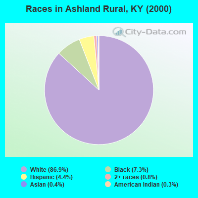
Races in Ashland Rural detailed stats: ancestries, foreign born residents, place of birth
 Recent articles from our blog. Our writers, many of them Ph.D. graduates or candidates, create easy-to-read articles on a wide variety of topics.
Current Local Time: EST time zone
Land area: 30.1 square miles.
Population density: 264 people per square mile (very low).
| Ashland Rural CCD: | 0.7% ($509) |
| Kentucky: | 0.8% ($610) |
Nearest city with pop. 50,000+: Huntington, WV  (15.0 miles , pop. 51,475).
Nearest city with pop. 200,000+: Fayette, KY (100.9 miles , pop. 260,512).
Nearest city with pop. 1,000,000+: Chicago, IL (352.9 miles , pop. 2,896,016).
Nearest cities:
), ), ), ), ), Latitude: 38.43 N, Longitude: 82.71 W
Area code commonly used in this area: 606

| Here: | 5.1% |
| Kentucky: | 3.8% |
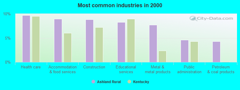
- Health care (9.7%)
- Accommodation & food services (8.9%)
- Construction (8.8%)
- Educational services (8.3%)
- Metal & metal products (7.7%)
- Public administration (4.6%)
- Petroleum & coal products (4.3%)
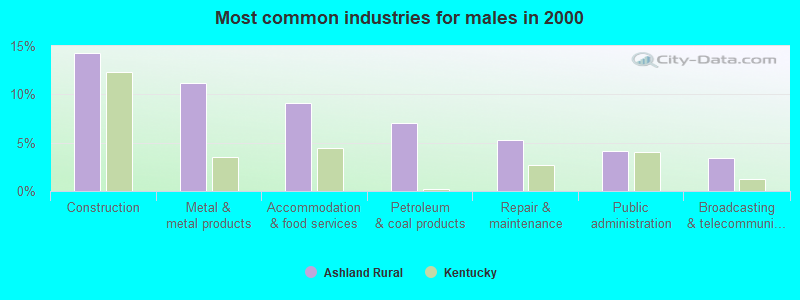
- Construction (14.3%)
- Metal & metal products (11.1%)
- Accommodation & food services (9.1%)
- Petroleum & coal products (7.0%)
- Repair & maintenance (5.3%)
- Public administration (4.2%)
- Broadcasting & telecommunications (3.4%)

- Health care (18.9%)
- Educational services (14.6%)
- Accommodation & food services (8.8%)
- Department & other general merchandise stores (6.9%)
- Finance & insurance (6.2%)
- Professional, scientific, technical services (5.2%)
- Public administration (5.1%)
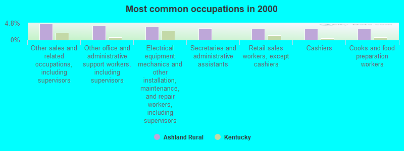
- Other sales and related occupations, including supervisors (4.7%)
- Other office and administrative support workers, including supervisors (4.1%)
- Electrical equipment mechanics and other installation, maintenance, and repair workers, including supervisors (3.8%)
- Secretaries and administrative assistants (3.3%)
- Retail sales workers, except cashiers (3.2%)
- Cashiers (3.2%)
- Cooks and food preparation workers (3.2%)
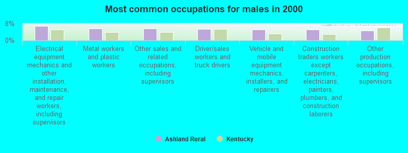
- Electrical equipment mechanics and other installation, maintenance, and repair workers, including supervisors (6.8%)
- Metal workers and plastic workers (5.6%)
- Other sales and related occupations, including supervisors (5.6%)
- Driver/sales workers and truck drivers (5.2%)
- Vehicle and mobile equipment mechanics, installers, and repairers (5.1%)
- Construction traders workers except carpenters, electricians, painters, plumbers, and construction laborers (5.1%)
- Other production occupations, including supervisors (4.7%)

- Other office and administrative support workers, including supervisors (7.9%)
- Secretaries and administrative assistants (7.5%)
- Cashiers (6.5%)
- Preschool, kindergarten, elementary, and middle school teachers (4.4%)
- Other teachers, instructors, education, training, and library occupations (4.3%)
- Retail sales workers, except cashiers (3.9%)
- Information and record clerks, except customer service representatives (3.5%)
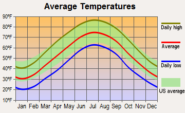
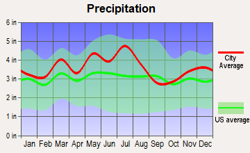
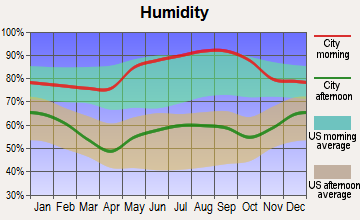
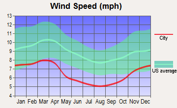
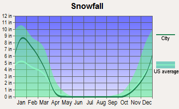
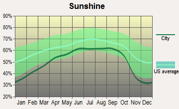
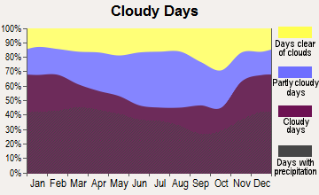
Average climate in Ashland Rural, Kentucky
Based on data reported by over 4,000 weather stations
(lower is better)
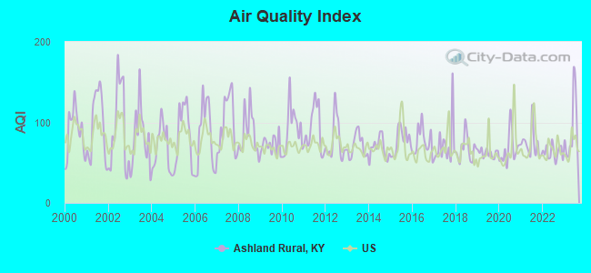
Air Quality Index (AQI) level in 2023 was 90.8. This is worse than average.
| City: | 90.8 |
| U.S.: | 72.6 |
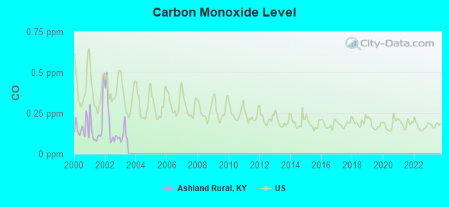
Carbon Monoxide (CO) [ppm] level in 2002 was 0.180. This is better than average. Closest monitor was 4.1 miles away from the city center.
| City: | 0.180 |
| U.S.: | 0.251 |
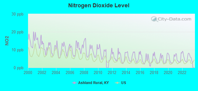
Nitrogen Dioxide (NO2) [ppb] level in 2022 was 5.87. This is about average. Closest monitor was 3.5 miles away from the city center.
| City: | 5.87 |
| U.S.: | 5.11 |
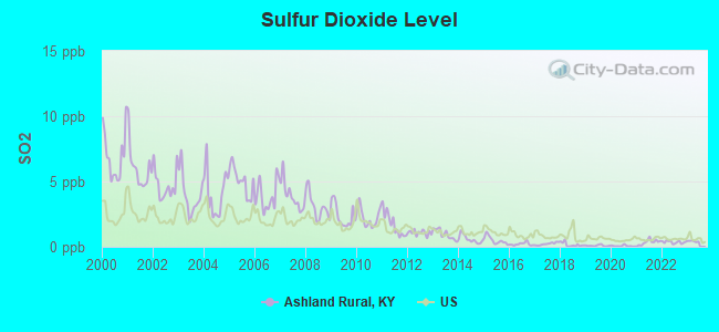
Sulfur Dioxide (SO2) [ppb] level in 2023 was 0.319. This is significantly better than average. Closest monitor was 3.5 miles away from the city center.
| City: | 0.319 |
| U.S.: | 1.515 |
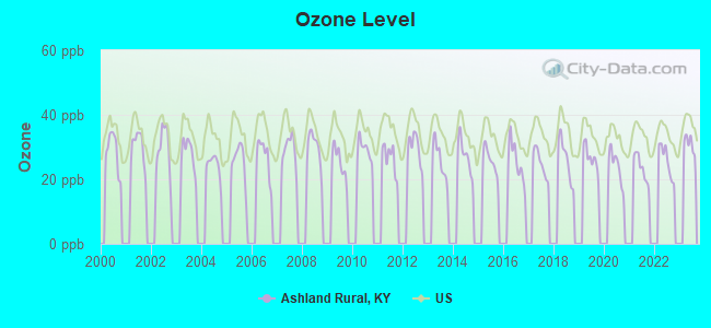
Ozone [ppb] level in 2022 was 25.7. This is better than average. Closest monitor was 4.6 miles away from the city center.
| City: | 25.7 |
| U.S.: | 33.3 |
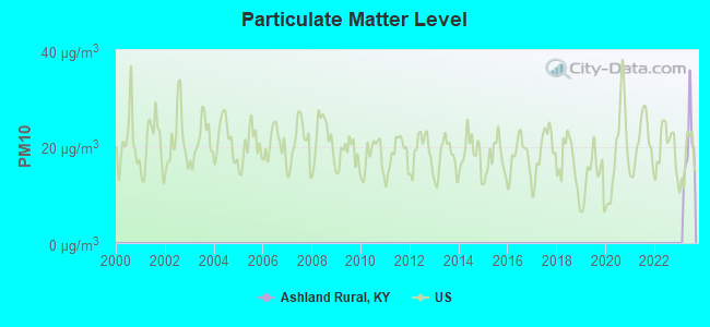
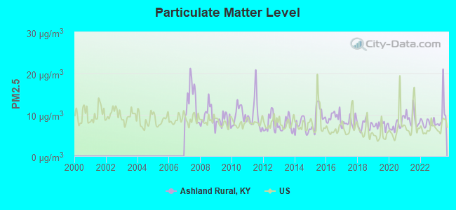
Particulate Matter (PM2.5) [µg/m3] level in 2023 was 10.0. This is worse than average. Closest monitor was 4.2 miles away from the city center.
| City: | 10.0 |
| U.S.: | 8.1 |
Tornado activity:
Ashland Rural-area historical tornado activity is significantly below Kentucky state average. It is 50% smaller than the overall U.S. average.
On 4/23/1968, a category F5 (max. wind speeds 261-318 mph) tornado 19.2 miles away from the Ashland Rural place center killed 7 people and injured 93 people and caused between $500,000 and $5,000,000 in damages.
On 4/8/1965, a category F3 (max. wind speeds 158-206 mph) tornado 5.4 miles away from the place center injured 3 people and caused between $50,000 and $500,000 in damages.
Earthquake activity:
Ashland Rural-area historical earthquake activity is significantly above Kentucky state average. It is 15% greater than the overall U.S. average.On 7/27/1980 at 18:52:21, a magnitude 5.2 (5.1 MB, 4.7 MS, 5.0 UK, 5.2 UK, Class: Moderate, Intensity: VI - VII) earthquake occurred 68.7 miles away from the city center
On 8/23/2011 at 17:51:04, a magnitude 5.8 (5.8 MW, Depth: 3.7 mi) earthquake occurred 262.1 miles away from Ashland Rural center
On 8/9/2020 at 12:07:37, a magnitude 5.1 (5.1 MW, Depth: 4.7 mi) earthquake occurred 161.8 miles away from the city center
On 9/7/1988 at 02:28:09, a magnitude 4.6 (4.5 MB, 4.6 LG, Class: Light, Intensity: IV - V) earthquake occurred 66.5 miles away from the city center
On 4/18/2008 at 09:36:59, a magnitude 5.4 (5.1 MB, 4.8 MS, 5.4 MW, 5.2 MW) earthquake occurred 280.4 miles away from Ashland Rural center
On 9/25/1998 at 19:52:52, a magnitude 5.2 (4.8 MB, 4.3 MS, 5.2 LG, 4.5 MW, Depth: 3.1 mi) earthquake occurred 244.6 miles away from the city center
Magnitude types: regional Lg-wave magnitude (LG), body-wave magnitude (MB), surface-wave magnitude (MS), moment magnitude (MW)
Natural disasters:
The number of natural disasters in Boyd County (24) is greater than the US average (15).Major Disasters (Presidential) Declared: 18
Emergencies Declared: 3
Causes of natural disasters: Floods: 17, Storms: 15, Mudslides: 7, Tornadoes: 7, Winter Storms: 6, Landslides: 5, Snowstorms: 2, Blizzard: 1, Hurricane: 1, Snowfall: 1, Wind: 1, Other: 1 (Note: some incidents may be assigned to more than one category).
Hospitals and medical centers near Ashland Rural:
- BOYD NURSING AND REHABILITATION CENTER (Nursing Home, about 4 miles away; ASHLAND, KY)
- KINGSBROOK LIFECARE CENTER (Nursing Home, about 5 miles away; ASHLAND, KY)
- WOODLAND OAKS (Nursing Home, about 5 miles away; ASHLAND, KY)
- FMC - CENTRAL ASHLAND (Dialysis Facility, about 5 miles away; ASHLAND, KY)
- AMEDISYS HOME HEALTH (Home Health Center, about 5 miles away; ASHLAND, KY)
- KING'S DAUGHTERS' MEDICAL CENTER Acute Care Hospitals (about 5 miles away; ASHLAND, KY)
- COMMUNITY HOSPICE (Hospital, about 5 miles away; ASHLAND, KY)
Amtrak stations near Ashland Rural:
- 6 miles: ASHLAND (99 15TH ST.) . Services: fully wheelchair accessible, enclosed waiting area, public restrooms, public payphones, vending machines, free short-term parking, free long-term parking, call for taxi service, public transit connection.
- 15 miles: HUNTINGTON (8TH AVE. & 10TH ST.) . Services: ticket office, fully wheelchair accessible, enclosed waiting area, public restrooms, public payphones, free short-term parking, free long-term parking, call for taxi service.
Colleges/universities with over 2000 students nearest to Ashland Rural:
- Ashland Community and Technical College (about 5 miles; Ashland, KY; Full-time enrollment: 2,482)
- Marshall University (about 16 miles; Huntington, WV; FT enrollment: 11,450)
- Shawnee State University (about 26 miles; Portsmouth, OH; FT enrollment: 4,160)
- Morehead State University (about 43 miles; Morehead, KY; FT enrollment: 7,523)
- West Virginia State University (about 52 miles; Institute, WV; FT enrollment: 2,133)
- Big Sandy Community and Technical College (about 52 miles; Prestonsburg, KY; FT enrollment: 2,660)
- Maysville Community and Technical College (about 61 miles; Maysville, KY; FT enrollment: 2,969)
Points of interest:
Notable locations in Ashland Rural: Camp George M Verity (A), Summit - Ironville Fire Protection (B). Display/hide their locations on the map
Churches in Ashland Rural include: Wayside Church (A), Liberty Church (B), Williams Creek Church (C), Straight Creek Church (D), Trinity Church (E). Display/hide their locations on the map
Cemeteries: Cumpston Cemetery (1), Newman Cemetery (2), Click Cemetery (3), McCalvin Cemetery (4), Kirby Flats Cemetery (5). Display/hide their locations on the map
Reservoirs: Arrowhead Lake (A), Mary Carol Lake (B), Grandview Lake (C). Display/hide their locations on the map
Streams, rivers, and creeks: Big Garner Creek (A), Brush Creek (B), Cobb Fork (C), Williams Creek (D), Straight Creek (E), Shope Creek (F), Buena Vista Branch (G), Marsh Run (H), Little Garner Creek (I). Display/hide their locations on the map
| This place: | 2.5 people |
| Kentucky: | 2.5 people |
| This place: | 65.3% |
| Whole state: | 69.8% |
| This place: | 3.7% |
| Whole state: | 4.5% |
Likely homosexual households (counted as self-reported same-sex unmarried-partner households)
- Lesbian couples: 0.2% of all households
- Gay men: 0.1% of all households
| This place: | 12.6% |
| Whole state: | 15.8% |
| This place: | 4.2% |
| Whole state: | 6.6% |
People in group quarters in Ashland Rural in 2000:
- 1,358 people in federal prisons and detention centers
- 57 people in nursing homes
- 11 people in college dormitories (includes college quarters off campus)
- 7 people in other noninstitutional group quarters
For population 15 years and over in Ashland Rural:
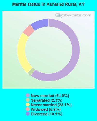
- Never married: 23.1%
- Now married: 61.0%
- Separated: 2.3%
- Widowed: 5.8%
- Divorced: 10.1%
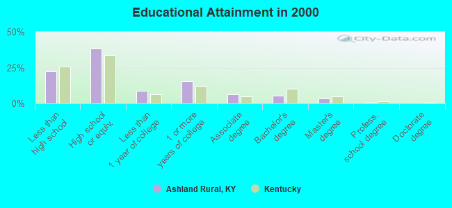
For population 25 years and over in Ashland Rural:
- High school or higher: 77.9%
- Bachelor's degree or higher: 9.1%
- Graduate or professional degree: 3.6%
- Unemployed: 6.8%
- Mean travel time to work (commute): 20.7 minutes

| Here: | 11.3 |
| Kentucky average: | 13.8 |
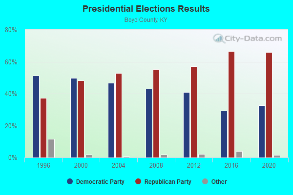
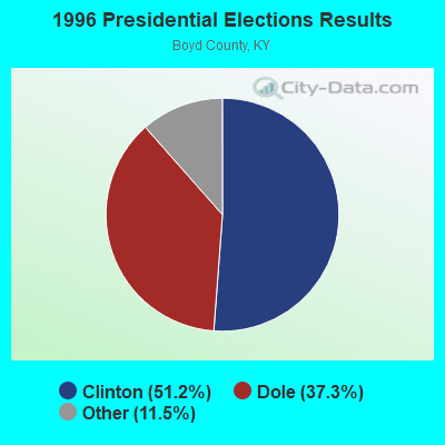
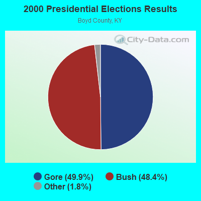


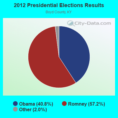
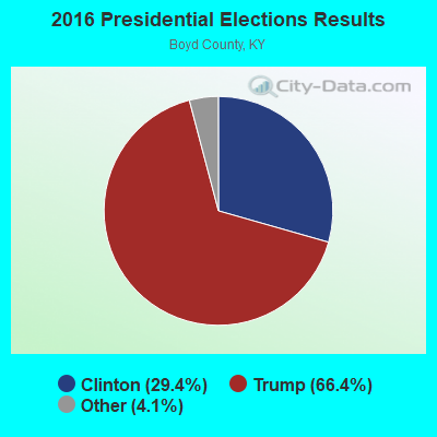

Graphs represent county-level data. Detailed 2008 Election Results
Religion statistics for Ashland Rural, KY (based on Boyd County data)
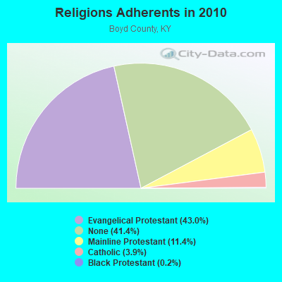
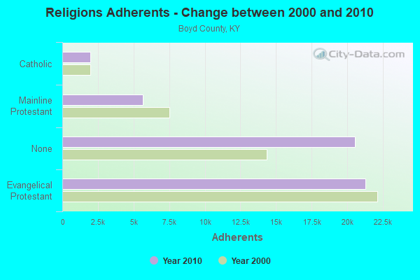
| Religion | Adherents | Congregations |
|---|---|---|
| Evangelical Protestant | 21,279 | 85 |
| Mainline Protestant | 5,660 | 20 |
| Catholic | 1,950 | 1 |
| Black Protestant | 120 | 2 |
| Other | 3 | 1 |
| None | 20,530 | - |
Food Environment Statistics:
| Boyd County: | 2.27 / 10,000 pop. |
| Kentucky: | 2.19 / 10,000 pop. |
| This county: | 0.21 / 10,000 pop. |
| State: | 0.25 / 10,000 pop. |
| Boyd County: | 0.21 / 10,000 pop. |
| Kentucky: | 0.74 / 10,000 pop. |
| Boyd County: | 6.19 / 10,000 pop. |
| State: | 4.36 / 10,000 pop. |
| Here: | 6.81 / 10,000 pop. |
| State: | 5.74 / 10,000 pop. |
| This county: | 12.7% |
| Kentucky: | 11.0% |
| Boyd County: | 32.2% |
| Kentucky: | 30.0% |
| This county: | 15.4% |
| State: | 15.9% |
Strongest AM radio stations in Ashland Rural:
- WOKT (1040 AM; daytime; 2 kW; CANNONSBURG, KY; Owner: BIG RIVER RADIO, INC.-KY)
- WTCR (1420 AM; 5 kW; KENOVA, WV; Owner: CAPSTAR TX LIMITED PARTNERSHIP)
- WRVC (930 AM; 5 kW; HUNTINGTON, WV; Owner: FIFTH AVENUE BROADCASTING COMPANY, INC.)
- WVHU (800 AM; 5 kW; HUNTINGTON, WV; Owner: CAPSTAR TX LIMITED PARTNERSHIP)
- WCMI (1340 AM; 1 kW; ASHLAND, KY; Owner: FIFTH AVENUE BROADCASTING CO., INC)
- WHRD (1470 AM; 5 kW; HUNTINGTON, WV; Owner: CONCORD MEDIA GROUP, INC.)
- WLGC (1520 AM; daytime; 5 kW; GREENUP, KY; Owner: GREENUP COUNTY BROADCASTING, INC.)
- WGOH (1370 AM; 5 kW; GRAYSON, KY; Owner: CARTER COUNTY BROADCASTING CO., INC.)
- WIRO (1230 AM; 1 kW; IRONTON, OH; Owner: CAPSTAR TX LIMITED PARTNERSHIP)
- WTVN (610 AM; 50 kW; COLUMBUS, OH; Owner: CITICASTERS LICENSES, L.P.)
- WLW (700 AM; 50 kW; CINCINNATI, OH; Owner: JACOR BROADCASTING CORPORATION)
- WBGS (1030 AM; daytime; 10 kW; POINT PLEASANT, WV; Owner: BIG RIVER RADIO, INC.)
- WNXT (1260 AM; 5 kW; PORTSMOUTH, OH; Owner: HOMETOWN B/C OF PORTSMOUTH, INC.)
Strongest FM radio stations in Ashland Rural:
- WDGG (93.7 FM; ASHLAND, KY; Owner: FIFTH AVENUE B/CASTING COMPANY, INC.)
- WBKS (107.1 FM; IRONTON, OH; Owner: CAPSTAR TX LIMITED PARTNERSHIP)
- WBVB (97.1 FM; COAL GROVE, OH; Owner: CAPSTAR TX LIMITED PARTNERSHIP)
- WRVC-FM (92.7 FM; CATLETTSBURG, KY; Owner: FIFTH AVENUE BROADCASTING CO., INC)
- WOUL-FM (89.1 FM; IRONTON, OH; Owner: OHIO UNIVERSITY)
- WPAY-FM (104.1 FM; PORTSMOUTH, OH; Owner: RADIO STATIONS WPAY/WPFB, INC.)
- WKEE-FM (100.5 FM; HUNTINGTON, WV; Owner: CAPSTAR TX LIMITED PARTNERSHIP)
- WLGC-FM (105.7 FM; GREENUP, KY; Owner: GREENUP COUNTY BROADCASTING, INC.)
- WVWV (89.9 FM; HUNTINGTON, WV; Owner: WEST VIRGINIA EDUCATIONAL BROADCASTING AUTHORITY)
- WAMX (106.3 FM; MILTON, WV; Owner: CAPSTAR TX LIMITED PARTNERSHIP)
- WOSP (91.5 FM; PORTSMOUTH, OH; Owner: THE OHIO STATE UNIVERSITY)
- WRYV-FM1 (101.5 FM; HUNTINGTON, WV; Owner: LEGEND COMMUNICATIONS OF OHIO, LLC)
- W216AT (91.1 FM; ASHLAND, KY; Owner: AMERICAN FAMILY ASSOCIATION)
- WTCR-FM (103.3 FM; HUNTINGTON, WV; Owner: CAPSTAR TX LIMITED PARTNERSHIP)
- WKLC-FM (105.1 FM; ST. ALBANS, WV; Owner: WKLC, INC.)
- WUGO (102.3 FM; GRAYSON, KY; Owner: CARTER COUNTY BROADCASTING CO., INC.)
- WOHP (88.3 FM; PORTSMOUTH, OH; Owner: THE CEDARVILLE UNIVERSITY)
- WZAQ (92.3 FM; LOUISA, KY; Owner: LOUISA COMMUNICATIONS, INC.)
- WOKE (98.3 FM; GARRISON, KY; Owner: BIG RIVER RADIO, INC.)
- WMEJ (91.9 FM; PROCTORVILLE, OH; Owner: MARANATHA BROADCASTING INC.)
TV broadcast stations around Ashland Rural:
- WKAS (Channel 25; ASHLAND, KY; Owner: KENTUCKY AUTHORITY FOR EDUCATIONAL TV)
- W49BN (Channel 49; HUNTINGTON, WV; Owner: PAXSON COMMUNCATIONS LPTV, INC.)
- WPBY-TV (Channel 33; HUNTINGTON, WV; Owner: WEST VIRGINIA EDUCATIONAL BROADCASTING AUTHORITY)
- WSAZ-TV (Channel 3; HUNTINGTON, WV; Owner: EMMIS TELEVISION LICENSE CORPORATION)
- WVAH-TV (Channel 11; CHARLESTON, WV; Owner: WVAH LICENSEE, LLC)
- WOWK-TV (Channel 13; HUNTINGTON, WV; Owner: WEST VIRGINIA MEDIA HOLDINGS, LLC)
- W14CU (Channel 14; HUNTINGTON, WV; Owner: VENTANA TELEVISION, INC.)
- W05CB (Channel 5; BURLINGTON, OH; Owner: VEARL R. PENNINGTON)
- WPBO (Channel 42; PORTSMOUTH, OH; Owner: THE OHIO STATE UNIVERSITY)
- WCHS-TV (Channel 8; CHARLESTON, WV; Owner: WCHS LICENSEE, LLC)
- WTSF (Channel 61; ASHLAND, KY; Owner: TRI STATE FAMILY BROADCASTING, INC.)
- WHCP (Channel 30; PORTSMOUTH, OH; Owner: TELEVISION PROPERTIES, INC.)
- W36CR (Channel 36; HUNTINGTON, WV; Owner: NATIONAL MINORITY T.V., INC.)
- W55AT (Channel 55; HUNTINGTON, WV; Owner: CHANNEL AMERICA LPTV LIC. SUBSIDIARY)
- W66CZ (Channel 66; PORTSMOUTH, OH; Owner: TRINITY BROADCASTING NETWORK)
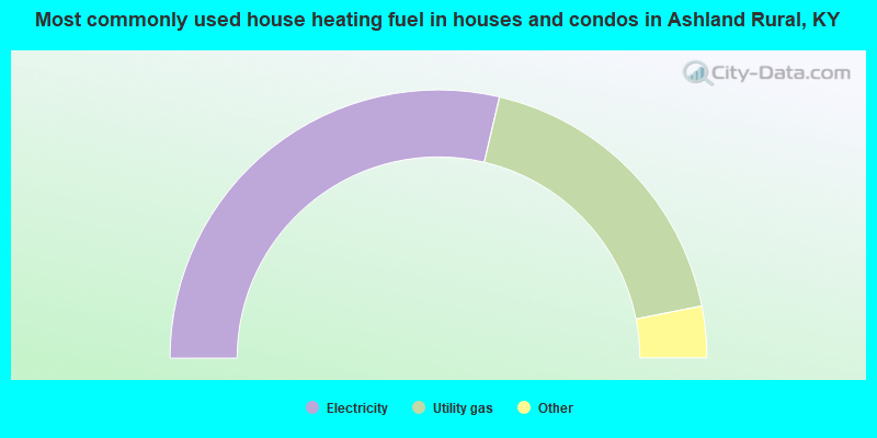
- 57.3%Electricity
- 36.5%Utility gas
- 3.3%Bottled, tank, or LP gas
- 1.4%Coal or coke
- 1.1%Wood
- 0.4%Other fuel
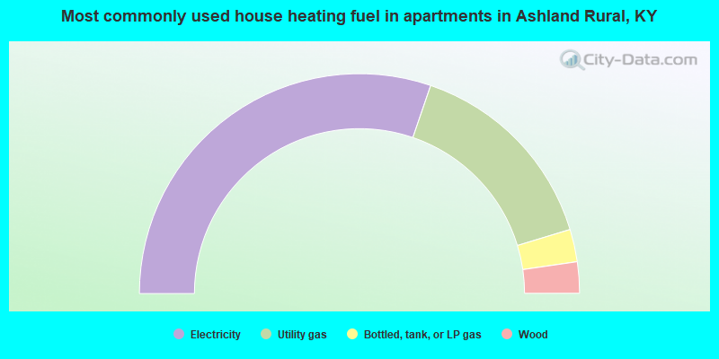
- 60.5%Electricity
- 30.1%Utility gas
- 4.8%Bottled, tank, or LP gas
- 4.6%Wood
Ashland Rural compared to Kentucky state average:
- Unemployed percentage below state average.
- Foreign-born population percentage significantly below state average.
- Renting percentage significantly below state average.
- Length of stay since moving in significantly above state average.
- Number of rooms per house significantly below state average.
- House age significantly below state average.
- Institutionalized population percentage significantly above state average.
- Percentage of population with a bachelor's degree or higher below state average.
Ashland Rural on our top lists:
- #2 on the list of "Top 101 cities with largest percentage of males in industries: petroleum and coal products (population 5,000+)"
- #8 on the list of "Top 101 cities with largest percentage of males in industries: pharmacies and drug stores (population 5,000+)"
- #9 on the list of "Top 101 cities with largest percentage of females in occupations: plant and system operators (population 5,000+)"
- #10 on the list of "Top 101 cities with largest percentage of females in occupations: drafters, engineering, and mapping technicians (population 5,000+)"
- #10 on the list of "Top 101 cities with largest percentage of females in industries: jewelry, luggage, and leather goods stores (population 5,000+)"
- #14 on the list of "Top 101 cities with largest percentage of males in industries: metal and metal products (population 5,000+)"
- #14 on the list of "Top 101 cities with largest percentage of males in industries: recyclable material merchant wholesalers (population 5,000+)"
- #15 on the list of "Top 101 cities with largest percentage of females in industries: petroleum and coal products (population 5,000+)"
- #17 on the list of "Top 101 cities with largest percentage of males in occupations: rail and water transportation workers (population 5,000+)"
- #18 on the list of "Top 101 cities with largest percentage of females in industries: department and other general merchandise stores (population 5,000+)"
- #19 on the list of "Top 101 cities with the largest percentage of people in federal prisons and detention centers (population 1,000+)"
- #25 on the list of "Top 101 cities with largest percentage of females in industries: metal and metal products (population 5,000+)"
- #30 on the list of "Top 101 cities with largest percentage of males in industries: paper and paper products merchant wholesalers (population 5,000+)"
- #44 on the list of "Top 101 cities with largest percentage of males in occupations: drafters, engineering, and mapping technicians (population 5,000+)"
- #44 on the list of "Top 101 cities with largest percentage of males in occupations: judges, magistrates, and other judicial workers (population 5,000+)"
- #48 on the list of "Top 101 cities with largest percentage of females in industries: paper and paper products merchant wholesalers (population 5,000+)"
- #48 on the list of "Top 101 cities with largest percentage of males in industries: rail transportation (population 5,000+)"
- #56 on the list of "Top 101 cities with largest percentage of females in occupations: occupational and physical therapist assistants and aides (population 5,000+)"
- #59 on the list of "Top 101 cities with largest percentage of females in industries: petroleum and petroleum products merchant wholesalers (population 5,000+)"
- #64 on the list of "Top 101 cities with largest percentage of males in industries: alcoholic beverages merchant wholesalers (population 5,000+)"
- #22 on the list of "Top 101 counties with the highest Nitrogen Dioxide air pollution readings in 2012 (ppm)"
- #84 on the list of "Top 101 counties with the highest Sulfur Oxides Annual air pollution readings in 2012 (µg/m3)"