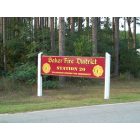
Baker, Florida
Submit your own pictures of this place and show them to the world
- OSM Map
- General Map
- Google Map
- MSN Map
| Males: 3,556 | |
| Females: 3,578 |
| Median resident age: | 37.9 years |
| Florida median age: | 38.7 years |
Zip code: 32531
| Baker: | $64,519 |
| FL: | $69,303 |
Estimated per capita income in 2022: $29,267 (it was $15,340 in 2000)
Baker CCD income, earnings, and wages data
Estimated median house or condo value in 2022: $234,833 (it was $64,800 in 2000)
| Baker: | $234,833 |
| FL: | $354,100 |
Mean prices in 2022: all housing units: $458,366; detached houses: $481,682; townhouses or other attached units: $326,334; in 2-unit structures: $475,728; in 3-to-4-unit structures: $335,472; in 5-or-more-unit structures: $488,682; mobile homes: $102,737; occupied boats, rvs, vans, etc.: $82,243
Detailed information about poverty and poor residents in Baker, FL


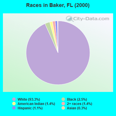
- 6,29093.3%White alone
- 1672.5%Black alone
- 961.4%American Indian alone
- 921.4%Two or more races
- 711.1%Hispanic
- 220.3%Asian alone
- 40.06%Native Hawaiian and Other
Pacific Islander alone
Races in Baker detailed stats: ancestries, foreign born residents, place of birth
According to our research of Florida and other state lists, there were 32 registered sex offenders living in Baker, Florida as of May 01, 2024.
The ratio of all residents to sex offenders in Baker is 223 to 1.
 Recent articles from our blog. Our writers, many of them Ph.D. graduates or candidates, create easy-to-read articles on a wide variety of topics.
Current Local Time: CST time zone
Land area: 253.6 square miles.
Population density: 28 people per square mile (very low).

| Baker CCD: | 0.5% ($309) |
| Florida: | 1.4% ($1,262) |
Nearest city with pop. 50,000+: Gulf Breeze-Harold, FL (27.8 miles  , pop. 54,412).
Nearest city with pop. 200,000+: Montgomery, AL (109.3 miles , pop. 201,568).
Nearest city with pop. 1,000,000+: Houston, TX (523.9 miles , pop. 1,953,631).
Nearest cities:
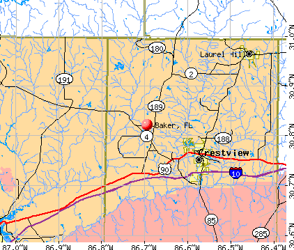
), ), ), ), ), )Latitude: 30.82 N, Longitude: 86.69 W
Area code: 850

| Here: | 2.6% |
| Florida: | 2.9% |
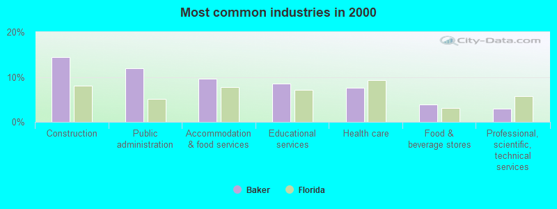
- Construction (14.5%)
- Public administration (12.0%)
- Accommodation & food services (9.6%)
- Educational services (8.6%)
- Health care (7.5%)
- Food & beverage stores (3.8%)
- Professional, scientific, technical services (3.0%)
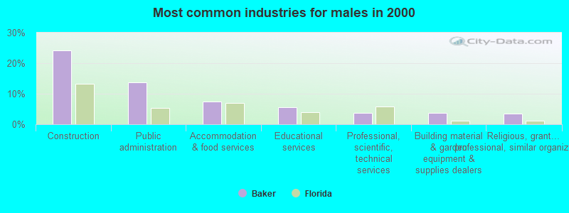
- Construction (24.2%)
- Public administration (13.8%)
- Accommodation & food services (7.4%)
- Educational services (5.6%)
- Professional, scientific, technical services (3.7%)
- Building material & garden equipment & supplies dealers (3.6%)
- Religious, grantmaking, civic, professional, similar organizations (3.5%)
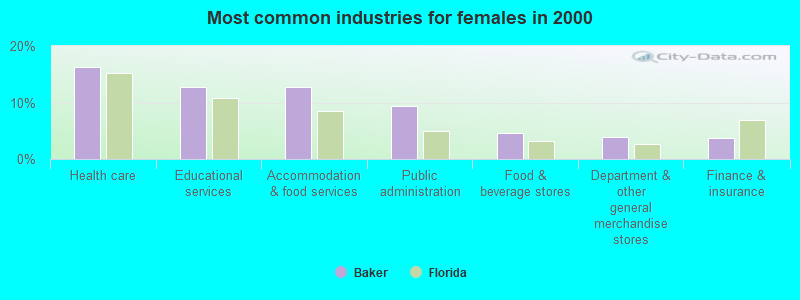
- Health care (16.3%)
- Educational services (12.8%)
- Accommodation & food services (12.7%)
- Public administration (9.4%)
- Food & beverage stores (4.6%)
- Department & other general merchandise stores (3.9%)
- Finance & insurance (3.8%)
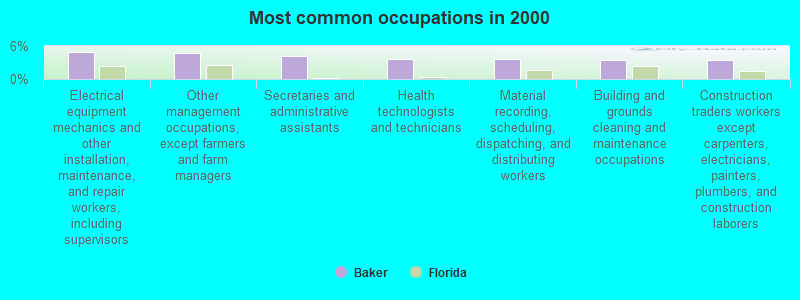
- Electrical equipment mechanics and other installation, maintenance, and repair workers, including supervisors (5.0%)
- Other management occupations, except farmers and farm managers (4.6%)
- Secretaries and administrative assistants (4.1%)
- Health technologists and technicians (3.7%)
- Material recording, scheduling, dispatching, and distributing workers (3.6%)
- Building and grounds cleaning and maintenance occupations (3.4%)
- Construction traders workers except carpenters, electricians, painters, plumbers, and construction laborers (3.4%)
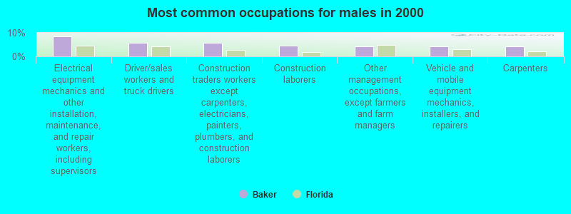
- Electrical equipment mechanics and other installation, maintenance, and repair workers, including supervisors (8.4%)
- Driver/sales workers and truck drivers (5.7%)
- Construction traders workers except carpenters, electricians, painters, plumbers, and construction laborers (5.7%)
- Construction laborers (4.7%)
- Other management occupations, except farmers and farm managers (4.1%)
- Vehicle and mobile equipment mechanics, installers, and repairers (4.1%)
- Carpenters (4.1%)
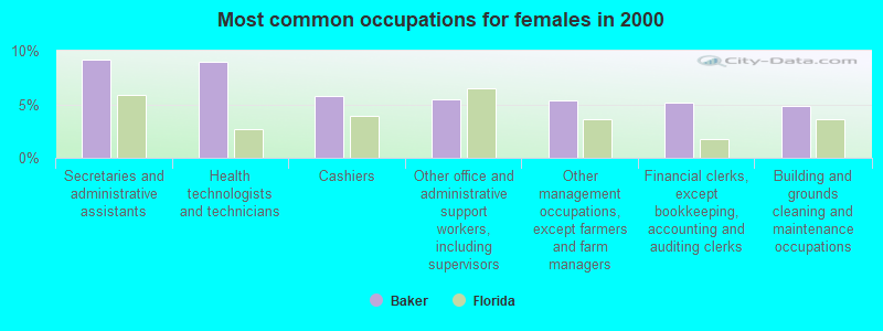
- Secretaries and administrative assistants (9.1%)
- Health technologists and technicians (9.0%)
- Cashiers (5.8%)
- Other office and administrative support workers, including supervisors (5.4%)
- Other management occupations, except farmers and farm managers (5.4%)
- Financial clerks, except bookkeeping, accounting and auditing clerks (5.2%)
- Building and grounds cleaning and maintenance occupations (4.9%)
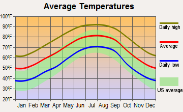
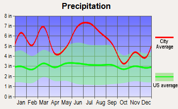
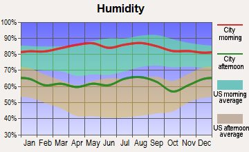
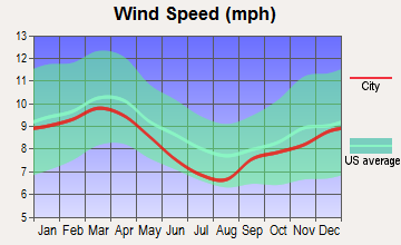
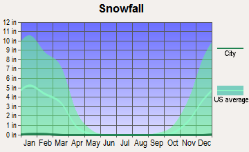
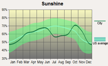
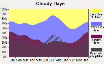
Average climate in Baker, Florida
Based on data reported by over 4,000 weather stations
Tornado activity:
Baker-area historical tornado activity is slightly above Florida state average. It is 34% greater than the overall U.S. average.
On 3/31/1962, a category F3 (max. wind speeds 158-206 mph) tornado 21.0 miles away from the Baker place center killed 17 people and injured 100 people and caused between $500,000 and $5,000,000 in damages.
On 12/25/1964, a category F3 tornado 26.5 miles away from the place center injured 4 people and caused between $500,000 and $5,000,000 in damages.
Earthquake activity:
Baker-area historical earthquake activity is significantly above Florida state average. It is 62% smaller than the overall U.S. average.On 10/24/1997 at 08:35:17, a magnitude 4.9 (4.8 MB, 4.2 MS, 4.9 LG, Depth: 6.2 mi, Class: Light, Intensity: IV - V) earthquake occurred 40.1 miles away from Baker center
On 9/10/2006 at 14:56:08, a magnitude 5.9 (5.9 MB, 5.5 MS, 5.8 MW, Class: Moderate, Intensity: VI - VII) earthquake occurred 316.3 miles away from the city center
On 1/18/1999 at 07:00:53, a magnitude 4.8 (4.8 MB, 4.0 LG, Depth: 0.6 mi) earthquake occurred 181.6 miles away from the city center
On 9/3/2020 at 15:07:53, a magnitude 3.8 (3.8 MW, Depth: 2.5 mi, Class: Light, Intensity: II - III) earthquake occurred 32.5 miles away from the city center
On 11/7/2004 at 11:20:21, a magnitude 4.3 (4.3 MW, Depth: 3.1 mi) earthquake occurred 145.9 miles away from Baker center
On 4/29/2003 at 08:59:39, a magnitude 4.9 (4.4 MB, 4.6 MW, 4.9 LG) earthquake occurred 261.4 miles away from the city center
Magnitude types: regional Lg-wave magnitude (LG), body-wave magnitude (MB), surface-wave magnitude (MS), moment magnitude (MW)
Natural disasters:
The number of natural disasters in Okaloosa County (28) is a lot greater than the US average (15).Major Disasters (Presidential) Declared: 20
Emergencies Declared: 4
Causes of natural disasters: Hurricanes: 15, Floods: 7, Tropical Storms: 5, Storms: 4, Tornadoes: 3, Winds: 3, Heavy Rains: 2, Fire: 1, Other: 1 (Note: some incidents may be assigned to more than one category).
Airports located in Baker:
- Skypark Estates Owners Assoc Airport (18FD) (Runways: 1, Itinerant Ops: 5, Local Ops: 25)
- Dotson Airport (55FD) (Runways: 1)
Colleges/universities with over 2000 students nearest to Baker:
- Northwest Florida State College (about 24 miles; Niceville, FL; Full-time enrollment: 5,052)
- The University of West Florida (about 37 miles; Pensacola, FL; FT enrollment: 10,240)
- Pensacola State College (about 39 miles; Pensacola, FL; FT enrollment: 8,740)
- Enterprise State Community College (about 61 miles; Enterprise, AL; FT enrollment: 2,101)
- James H Faulkner State Community College (about 65 miles; Bay Minette, AL; FT enrollment: 3,703)
- Columbia Southern University (about 67 miles; Orange Beach, AL; FT enrollment: 14,996)
- Gulf Coast State College (about 73 miles; Panama City, FL; FT enrollment: 4,474)
Public high school in Baker:
- BAKER SCHOOL (Students: 316, Location: 1369 14TH ST, Grades: PK-12)
Points of interest:
Notable locations in Baker: Bluff Landing (A), Meritt Landing (B), Okaloosa County Emergency Medical Services Station 5 (C), Baker Fire District (D), Blackman Volunteer Fire Department (E), North Okaloosa Fire Department Station 83 (F), Holt Volunteer Fire District (G). Display/hide their locations on the map
Churches in Baker include: Beaver Creek Church (A), Pyron Spring Chapel (B), Lighthouse Church (C), Rock Hill Church (D), Red Oak Church (E), Olive Branch Church (F), Shady Grove Church (G), New Bethany Church (H), Bullard Church (I). Display/hide their locations on the map
Cemeteries: Beulah Cemetery (1), Stewart Cemetery (2), Griffith Cemetery (3), Holt Cemetery (4), Rock Hill Cemetery (5), Cobb Cemetery (6), Hobbs Cemetery (7). Display/hide their locations on the map
Lakes and reservoirs: Martins Mill Pond (A), Danley Pond (B), Guest Lake (C), E C Younghood Pond (D), O G Steele Pond (E), Carver Pond (F), Dixon Lake (G), A A Hilton Pond (H). Display/hide their locations on the map
Streams, rivers, and creeks: Little Escambia Creek (A), Bone Creek (B), Big Branch (C), Reedy Creek (D), Polley Creek (E), Panther Creek (F), Olive Branch (G), Oak Creek (H), Mare Creek (I). Display/hide their locations on the map
Tourist attraction: Baker Block Museum (1307 Georgia Avenue) (1). Display/hide its approximate location on the map
Drinking water stations with addresses in Baker and their reported violations in the past:
BLACKMAN COMMUNITY (Population served: 1,127, Groundwater):Past monitoring violations:
- Initial Tap Sampling for Pb and Cu - In JAN-01-2013, Contaminant: Lead and Copper Rule
Drinking water stations with addresses in Baker that have no violations reported:
- BAKER WATER SYSTEM, INC. (Population served: 2,975, Primary Water Source Type: Groundwater)
| This place: | 2.5 people |
| Florida: | 2.5 people |
| This place: | 73.8% |
| Whole state: | 65.2% |
| This place: | 6.1% |
| Whole state: | 7.3% |
Likely homosexual households (counted as self-reported same-sex unmarried-partner households)
- Lesbian couples: 0.5% of all households
- Gay men: 0.1% of all households
| This place: | 11.4% |
| Whole state: | 12.5% |
| This place: | 4.3% |
| Whole state: | 5.7% |
4 people in homes for the mentally retarded in 2000
For population 15 years and over in Baker:
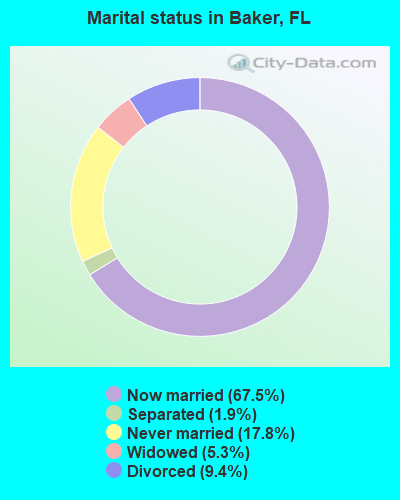
- Never married: 17.8%
- Now married: 67.5%
- Separated: 1.9%
- Widowed: 5.3%
- Divorced: 9.4%
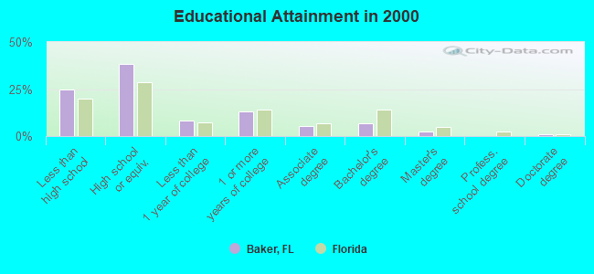
For population 25 years and over in Baker:
- High school or higher: 75.1%
- Bachelor's degree or higher: 10.6%
- Graduate or professional degree: 4.0%
- Unemployed: 6.1%
- Mean travel time to work (commute): 30.6 minutes
| Here: | 11.6 |
| Florida average: | 12.6 |
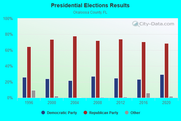
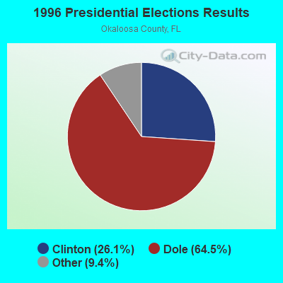
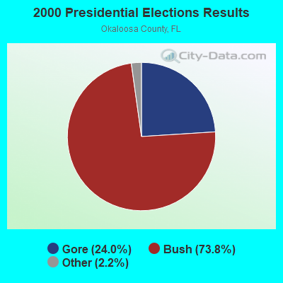
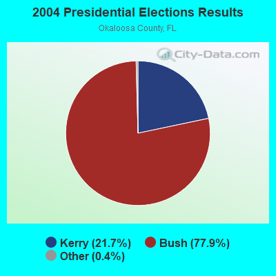
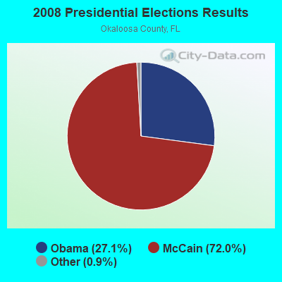
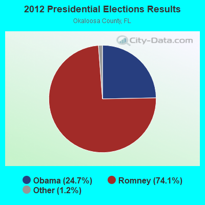
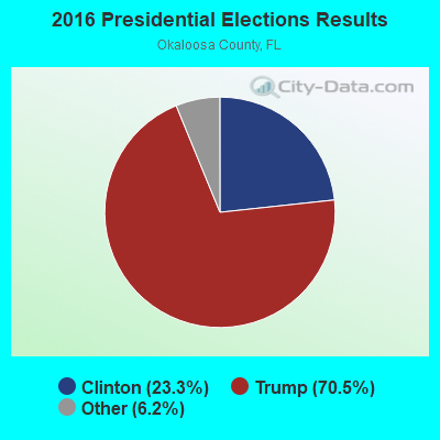

Graphs represent county-level data. Detailed 2008 Election Results
Religion statistics for Baker, FL (based on Okaloosa County data)
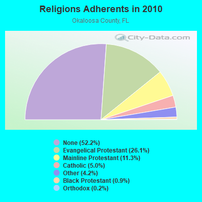
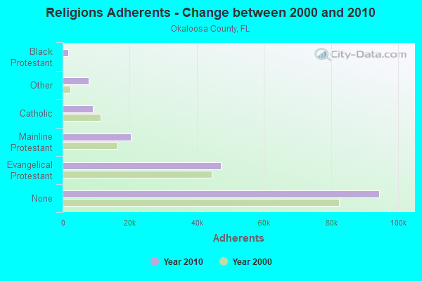
| Religion | Adherents | Congregations |
|---|---|---|
| Evangelical Protestant | 47,236 | 156 |
| Mainline Protestant | 20,414 | 26 |
| Catholic | 9,085 | 6 |
| Other | 7,666 | 22 |
| Black Protestant | 1,652 | 10 |
| Orthodox | 337 | 2 |
| None | 94,432 | - |
Food Environment Statistics:
| Okaloosa County: | 1.82 / 10,000 pop. |
| Florida: | 2.04 / 10,000 pop. |
| This county: | 0.22 / 10,000 pop. |
| Florida: | 0.11 / 10,000 pop. |
| This county: | 0.55 / 10,000 pop. |
| Florida: | 1.28 / 10,000 pop. |
| Okaloosa County: | 4.64 / 10,000 pop. |
| Florida: | 3.04 / 10,000 pop. |
| Okaloosa County: | 9.66 / 10,000 pop. |
| Florida: | 7.45 / 10,000 pop. |
| Okaloosa County: | 9.4% |
| Florida: | 9.2% |
| Okaloosa County: | 23.5% |
| Florida: | 23.7% |
| Okaloosa County: | 9.3% |
| State: | 14.0% |
11.40% of this county's 2021 resident taxpayers lived in other counties in 2020 ($70,863 average adjusted gross income)
| Here: | 11.40% |
| Florida average: | 8.80% |
0.42% of residents moved from foreign countries ($2,211 average AGI)
Okaloosa County: 0.42% Florida average: 0.05%
Top counties from which taxpayers relocated into this county between 2020 and 2021:
| from Santa Rosa County, FL | |
| from Walton County, FL | |
| from Escambia County, FL |
10.71% of this county's 2020 resident taxpayers moved to other counties in 2021 ($63,664 average adjusted gross income)
| Here: | 10.71% |
| Florida average: | 7.45% |
0.33% of residents moved to foreign countries ($1,951 average AGI)
Okaloosa County: 0.33% Florida average: 0.04%
Top counties to which taxpayers relocated from this county between 2020 and 2021:
| to Santa Rosa County, FL | |
| to Walton County, FL | |
| to Escambia County, FL |
Strongest AM radio stations in Baker:
- WJSB (1050 AM; 5 kW; CRESTVIEW, FL; Owner: CRESTVIEW BROADCASTING CO., INC.)
- WEBY (1330 AM; 25 kW; MILTON, FL; Owner: SPINNAKER LICENSE CORPORATION)
- WASG (550 AM; 25 kW; ATMORE, AL; Owner: 550 AM, INC)
- WNVY (1090 AM; daytime; 10 kW; CANTONMENT, FL; Owner: 1090-AM INC.)
- WZEP (1460 AM; 10 kW; DEFUNIAK SPRINGS, FL; Owner: WALTON COUNTY BROADCASTING, INC.)
- WGTX (1280 AM; 5 kW; DE FUNIAK SPRINGS, FL)
- WBZR (1120 AM; daytime; 2 kW; DESTIN, FL; Owner: DESTINY COMMUNICATIONS CORP.)
- WDLT (660 AM; 10 kW; FAIRHOPE, AL; Owner: CUMULUS LICENSING CORP.)
- WFTW (1260 AM; 2 kW; FORT WALTON BEACH, FL; Owner: CUMULUS LICENSING CORP.)
- WRNE (980 AM; 2 kW; GULF BREEZE, FL; Owner: MEDIA ONE COMMUNICATIONS, INC.)
- WBCA (1110 AM; daytime; 10 kW; BAY MINETTE, AL; Owner: SOUTHERN MEDIA COMMUNICATIONS, INC)
- WJOX (690 AM; 50 kW; BIRMINGHAM, AL; Owner: CITADEL BROADCASTING COMPANY)
- WCOA (1370 AM; 5 kW; PENSACOLA, FL; Owner: CUMULUS LICENSING CORP.)
Strongest FM radio stations in Baker:
- WTJT (90.1 FM; BAKER, FL; Owner: OKALOOSA PUBLIC RADIO, INC.)
- WZNS (96.5 FM; FORT WALTON BEACH, FL; Owner: CUMULUS LICENSING CORP.)
- WTKE (98.1 FM; HOLT, FL; Owner: CAPSTAR TX LIMITED PARTNERSHIP)
- WAAZ-FM (104.7 FM; CRESTVIEW, FL; Owner: CRESTVIEW BROADCASTING COMPANY, INC.)
- WTKX-FM (101.5 FM; PENSACOLA, FL; Owner: CLEAR CHANNEL BROADCASTING LICENSES, INC.)
- WXBM-FM (102.7 FM; MILTON, FL; Owner: 6 JOHNSON ROAD LICENSES, INC.)
- WKSM (99.5 FM; FORT WALTON BEACH, FL; Owner: CUMULUS LICENSING CORP.)
- WYCL (107.3 FM; PENSACOLA, FL; Owner: CONCORD MEDIA GROUP, INC.)
- WKSJ-FM (94.9 FM; MOBILE, AL; Owner: CLEAR CHANNEL BROADCASTING LICENSES, INC.)
- WUWF (88.1 FM; PENSACOLA, FL; Owner: THE UNIVERSITY OF WEST FLORIDA)
- WEGS (91.7 FM; MILTON, FL; Owner: FLORIDA PUBLIC RADIO, INC.)
- WNCV (100.3 FM; NICEVILLE, FL; Owner: CUMULUS LICENSING CORP.)
- WKNU (106.3 FM; BREWTON, AL; Owner: ELLINGTON RADIO, INC.)
TV broadcast stations around Baker:
- WSRE (Channel 23; PENSACOLA, FL; Owner: DST .BD. OF TRUSTEES PENSACOLA JR. COLLEGE)
- WEAR-TV (Channel 3; PENSACOLA, FL; Owner: WEAR LICENSEE, LLC)
- WJTC (Channel 44; PENSACOLA, FL; Owner: CLEAR CHANNEL BROADCASTING LICENSES, INC.)
- WPMI (Channel 15; MOBILE, AL; Owner: CLEAR CHANNEL BROADCASTING LICENSES, INC.)
- WMPV-TV (Channel 21; MOBILE, AL; Owner: TRINITY BROADCASTING NETWORK)
- WTVY (Channel 4; DOTHAN, AL; Owner: GRAY MIDAMERICA TV LICENSEE CORP.)
- W69DH (Channel 69; PANAMA CITY, FL; Owner: RICHARD & LISA GOETZ)
- WPAN (Channel 53; FORT WALTON BEACH, FL; Owner: FRANKLIN MEDIA, INC.)
- W26BV (Channel 26; PANAMA CITY, FL; Owner: RICHARD C. & LISA A. GOETZ)
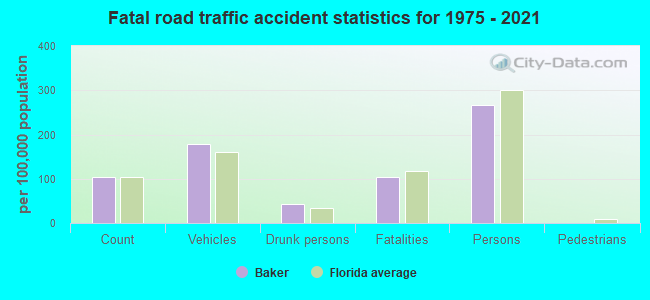
Baker fatal accident list:
Feb 10, 1996 03:10 PM, Sr 4, Vehicles: 2, Persons: 3, Fatalities: 1
Jul 28, 1989 09:05 PM, Sr4, Vehicles: 1, Persons: 2, Fatalities: 1
Oct 26, 1983 07:05 PM, 189, Vehicles: 1, Persons: 1, Fatalities: 1
Dec 17, 1983 02:35 PM, 189, Vehicles: 2, Persons: 4, Fatalities: 1, Drunk persons involved: 1
Jan 25, 1981 02:10 AM, Vehicles: 1, Persons: 1, Fatalities: 1, Drunk persons involved: 1
Jun 20, 1981 02:20 AM, Vehicles: 1, Persons: 1, Fatalities: 1, Drunk persons involved: 1
FCC Registered Cell Phone Towers:
4 (See the full list of FCC Registered Cell Phone Towers in Baker)FCC Registered Antenna Towers:
61 (See the full list of FCC Registered Antenna Towers)FCC Registered Broadcast Land Mobile Towers:
5- 6462 State Road 189 (Lat: 30.845333 Lon: -86.675833), Type: Tank, Structure height: 36.5 m, Call Sign: WPHP604,
Assigned Frequencies: 159.142 MHz, 152.007 MHz, 157.450 MHz, Grant Date: 05/19/2015, Expiration Date: 06/21/2025, Certifier: George Collins, Registrant: Bakers Communication Inc, 2627 Sw Main Blvd, Lake City, FL 32056, Phone: (386) 752-6494, Fax: (386) 752-6493, Email:
- Lat: 30.749194 Lon: -86.632944, Call Sign: WNQM942,
Assigned Frequencies: 153.350 MHz, 467.925 MHz, 467.900 MHz, 467.875 MHz, 467.850 MHz, Grant Date: 09/23/2014, Expiration Date: 10/06/2024, Certifier: Richard D Creel, Registrant: Washington Radio Reports, Gettysburg, PA 17325, Phone: (717) 334-0668, Fax: (717) 334-6440
- 5306t Fox Hound Lane (Lat: 30.752806 Lon: -86.661750), Type: Pole, Structure height: 6.1 m, Overall height: 7.6 m, Call Sign: WQKZ211,
Assigned Frequencies: 451.875 MHz, Grant Date: 09/13/2019, Expiration Date: 11/02/2029, Certifier: Martin W Ellis, Registrant: Atlas License Company & Data Services, 7202 N. Shadeland Ave Ste 215, Indianapolis, IN 46250, Phone: (317) 813-4865, Fax: (317) 813-4870, Email:
- BLACKMAN, Off County Road 2 (Lat: 30.924667 Lon: -86.635278), Type: Ltower, Structure height: 91.4 m, Overall height: 98.5 m, Call Sign: WRYX350, Licensee ID: L00017290,
Assigned Frequencies: 854.875 MHz, 856.150 MHz, 857.012 MHz, Grant Date: 09/28/2023, Expiration Date: 09/28/2033, Certifier: Daniel Dunlap, Registrant: County Of Okaloosa, 90 College Blvd East, Shalimar, FL 32579, Phone: (850) 689-5607, Email:
- BLACKMAN, Off County Road 2 (Lat: 30.924667 Lon: -86.635278), Type: Ltower, Structure height: 91.4 m, Overall height: 98.5 m, Call Sign: WRZD657,
Assigned Frequencies: 857.725 MHz, 858.000 MHz, 858.225 MHz, 858.250 MHz, Grant Date: 10/20/2023, Expiration Date: 10/20/2033, Certifier: Daniel Dunlop, Registrant: County Of Okaloosa, 90 College Blvd East, Niceville, FL 32579, Phone: (850) 689-5607, Fax: (850) 689-5608, Email:
FCC Registered Microwave Towers:
11 (See the full list of FCC Registered Microwave Towers in this town)FCC Registered Amateur Radio Licenses:
45 (See the full list of FCC Registered Amateur Radio Licenses in Baker)FAA Registered Aircraft Manufacturers and Dealers:
1 (See the full list of FAA Registered Manufacturers and Dealers in Baker)FAA Registered Aircraft:
20 (See the full list of FAA Registered Aircraft)2002 - 2018 National Fire Incident Reporting System (NFIRS) incidents
- Fire incident types reported to NFIRS in Baker, FL
- 20943.3%Outside Fires
- 20141.6%Structure Fires
- 438.9%Mobile Property/Vehicle Fires
- 306.2%Other
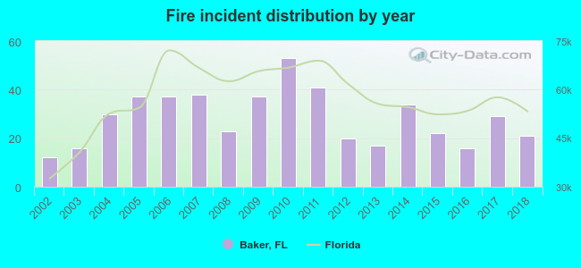 Based on the data from the years 2002 - 2018 the average number of fire incidents per year is 28. The highest number of reported fires - 53 took place in 2010, and the least - 12 in 2002. The data has an increasing trend.
 When looking into fire subcategories, the most reports belonged to: Outside Fires (43.3%), and Structure Fires (41.6%).
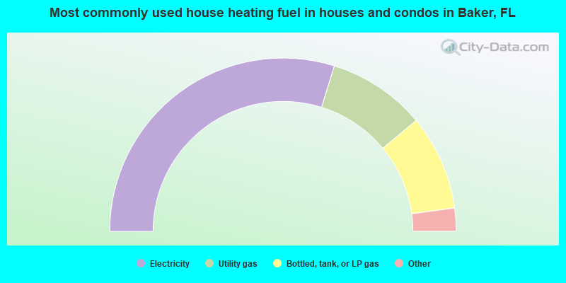
- 59.6%Electricity
- 18.3%Utility gas
- 17.8%Bottled, tank, or LP gas
- 3.8%Wood
- 0.5%Other fuel
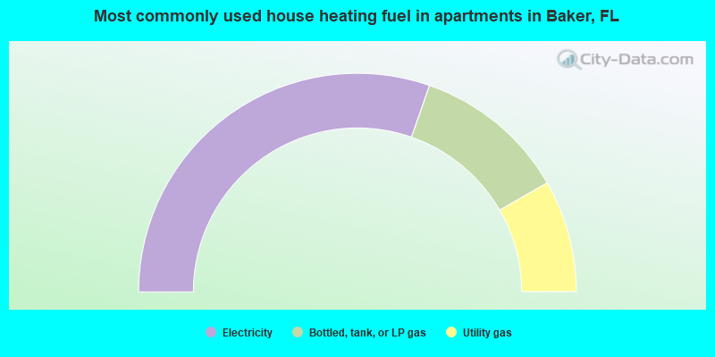
- 60.7%Electricity
- 22.7%Bottled, tank, or LP gas
- 16.6%Utility gas
Baker compared to Florida state average:
- Median house value below state average.
- Unemployed percentage below state average.
- Black race population percentage significantly below state average.
- Hispanic race population percentage significantly below state average.
- Foreign-born population percentage significantly below state average.
- Renting percentage below state average.
- Length of stay since moving in significantly above state average.
- Number of rooms per house significantly below state average.
- House age significantly below state average.
- Number of college students below state average.
- Percentage of population with a bachelor's degree or higher significantly below state average.
Baker on our top lists:
- #2 on the list of "Top 101 cities with largest percentage of females in occupations: other transportation workers (population 5,000+)"
- #4 on the list of "Top 101 cities with largest percentage of females in occupations: fishing and hunting, and forest and logging workers (population 5,000+)"
- #4 on the list of "Top 101 cities with largest percentage of females in occupations: food and beverage serving workers except waiters/waitresses (population 5,000+)"
- #4 on the list of "Top 101 cities with largest percentage of females in industries: pharmacies and drug stores (population 5,000+)"
- #5 on the list of "Top 101 cities with the most residents born in Polynesia (population 500+)"
- #5 on the list of "Top 101 cities with the most residents born in United Kingdom (population 500+)"
- #5 on the list of "Top 101 cities with the most residents born in Yugoslavia (population 500+)"
- #5 on the list of "Top 101 cities with the most residents born in Asia, n.e.c. (population 500+)"
- #5 on the list of "Top 101 cities with the most residents born in Melanesia (population 500+)"
- #5 on the list of "Top 101 cities with the most residents born in Micronesia (population 500+)"
- #10 on the list of "Top 101 cities with largest percentage of females in occupations: financial clerks except bookkeeping, accounting, and auditing clerks (population 5,000+)"
- #10 on the list of "Top 101 cities with largest percentage of females in occupations: judges, magistrates, and other judicial workers (population 5,000+)"
- #10 on the list of "Top 101 cities with largest percentage of females in occupations: mathematical science occupations (population 5,000+)"
- #16 on the list of "Top 101 cities with largest percentage of males in industries: building material and garden equipment and supplies dealers (population 5,000+)"
- #16 on the list of "Top 101 cities with largest percentage of males in industries: religious, grantmaking, civic, professional, and similar organizations (population 5,000+)"
- #25 on the list of "Top 101 cities with largest percentage of males in industries: motor vehicles, parts and supplies merchant wholesalers (population 5,000+)"
- #31 on the list of "Top 101 cities with largest percentage of males in industries: hardware, plumbing and heating equipment, and supplies merchant wholesalers (population 5,000+)"
- #35 on the list of "Top 101 cities with largest percentage of males in industries: furniture and home furnishings, and household appliance stores (population 5,000+)"
- #82 on the list of "Top 101 cities with largest percentage of females in industries: textile mills and textile products (population 5,000+)"
- #99 on the list of "Top 101 cities with largest percentage of females in industries: miscellaneous nondurable goods merchant wholesalers (population 5,000+)"
- #22 on the list of "Top 101 counties with the highest percentage of residents relocating from foreign countries between 2010 and 2011"
- #25 on the list of "Top 101 counties with the highest percentage of residents relocating to foreign countries in 2011"
- #49 on the list of "Top 101 counties with highest percentage of residents voting for Romney (Republican) in the 2012 Presidential Election (pop. 50,000+)"
- #52 on the list of "Top 101 counties with the highest percentage of residents relocating from other counties between 2010 and 2011 (pop. 50,000+)"
- #54 on the list of "Top 101 counties with the largest increase in the number of births per 1000 residents 2000-2006 to 2007-2013 (pop 50,000+)"

|
Total of 2 patent applications in 2008-2024.