Bethlehem, New York
Submit your own pictures of this town and show them to the world
- OSM Map
- Google Map
- MSN Map
Population change since 2000: +7.5%
 |
| Males: 16,144 | |
| Females: 17,512 |
| Median resident age: | 43.6 years |
| New York median age: | 40.7 years |
Zip codes: 12054.
| Bethlehem: | $113,360 |
| NY: | $79,557 |
Estimated per capita income in 2022: $60,693 (it was $31,492 in 2000)
Bethlehem town income, earnings, and wages data
Estimated median house or condo value in 2022: $346,403 (it was $143,300 in 2000)
| Bethlehem: | $346,403 |
| NY: | $400,400 |
Mean prices in 2022: all housing units: $311,969; detached houses: $333,344; townhouses or other attached units: $251,700; in 2-unit structures: $215,501; in 3-to-4-unit structures: $169,123; in 5-or-more-unit structures: $355,917; mobile homes: $192,367
Detailed information about poverty and poor residents in Bethlehem, NY
Compare current foreclosures near Bethlehem, NY:
| Photo | Address | Area | Beds / Baths | Price | Details |
|---|---|---|---|---|---|

|
#1
N Allen St
Albany, NY 12206
|
2,464 sq. feet
|
2 baths 6 beds |
$74,900
|
show details |

|
#2
Wilkins Ave
Albany, NY 12205
|
638 sq. feet
|
1 baths 2 beds |
$189,900
|
show details |

|
#3
New Scotland Rd
Voorheesville, NY 12186
|
2,319 sq. feet
|
2 baths 4 beds |
$149,900
|
show details |

|
#4
Mann Avenue & 12 Elm Street
Cohoes, NY 12047
|
1,864 sq. feet
|
2 baths 4 beds |
show details | |

|
#5
Everett Rd
Albany, NY 12205
|
1,428 sq. feet
|
2 baths 3 beds |
show details | |

|
#6
Mumford St
Schenectady, NY 12307
|
2,260 sq. feet
|
2 baths 6 beds |
show details | |

|
#7
New Turnpike Rd
Troy, NY 12182
|
981 sq. feet
|
1 baths 3 beds |
show details | |

|
#8
Lawrence St
Waterford, NY 12188
|
2,200 sq. feet
|
1 baths 2 beds |
show details | |

|
#9
Hudson St
Waterford, NY 12188
|
1,764 sq. feet
|
2 baths 4 beds |
show details | |

|
#10
Old Loudon Rd
Latham, NY 12110
|
1,176 sq. feet
|
1 baths 3 beds |
show details |
| Photo | Address | Area | Beds / Baths | Price | Details |
|---|---|---|---|---|---|

|
#11
Hendricks St
Schenectady, NY 12306
|
1,632 sq. feet
|
1 baths 3 beds |
show details | |

|
#12
Willett St
Schenectady, NY 12303
|
1,944 sq. feet
|
2 baths 4 beds |
show details | |

|
#13
Marion Blvd
Valatie, NY 12184
|
1,180 sq. feet
|
2 baths 3 beds |
show details | |

|
#14
Sumpter St
Albany, NY 12205
|
1,816 sq. feet
|
1 baths 1 beds |
show details | |

|
#15
5th Ave
Watervliet, NY 12189
|
2,024 sq. feet
|
1 baths 2 beds |
show details | |

|
#16
County Road 402
Westerlo, NY 12193
|
- sq. feet
|
1 baths 2 beds |
show details | |

|
#17
Cpl William Dickerson Place Aka 19 Cpl William A. Dickerson Place
Troy, NY 12180
|
1,704 sq. feet
|
2 baths 4 beds |
show details | |

|
#18
Floral Ave
Schenectady, NY 12306
|
1,446 sq. feet
|
1 baths 3 beds |
show details | |

|
#19
George St
Troy, NY 12183
|
2,200 sq. feet
|
2 baths 6 beds |
show details | |

|
#20
Ray Ave
Schenectady, NY 12304
|
1,780 sq. feet
|
2 baths 3 beds |
show details |
| Photo | Address | Area | Beds / Baths | Price | Details |
|---|---|---|---|---|---|

|
#21
4th Ave
Troy, NY 12182
|
872 sq. feet
|
1 baths 3 beds |
show details | |

|
#22
2nd St
Albany, NY 12206
|
945 sq. feet
|
1 baths 2 beds |
show details | |

|
#23
2nd Ave
Rensselaer, NY 12144
|
1,648 sq. feet
|
1 baths 3 beds |
show details | |

|
#24
Melrose Ave
Albany, NY 12203
|
1,378 sq. feet
|
1 baths 3 beds |
show details | |

|
#25
Vliet Blvd
Cohoes, NY 12047
|
2,550 sq. feet
|
2 baths 6 beds |
show details | |

|
#26
Northern Dr
Troy, NY 12182
|
1,092 sq. feet
|
1 baths 2 beds |
show details | |

|
#27
Arcadia Ct
Albany, NY 12205
|
1,692 sq. feet
|
1 baths 4 beds |
show details | |

|
#28
Midway Dr
Albany, NY 12205
|
1,296 sq. feet
|
1 baths 3 beds |
show details | |

|
#29
New Scotland Rd
Slingerlands, NY 12159
|
1,904 sq. feet
|
3 baths 4 beds |
show details | |

|
#30
Jarvis Rd S
Ravena, NY 12143
|
1,431 sq. feet
|
2 baths 3 beds |
show details |
| Photo | Address | Area | Beds / Baths | Price | Details |
|---|---|---|---|---|---|

|
#31
Alva Dr
Latham, NY 12110
|
1,104 sq. feet
|
1 baths 3 beds |
show details | |

|
#32
Southern Blvd
Albany, NY 12209
|
2,264 sq. feet
|
2 baths 6 beds |
show details | |

|
#33
Cambridge Ct
Clifton Park, NY 12065
|
1,924 sq. feet
|
1 baths 3 beds |
show details | |

|
#34
Maxwell Dr
Schenectady, NY 12309
|
1,670 sq. feet
|
2 baths 3 beds |
show details | |

|
#35
Tollgate Rd
Averill Park, NY 12018
|
2,088 sq. feet
|
2 baths 3 beds |
show details | |

|
#36
Woodlawn Ave
Schenectady, NY 12304
|
936 sq. feet
|
1 baths 4 beds |
show details | |

|
#37
Sharpe Rd
Wynantskill, NY 12198
|
2,626 sq. feet
|
2 baths 4 beds |
show details | |

|
#38
Westbrook Dr
Nassau, NY 12123
|
768 sq. feet
|
1 baths 2 beds |
show details | |

|
#39
Fort Hunter Rd
Schenectady, NY 12303
|
1,317 sq. feet
|
1 baths 2 beds |
show details | |

|
#40
Western Tpke
Altamont, NY 12009
|
1,242 sq. feet
|
1 baths 3 beds |
show details |
| Photo | Address | Area | Beds / Baths | Price | Details |
|---|---|---|---|---|---|

|
#41
Cassella Rd
Schenectady, NY 12303
|
1,176 sq. feet
|
1 baths 3 beds |
show details | |

|
#42
Park Ave
Nassau, NY 12123
|
1,734 sq. feet
|
1 baths 3 beds |
show details | |

|
#43
Lishakill Rd
Schenectady, NY 12309
|
1,797 sq. feet
|
1 baths 3 beds |
show details | |

|
#44
Barrington Ct
Schenectady, NY 12309
|
2,971 sq. feet
|
2 baths 4 beds |
show details | |

|
#45
Cohoes Rd
Watervliet, NY 12189
|
1,080 sq. feet
|
1 baths 3 beds |
show details | |

|
#46
Manchester Rd
Schenectady, NY 12304
|
676 sq. feet
|
1 baths 2 beds |
show details | |

|
#47
Corina Ct
Watervliet, NY 12189
|
1,200 sq. feet
|
1 baths 3 beds |
show details | |

|
#48
Corina Ct
Watervliet, NY 12189
|
1,200 sq. feet
|
1 baths 3 beds |
show details | |

|
#49
State Route 158 # 2
Altamont, NY 12009
|
3,632 sq. feet
|
2 baths 5 beds |
show details | |

|
Check over 1 million property listings on Foreclosure.com!
|
browse all offers | |||

- 30,31490.1%White alone
- 1,0603.1%Asian alone
- 8962.7%Hispanic
- 8282.5%Black alone
- 4771.4%Two or more races
- 390.1%American Indian alone
- 380.1%Other race alone
- 40.01%Native Hawaiian and Other
Pacific Islander alone
Races in Bethlehem detailed stats: ancestries, foreign born residents, place of birth
Type |
2009 |
2010 |
2011 |
2012 |
2013 |
2014 |
2015 |
2016 |
2017 |
2018 |
2019 |
2020 |
2021 |
2022 |
|---|---|---|---|---|---|---|---|---|---|---|---|---|---|---|
| Murders (per 100,000) | 0 (0.0) | 0 (0.0) | 0 (0.0) | 0 (0.0) | 0 (0.0) | 0 (0.0) | 0 (0.0) | 0 (0.0) | 0 (0.0) | 0 (0.0) | 0 (0.0) | 1 (2.9) | 1 (2.9) | 0 (0.0) |
| Rapes (per 100,000) | 2 (6.0) | 6 (17.8) | 5 (14.8) | 2 (5.9) | 0 (0.0) | 9 (26.0) | 12 (34.3) | 11 (31.3) | 5 (14.0) | 8 (22.4) | 11 (31.2) | 7 (20.0) | 5 (14.3) | 6 (17.2) |
| Robberies (per 100,000) | 6 (18.0) | 1 (3.0) | 6 (17.7) | 2 (5.9) | 3 (8.8) | 6 (17.3) | 2 (5.7) | 2 (5.7) | 3 (8.4) | 3 (8.4) | 2 (5.7) | 3 (8.6) | 4 (11.5) | 5 (14.3) |
| Assaults (per 100,000) | 22 (66.1) | 13 (38.6) | 15 (44.4) | 12 (35.5) | 10 (29.2) | 21 (60.6) | 11 (31.5) | 9 (25.6) | 11 (30.9) | 16 (44.8) | 16 (45.4) | 15 (42.8) | 12 (34.4) | 9 (25.8) |
| Burglaries (per 100,000) | 81 (243.3) | 87 (258.5) | 92 (272.1) | 64 (189.6) | 50 (146.0) | 58 (167.4) | 58 (166.0) | 53 (150.8) | 43 (120.8) | 28 (78.4) | 41 (116.2) | 25 (71.3) | 23 (65.8) | 22 (63.1) |
| Thefts (per 100,000) | 451 (1,355) | 399 (1,186) | 406 (1,201) | 402 (1,191) | 388 (1,133) | 385 (1,111) | 394 (1,127) | 409 (1,164) | 437 (1,227) | 465 (1,302) | 391 (1,108) | 346 (987.5) | 271 (775.9) | 350 (1,004) |
| Auto thefts (per 100,000) | 9 (27.0) | 9 (26.7) | 16 (47.3) | 3 (8.9) | 4 (11.7) | 11 (31.7) | 9 (25.8) | 6 (17.1) | 7 (19.7) | 5 (14.0) | 6 (17.0) | 9 (25.7) | 10 (28.6) | 13 (37.3) |
| Arson (per 100,000) | 1 (3.0) | 1 (3.0) | 4 (11.8) | 0 (0.0) | 0 (0.0) | 3 (8.7) | 1 (2.9) | 0 (0.0) | 0 (0.0) | 0 (0.0) | 0 (0.0) | 0 (0.0) | 0 (0.0) | 4 (11.5) |
| City-Data.com crime index | 96.8 | 90.5 | 96.9 | 75.2 | 64.9 | 96.8 | 94.3 | 90.3 | 79.1 | 88.1 | 89.6 | 79.4 | 65.4 | 70.8 |
The City-Data.com crime index weighs serious crimes and violent crimes more heavily. Higher means more crime, U.S. average is 246.1. It adjusts for the number of visitors and daily workers commuting into cities.
Crime rate in Bethlehem detailed stats: murders, rapes, robberies, assaults, burglaries, thefts, arson
Full-time law enforcement employees in 2020, including police officers: 53 (38 officers - 33 male; 5 female).
| Officers per 1,000 residents here: | 1.08 |
| New York average: | 3.38 |
 Recent articles from our blog. Our writers, many of them Ph.D. graduates or candidates, create easy-to-read articles on a wide variety of topics.
Ancestries: Irish (24.3%), German (21.5%), Italian (16.0%), English (13.7%), Polish (6.2%), French (5.0%).
Current Local Time: EST time zone
Incorporated in 1793
Land area: 48.8 square miles.
Population density: 690 people per square mile (low).
1,508 residents are foreign born (2.2% Europe, 1.5% Asia, 0.6% Latin America, 0.5% North America).
| This town: | 4.8% |
| New York: | 20.4% |
| Bethlehem town: | 2.3% ($3,267) |
| New York: | 1.9% ($2,847) |
Nearest city with pop. 50,000+: Albany, NY  (4.6 miles , pop. 95,658).
Nearest city with pop. 200,000+: Bronx, NY (121.4 miles , pop. 1,332,650).
Nearest cities:
), ), ), ), )Latitude: 42.60 N, Longitude: 73.83 W
Area code commonly used in this area: 518
Bethlehem, New York accommodation & food services, waste management - Economy and Business Data
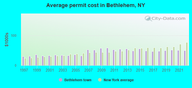
Single-family new house construction building permits:
- 2022: 30 buildings, average cost: $250,400
- 2021: 61 buildings, average cost: $255,600
- 2020: 70 buildings, average cost: $259,500
- 2019: 75 buildings, average cost: $250,700
- 2018: 67 buildings, average cost: $240,300
- 2017: 67 buildings, average cost: $234,000
- 2016: 94 buildings, average cost: $245,500
- 2015: 58 buildings, average cost: $276,900
- 2014: 58 buildings, average cost: $245,300
- 2013: 33 buildings, average cost: $277,800
- 2012: 40 buildings, average cost: $272,700
- 2011: 22 buildings, average cost: $263,200
- 2010: 32 buildings, average cost: $292,500
- 2009: 44 buildings, average cost: $287,000
- 2008: 46 buildings, average cost: $257,200
- 2007: 64 buildings, average cost: $261,800
- 2006: 71 buildings, average cost: $163,400
- 2005: 95 buildings, average cost: $179,900
- 2004: 140 buildings, average cost: $167,600
- 2003: 151 buildings, average cost: $172,600
- 2002: 168 buildings, average cost: $174,700
- 2001: 170 buildings, average cost: $165,100
- 2000: 189 buildings, average cost: $161,900
- 1999: 188 buildings, average cost: $180,400
- 1998: 165 buildings, average cost: $153,900
- 1997: 119 buildings, average cost: $151,700
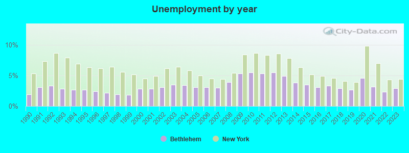
| Here: | 2.9% |
| New York: | 4.4% |
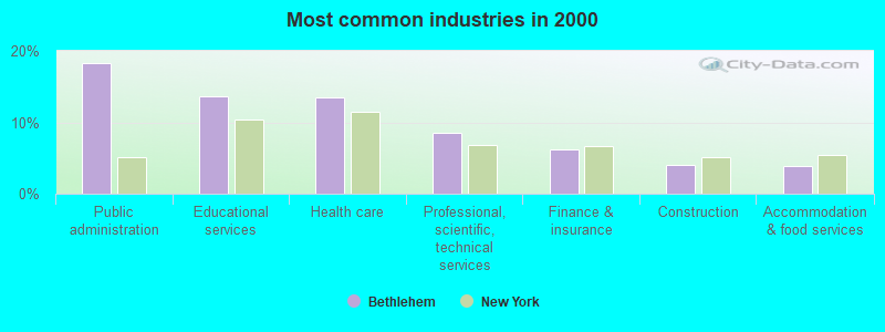
- Public administration (18.3%)
- Educational services (13.7%)
- Health care (13.4%)
- Professional, scientific, technical services (8.5%)
- Finance & insurance (6.2%)
- Construction (4.1%)
- Accommodation & food services (3.8%)
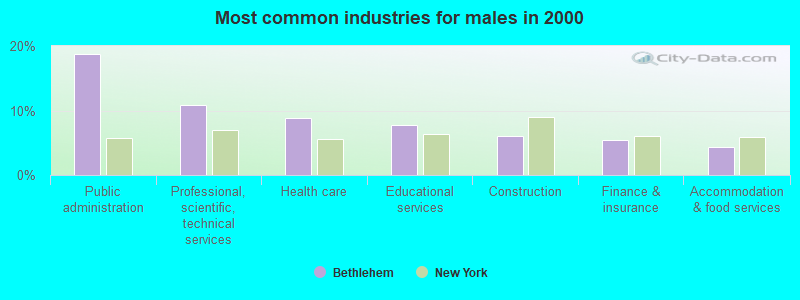
- Public administration (18.8%)
- Professional, scientific, technical services (10.8%)
- Health care (8.8%)
- Educational services (7.7%)
- Construction (6.0%)
- Finance & insurance (5.4%)
- Accommodation & food services (4.3%)
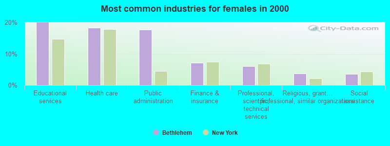
- Educational services (20.0%)
- Health care (18.3%)
- Public administration (17.7%)
- Finance & insurance (7.1%)
- Professional, scientific, technical services (6.1%)
- Religious, grantmaking, civic, professional, similar organizations (3.8%)
- Social assistance (3.5%)
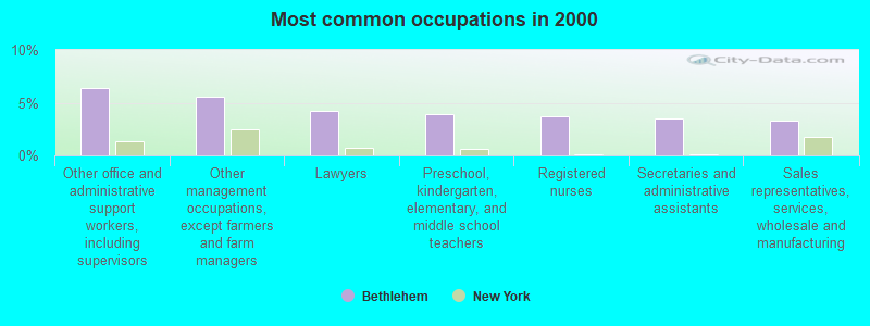
- Other office and administrative support workers, including supervisors (6.3%)
- Other management occupations, except farmers and farm managers (5.6%)
- Lawyers (4.2%)
- Preschool, kindergarten, elementary, and middle school teachers (4.0%)
- Registered nurses (3.7%)
- Secretaries and administrative assistants (3.5%)
- Sales representatives, services, wholesale and manufacturing (3.3%)
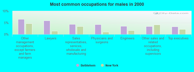
- Other management occupations, except farmers and farm managers (6.5%)
- Lawyers (5.9%)
- Sales representatives, services, wholesale and manufacturing (4.4%)
- Physicians and surgeons (4.3%)
- Engineers (3.5%)
- Other sales and related occupations, including supervisors (3.4%)
- Top executives (3.3%)
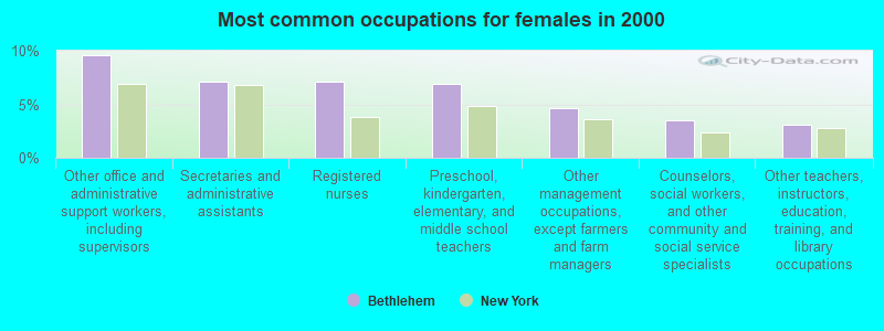
- Other office and administrative support workers, including supervisors (9.5%)
- Secretaries and administrative assistants (7.1%)
- Registered nurses (7.1%)
- Preschool, kindergarten, elementary, and middle school teachers (6.9%)
- Other management occupations, except farmers and farm managers (4.7%)
- Counselors, social workers, and other community and social service specialists (3.5%)
- Other teachers, instructors, education, training, and library occupations (3.1%)
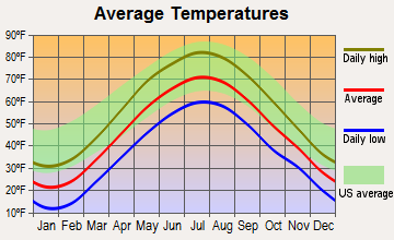
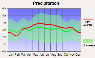
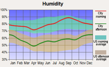
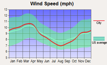
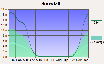
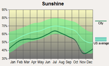
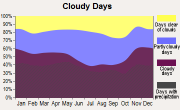
Average climate in Bethlehem, New York
Based on data reported by over 4,000 weather stations
(lower is better)
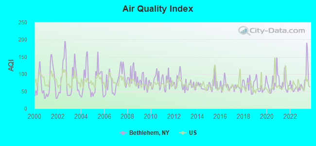
Air Quality Index (AQI) level in 2023 was 89.2. This is worse than average.
| City: | 89.2 |
| U.S.: | 72.6 |
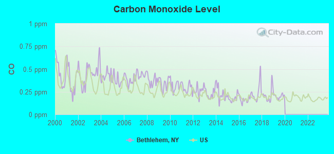
Carbon Monoxide (CO) [ppm] level in 2019 was 0.199. This is better than average. Closest monitor was 4.2 miles away from the city center.
| City: | 0.199 |
| U.S.: | 0.251 |
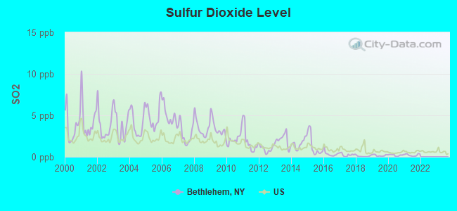
Sulfur Dioxide (SO2) [ppb] level in 2021 was 0.213. This is significantly better than average. Closest monitor was 3.8 miles away from the city center.
| City: | 0.213 |
| U.S.: | 1.515 |
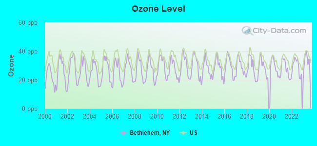
Ozone [ppb] level in 2023 was 32.1. This is about average. Closest monitor was 4.2 miles away from the city center.
| City: | 32.1 |
| U.S.: | 33.3 |
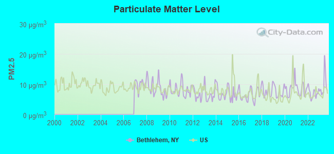
Particulate Matter (PM2.5) [µg/m3] level in 2023 was 9.66. This is about average. Closest monitor was 4.6 miles away from the city center.
| City: | 9.66 |
| U.S.: | 8.11 |
Tornado activity:
Bethlehem-area historical tornado activity is above New York state average. It is 41% smaller than the overall U.S. average.
On 7/10/1989, a category F4 (max. wind speeds 207-260 mph) tornado 18.5 miles away from the Bethlehem town center injured 20 people and caused between $5,000,000 and $50,000,000 in damages.
On 8/28/1973, a category F4 tornado 24.3 miles away from the town center killed 4 people and injured 36 people and caused between $5,000,000 and $50,000,000 in damages.
Earthquake activity:
Bethlehem-area historical earthquake activity is significantly above New York state average. It is 68% smaller than the overall U.S. average.On 10/7/1983 at 10:18:46, a magnitude 5.3 (5.1 MB, 5.3 LG, 5.1 ML, Class: Moderate, Intensity: VI - VII) earthquake occurred 97.0 miles away from the city center
On 4/20/2002 at 10:50:47, a magnitude 5.3 (5.3 ML, Depth: 3.0 mi) earthquake occurred 132.3 miles away from the city center
On 4/20/2002 at 10:50:47, a magnitude 5.2 (5.2 MB, 4.2 MS, 5.2 MW, 5.0 MW) earthquake occurred 130.5 miles away from the city center
On 1/19/1982 at 00:14:42, a magnitude 4.7 (4.5 MB, 4.7 MD, 4.5 LG, Class: Light, Intensity: IV - V) earthquake occurred 128.5 miles away from the city center
On 6/17/1991 at 08:53:16, a magnitude 4.1 (4.0 MB, 4.0 LG, Depth: 3.1 mi) earthquake occurred 43.4 miles away from Bethlehem center
On 10/16/2012 at 23:12:25, a magnitude 4.7 (4.7 ML, Depth: 10.0 mi) earthquake occurred 174.3 miles away from Bethlehem center
Magnitude types: regional Lg-wave magnitude (LG), body-wave magnitude (MB), duration magnitude (MD), local magnitude (ML), surface-wave magnitude (MS), moment magnitude (MW)
Natural disasters:
The number of natural disasters in Albany County (20) is greater than the US average (15).Major Disasters (Presidential) Declared: 10
Emergencies Declared: 9
Causes of natural disasters: Hurricanes: 4, Storms: 4, Winter Storms: 4, Floods: 3, Snowstorms: 3, Blizzards: 2, Power Outage: 1, Tropical Storm: 1, Other: 2 (Note: some incidents may be assigned to more than one category).
Hospitals and medical centers near Bethlehem:
- BETHLEHEM COMMONS CARE CENTER (Nursing Home, about 2 miles away; DELMAR, NY)
- ST MARGARETS CENTER (Nursing Home, about 4 miles away; ALBANY, NY)
- ALBANY MEDICAL CENTER / SOUTH CLINICAL CAMPUS (Hospital, about 4 miles away; ALBANY, NY)
- CHILDS NURSING HOME COMPANY INC (Nursing Home, about 4 miles away; ALBANY, NY)
- ST PETERS NURSING AND REHABILITATION CENTER (Nursing Home, about 4 miles away; ALBANY, NY)
- LIVING RESOURCES CORPORATION, INC (Hospital, about 4 miles away; ALBANY, NY)
- CATHOLIC CHARITIES OF THE DIOCESE OF ALBANY, INC (Hospital, about 4 miles away; ALBANY, NY)
Amtrak stations near Bethlehem:
- 6 miles: ALBANY-RENSSELAER (RENSSELAER, 555 EAST ST.) . Services: ticket office, partially wheelchair accessible, enclosed waiting area, public restrooms, public payphones, snack bar, ATM, free short-term parking, free long-term parking, call for car rental service, taxi stand, public transit connection.
- 16 miles: SCHENECTADY (332 ERIE BLVD.) . Services: ticket office, fully wheelchair accessible, enclosed waiting area, public restrooms, public payphones, vending machines, ATM, free short-term parking, free long-term parking, call for car rental service, taxi stand, public transit connection.
Colleges/universities with over 2000 students nearest to Bethlehem:
- The College of Saint Rose (about 5 miles; Albany, NY; Full-time enrollment: 4,085)
- SUNY at Albany (about 6 miles; Albany, NY; FT enrollment: 15,490)
- Excelsior College (about 8 miles; Albany, NY; FT enrollment: 4,723)
- Siena College (about 9 miles; Loudonville, NY; FT enrollment: 3,153)
- Hudson Valley Community College (about 10 miles; Troy, NY; FT enrollment: 9,346)
- The Sage Colleges (about 12 miles; Troy, NY; FT enrollment: 2,499)
- Rensselaer Polytechnic Institute (about 12 miles; Troy, NY; FT enrollment: 6,940)
Points of interest:
Notable locations in Bethlehem: Albany Filtration Plant (A), Glenmont Farms (B), Jericho Drive-In (C), Mallorys Corners (D), Meyers Corners (E), Normanside Country Club (F), Sleigh Bell Farm (G), Majestic Tree Farm (H), Selkirk Fire Company 3 (I), Selkirk Fire Department (J), Selkirk Fire Company 2 (K), Slingerlands Fire Department (L), Elsmere Fire District (M), North Bethlehem Fire Department (N), Delmar Fire District (O), Delmar Fire District Station 2 (P). Display/hide their locations on the map
Shopping Centers: Town Square Shopping Center (1), Glenmont Center Square Shopping Center (2), Delaware Plaza Shopping Center (3). Display/hide their locations on the map
Churches in Bethlehem include: Saint Thomas The Apostle Church (A), Saint Stephen's Episcopal Church (B), First United Methodist Church (C), First Church of Christ (D), Delmar Reformed Church (E), Delmar Presbyterian Church (F), Delmar Full Gospel Church (G), Bethlehem Lutheran Church (H), Bethlehem Community Church (I). Display/hide their locations on the map
Cemeteries: Saint Matthews Cemetery (1), Mount Pleasant Cemetery (2), Trinity Cemetery (3), Bethlehem Cemetery (4), Beth Emeth Cemetery (5), Elmwood Cemetery (6), Lady Help of Christian Cemetery (7). Display/hide their locations on the map
Lake: Frothingham Lake (A). Display/hide its location on the map
Streams, rivers, and creeks: Phillipin Kill (A), Dowers Kill (B), Vloman Kill (C), Onesquethaw Creek (D), Krum Kill (E), Island Creek (F). Display/hide their locations on the map
Park in Bethlehem: Elm Avenue Town Park (1). Display/hide its location on the map
Birthplace of: James A. McDougall - Politician.
Drinking water stations with addresses in Bethlehem that have no violations reported:
- BETHLEHEM WD NO 1 (Population served: 31,000, Primary Water Source Type: Surface water)
- HIDDEN MEADOWS GOLF (Population served: 50, Primary Water Source Type: Groundwater)
| This town: | 2.5 people |
| New York: | 2.6 people |
| This town: | 68.2% |
| Whole state: | 63.5% |
| This town: | 5.5% |
| Whole state: | 6.8% |
Likely homosexual households (counted as self-reported same-sex unmarried-partner households)
- Lesbian couples: 0.5% of all households
- Gay men: 0.3% of all households
| This town: | 3.1% |
| Whole state: | 14.6% |
| This town: | 1.6% |
| Whole state: | 7.4% |
People in group quarters in Bethlehem in 2010:
- 313 people in workers' group living quarters and job corps centers
- 177 people in nursing facilities/skilled-nursing facilities
- 69 people in group homes intended for adults
- 8 people in residential treatment centers for adults
People in group quarters in Bethlehem in 2000:
- 342 people in college dormitories (includes college quarters off campus)
- 203 people in nursing homes
- 76 people in homes for the mentally retarded
- 33 people in homes or halfway houses for drug/alcohol abuse
- 22 people in short-term care, detention or diagnostic centers for delinquent children
- 16 people in other group homes
- 10 people in training schools for juvenile delinquents
For population 15 years and over in Bethlehem:
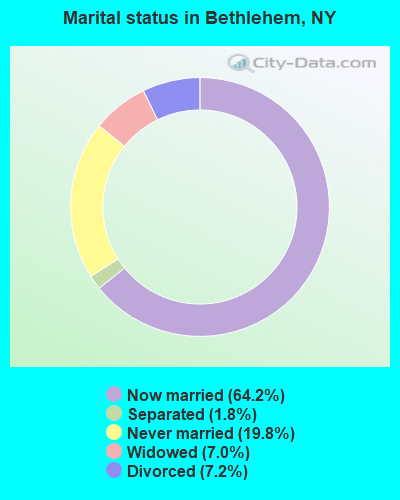
- Never married: 19.8%
- Now married: 64.2%
- Separated: 1.8%
- Widowed: 7.0%
- Divorced: 7.2%
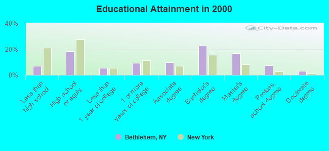
For population 25 years and over in Bethlehem:
- High school or higher: 93.1%
- Bachelor's degree or higher: 50.0%
- Graduate or professional degree: 27.3%
- Unemployed: 3.5%
- Mean travel time to work (commute): 20.3 minutes
| Here: | 11.4 |
| New York average: | 14.2 |
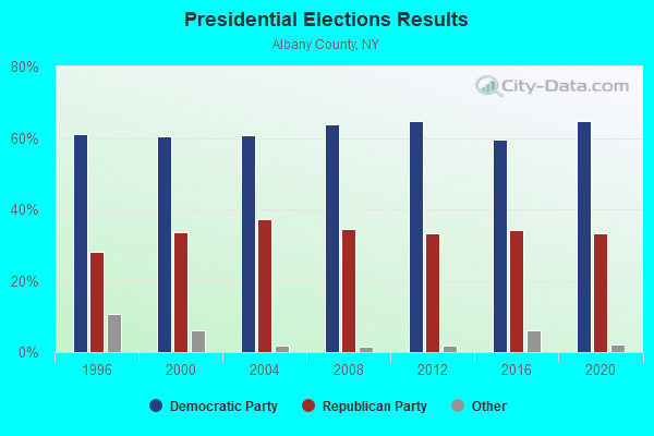
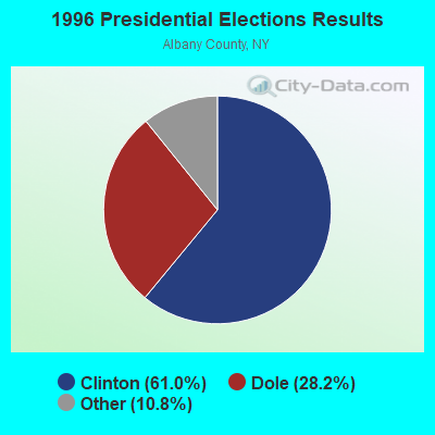
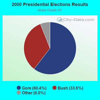
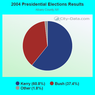
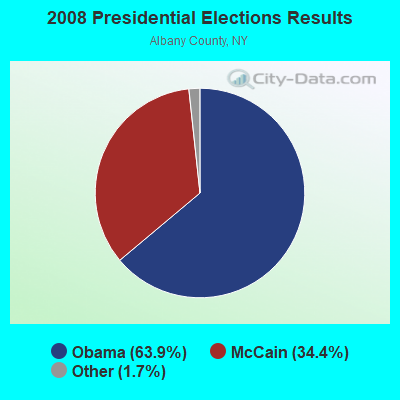
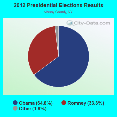
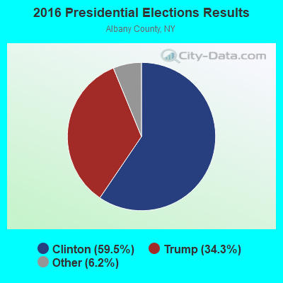
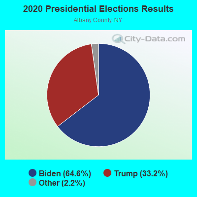
Graphs represent county-level data. Detailed 2008 Election Results
Religion statistics for Bethlehem, NY (based on Albany County data)
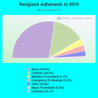
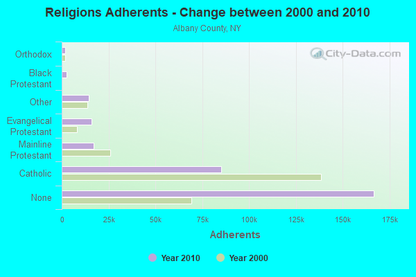
| Religion | Adherents | Congregations |
|---|---|---|
| Catholic | 85,267 | 29 |
| Mainline Protestant | 17,188 | 78 |
| Evangelical Protestant | 15,873 | 72 |
| Other | 14,472 | 31 |
| Black Protestant | 2,739 | 11 |
| Orthodox | 2,025 | 9 |
| None | 166,640 | - |
Food Environment Statistics:
| Albany County: | 2.51 / 10,000 pop. |
| State: | 4.13 / 10,000 pop. |
| Albany County: | 0.07 / 10,000 pop. |
| New York: | 0.06 / 10,000 pop. |
| Here: | 1.07 / 10,000 pop. |
| State: | 0.92 / 10,000 pop. |
| Albany County: | 3.15 / 10,000 pop. |
| New York: | 1.68 / 10,000 pop. |
| This county: | 10.15 / 10,000 pop. |
| New York: | 8.82 / 10,000 pop. |
| Albany County: | 7.8% |
| New York: | 8.2% |
| Albany County: | 25.6% |
| New York: | 23.8% |
| This county: | 14.0% |
| State: | 15.6% |
Businesses in Bethlehem, NY
- Subway: 1
Strongest AM radio stations in Bethlehem:
- WDDY (1460 AM; 5 kW; ALBANY, NY)
- WROW (590 AM; 5 kW; ALBANY, NY; Owner: 6 JOHNSON ROAD LICENSES, INC.)
- WPTR (1540 AM; 50 kW; ALBANY, NY; Owner: KIMTRON, INC.)
- WGY (810 AM; 50 kW; SCHENECTADY, NY; Owner: CLEAR CHANNEL BROADCASTING LICENSES, INC.)
- WTMM (1300 AM; 5 kW; RENSSELAER, NY; Owner: REGENT LICENSEE OF MANSFIELD, INC.)
- WOFX (980 AM; 5 kW; TROY, NY)
- WNNZ (640 AM; 50 kW; WESTFIELD, MA; Owner: CLEAR CHANNEL BROADCASTING LICENSES, INC.)
- WAMC (1400 AM; 1 kW; ALBANY, NY; Owner: WAMC)
- WABY (1160 AM; 5 kW; MECHANICVILLE, NY; Owner: ANASTOS MEDIA GROUP, INC.)
- WTIC (1080 AM; 50 kW; HARTFORD, CT; Owner: INFINITY RADIO OPERATIONS INC.)
- WCRN (830 AM; 50 kW; WORCESTER, MA; Owner: CARTER BROADCASTING CORPORATION)
- WUHN (1110 AM; daytime; 5 kW; PITTSFIELD, MA; Owner: WEINER BROADCASTING, INC.)
- WFAN (660 AM; 50 kW; NEW YORK, NY; Owner: INFINITY BROADCASTING OPERATIONS, INC.)
Strongest FM radio stations in Bethlehem:
- WQBK-FM (103.9 FM; RENSSELAER, NY; Owner: REGENT LICENSEE OF MANSFIELD, INC.)
- WAJZ (96.3 FM; VOORHEESVILLE, NY; Owner: 6 JOHNSON ROAD LICENSES, INC.)
- WRCZ (94.5 FM; RAVENA, NY; Owner: DOT COMMUNICATIONS, INC.)
- WYJB (95.5 FM; ALBANY, NY; Owner: 6 JOHNSON ROAD LICENSES, INC.)
- WGNA-FM (107.7 FM; ALBANY, NY; Owner: REGENT LICENSEE OF MANSFIELD, INC.)
- WZMR (104.9 FM; ALTAMONT, NY; Owner: 6 JOHNSON ROAD LICENSES, INC.)
- WRVE (99.5 FM; SCHENECTADY, NY; Owner: CLEAR CHANNEL BROADCASTING LICENSES, INC.)
- WMHT-FM (89.1 FM; SCHENECTADY, NY; Owner: WMHT EDUCATIONAL TELECOMMUNICATIONS)
- WPYX (106.5 FM; ALBANY, NY; Owner: CAPSTAR TX LIMITED PARTNERSHIP)
- WFLY (92.3 FM; TROY, NY; Owner: 6 JOHNSON ROAD LICENSES, INC.)
- WVCR-FM (88.3 FM; LOUDONVILLE, NY; Owner: SIENA COLLEGE)
- WRPI (91.5 FM; TROY, NY; Owner: RENSSELAER POLYTECHNIC INSTITUTE)
- WCDB (90.9 FM; ALBANY, NY; Owner: STATE UNIVERSITY OF NEW YORK)
- WAMC-FM (90.3 FM; ALBANY, NY; Owner: WAMC)
- WHRL (103.1 FM; ALBANY, NY; Owner: CLEAR CHANNEL BROADCASTING LICENSES, INC.)
- WZEC (97.5 FM; HOOSICK FALLS, NY; Owner: GREAT NORTHERN RADIO, LLC)
- WKLI-FM (100.9 FM; ALBANY, NY; Owner: 6 JOHNSON ROAD LICENSES, INC.)
- WMYY (97.3 FM; SCHOHARIE, NY; Owner: CAPITAL MEDIA CORPORATION)
- WHVP (91.1 FM; HUDSON, NY; Owner: SOUND OF LIFE, INC.)
- WEQX (102.7 FM; MANCHESTER, VT; Owner: NORTHSHIRE COMMUNICATIONS, INC.)
TV broadcast stations around Bethlehem:
- WRGB (Channel 6; SCHENECTADY, NY; Owner: FREEDOM BROADCASTING OF NEW YORK, INC)
- WNYT (Channel 13; ALBANY, NY; Owner: WNYT-TV, LLC)
- WTEN (Channel 10; ALBANY, NY; Owner: YOUNG BROADCASTING OF ALBANY, INC.)
- WMHT (Channel 17; SCHENECTADY, NY; Owner: WMHT EDUCATIONAL TELECOMMUNICATIONS)
- WEWB-TV (Channel 45; SCHENECTADY, NY; Owner: WEWB, L.L.C.)
- WXXA-TV (Channel 23; ALBANY, NY; Owner: CLEAR CHANNEL BROADCASTING LICENSES, INC.)
- W52DF (Channel 52; ALBANY, NY; Owner: TRINITY BROADCASTING NETWORK)
- WYPX (Channel 55; AMSTERDAM, NY; Owner: PAXSON ALBANY LICENSE, INC.)
- W58CX (Channel 58; SARATOGA SPRINGS, NY; Owner: THREE ANGELS BROADCASTING NETWORK)
- WVBG-LP (Channel 25; GREENWICH, NY; Owner: WIRELESS ACCESS, LLC)
- National Bridge Inventory (NBI) Statistics
- 46Number of bridges
- 545ft / 166mTotal length
- $92,852,000Total costs
- 553,623Total average daily traffic
- 42,862Total average daily truck traffic
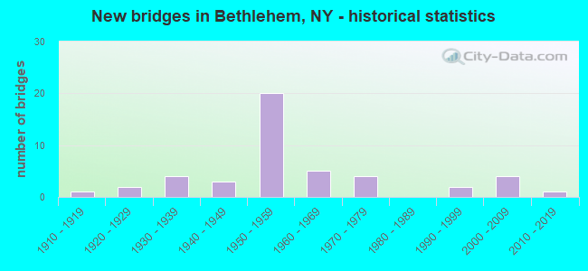
- New bridges - historical statistics
- 11910-1919
- 21920-1929
- 41930-1939
- 31940-1949
- 201950-1959
- 51960-1969
- 41970-1979
- 21990-1999
- 42000-2009
- 12010-2019
FCC Registered Antenna Towers:
50 (See the full list of FCC Registered Antenna Towers in Bethlehem)FCC Registered Commercial Land Mobile Towers:
1- Lat: 42.576194 Lon: -73.786500, Call Sign: KLZ891,
Assigned Frequencies: 26.4700 MHz, Grant Date: 08/04/2000, Expiration Date: 06/01/2006, Cancellation Date: 01/14/2004, Registrant: Schwartz, Woods & Miller, 1350 Connecticut Ave., Nw, Suite 300, Washington, DC 20036-1717, Phone: (202) 833-1700, Fax: (202) 833-2351, Email:
FCC Registered Private Land Mobile Towers:
1- Cr Hump Ld Trk In Selkirk Yard (Lat: 42.555917 Lon: -73.840111), Type: Mast, Structure height: 3 m, Call Sign: WPIK289,
Assigned Frequencies: 911.500 MHz, 918.500 MHz, Grant Date: 07/29/2015, Expiration Date: 09/21/2025, Certifier: Rae A Greene, Registrant: Csx Transportation, 6735 Southpoint Dr. S, 4th Flr J958, Jacksonville, FL 32216, Phone: (904) 332-5925, Fax: (904) 332-6013, Email:
FCC Registered Broadcast Land Mobile Towers:
3- Rt 9 W 2 Mi S Of Albany City Line (Lat: 42.617861 Lon: -73.780389), Call Sign: WCY614,
Assigned Frequencies: 456.125 MHz, 456.200 MHz, Grant Date: 06/24/2022, Expiration Date: 08/14/2032, Certifier: Chris Kelly, Registrant: Utilities Technology Council, 2550 South Clark St., Suite 960, Arlington, VA 22202, Phone: (202) 833-6818, Fax: (202) 872-1331, Email:
- L1, Lat: 42.555361 Lon: -73.839556, Call Sign: KEI538,
Assigned Frequencies: 160.710 MHz, 160.740 MHz, Grant Date: 04/07/2022, Expiration Date: 06/10/2032, Certifier: Rae A Greene, Registrant: Csx Transportation Inc, 6735 Southpoint Dr S, Suite 400, Jacksonville, FL 32216, Phone: (904) 279-6938, Fax: (904) 332-6013, Email:
- L7, Lat: 42.555139 Lon: -73.839917, Call Sign: WQAT666,
Assigned Frequencies: 452.950 MHz, 457.950 MHz, 457.862 MHz, Grant Date: 06/04/2014, Expiration Date: 08/04/2024, Certifier: Marc Dwyer, Registrant: Csx Transportation Inc, 6735 Southpoint Dr S, 4th Flr, Jacksonville, FL 32216, Phone: (904) 332-5925, Fax: (904) 332-6013, Email:
FCC Registered Microwave Towers:
6- BETHLEHEM, 501 Old Quarry Rd (Lat: 42.555639 Lon: -73.868556), Type: Tower, Structure height: 76.8 m, Overall height: 77.7 m, Call Sign: WMQ548,
Assigned Frequencies: 6756.25 MHz, Grant Date: 03/21/2011, Expiration Date: 02/01/2021, Cancellation Date: 04/18/2012, Certifier: Carol L Tacker, Registrant: At&t Mobility LLC, 5601 Legacy Drive Ms A-3, Plano, TX 75024, Phone: (469) 229-7471, Fax: (469) 229-7297, Email:
- STATION, Route 32 Overhead Bridge (Lat: 42.580056 Lon: -73.871778), Structure height: 13.4 m, Overall height: 13.7 m, Call Sign: WNTR353,
Assigned Frequencies: 23075.0 MHz, Grant Date: 03/02/1999, Expiration Date: 03/31/2008, Cancellation Date: 05/07/2007, Certifier: Rae A Greene, Registrant: Csx Transportation Inc., 6735 Southpoint Drive South, Jacksonville, FL 32216, Phone: (904) 332-5965, Fax: (904) 332-5963, Email:
- SELKIRK, Off Rt 102 Near Albany Filtr Plant (Lat: 42.552194 Lon: -73.866972), Type: Tower, Structure height: 54.9 m, Overall height: 59.1 m, Call Sign: WQOK854,
Assigned Frequencies: 10755.0 MHz, Grant Date: 11/01/2011, Expiration Date: 11/01/2021, Cancellation Date: 03/19/2014, Certifier: Pamelia Y Hoof, Registrant: Verizon Wireless, 1120 Sanctuary Pkwy, #150 Gasa5reg, Alpharetta, GA 30009-7630, Phone: (770) 797-1070, Fax: (770) 797-1036, Email:
- NY125 BETHLH, Cty Rt 102 (Lat: 42.555639 Lon: -73.868556), Type: Gtower, Structure height: 76.8 m, Overall height: 77.7 m, Call Sign: WREJ317, Licensee ID: L02205791,
Assigned Frequencies: 11565.0 MHz, 11645.0 MHz, 11565.0 MHz, 11645.0 MHz, 11565.0 MHz, 11645.0 MHz, 11565.0 MHz, 11645.0 MHz, 11565.0 MHz, 11645.0 MHz... (+19 more), Grant Date: 10/11/2019, Expiration Date: 10/11/2029, Certifier: Matt Guzzo, Registrant: Hudson Valley Wireless, 34 Russell Rd, Albany, NY 12205, Phone: (518) 458-7006, Email:
- ALALB00122A, Off Rt 102 Near Albany Filtr Plant (Lat: 42.552194 Lon: -73.866972), Type: Ltower, Structure height: 54.9 m, Overall height: 59.1 m, Call Sign: WRXY668,
Assigned Frequencies: 11265.0 MHz, 11265.0 MHz, 11265.0 MHz, 11265.0 MHz, 11265.0 MHz, 11265.0 MHz, 11265.0 MHz, 11265.0 MHz, 11265.0 MHz, 11265.0 MHz, 11265.0 MHz, 11265.0 MHz, Grant Date: 07/11/2023, Expiration Date: 07/11/2033, Certifier: Alison A Minea, Registrant: Dish Wireless L.L.C., 9601 S Meridan Blvd, Englewood, CO 80112, Phone: (202) 463-3709, Email:
- GLENMONT, Rt 9 W (Lat: 42.625056 Lon: -73.786778), Overall height: 55.8 m, Call Sign: WCU390,
Assigned Frequencies: 5974.85 MHz, 5945.20 MHz, 6034.15 MHz, 6063.80 MHz, 6093.45 MHz, 6152.75 MHz, Grant Date: 03/13/2001, Expiration Date: 02/01/2011, Cancellation Date: 12/13/2010, Certifier: Dennis W Guard Jr., Registrant: Mcimetro Access Transmission Services LLC, 2400 North Glenville Drive, 71216/107, Richardson, TX 75082, Phone: (972) 729-6406, Fax: (972) 729-2690, Email:
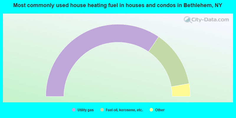
- 69.1%Utility gas
- 25.3%Fuel oil, kerosene, etc.
- 4.0%Electricity
- 1.0%Bottled, tank, or LP gas
- 0.6%Wood
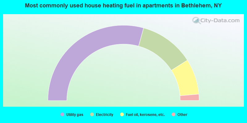
- 58.6%Utility gas
- 23.4%Electricity
- 15.3%Fuel oil, kerosene, etc.
- 1.4%Bottled, tank, or LP gas
- 1.0%Other fuel
- 0.3%Wood
Bethlehem compared to New York state average:
- Unemployed percentage significantly below state average.
- Black race population percentage significantly below state average.
- Hispanic race population percentage significantly below state average.
- Foreign-born population percentage significantly below state average.
- Renting percentage below state average.
- Length of stay since moving in significantly above state average.
- Number of rooms per house significantly below state average.
- House age significantly below state average.
- Percentage of population with a bachelor's degree or higher above state average.
Bethlehem on our top lists:
- #15 on the list of "Top 101 cities with largest percentage of males in occupations: lawyers (population 5,000+)"
- #21 on the list of "Top 101 cities with largest percentage of females in occupations: lawyers (population 5,000+)"
- #25 on the list of "Top 101 cities with largest percentage of males in occupations: social scientists and related workers (population 5,000+)"
- #31 on the list of "Top 101 cities with largest percentage of males in occupations: physicians and surgeons (population 5,000+)"
- #41 on the list of "Top 101 cities with largest percentage of males in industries: health care (population 5,000+)"
- #42 on the list of "Top 101 cities with largest percentage of females in industries: religious, grantmaking, civic, professional, and similar organizations (population 5,000+)"
- #49 on the list of "Top 101 cities with largest percentage of females in occupations: postsecondary teachers (population 5,000+)"
- #50 on the list of "Top 101 cities with largest percentage of females in occupations: rail and water transportation workers (population 5,000+)"
- #52 on the list of "Top 101 cities with largest percentage of males in industries: rail transportation (population 5,000+)"
- #69 on the list of "Top 101 cities with largest percentage of females in industries: rail transportation (population 5,000+)"
- #82 on the list of "Top 101 cities with largest percentage of males in industries: social assistance (population 5,000+)"
- #100 on the list of "Top 101 cities with largest percentage of females in industries: public administration (population 5,000+)"
- #28 on the list of "Top 101 counties with the highest number of infant deaths per 1000 residents 2007-2013 (pop. 50,000+)"
- #36 on the list of "Top 101 counties with the largest increase in the number of infant deaths per 1000 residents 2000-2006 to 2007-2013 (pop. 50,000+)"
- #59 on the list of "Top 101 counties with the lowest number of births per 1000 residents 2007-2013"
- #75 on the list of "Top 101 counties with the most Orthodox congregations"
- #78 on the list of "Top 101 counties with the largest decrease in the number of deaths per 1000 residents 2000-2006 to 2007-2013 (pop. 50,000+)"

|
Total of 10 patent applications in 2008-2024.