Beulah, Alabama
Submit your own pictures of this place and show them to the world
- OSM Map
- General Map
- Google Map
- MSN Map

| Males: 3,054 | |
| Females: 3,133 |
| Median resident age: | 33.7 years |
| Alabama median age: | 35.8 years |
Zip code: 36854
| Beulah: | $74,342 |
| AL: | $59,674 |
Estimated per capita income in 2022: $32,739 (it was $16,903 in 2000)
Beulah CCD income, earnings, and wages data
Estimated median house or condo value in 2022: $211,737 (it was $68,600 in 2000)
| Beulah: | $211,737 |
| AL: | $200,900 |
Mean prices in 2022: all housing units: $282,920; detached houses: $328,621; townhouses or other attached units: $253,364; in 2-unit structures: $360,650; in 3-to-4-unit structures: $212,994; in 5-or-more-unit structures: $198,986; mobile homes: $70,408; occupied boats, rvs, vans, etc.: $237,133
Detailed information about poverty and poor residents in Beulah, AL


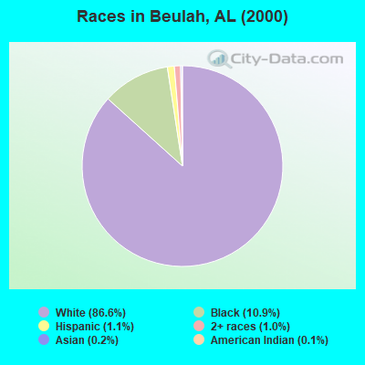
- 4,73186.6%White alone
- 59510.9%Black alone
- 611.1%Hispanic
- 561.0%Two or more races
- 90.2%Asian alone
- 80.1%American Indian alone
- 30.05%Native Hawaiian and Other
Pacific Islander alone - 20.04%Other race alone
 Recent articles from our blog. Our writers, many of them Ph.D. graduates or candidates, create easy-to-read articles on a wide variety of topics.
Current Local Time: CST time zone
Land area: 70.3 square miles.
Population density: 88 people per square mile (very low).

| Beulah CCD: | 0.6% ($399) |
| Alabama: | 0.4% ($289) |
Nearest city with pop. 50,000+: Columbus, GA  (20.5 miles , pop. 185,781).
Nearest city with pop. 200,000+: Montgomery, AL (66.6 miles , pop. 201,568).
Nearest city with pop. 1,000,000+: Houston, TX (634.8 miles , pop. 1,953,631).
Nearest cities:
), ), ), ), )Latitude: 32.69 N, Longitude: 85.20 W
Area code commonly used in this area: 334

| Here: | 2.4% |
| Alabama: | 2.6% |
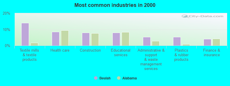
- Textile mills & textile products (14.0%)
- Health care (8.5%)
- Construction (8.0%)
- Educational services (7.9%)
- Administrative & support & waste management services (5.3%)
- Plastics & rubber products (5.2%)
- Finance & insurance (4.0%)
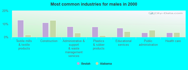
- Textile mills & textile products (13.0%)
- Construction (11.0%)
- Administrative & support & waste management services (7.9%)
- Plastics & rubber products (7.8%)
- Educational services (6.8%)
- Public administration (3.4%)
- Health care (3.3%)
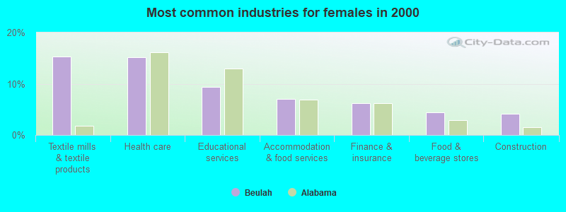
- Textile mills & textile products (15.3%)
- Health care (15.1%)
- Educational services (9.4%)
- Accommodation & food services (7.0%)
- Finance & insurance (6.3%)
- Food & beverage stores (4.4%)
- Construction (4.2%)
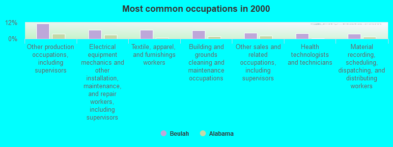
- Other production occupations, including supervisors (11.4%)
- Electrical equipment mechanics and other installation, maintenance, and repair workers, including supervisors (6.7%)
- Textile, apparel, and furnishings workers (6.5%)
- Building and grounds cleaning and maintenance occupations (6.3%)
- Other sales and related occupations, including supervisors (4.4%)
- Health technologists and technicians (4.0%)
- Material recording, scheduling, dispatching, and distributing workers (3.8%)
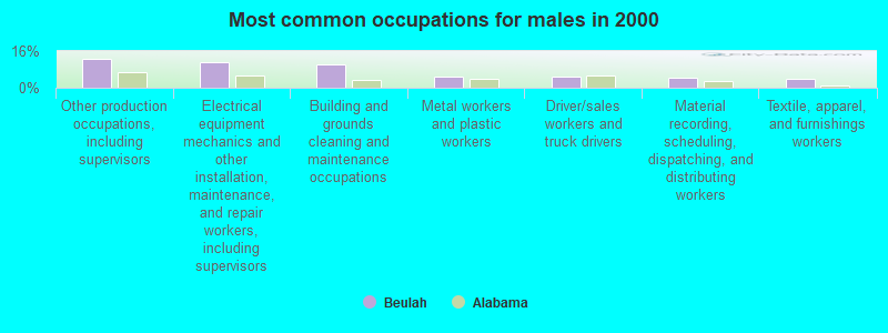
- Other production occupations, including supervisors (12.6%)
- Electrical equipment mechanics and other installation, maintenance, and repair workers, including supervisors (11.1%)
- Building and grounds cleaning and maintenance occupations (10.2%)
- Metal workers and plastic workers (5.0%)
- Driver/sales workers and truck drivers (4.7%)
- Material recording, scheduling, dispatching, and distributing workers (4.2%)
- Textile, apparel, and furnishings workers (3.7%)
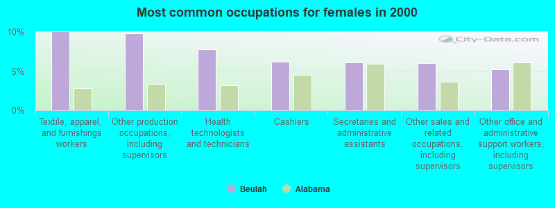
- Textile, apparel, and furnishings workers (10.0%)
- Other production occupations, including supervisors (9.9%)
- Health technologists and technicians (7.8%)
- Cashiers (6.2%)
- Secretaries and administrative assistants (6.1%)
- Other sales and related occupations, including supervisors (6.0%)
- Other office and administrative support workers, including supervisors (5.2%)
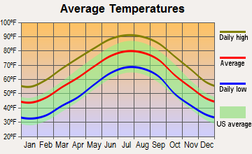
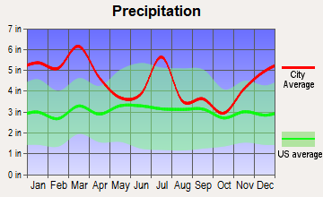
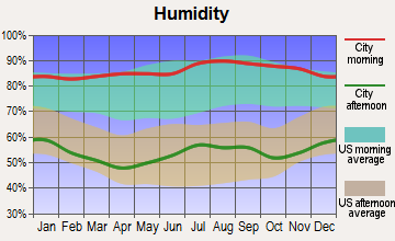
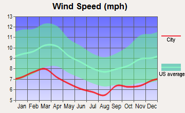
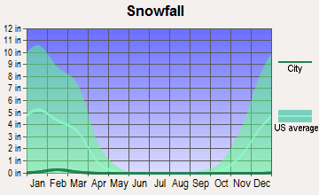
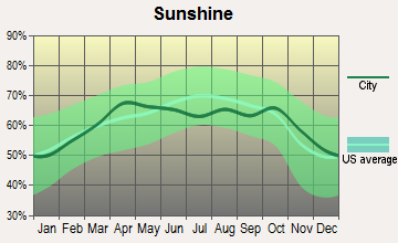
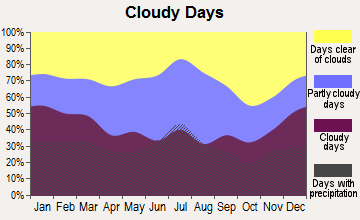
Average climate in Beulah, Alabama
Based on data reported by over 4,000 weather stations
(lower is better)
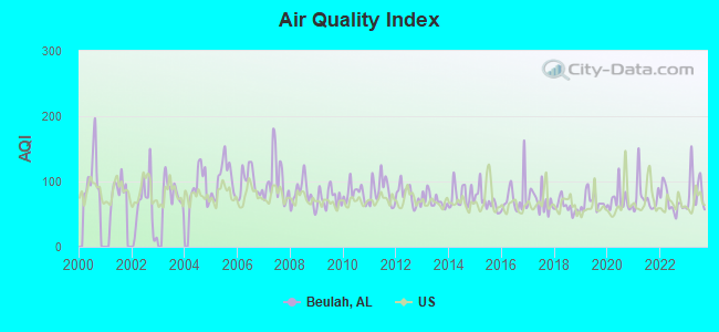
Air Quality Index (AQI) level in 2023 was 86.5. This is about average.
| City: | 86.5 |
| U.S.: | 72.6 |
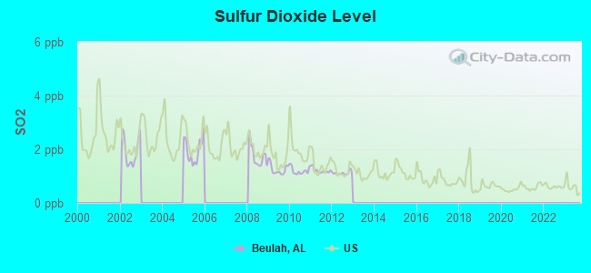
Sulfur Dioxide (SO2) [ppb] level in 2012 was 1.11. This is better than average. Closest monitor was 18.9 miles away from the city center.
| City: | 1.11 |
| U.S.: | 1.51 |
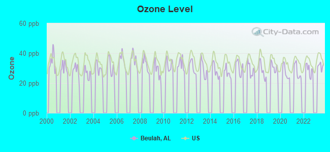
Ozone [ppb] level in 2023 was 31.5. This is about average. Closest monitor was 16.7 miles away from the city center.
| City: | 31.5 |
| U.S.: | 33.3 |
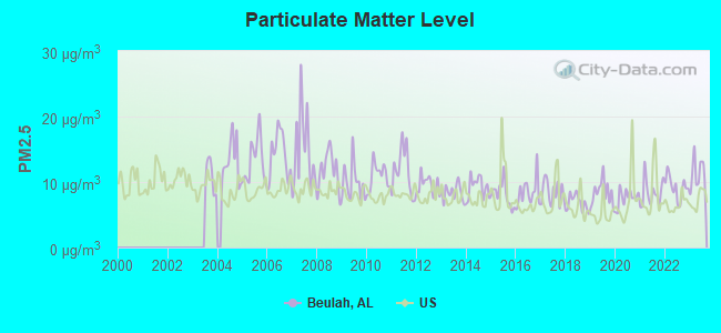
Particulate Matter (PM2.5) [µg/m3] level in 2023 was 11.3. This is worse than average. Closest monitor was 18.9 miles away from the city center.
| City: | 11.3 |
| U.S.: | 8.1 |
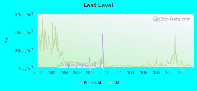
Lead (Pb) [µg/m3] level in 2008 was 0.00433. This is significantly better than average. Closest monitor was 19.1 miles away from the city center.
| City: | 0.00433 |
| U.S.: | 0.00931 |
Tornado activity:
Beulah-area historical tornado activity is slightly below Alabama state average. It is 41% greater than the overall U.S. average.
On 3/19/1970, a category F3 (max. wind speeds 158-206 mph) tornado 9.9 miles away from the Beulah place center killed 2 people and injured 14 people and caused between $50,000 and $500,000 in damages.
On 12/5/1954, a category F3 tornado 12.6 miles away from the place center injured 7 people and caused between $50,000 and $500,000 in damages.
Earthquake activity:
Beulah-area historical earthquake activity is significantly above Alabama state average. It is 46% greater than the overall U.S. average.On 4/29/2003 at 08:59:39, a magnitude 4.9 (4.4 MB, 4.6 MW, 4.9 LG, Class: Light, Intensity: IV - V) earthquake occurred 127.4 miles away from the city center
On 1/18/1999 at 07:00:53, a magnitude 4.8 (4.8 MB, 4.0 LG, Depth: 0.6 mi) earthquake occurred 128.9 miles away from Beulah center
On 10/24/1997 at 08:35:17, a magnitude 4.9 (4.8 MB, 4.2 MS, 4.9 LG, Depth: 6.2 mi) earthquake occurred 162.6 miles away from the city center
On 8/2/1974 at 08:52:09, a magnitude 4.9 (4.3 MB, 4.9 LG) earthquake occurred 177.1 miles away from Beulah center
On 4/29/2003 at 08:59:39, a magnitude 4.6 (4.6 MW, Depth: 12.3 mi) earthquake occurred 127.4 miles away from the city center
On 6/24/1975 at 11:11:36, a magnitude 4.5 (4.5 MB) earthquake occurred 168.5 miles away from the city center
Magnitude types: regional Lg-wave magnitude (LG), body-wave magnitude (MB), surface-wave magnitude (MS), moment magnitude (MW)
Natural disasters:
The number of natural disasters in Lee County (17) is near the US average (15).Major Disasters (Presidential) Declared: 9
Emergencies Declared: 6
Causes of natural disasters: Storms: 8, Tornadoes: 8, Floods: 6, Hurricanes: 5, Winds: 4, Drought: 1, Snowfall: 1, Winter Storm: 1, Other: 1 (Note: some incidents may be assigned to more than one category).
Hospitals and medical centers near Beulah:
- CARESOUTH HOMECARE PROFESSIONALS (Home Health Center, about 10 miles away; VALLEY, AL)
- GEORGE H. LANIER MEMORIAL HOSPITAL Acute Care Hospitals (about 10 miles away; VALLEY, AL)
- GEORGE H LANIER MEMORIAL NURSING HOME (Nursing Home, about 10 miles away; VALLEY, AL)
- LANIER HOME HEALTH SERVICES (Home Health Center, about 10 miles away; VALLEY, AL)
- ARBOR SPRINGS HEALTH AND REHAB CENTER, LTD (Nursing Home, about 12 miles away; OPELIKA, AL)
- GOLDEN LIVING CENTER - LANETT (Nursing Home, about 12 miles away; LANETT, AL)
- EAST ALABAMA MEDICAL CENTER AND SNF Acute Care Hospitals (about 13 miles away; OPELIKA, AL)
Colleges/universities with over 2000 students nearest to Beulah:
- Auburn University (about 18 miles; Auburn University, AL; Full-time enrollment: 22,741)
- Columbus Technical College (about 19 miles; Columbus, GA; FT enrollment: 3,241)
- Columbus State University (about 20 miles; Columbus, GA; FT enrollment: 6,876)
- Tuskegee University (about 35 miles; Tuskegee, AL; FT enrollment: 2,810)
- Southern Union State Community College (about 38 miles; Wadley, AL; FT enrollment: 4,120)
- Auburn University at Montgomery (about 61 miles; Montgomery, AL; FT enrollment: 4,092)
- University of West Georgia (about 62 miles; Carrollton, GA; FT enrollment: 10,358)
Points of interest:
Notable locations in Beulah: Lee Chambers Fire Department Station 2 (A), Lee Chambers Fire Department Station 5 (B), Lee Chambers Fire Department Station 4 (C), Lee Chambers Fire Department Station 1 (D). Display/hide their locations on the map
Churches in Beulah include: Mount Zion Church (A), New Hope Church (B), Pitts Chapel (C), Pleasant Hill Church (D), Ridge Grove Church (E), Ridge Road Church (F), Beulah United Methodist Church (G), Wallace Chapel Church (H), Salem United Methodist Church (I). Display/hide their locations on the map
Cemeteries: Shady Grove Cemetery (1), Salem Cemetery (2), Pitts Chapel Cemetery (3), Mountain Springs Cemeteries (4), Beulah Cemetery (5), Hephzibah Cemetery (6), Holt Cemetery (7). Display/hide their locations on the map
Reservoir: Osment Pond (A). Display/hide its location on the map
Creeks: Little Halawaka Creek (A), Halawakee Creek (B). Display/hide their locations on the map
Park in Beulah: Spring Villa Camping and Recreation Area (1). Display/hide its location on the map
| This place: | 2.7 people |
| Alabama: | 2.5 people |
| This place: | 73.4% |
| Whole state: | 67.8% |
| This place: | 6.3% |
| Whole state: | 4.7% |
Likely homosexual households (counted as self-reported same-sex unmarried-partner households)
- Lesbian couples: 0.4% of all households
- Gay men: 0.2% of all households
| This place: | 5.8% |
| Whole state: | 16.1% |
| This place: | 3.3% |
| Whole state: | 7.3% |
For population 15 years and over in Beulah:
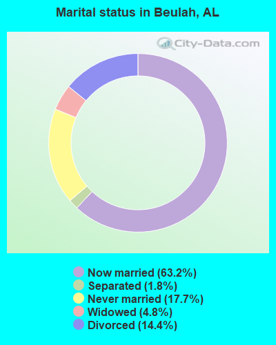
- Never married: 17.7%
- Now married: 63.2%
- Separated: 1.8%
- Widowed: 4.8%
- Divorced: 14.4%
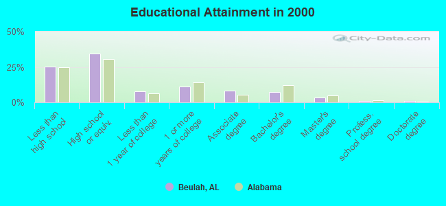
For population 25 years and over in Beulah:
- High school or higher: 74.5%
- Bachelor's degree or higher: 12.7%
- Graduate or professional degree: 5.5%
- Unemployed: 3.7%
- Mean travel time to work (commute): 27.4 minutes
| Here: | 12.9 |
| Alabama average: | 13.2 |
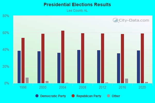
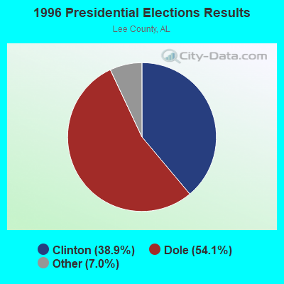
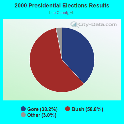
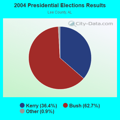
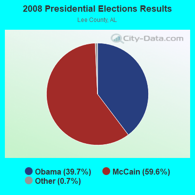
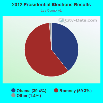

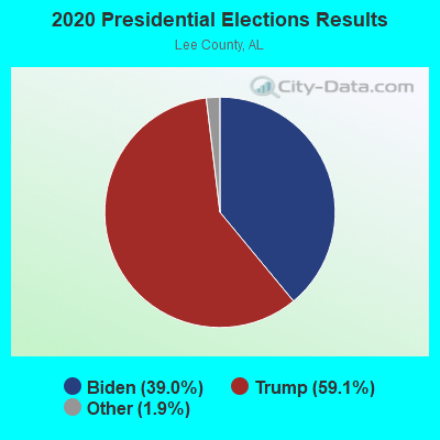
Graphs represent county-level data. Detailed 2008 Election Results
Religion statistics for Beulah, AL (based on Lee County data)
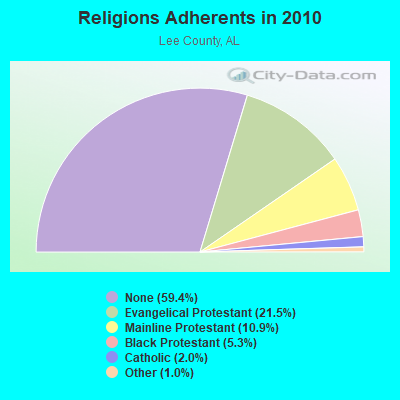
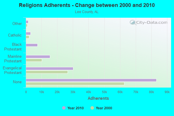
| Religion | Adherents | Congregations |
|---|---|---|
| Evangelical Protestant | 30,090 | 93 |
| Mainline Protestant | 15,250 | 30 |
| Black Protestant | 7,368 | 41 |
| Catholic | 2,872 | 2 |
| Other | 1,416 | 9 |
| Orthodox | - | - |
| None | 83,251 | - |
Food Environment Statistics:
| Lee County: | 1.07 / 10,000 pop. |
| Alabama: | 1.89 / 10,000 pop. |
| This county: | 0.15 / 10,000 pop. |
| Alabama: | 0.20 / 10,000 pop. |
| This county: | 0.54 / 10,000 pop. |
| State: | 0.65 / 10,000 pop. |
| Lee County: | 5.29 / 10,000 pop. |
| Alabama: | 6.32 / 10,000 pop. |
| Here: | 7.05 / 10,000 pop. |
| Alabama: | 5.75 / 10,000 pop. |
| This county: | 9.4% |
| State: | 11.8% |
| This county: | 30.2% |
| State: | 31.7% |
| Here: | 9.2% |
| Alabama: | 13.5% |
9.27% of this county's 2021 resident taxpayers lived in other counties in 2020 ($62,614 average adjusted gross income)
| Here: | 9.27% |
| Alabama average: | 6.87% |
0.04% of residents moved from foreign countries ($289 average AGI)
Lee County: 0.04% Alabama average: 0.02%
Top counties from which taxpayers relocated into this county between 2020 and 2021:
| from Russell County, AL | |
| from Muscogee County, GA | |
| from Chambers County, AL |
8.53% of this county's 2020 resident taxpayers moved to other counties in 2021 ($56,480 average adjusted gross income)
| Here: | 8.53% |
| Alabama average: | 6.41% |
0.04% of residents moved to foreign countries ($244 average AGI)
Lee County: 0.04% Alabama average: 0.02%
Top counties to which taxpayers relocated from this county between 2020 and 2021:
| to Russell County, AL | |
| to Muscogee County, GA | |
| to Chambers County, AL |
Strongest AM radio stations in Beulah:
- WDAK (540 AM; 5 kW; COLUMBUS, GA; Owner: CLEAR CHANNEL BROADCASTING LICENSES, INC.)
- WTLM (1520 AM; daytime; 5 kW; OPELIKA, AL; Owner: QANTUM OF AUBURN LICENSE COMPANY, LLC)
- WRCG (1420 AM; 5 kW; COLUMBUS, GA; Owner: ABG GEORGIA, LLC)
- WGSE (720 AM; daytime; 8 kW; HOGANSVILLE, GA; Owner: CITICASTERS LICENSES, L.P.)
- WGST (640 AM; 50 kW; ATLANTA, GA; Owner: CITICASTERS LICENSES, L.P.)
- WMLF (1270 AM; 5 kW; COLUMBUS, GA; Owner: CLEAR CHANNEL BROADCASTING LICENSES, INC.)
- WKNG (1060 AM; daytime; 50 kW; TALLAPOOSA, GA; Owner: WKNG, INC.)
- WNSI (810 AM; 50 kW; JACKSONVILLE, AL; Owner: UNITED BROADCASTING NETWORK, INC.)
- WMAC (940 AM; 50 kW; MACON, GA; Owner: CUMULUS LICENSING CORP.)
- WSB (750 AM; 50 kW; ATLANTA, GA; Owner: CXR HOLDINGS, INC.)
- WCNN (680 AM; 50 kW; NORTH ATLANTA, GA; Owner: DICKEY BROADCASTING COMPANY)
- WGUN (1010 AM; 50 kW; ATLANTA, GA; Owner: WGUN, INC.)
- WMLB (1160 AM; 50 kW; EAST POINT, GA; Owner: ATLANTA AREA BROADCASTING, INC.)
Strongest FM radio stations in Beulah:
- WRLD-FM (95.3 FM; VALLEY, AL; Owner: ABG GEORGIA, LLC)
- WSTH-FM (106.1 FM; ALEXANDER CITY, AL; Owner: CLEAR CHANNEL BROADCASTING LICENSES, INC.)
- WMXA (96.7 FM; OPELIKA, AL; Owner: QANTUM OF AUBURN LICENSE COMPANY, LLC)
- WCGQ (107.3 FM; COLUMBUS, GA; Owner: ABG GEORGIA, LLC)
- WVFJ-FM (93.3 FM; MANCHESTER, GA; Owner: PROVIDENT BROADCASTING COMPANY)
- WYFK (89.5 FM; COLUMBUS, GA; Owner: BIBLE BROADCASTING NETWORK, INC.)
- WKKR (97.7 FM; AUBURN, AL; Owner: QANTUM OF AUBURN LICENSE COMPANY, LLC)
- WJSP-FM (88.1 FM; WARM SPRINGS, GA; Owner: GEORGIA PUBLIC TELECOMMUNICATIONS COMMISSION)
- WCJM-FM (100.9 FM; WEST POINT, GA; Owner: QANTUM OF AUBURN LICENSE COMPANY, LLC)
- WKZJ (95.7 FM; GREENVILLE, GA; Owner: DAVIS B/CASTING OF COLUMBUS, INC)
- W212AP (90.3 FM; NOTASULGA, ETC., AL; Owner: FAMILY STATIONS, INC.)
- WLWI-FM (92.3 FM; MONTGOMERY, AL; Owner: CUMULUS LICENSING CORP.)
- WGSY (100.1 FM; PHENIX CITY, AL; Owner: CLEAR CHANNEL BROADCASTING LICENSES, INC.)
- WBFA (101.3 FM; SMITHS, AL; Owner: CLEAR CHANNEL BROADCASTING LICENSES, INC.)
- WQNR (99.9 FM; TALLASSEE, AL; Owner: TIGER COMMUNICATIONS, INC.)
- WFXE (104.9 FM; COLUMBUS, GA; Owner: DAVIS BROADCASTING)
- WEBT (91.5 FM; LANGDALE, AL; Owner: LANGDALE ED. BROADCASTING FOUNDATION)
- WFRC (90.5 FM; COLUMBUS, GA; Owner: FAMILY STATIONS, INC.)
- WAGH (98.3 FM; FORT MITCHELL, AL; Owner: CLEAR CHANNEL BROADCASTING LICENSES, INC.)
- WEGL (91.1 FM; AUBURN, AL; Owner: BOARD OF TRUSTEES AUBURN UNIVERSITY)
TV broadcast stations around Beulah:
- WSWS-TV (Channel 66; OPELIKA, AL; Owner: PAPPAS TELECASTING OF OPELIKA)
- WTVM (Channel 9; COLUMBUS, GA; Owner: RAYCOM AMERICA, INC.)
- WLTZ (Channel 38; COLUMBUS, GA; Owner: LEWIS BROADCASTING CORPORATION)
- WCGT-LP (Channel 16; COLUMBUS, GA; Owner: COLUMBUS TELEVISION, INC.)
- WRBL (Channel 3; COLUMBUS, GA; Owner: MEDIA GENERAL BROADCASTING OF SO. CAROLINA HOLDINGS, INC.)
- WXTX (Channel 54; COLUMBUS, GA; Owner: FISHER BROADCASTING - GEORGIA, L.L.C.)
- WJSP-TV (Channel 28; COLUMBUS, GA; Owner: GEORGIA PUBLIC TELECOMMUNICATIONS COMMISSION)
- W55CR (Channel 55; ATLANTA, GA; Owner: WORD OF GOD FELLOWSHIP, INC.)
- W18CD (Channel 18; OPELIKA, AL; Owner: TRINITY BROADCASTING NETWORK)
- W06BH (Channel 6; PHENIX CITY, ETC., AL; Owner: GREENE COMMUNICATIONS, INC.)
- National Bridge Inventory (NBI) Statistics
- 16Number of bridges
- 240ft / 73.1mTotal length
- $19,490,000Total costs
- 12,005Total average daily traffic
- 748Total average daily truck traffic
- 18,011Total future (year 2040) average daily traffic
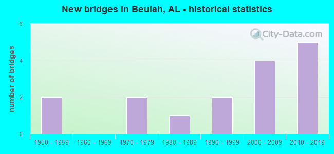
- New bridges - historical statistics
- 21950-1959
- 21970-1979
- 11980-1989
- 21990-1999
- 42000-2009
- 52010-2019
FCC Registered Antenna Towers:
11 (See the full list of FCC Registered Antenna Towers in Beulah)FCC Registered Broadcast Land Mobile Towers:
2- Lat: 32.729306 Lon: -85.224944, Call Sign: KNFL506,
Assigned Frequencies: 153.845 MHz, 155.145 MHz, Grant Date: 01/27/2022, Expiration Date: 04/22/2032, Registrant: Lee County Emergency Management Agency, 908 Avenue B, Opelika, AL 36801, Phone: (334) 749-8161, Email:
- Int Cty 68 & 62 (Lat: 32.711250 Lon: -85.177444), Call Sign: KNFL507,
Assigned Frequencies: 153.845 MHz, 155.145 MHz, Grant Date: 01/27/2022, Expiration Date: 04/22/2032, Registrant: Lee County Emergency Management Agency, 908 Avenue B, Opelika, AL 36801, Phone: (334) 749-8161, Email:
FCC Registered Microwave Towers:
1- LAKE HARDING, Lee County Road 364 (Lat: 32.694861 Lon: -85.149667), Type: Gtower, Structure height: 71.6 m, Overall height: 76.8 m, Call Sign: WQQN945,
Assigned Frequencies: 6404.79 MHz, Grant Date: 01/04/2023, Expiration Date: 02/05/2033, Certifier: Gregory M Romano, Registrant: Verizon, 5055 Northpointe Pkwy, Alpharetta, GA 30022, Phone: (770) 797-1070, Email:
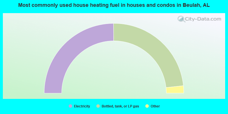
- 49.8%Electricity
- 46.8%Bottled, tank, or LP gas
- 2.2%Wood
- 1.2%Utility gas
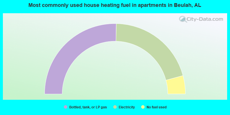
- 50.6%Bottled, tank, or LP gas
- 41.0%Electricity
- 8.4%No fuel used
Beulah compared to Alabama state average:
- Unemployed percentage significantly below state average.
- Black race population percentage below state average.
- Hispanic race population percentage significantly below state average.
- Median age significantly below state average.
- Foreign-born population percentage significantly below state average.
- Length of stay since moving in significantly above state average.
- Number of rooms per house significantly below state average.
- House age significantly below state average.
- Number of college students below state average.
- Percentage of population with a bachelor's degree or higher below state average.
Beulah on our top lists:
- #1 on the list of "Top 101 cities with largest percentage of females in industries: office supplies and stationery stores (population 5,000+)"
- #3 on the list of "Top 101 cities with largest percentage of males in occupations: printing workers (population 5,000+)"
- #6 on the list of "Top 101 cities with largest percentage of males in occupations: electrical equipment mechanics and other installation, maintenance, and repair occupations including supervisors (population 5,000+)"
- #7 on the list of "Top 101 cities with largest percentage of females in occupations: other production occupations including supervisors (population 5,000+)"
- #7 on the list of "Top 101 cities with largest percentage of males in industries: plastics and rubber products (population 5,000+)"
- #9 on the list of "Top 101 cities with largest percentage of females in occupations: textile, apparel, and furnishings workers (population 5,000+)"
- #9 on the list of "Top 101 cities with largest percentage of females in industries: textile mills and textile products (population 5,000+)"
- #10 on the list of "Top 101 cities with largest percentage of males in industries: textile mills and textile products (population 5,000+)"
- #11 on the list of "Top 101 cities with largest percentage of males in occupations: other production occupations including supervisors (population 5,000+)"
- #15 on the list of "Top 101 cities with largest percentage of females in occupations: communications equipment operators (population 5,000+)"
- #20 on the list of "Top 101 cities with largest percentage of males in industries: metals and minerals, except petroleum, merchant wholesalers (population 5,000+)"
- #24 on the list of "Top 101 cities with largest percentage of females in industries: motor vehicle and parts dealers (population 5,000+)"
- #33 on the list of "Top 101 cities with largest percentage of females in industries: paper (population 5,000+)"
- #43 on the list of "Top 101 cities with largest percentage of females in industries: building material and garden equipment and supplies dealers (population 5,000+)"
- #43 on the list of "Top 101 cities with largest percentage of females in industries: plastics and rubber products (population 5,000+)"
- #48 on the list of "Top 101 cities with the largest percentage of mobile homes (2,000+ housing units)"
- #50 on the list of "Top 101 cities with largest percentage of females in industries: book stores and news dealers (population 5,000+)"
- #51 on the list of "Top 101 cities with largest percentage of females in industries: apparel, fabrics, and notions merchant wholesalers (population 5,000+)"
- #61 on the list of "Top 101 cities with largest percentage of females in industries: miscellaneous manufacturing (population 5,000+)"
- #75 on the list of "Top 101 cities with largest percentage of males in industries: paper (population 5,000+)"
- #5 (36854) on the list of "Top 101 zip codes with the lowest 2012 average reported profit/loss from business (pop 5,000+)"
- #58 on the list of "Top 101 counties with the largest number of people moving in compared to moving out (pop. 50,000+)"
- #80 on the list of "Top 101 counties with the most Black Protestant congregations"
- #82 on the list of "Top 101 counties with the highest percentage of residents relocating from other counties between 2010 and 2011 (pop. 50,000+)"
- #88 on the list of "Top 101 counties with the smallest number of people without health insurance coverage in 2000 (pop. 50,000+)"