Langdale, Alabama
Submit your own pictures of this place and show them to the world
- OSM Map
- General Map
- Google Map
- MSN Map

| Males: 6,354 | |
| Females: 7,174 |
| Median resident age: | 37.3 years |
| Alabama median age: | 35.8 years |
Zip code: 36854
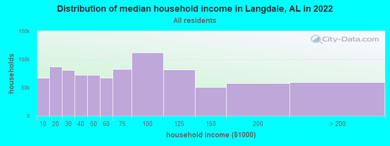
| Langdale: | $49,897 |
| AL: | $59,674 |
Estimated per capita income in 2022: $27,628 (it was $15,297 in 2000)
Langdale CCD income, earnings, and wages data
Estimated median house or condo value in 2022: $124,214 (it was $53,800 in 2000)
| Langdale: | $124,214 |
| AL: | $200,900 |
Detailed information about poverty and poor residents in Langdale, AL


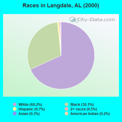
- 9,71568.2%White alone
- 4,29730.1%Black alone
- 990.7%Hispanic
- 730.5%Two or more races
- 410.3%Asian alone
- 230.2%American Indian alone
- 60.04%Other race alone
 Recent articles from our blog. Our writers, many of them Ph.D. graduates or candidates, create easy-to-read articles on a wide variety of topics.
Current Local Time: CST time zone
Land area: 71.5 square miles.
Population density: 189 people per square mile (very low).

| Langdale CCD: | 0.4% ($199) |
| Alabama: | 0.4% ($289) |
Nearest city with pop. 50,000+: Columbus, GA  (26.3 miles , pop. 185,781).
Nearest city with pop. 200,000+: Montgomery, AL (70.5 miles , pop. 201,568).
Nearest city with pop. 1,000,000+: Houston, TX (637.8 miles , pop. 1,953,631).
Nearest cities:
), ), ), ), Latitude: 32.81 N, Longitude: 85.19 W
Area code: 334

| Here: | 2.7% |
| Alabama: | 2.6% |
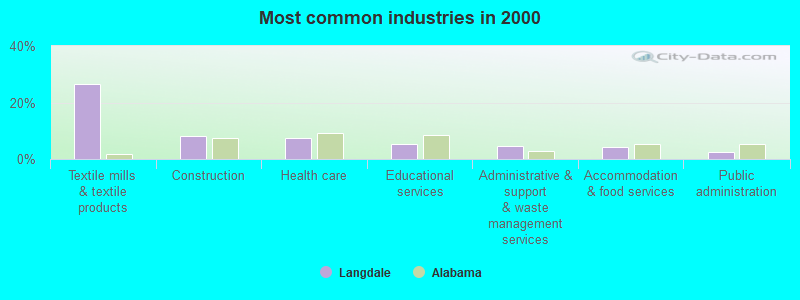
- Textile mills & textile products (26.6%)
- Construction (8.0%)
- Health care (7.5%)
- Educational services (5.4%)
- Administrative & support & waste management services (4.7%)
- Accommodation & food services (4.4%)
- Public administration (2.4%)
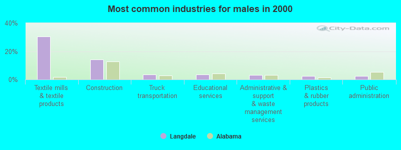
- Textile mills & textile products (30.4%)
- Construction (14.3%)
- Truck transportation (3.4%)
- Educational services (3.4%)
- Administrative & support & waste management services (3.3%)
- Plastics & rubber products (2.6%)
- Public administration (2.6%)
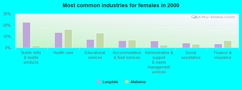
- Textile mills & textile products (22.7%)
- Health care (13.6%)
- Educational services (7.4%)
- Accommodation & food services (6.4%)
- Administrative & support & waste management services (6.2%)
- Social assistance (4.2%)
- Finance & insurance (3.4%)
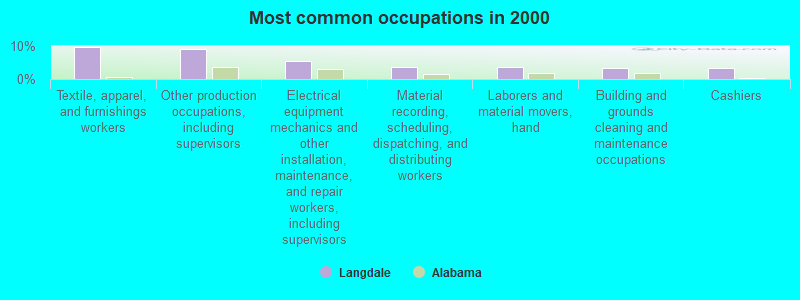
- Textile, apparel, and furnishings workers (9.7%)
- Other production occupations, including supervisors (9.1%)
- Electrical equipment mechanics and other installation, maintenance, and repair workers, including supervisors (5.4%)
- Material recording, scheduling, dispatching, and distributing workers (3.7%)
- Laborers and material movers, hand (3.7%)
- Building and grounds cleaning and maintenance occupations (3.4%)
- Cashiers (3.3%)
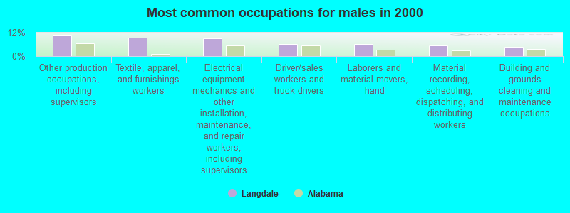
- Other production occupations, including supervisors (10.4%)
- Textile, apparel, and furnishings workers (9.4%)
- Electrical equipment mechanics and other installation, maintenance, and repair workers, including supervisors (9.2%)
- Driver/sales workers and truck drivers (6.2%)
- Laborers and material movers, hand (6.1%)
- Material recording, scheduling, dispatching, and distributing workers (5.4%)
- Building and grounds cleaning and maintenance occupations (4.6%)
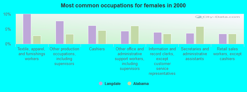
- Textile, apparel, and furnishings workers (10.0%)
- Other production occupations, including supervisors (7.7%)
- Cashiers (6.2%)
- Other office and administrative support workers, including supervisors (4.4%)
- Information and record clerks, except customer service representatives (3.9%)
- Secretaries and administrative assistants (3.6%)
- Retail sales workers, except cashiers (3.4%)
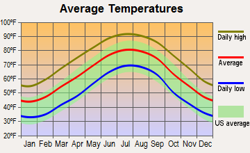
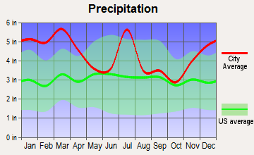
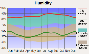
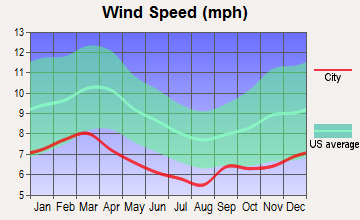
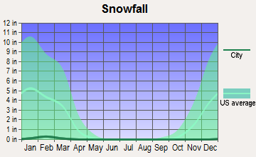
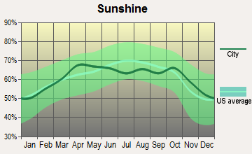
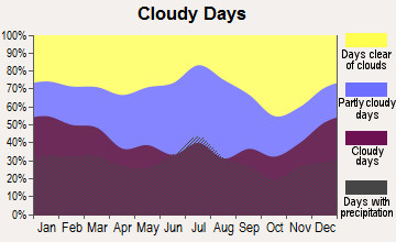
Average climate in Langdale, Alabama
Based on data reported by over 4,000 weather stations
(lower is better)
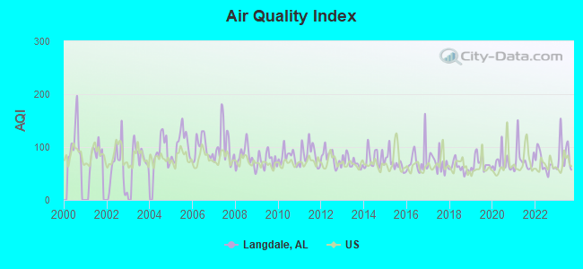
Air Quality Index (AQI) level in 2023 was 86.0. This is about average.
| City: | 86.0 |
| U.S.: | 72.6 |
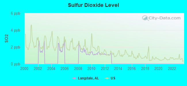
Sulfur Dioxide (SO2) [ppb] level in 2012 was 1.11. This is better than average. Closest monitor was 24.4 miles away from the city center.
| City: | 1.11 |
| U.S.: | 1.51 |
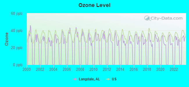
Ozone [ppb] level in 2023 was 31.5. This is about average. Closest monitor was 24.3 miles away from the city center.
| City: | 31.5 |
| U.S.: | 33.3 |
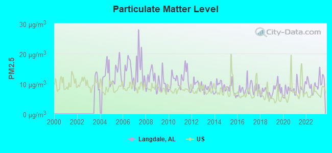
Particulate Matter (PM2.5) [µg/m3] level in 2023 was 11.2. This is worse than average. Closest monitor was 24.4 miles away from the city center.
| City: | 11.2 |
| U.S.: | 8.1 |
Tornado activity:
Langdale-area historical tornado activity is slightly below Alabama state average. It is 45% greater than the overall U.S. average.
On 3/19/1970, a category F3 (max. wind speeds 158-206 mph) tornado 1.7 miles away from the Langdale place center killed 2 people and injured 14 people and caused between $50,000 and $500,000 in damages.
On 12/5/1954, a category F3 tornado 15.9 miles away from the place center injured 7 people and caused between $50,000 and $500,000 in damages.
Earthquake activity:
Langdale-area historical earthquake activity is significantly above Alabama state average. It is 49% greater than the overall U.S. average.On 4/29/2003 at 08:59:39, a magnitude 4.9 (4.4 MB, 4.6 MW, 4.9 LG, Class: Light, Intensity: IV - V) earthquake occurred 119.4 miles away from Langdale center
On 1/18/1999 at 07:00:53, a magnitude 4.8 (4.8 MB, 4.0 LG, Depth: 0.6 mi) earthquake occurred 126.6 miles away from Langdale center
On 10/24/1997 at 08:35:17, a magnitude 4.9 (4.8 MB, 4.2 MS, 4.9 LG, Depth: 6.2 mi) earthquake occurred 168.7 miles away from the city center
On 8/2/1974 at 08:52:09, a magnitude 4.9 (4.3 MB, 4.9 LG) earthquake occurred 172.7 miles away from Langdale center
On 4/29/2003 at 08:59:39, a magnitude 4.6 (4.6 MW, Depth: 12.3 mi) earthquake occurred 119.4 miles away from the city center
On 6/24/1975 at 11:11:36, a magnitude 4.5 (4.5 MB) earthquake occurred 165.7 miles away from Langdale center
Magnitude types: regional Lg-wave magnitude (LG), body-wave magnitude (MB), surface-wave magnitude (MS), moment magnitude (MW)
Natural disasters:
The number of natural disasters in Chambers County (17) is near the US average (15).Major Disasters (Presidential) Declared: 10
Emergencies Declared: 5
Causes of natural disasters: Floods: 8, Storms: 8, Tornadoes: 7, Hurricanes: 5, Winds: 4, Drought: 1, Heavy Rain: 1, Snowfall: 1, Winter Storm: 1, Other: 1 (Note: some incidents may be assigned to more than one category).
Hospitals and medical centers near Langdale:
- CARESOUTH HOMECARE PROFESSIONALS (Home Health Center, about 2 miles away; VALLEY, AL)
- GEORGE H. LANIER MEMORIAL HOSPITAL Acute Care Hospitals (about 2 miles away; VALLEY, AL)
- GEORGE H LANIER MEMORIAL NURSING HOME (Nursing Home, about 2 miles away; VALLEY, AL)
- LANIER HOME HEALTH SERVICES (Home Health Center, about 2 miles away; VALLEY, AL)
- GOLDEN LIVING CENTER - LANETT (Nursing Home, about 4 miles away; LANETT, AL)
- LAFAYETTE NURSING HOME (Nursing Home, about 14 miles away; LAFAYETTE, AL)
- FMC CHAMBERS (Dialysis Facility, about 15 miles away; LAFAYETTE, AL)
Colleges/universities with over 2000 students nearest to Langdale:
- Auburn University (about 23 miles; Auburn University, AL; Full-time enrollment: 22,741)
- Columbus Technical College (about 25 miles; Columbus, GA; FT enrollment: 3,241)
- Columbus State University (about 26 miles; Columbus, GA; FT enrollment: 6,876)
- Southern Union State Community College (about 32 miles; Wadley, AL; FT enrollment: 4,120)
- Tuskegee University (about 40 miles; Tuskegee, AL; FT enrollment: 2,810)
- University of West Georgia (about 54 miles; Carrollton, GA; FT enrollment: 10,358)
- Southern Crescent Technical College (about 61 miles; Griffin, GA; FT enrollment: 4,168)
Points of interest:
Notable locations in Langdale: Cusseta Volunteer Rural Fire and Rescue (A), Valley Emergency Medical Service (B), East Alabama Water Sewer and Fire Protection District (C). Display/hide their locations on the map
Churches in Langdale include: Osanippa Church (A), Midway Baptist Church (B), Johnson Chapel Baptist Church (C), Grace Baptist Church (D), River View Baptist Church (E), Plant City Baptist Church (F), Fairfax Baptist Church (G), Saint Paul African Methodist Episcopal Church (H), Halls Memorial Christian Methodist Episcopal Church (I). Display/hide their locations on the map
Cemeteries: Huguley Cemetery (1), Mount Nebo Cemetery (2), Langdale Cemetery (3), Glass Cemetery (4), Fairfax Cemetery (5), Cusseta Cemetery (6), Fairview Cemetery (7). Display/hide their locations on the map
Reservoirs: Kilpatrick Lake (A), Flint Hill Lake (B), Taunton Lake (C), Montgomerys Lake (D). Display/hide their locations on the map
Streams, rivers, and creeks: Snapper Creek (A), Moores Creek (B), Double Branch (C), Boyds Creek (D), Little Osanippa Creek (E). Display/hide their locations on the map
Park in Langdale: Tater Miller Field (1). Display/hide its location on the map
Birthplace of: Josh Evans - 2005 NFL player (New York Jets, born: Sep 6, 1972), Jennifer Chandler - Olympic diver, Mike Potts (baseball) - Baseball player.
| This place: | 2.5 people |
| Alabama: | 2.5 people |
| This place: | 55.9% |
| Whole state: | 70.4% |
| This place: | 3.6% |
| Whole state: | 3.4% |
Likely homosexual households (counted as self-reported same-sex unmarried-partner households)
- Lesbian couples: 0.2% of all households
- Gay men: 0.1% of all households
| This place: | 14.6% |
| Whole state: | 16.1% |
| This place: | 5.5% |
| Whole state: | 7.3% |
30 people in other group homes in 2000
For population 15 years and over in Langdale:
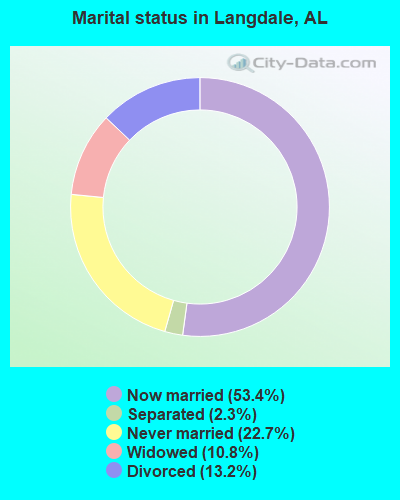
- Never married: 22.7%
- Now married: 53.4%
- Separated: 2.3%
- Widowed: 10.8%
- Divorced: 13.2%
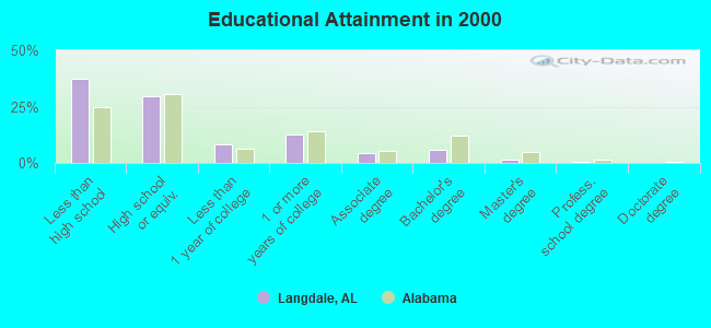
For population 25 years and over in Langdale:
- High school or higher: 62.5%
- Bachelor's degree or higher: 8.1%
- Graduate or professional degree: 2.3%
- Unemployed: 5.6%
- Mean travel time to work (commute): 20.1 minutes
| Here: | 13.5 |
| Alabama average: | 13.2 |
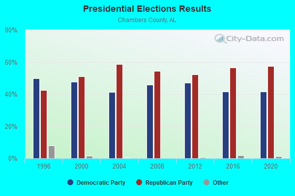
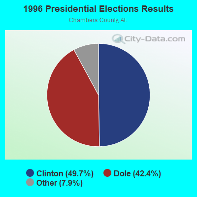
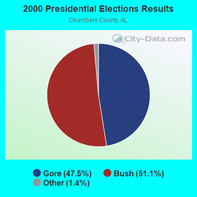
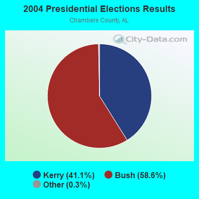
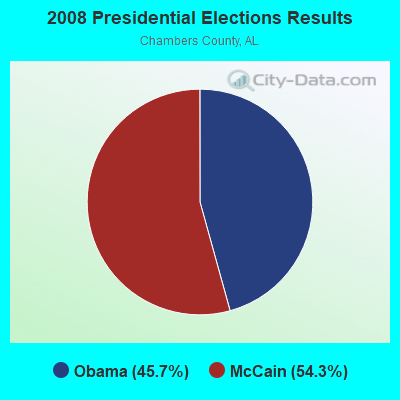
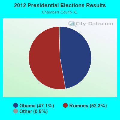
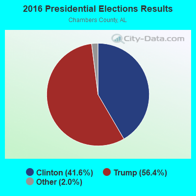

Graphs represent county-level data. Detailed 2008 Election Results
Religion statistics for Langdale, AL (based on Chambers County data)
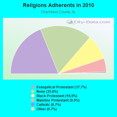
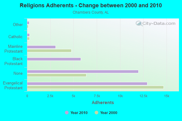
| Religion | Adherents | Congregations |
|---|---|---|
| Evangelical Protestant | 12,903 | 62 |
| Black Protestant | 5,780 | 21 |
| Mainline Protestant | 3,080 | 33 |
| Catholic | 249 | 1 |
| Other | 239 | 2 |
| None | 11,964 | - |
Food Environment Statistics:
| Chambers County: | 2.02 / 10,000 pop. |
| Alabama: | 1.89 / 10,000 pop. |
| This county: | 0.29 / 10,000 pop. |
| State: | 0.20 / 10,000 pop. |
| Here: | 1.15 / 10,000 pop. |
| Alabama: | 0.65 / 10,000 pop. |
| Here: | 6.91 / 10,000 pop. |
| Alabama: | 6.32 / 10,000 pop. |
| Here: | 4.61 / 10,000 pop. |
| State: | 5.75 / 10,000 pop. |
| Here: | 15.1% |
| Alabama: | 11.8% |
| This county: | 35.7% |
| Alabama: | 31.7% |
| Chambers County: | 7.0% |
| Alabama: | 13.5% |
Strongest AM radio stations in Langdale:
- WRLA (1490 AM; 1 kW; WEST POINT, GA; Owner: CASEY NETWORK, LLC)
- WGSE (720 AM; daytime; 8 kW; HOGANSVILLE, GA; Owner: CITICASTERS LICENSES, L.P.)
- WPLV (1310 AM; 1 kW; WEST POINT, GA; Owner: QANTUM OF AUBURN LICENSE COMPANY, LLC)
- WGST (640 AM; 50 kW; ATLANTA, GA; Owner: CITICASTERS LICENSES, L.P.)
- WDAK (540 AM; 5 kW; COLUMBUS, GA; Owner: CLEAR CHANNEL BROADCASTING LICENSES, INC.)
- WTLM (1520 AM; daytime; 5 kW; OPELIKA, AL; Owner: QANTUM OF AUBURN LICENSE COMPANY, LLC)
- WKNG (1060 AM; daytime; 50 kW; TALLAPOOSA, GA; Owner: WKNG, INC.)
- WNSI (810 AM; 50 kW; JACKSONVILLE, AL; Owner: UNITED BROADCASTING NETWORK, INC.)
- WSB (750 AM; 50 kW; ATLANTA, GA; Owner: CXR HOLDINGS, INC.)
- WCNN (680 AM; 50 kW; NORTH ATLANTA, GA; Owner: DICKEY BROADCASTING COMPANY)
- WGUN (1010 AM; 50 kW; ATLANTA, GA; Owner: WGUN, INC.)
- WMAC (940 AM; 50 kW; MACON, GA; Owner: CUMULUS LICENSING CORP.)
- WMLB (1160 AM; 50 kW; EAST POINT, GA; Owner: ATLANTA AREA BROADCASTING, INC.)
Strongest FM radio stations in Langdale:
- WEBT (91.5 FM; LANGDALE, AL; Owner: LANGDALE ED. BROADCASTING FOUNDATION)
- WRLD-FM (95.3 FM; VALLEY, AL; Owner: ABG GEORGIA, LLC)
- WCJM-FM (100.9 FM; WEST POINT, GA; Owner: QANTUM OF AUBURN LICENSE COMPANY, LLC)
- WSTH-FM (106.1 FM; ALEXANDER CITY, AL; Owner: CLEAR CHANNEL BROADCASTING LICENSES, INC.)
- WVFJ-FM (93.3 FM; MANCHESTER, GA; Owner: PROVIDENT BROADCASTING COMPANY)
- WCGQ (107.3 FM; COLUMBUS, GA; Owner: ABG GEORGIA, LLC)
- WMXA (96.7 FM; OPELIKA, AL; Owner: QANTUM OF AUBURN LICENSE COMPANY, LLC)
- WJSP-FM (88.1 FM; WARM SPRINGS, GA; Owner: GEORGIA PUBLIC TELECOMMUNICATIONS COMMISSION)
- WYFK (89.5 FM; COLUMBUS, GA; Owner: BIBLE BROADCASTING NETWORK, INC.)
- WKZJ (95.7 FM; GREENVILLE, GA; Owner: DAVIS B/CASTING OF COLUMBUS, INC)
- WALR-FM (104.1 FM; LA GRANGE, GA; Owner: CXR HOLDINGS, INC.)
- WTBJ (91.3 FM; OXFORD, AL; Owner: TRINITY CHRISTIAN ACADEMY)
- WKKR (97.7 FM; AUBURN, AL; Owner: QANTUM OF AUBURN LICENSE COMPANY, LLC)
- WMAX-FM (105.3 FM; BOWDON, GA; Owner: CLEAR CHANNEL BROADCASTING LICENSES, INC.)
- WOAK (90.9 FM; LA GRANGE, GA; Owner: OAKSIDE CHRISTIAN SCHOOL)
- W220AN (91.9 FM; LA GRANGE, ETC., GA; Owner: FAMILY STATIONS, INC.)
- W212AP (90.3 FM; NOTASULGA, ETC., AL; Owner: FAMILY STATIONS, INC.)
- WELR-FM (102.3 FM; ROANOKE, AL; Owner: EAGLE'S NEST, INC.)
- WMGP (98.1 FM; HOGANSVILLE, GA; Owner: CITICASTERS LICENSES, L.P.)
- WGSY (100.1 FM; PHENIX CITY, AL; Owner: CLEAR CHANNEL BROADCASTING LICENSES, INC.)
TV broadcast stations around Langdale:
- WSWS-TV (Channel 66; OPELIKA, AL; Owner: PAPPAS TELECASTING OF OPELIKA)
- WTVM (Channel 9; COLUMBUS, GA; Owner: RAYCOM AMERICA, INC.)
- WRBL (Channel 3; COLUMBUS, GA; Owner: MEDIA GENERAL BROADCASTING OF SO. CAROLINA HOLDINGS, INC.)
- WLTZ (Channel 38; COLUMBUS, GA; Owner: LEWIS BROADCASTING CORPORATION)
- WJSP-TV (Channel 28; COLUMBUS, GA; Owner: GEORGIA PUBLIC TELECOMMUNICATIONS COMMISSION)
- WXTX (Channel 54; COLUMBUS, GA; Owner: FISHER BROADCASTING - GEORGIA, L.L.C.)
- WCGT-LP (Channel 16; COLUMBUS, GA; Owner: COLUMBUS TELEVISION, INC.)
- W55CR (Channel 55; ATLANTA, GA; Owner: WORD OF GOD FELLOWSHIP, INC.)
- W04DB (Channel 4; ATLANTA, GA; Owner: VVILPTV, INC.)
- W18CD (Channel 18; OPELIKA, AL; Owner: TRINITY BROADCASTING NETWORK)
- WCAG-LP (Channel 33; LA GRANGE, GA; Owner: GEORGIA-ALABAMA BROADCASTING, INC.)
FCC Registered Broadcast Land Mobile Towers:
2- Hospital 4800 48th St (Lat: 32.824583 Lon: -85.168556), Call Sign: KUS546,
Assigned Frequencies: 155.280 MHz, 155.340 MHz, 463.000 MHz, 463.025 MHz, 463.050 MHz, 463.075 MHz, 463.100 MHz, 463.125 MHz, 463.150 MHz, 463.175 MHz, Grant Date: 12/12/1996, Expiration Date: 01/07/2002, Cancellation Date: 05/05/2002, Registrant: George H Lanier Memorial Hospital, 4800 48th St, Valley, AL 36854, Phone: (205) 756-3111
- 2641 64th Blvd (Lat: 32.803472 Lon: -85.180222), Call Sign: KNBS811, Licensee ID: L00000301,
Assigned Frequencies: 451.100 MHz, 456.100 MHz, 456.475 MHz, 456.675 MHz, Grant Date: 06/07/1999, Expiration Date: 06/07/2004, Cancellation Date: 03/29/2002, Registrant: Alabama Power Company, C/O Scs, 600 North 18th Street / Bin 5n-8485, Birmingham, AL 35203-8485, Phone: (205) 257-3227, Fax: (205) 257-3636, Email:
FCC Registered Microwave Towers:
1- STATION, 2519 64th Blvd (Lat: 32.803444 Lon: -85.180194), Overall height: 22.9 m, Call Sign: WEE435,
Assigned Frequencies: 956.100 MHz, Grant Date: 10/20/1994, Expiration Date: 10/20/1999, Cancellation Date: 05/28/1997, Phone: (205) 250-2208
FCC Registered Amateur Radio Licenses:
2- Call Sign: WA4AFA, Licensee ID: L00791684, Grant Date: 01/02/2004, Expiration Date: 02/08/2014, Cancellation Date: 02/09/2016, Certifier: Charles H Bell Jr, Registrant: Charles H Bell Jr, 2507 61st, Langdale, AL 36864
- Call Sign: WA4SLV, Licensee ID: L00798131, Grant Date: 01/14/2004, Expiration Date: 04/12/2014, Cancellation Date: 04/13/2016, Certifier: Vernon Moon, Registrant: Vernon Moon, 1500 54th St, Langdale, AL 36864
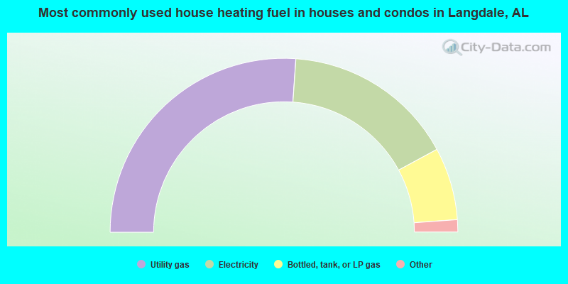
- 52.2%Utility gas
- 32.0%Electricity
- 13.5%Bottled, tank, or LP gas
- 2.0%Wood
- 0.4%Fuel oil, kerosene, etc.
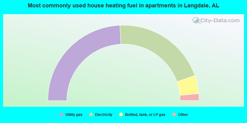
- 48.5%Utility gas
- 40.7%Electricity
- 7.9%Bottled, tank, or LP gas
- 1.5%Fuel oil, kerosene, etc.
- 0.9%No fuel used
- 0.5%Wood
Langdale compared to Alabama state average:
- Median house value below state average.
- Unemployed percentage below state average.
- Hispanic race population percentage significantly below state average.
- Median age below state average.
- Foreign-born population percentage significantly below state average.
- Renting percentage significantly below state average.
- Length of stay since moving in significantly above state average.
- Number of rooms per house significantly below state average.
- House age significantly below state average.
- Institutionalized population percentage significantly above state average.
- Percentage of population with a bachelor's degree or higher significantly below state average.
Langdale on our top lists:
- #2 on the list of "Top 101 cities with largest percentage of males in occupations: textile, apparel, and furnishings workers (population 5,000+)"
- #4 on the list of "Top 101 cities with largest percentage of females in occupations: communications equipment operators (population 5,000+)"
- #4 on the list of "Top 101 cities with largest percentage of males in industries: textile mills and textile products (population 5,000+)"
- #8 on the list of "Top 101 cities with largest percentage of females in industries: textile mills and textile products (population 5,000+)"
- #10 on the list of "Top 101 cities with largest percentage of females in occupations: textile, apparel, and furnishings workers (population 5,000+)"
- #21 on the list of "Top 101 cities with largest percentage of females in occupations: other production occupations including supervisors (population 5,000+)"
- #26 on the list of "Top 101 cities with largest percentage of males in occupations: laborers and material movers, hand (population 5,000+)"
- #32 on the list of "Top 101 cities with largest percentage of males in occupations: electrical equipment mechanics and other installation, maintenance, and repair occupations including supervisors (population 5,000+)"
- #52 on the list of "Top 101 cities with largest percentage of males in industries: used merchandise, gift, novelty, and souvenir, and other miscellaneous stores (population 5,000+)"
- #75 on the list of "Top 101 cities with largest percentage of females in industries: gasoline stations (population 5,000+)"
- #76 on the list of "Top 101 cities with largest percentage of males in industries: plastics and rubber products (population 5,000+)"
- #80 on the list of "Top 101 cities with largest percentage of females in industries: recyclable material merchant wholesalers (population 5,000+)"
- #84 on the list of "Top 101 cities with largest percentage of males in industries: recyclable material merchant wholesalers (population 5,000+)"
- #85 on the list of "Top 101 cities with largest percentage of males in industries: nonmetallic mineral products (population 5,000+)"
- #5 (36854) on the list of "Top 101 zip codes with the lowest 2012 average reported profit/loss from business (pop 5,000+)"
- #27 on the list of "Top 101 counties with the lowest ground withdrawal of fresh water for public supply"