Burke, Vermont
Submit your own pictures of this town and show them to the world
- OSM Map
- Google Map
- MSN Map
Population change since 2000: +11.6%
 |
| Males: 871 | |
| Females: 882 |
| Median resident age: | 40.1 years |
| Vermont median age: | 45.8 years |
Zip codes: 05871.
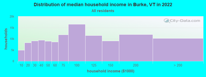
| Burke: | $63,791 |
| VT: | $73,991 |
Estimated per capita income in 2022: $45,239 (it was $20,697 in 2000)
Burke town income, earnings, and wages data
Estimated median house or condo value in 2022: $227,836 (it was $88,500 in 2000)
| Burke: | $227,836 |
| VT: | $304,700 |
Mean prices in 2022: all housing units: $260,980; detached houses: $279,604; townhouses or other attached units: $224,498; in 2-unit structures: $313,991; in 3-to-4-unit structures: $254,854; in 5-or-more-unit structures: $182,529; mobile homes: $88,292; occupied boats, rvs, vans, etc.: $12,813
Detailed information about poverty and poor residents in Burke, VT


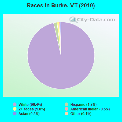
- 1,69096.4%White alone
- 291.7%Hispanic
- 171.0%Two or more races
- 90.5%American Indian alone
- 50.3%Asian alone
- 20.1%Other race alone
- 10.06%Black alone
Races in Burke detailed stats: ancestries, foreign born residents, place of birth
 Recent articles from our blog. Our writers, many of them Ph.D. graduates or candidates, create easy-to-read articles on a wide variety of topics.
Ancestries: English (17.5%), Irish (15.5%), French (14.8%), French Canadian (9.7%), German (8.5%), United States (8.5%).
Current Local Time: EST time zone
Land area: 34.1 square miles.
Population density: 51 people per square mile (very low).
35 residents are foreign born (1.3% North America, 0.8% Europe).
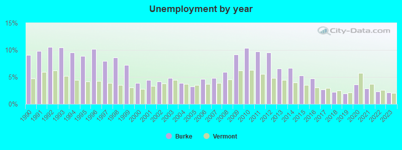
| This town: | 2.2% |
| Vermont: | 3.8% |
| Burke town: | 1.6% ($1,421) |
| Vermont: | 2.0% ($2,196) |
Nearest city with pop. 50,000+: Portland, ME  (106.4 miles , pop. 64,249).
Nearest city with pop. 200,000+: Boston, MA (164.5 miles , pop. 589,141).
Nearest city with pop. 1,000,000+: Bronx, NY (278.3 miles , pop. 1,332,650).
Nearest cities:
), ), ), ), )Latitude: 44.62 N, Longitude: 71.95 W
Area code commonly used in this area: 802
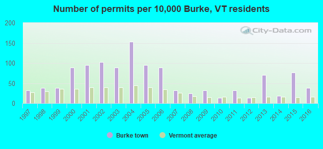
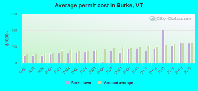
Single-family new house construction building permits:
- 2016: 6 buildings, average cost: $246,000
- 2015: 12 buildings, average cost: $250,000
- 2014: 3 buildings, average cost: $211,200
- 2013: 11 buildings, average cost: $404,500
- 2012: 2 buildings, average cost: $181,000
- 2011: 5 buildings, average cost: $150,000
- 2010: 2 buildings, average cost: $180,000
- 2009: 5 buildings, average cost: $175,000
- 2008: 4 buildings, average cost: $128,300
- 2007: 5 buildings, average cost: $152,000
- 2006: 14 buildings, average cost: $17,800
- 2005: 15 buildings, average cost: $150,000
- 2004: 24 buildings, average cost: $138,800
- 2003: 14 buildings, average cost: $132,800
- 2002: 16 buildings, average cost: $121,400
- 2001: 15 buildings, average cost: $121,400
- 2000: 14 buildings, average cost: $118,000
- 1999: 6 buildings, average cost: $91,700
- 1998: 6 buildings, average cost: $91,700
- 1997: 5 buildings, average cost: $91,700
| Here: | 2.1% |
| Vermont: | 2.0% |
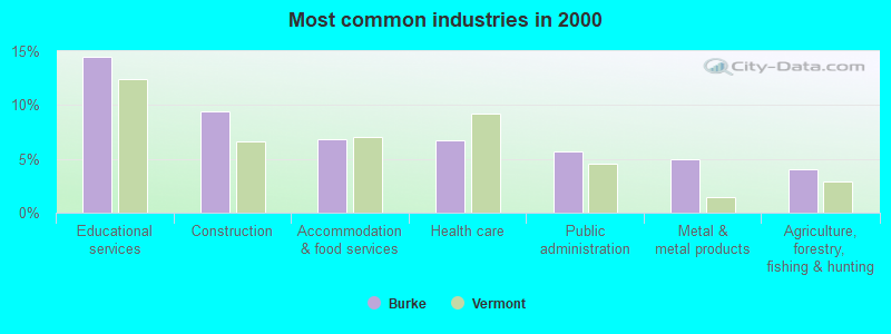
- Educational services (14.4%)
- Construction (9.4%)
- Accommodation & food services (6.9%)
- Health care (6.8%)
- Public administration (5.7%)
- Metal & metal products (5.0%)
- Agriculture, forestry, fishing & hunting (4.1%)
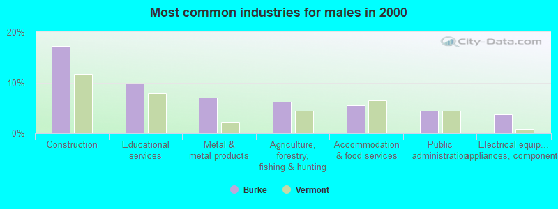
- Construction (17.3%)
- Educational services (9.8%)
- Metal & metal products (7.1%)
- Agriculture, forestry, fishing & hunting (6.2%)
- Accommodation & food services (5.5%)
- Public administration (4.4%)
- Electrical equipment, appliances, components (3.8%)
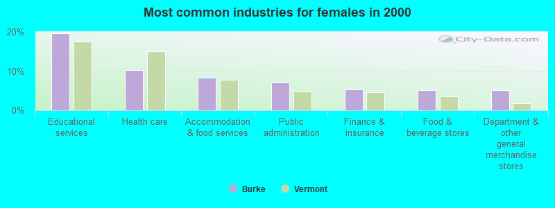
- Educational services (19.6%)
- Health care (10.3%)
- Accommodation & food services (8.3%)
- Public administration (7.1%)
- Finance & insurance (5.4%)
- Food & beverage stores (5.1%)
- Department & other general merchandise stores (5.1%)
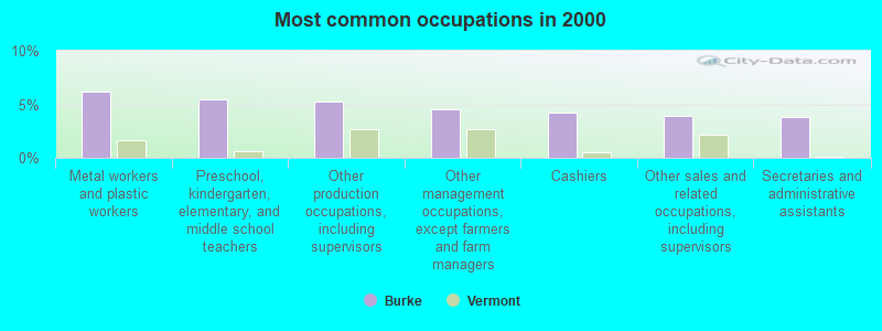
- Metal workers and plastic workers (6.2%)
- Preschool, kindergarten, elementary, and middle school teachers (5.5%)
- Other production occupations, including supervisors (5.2%)
- Other management occupations, except farmers and farm managers (4.5%)
- Cashiers (4.2%)
- Other sales and related occupations, including supervisors (4.0%)
- Secretaries and administrative assistants (3.8%)
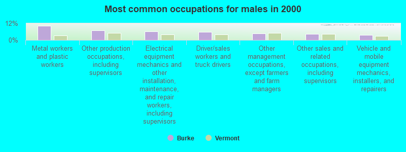
- Metal workers and plastic workers (10.2%)
- Other production occupations, including supervisors (6.9%)
- Electrical equipment mechanics and other installation, maintenance, and repair workers, including supervisors (6.2%)
- Driver/sales workers and truck drivers (5.8%)
- Other management occupations, except farmers and farm managers (4.7%)
- Other sales and related occupations, including supervisors (4.2%)
- Vehicle and mobile equipment mechanics, installers, and repairers (3.8%)
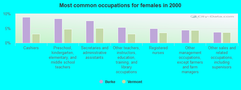
- Cashiers (8.8%)
- Preschool, kindergarten, elementary, and middle school teachers (8.3%)
- Secretaries and administrative assistants (7.6%)
- Other teachers, instructors, education, training, and library occupations (5.4%)
- Registered nurses (4.9%)
- Other management occupations, except farmers and farm managers (4.4%)
- Other sales and related occupations, including supervisors (3.7%)
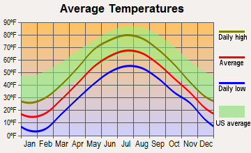
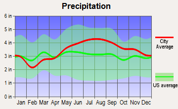
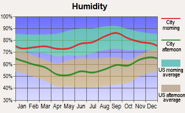
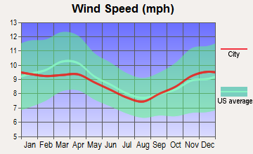
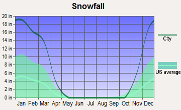
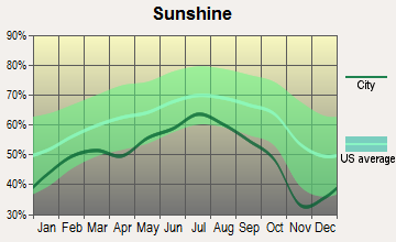
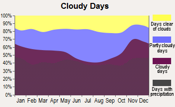
Average climate in Burke, Vermont
Based on data reported by over 4,000 weather stations
(lower is better)
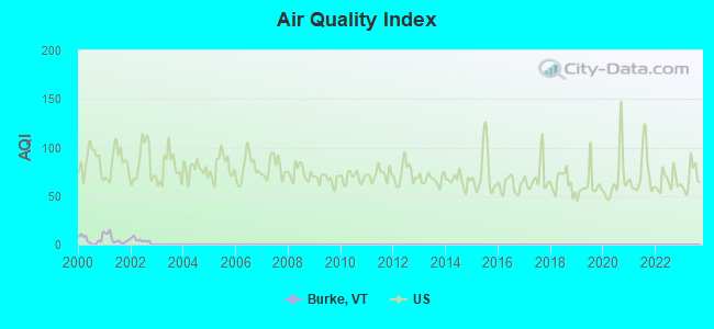
Air Quality Index (AQI) level in 2002 was 4.67. This is significantly better than average.
| City: | 4.67 |
| U.S.: | 72.56 |
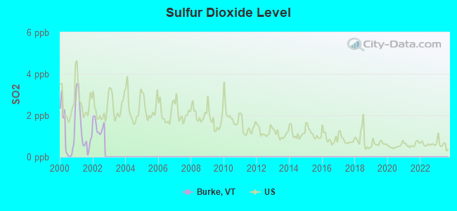
Sulfur Dioxide (SO2) [ppb] level in 2002 was 1.47. This is about average. Closest monitor was 21.6 miles away from the city center.
| City: | 1.47 |
| U.S.: | 1.51 |
Earthquake activity:
Burke-area historical earthquake activity is significantly above Vermont state average. It is 73% smaller than the overall U.S. average.On 4/20/2002 at 10:50:47, a magnitude 5.3 (5.3 ML, Depth: 3.0 mi, Class: Moderate, Intensity: VI - VII) earthquake occurred 86.2 miles away from Burke center
On 4/20/2002 at 10:50:47, a magnitude 5.2 (5.2 MB, 4.2 MS, 5.2 MW, 5.0 MW) earthquake occurred 87.4 miles away from the city center
On 10/7/1983 at 10:18:46, a magnitude 5.3 (5.1 MB, 5.3 LG, 5.1 ML) earthquake occurred 126.8 miles away from the city center
On 1/19/1982 at 00:14:42, a magnitude 4.7 (4.5 MB, 4.7 MD, 4.5 LG, Class: Light, Intensity: IV - V) earthquake occurred 79.1 miles away from Burke center
On 10/16/2012 at 23:12:25, a magnitude 4.7 (4.7 ML, Depth: 10.0 mi) earthquake occurred 95.5 miles away from Burke center
On 6/16/1995 at 12:13:11, a magnitude 3.8 (3.8 LG, Depth: 3.1 mi, Class: Light, Intensity: II - III) earthquake occurred 22.9 miles away from the city center
Magnitude types: regional Lg-wave magnitude (LG), body-wave magnitude (MB), duration magnitude (MD), local magnitude (ML), surface-wave magnitude (MS), moment magnitude (MW)
Natural disasters:
The number of natural disasters in Caledonia County (24) is greater than the US average (15).Major Disasters (Presidential) Declared: 21
Emergencies Declared: 1
Causes of natural disasters: Floods: 19, Storms: 16, Heavy Rains: 2, Tropical Storms: 2, Winds: 2, Hurricane: 1, Landslide: 1, Tornado: 1, Winter Storm: 1, Other: 1 (Note: some incidents may be assigned to more than one category).
Hospitals and medical centers near Burke:
- PINES REHAB AND HEALTH CTR (Nursing Home, about 8 miles away; LYNDONVILLE, VT)
- CALEDONIA HOME HEALTH CARE (Home Health Center, about 12 miles away; SAINT JOHNSBURY, VT)
- NORTHEASTERN VERMONT REGIONAL HOSPITAL Critical Access Hospitals (about 13 miles away; SAINT JOHNSBURY, VT)
- ST JOHNSBURY HEALTH AND REHAB (Nursing Home, about 13 miles away; SAINT JOHNSBURY, VT)
- FMC OF ST. JOHNSBURY DIALYSIS (Dialysis Facility, about 13 miles away; SAINT JOHNSBURY, VT)
- UNION HOUSE NURSING HOME (Nursing Home, about 14 miles away; GLOVER, VT)
Colleges/universities with over 2000 students nearest to Burke:
- Norwich University (about 48 miles; Northfield, VT; Full-time enrollment: 4,221)
- Saint Michael's College (about 61 miles; Colchester, VT; FT enrollment: 2,336)
- Plymouth State University (about 61 miles; Plymouth, NH; FT enrollment: 4,838)
- Community College of Vermont (about 62 miles; Winooski, VT; FT enrollment: 3,394)
- University of Vermont (about 63 miles; Burlington, VT; FT enrollment: 11,566)
- Champlain College (about 63 miles; Burlington, VT; FT enrollment: 2,623)
- Dartmouth College (about 66 miles; Hanover, NH; FT enrollment: 6,030)
Points of interest:
Notable locations in Burke: Burke Mountain Campground (A), Burke Mountain Ski Touring Center (B), Burke Mountain Ski Area (C), East Burke Community Library (D), Vermont Childrens Theater (E), East Burke Volunteer Fire Department (F), West Burke Fire Department (G). Display/hide their locations on the map
Church in Burke: East Burke Congregational Church (A). Display/hide its location on the map
Cemeteries: Hillside Cemetery (1), Howland Cemetery (2), Woodmont Cemetery (3), Burke Green Cemetery (4). Display/hide their locations on the map
Lake: Duck Pond (A). Display/hide its location on the map
Streams, rivers, and creeks: Sutton River (A), Roundy Brook (B), Dish Mill Brook (C), Flower Brook (D). Display/hide their locations on the map
Birthplace of: John Q. Farmer - Politician.
Drinking water stations with addresses in Burke and their reported violations in the past:
WEST BURKE HOUSING (Population served: 40, Groundwater):Past health violations:Past monitoring violations:
- MCL, Monthly (TCR) - In OCT-2010, Contaminant: Coliform. Follow-up actions: St Tech Assistance Visit (APR-11-2011), St Formal NOV issued (APR-11-2011), St Public Notif requested (APR-11-2011), St Boil Water Order (APR-11-2011), St Compliance achieved (FEB-11-2013)
- MCL, Monthly (TCR) - In AUG-2008, Contaminant: Coliform. Follow-up actions: St Boil Water Order (AUG-19-2008), St Formal NOV issued (AUG-19-2008), St Tech Assistance Visit (AUG-19-2008), St Public Notif requested (AUG-19-2008), St Compliance achieved (JAN-29-2010)
- Monitoring, Repeat Major (TCR) - In SEP-2008, Contaminant: Coliform (TCR). Follow-up actions: St Formal NOV issued (OCT-22-2008), St Public Notif requested (OCT-22-2008), St Public Notif received (AUG-24-2009), St Compliance achieved (JAN-29-2010)
- Monitoring, Repeat Major (TCR) - In JAN-2006, Contaminant: Coliform (TCR). Follow-up actions: St Formal NOV issued (JUN-12-2006), St Public Notif requested (JUN-12-2006), St Public Notif received (JUL-16-2007), St Compliance achieved (JAN-29-2010)
- One routine major monitoring violation
- 4 minor monitoring violations
- 3 regular monitoring violations
| This town: | 2.4 people |
| Vermont: | 2.3 people |
| This town: | 64.8% |
| Whole state: | 62.5% |
| This town: | 9.5% |
| Whole state: | 9.2% |
Likely homosexual households (counted as self-reported same-sex unmarried-partner households)
- Lesbian couples: 0.8% of all households
- Gay men: 0.5% of all households
| This town: | 13.9% |
| Whole state: | 9.4% |
| This town: | 6.2% |
| Whole state: | 3.6% |
For population 15 years and over in Burke:
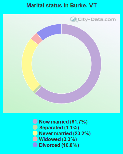
- Never married: 23.2%
- Now married: 61.7%
- Separated: 1.1%
- Widowed: 3.3%
- Divorced: 10.8%
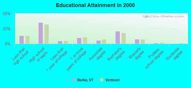
For population 25 years and over in Burke:
- High school or higher: 86.4%
- Bachelor's degree or higher: 30.0%
- Graduate or professional degree: 8.9%
- Unemployed: 3.7%
- Mean travel time to work (commute): 24.0 minutes
| Here: | 11.0 |
| Vermont average: | 11.7 |
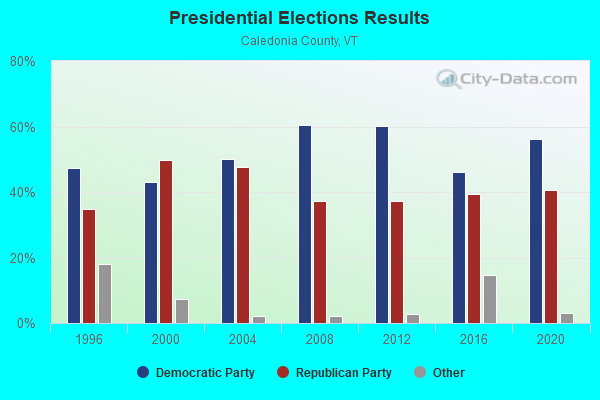
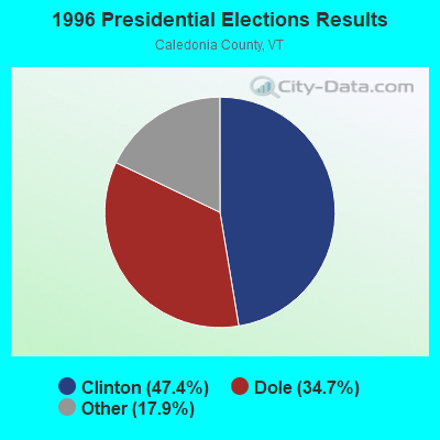
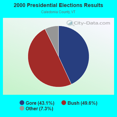
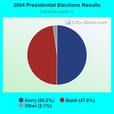
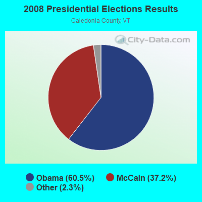
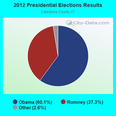
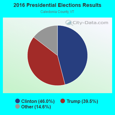
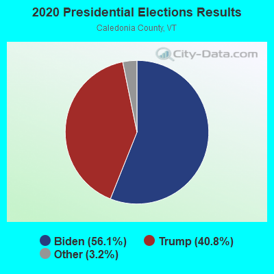
Graphs represent county-level data. Detailed 2008 Election Results
Religion statistics for Burke, VT (based on Caledonia County data)
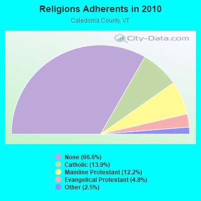
| Religion | Adherents | Congregations |
|---|---|---|
| Catholic | 4,355 | 6 |
| Mainline Protestant | 3,810 | 32 |
| Evangelical Protestant | 1,488 | 15 |
| Other | 780 | 9 |
| None | 20,794 | - |
Food Environment Statistics:
| Caledonia County: | 4.91 / 10,000 pop. |
| Vermont: | 3.84 / 10,000 pop. |
| Caledonia County: | 2.29 / 10,000 pop. |
| Vermont: | 1.95 / 10,000 pop. |
| This county: | 7.53 / 10,000 pop. |
| Vermont: | 6.40 / 10,000 pop. |
| Caledonia County: | 10.14 / 10,000 pop. |
| Vermont: | 11.52 / 10,000 pop. |
| Here: | 7.9% |
| Vermont: | 6.8% |
| Caledonia County: | 24.6% |
| Vermont: | 22.3% |
| This county: | 11.5% |
| State: | 13.3% |
Strongest AM radio stations in Burke:
- WCHP (760 AM; 35 kW; CHAMPLAIN, NY; Owner: CHAMPLAIN RADIO, INC.)
- WDEV (550 AM; 5 kW; WATERBURY, VT; Owner: RADIO VERMONT, INC.)
- WTWN (1100 AM; daytime; 5 kW; WELLS RIVER, VT; Owner: PUFFER BROADCASTING, INC.)
- WSTJ (1340 AM; 1 kW; ST. JOHNSBURY, VT; Owner: VERMONT BROADCAST ASSOCIATES, INC.)
- WRKO (680 AM; 50 kW; BOSTON, MA; Owner: ENTERCOM BOSTON LICENSE, LLC)
- WICY (1490 AM; 50 kW; MALONE, NY; Owner: CARTIER COMMUNICATIONS INC.)
- WNNZ (640 AM; 50 kW; WESTFIELD, MA; Owner: CLEAR CHANNEL BROADCASTING LICENSES, INC.)
- WTME (780 AM; 10 kW; RUMFORD, ME; Owner: MOUNTAIN VALLEY BROADCASTING, INC.)
- WGY (810 AM; 50 kW; SCHENECTADY, NY; Owner: CLEAR CHANNEL BROADCASTING LICENSES, INC.)
- WCRN (830 AM; 50 kW; WORCESTER, MA; Owner: CARTER BROADCASTING CORPORATION)
- WEEI (850 AM; 50 kW; BOSTON, MA; Owner: ENTERCOM BOSTON LICENSE, LLC)
- WVMT (620 AM; 5 kW; BURLINGTON, VT; Owner: SISON BROADCASTING, INC.)
- WBZ (1030 AM; 50 kW; BOSTON, MA; Owner: INFINITY BROADCASTING OPERATIONS, INC.)
Strongest FM radio stations in Burke:
- WGMT (97.7 FM; LYNDON, VT; Owner: VERMONT BROADCAST ASSOCIATES, INC.)
- WPKQ (103.7 FM; NORTH CONWAY, NH; Owner: CITADEL BROADCASTING COMPANY)
- WHOM (94.9 FM; MT. WASHINGTON, NH; Owner: CITADEL BROADCASTING COMPANY)
- WMTK (106.3 FM; LITTLETON, NH; Owner: VERMONT BROADCAST ASSOCIATES, INC.)
- WCKJ (90.5 FM; ST. JOHNSBURY, VT; Owner: CHRISTIAN MINISTRIES, INC.)
- WKXH (105.5 FM; ST. JOHNSBURY, VT; Owner: VERMONT BROADCAST ASSOCIATES, INC.)
- WDOT (95.7 FM; DANVILLE, VT; Owner: MONTPELIER BROADCASTING INC)
- WLKC (103.3 FM; WATERBURY, VT; Owner: RADIO BROADCASTING SERVICES, INC.)
- WVPS (107.9 FM; BURLINGTON, VT; Owner: VERMONT PUBLIC RADIO)
- WEZF (92.9 FM; BURLINGTON, VT; Owner: CAPSTAR TX LIMITED PARTNERSHIP)
- W243AE (96.5 FM; ORLEANS, VT; Owner: CHRISTIAN MINISTRIES, INC.)
- WCVT (101.7 FM; STOWE, VT; Owner: RADIO VERMONT CLASSICS, L.L.C.)
- WXXS (102.3 FM; LANCASTER, NH; Owner: BARRY P. LUNDERVILLE)
- WNCS (104.7 FM; MONTPELIER, VT; Owner: MONTPELIER BROADCASTING, INC.)
- WVFM (105.7 FM; CAMPTON, NH; Owner: DEVON BROADCASTING COMPANY, INC.)
- WDEV-FM (96.1 FM; WARREN, VT; Owner: RADIO VERMONT, INC.)
- WMOO (92.1 FM; DERBY CENTER, VT; Owner: NORTHSTAR MEDIA, INC.)
- WLTN-FM (96.7 FM; LISBON, NH; Owner: PROFILE BROADCASTING CO., INC.)
- WWLR (91.5 FM; LYNDONVILLE, VT; Owner: BOARD OF TRUSTEES, VT. STATE COLLEGE)
TV broadcast stations around Burke:
- WVTB (Channel 20; ST. JOHNSBURY, VT; Owner: VERMONT ETV, INC.)
- W36CP (Channel 36; NEWPORT, VT; Owner: NYN, LLC)
- WLED-TV (Channel 49; LITTLETON, NH; Owner: UNIVERSITY OF NEW HAMPSHIRE)
- National Bridge Inventory (NBI) Statistics
- 15Number of bridges
- 75ft / 22.6mTotal length
- $2,825,000Total costs
- 11,960Total average daily traffic
- 748Total average daily truck traffic
- 12,580Total future (year 2025) average daily traffic
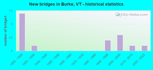
- New bridges - historical statistics
- 71920-1929
- 11930-1939
- 21990-1999
- 32000-2009
- 12010-2019
- 12020-2022
FCC Registered Commercial Land Mobile Towers:
1 (See the full list of FCC Registered Commercial Land Mobile Towers in Burke, VT)FCC Registered Broadcast Land Mobile Towers:
10 (See the full list of FCC Registered Broadcast Land Mobile Towers)FCC Registered Microwave Towers:
4- BURKE MT, Summit Burke Mt Wetv Bldg (Lat: 44.570861 Lon: -71.893417), Type: Ltower, Structure height: 12.2 m, Call Sign: WNTQ233,
Assigned Frequencies: 955.550 MHz, Grant Date: 01/16/2013, Expiration Date: 10/06/2022, Cancellation Date: 03/07/2014, Certifier: Donald J Rendall Jr, Registrant: Green Mountain Power Corporation, 2152 Post Rd, Rutland, VT 05701, Phone: (802) 747-5655, Fax: (802) 747-2137, Email:
- Burke Mountain, 2343 Toll Road (Lat: 44.570972 Lon: -71.894194), Type: Tower, Structure height: 19.8 m, Call Sign: WQJL247,
Assigned Frequencies: 11245.0 MHz, Grant Date: 10/16/2018, Expiration Date: 10/20/2028, Certifier: Willis R Merrill Iii, Registrant: Merrill Information Systems, Inc., 1285 Elliott Rd, Saint Johnsbury, VT 05819, Phone: (802) 748-5866, Email:
- BURKE MTN, Burke Mtn Toll Road (Lat: 44.570861 Lon: -71.893000), Type: Ltower, Structure height: 22.5 m, Overall height: 36.6 m, Call Sign: WQPL554,
Assigned Frequencies: 10915.0 MHz, 10915.0 MHz, 10915.0 MHz, 10955.0 MHz, 10955.0 MHz, 10955.0 MHz, 10955.0 MHz, 10955.0 MHz, 10955.0 MHz, 10955.0 MHz... (+3 more), Grant Date: 04/09/2022, Expiration Date: 06/20/2032, Certifier: Phil Chitwood, Registrant: Vermont Electric Power Company, 366 Pinnacle Ridge Road, Rutland, VT 05701, Phone: (802) 772-3777, Email:
- BURKE MTN, 5.4 Miles Ne'Ly Of Intersection Sr 114 And Us Rt 5 (Lat: 44.570889 Lon: -71.893417), Type: Tower, Structure height: 4.9 m, Overall height: 11.6 m, Call Sign: WHK214,
Assigned Frequencies: 6555.00 MHz, 6685.00 MHz, 6635.00 MHz, 6655.00 MHz, Grant Date: 12/24/2021, Expiration Date: 03/03/2032, Registrant: Utilities Technology Council, 2550 South Clark St., Suite 960, Arlington, VA 22202, Phone: (202) 872-0030, Fax: (202) 872-1331, Email:

- 63.6%Fuel oil, kerosene, etc.
- 19.6%Wood
- 12.2%Bottled, tank, or LP gas
- 2.1%Electricity
- 1.1%Utility gas
- 0.8%Other fuel
- 0.6%Solar energy
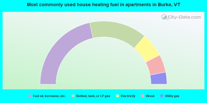
- 42.9%Fuel oil, kerosene, etc.
- 29.4%Bottled, tank, or LP gas
- 12.3%Electricity
- 9.2%Wood
- 6.1%Utility gas
Burke compared to Vermont state average:
- Unemployed percentage significantly below state average.
- Black race population percentage significantly below state average.
- Median age below state average.
- Foreign-born population percentage below state average.
- Length of stay since moving in significantly above state average.
- Number of rooms per house significantly below state average.
- House age significantly below state average.
Burke on our top lists:
- #85 on the list of "Top 101 cities with the most residents born in Other Central America (population 500+)"

|
Total of 3 patent applications in 2008-2024.