Cannelton, Indiana
Submit your own pictures of this city and show them to the world
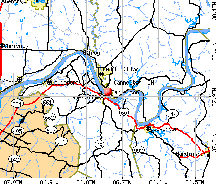
- OSM Map
- General Map
- Google Map
- MSN Map
Population change since 2000: +24.3%
| Males: 821 | |
| Females: 682 |
| Median resident age: | 37.1 years |
| Indiana median age: | 38.2 years |
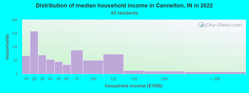
| Cannelton: | $37,827 |
| IN: | $66,785 |
Estimated per capita income in 2022: $22,026 (it was $13,578 in 2000)
Cannelton city income, earnings, and wages data
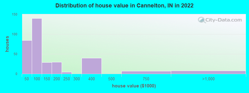
Estimated median house or condo value in 2022: $90,709 (it was $53,100 in 2000)
| Cannelton: | $90,709 |
| IN: | $208,700 |
Mean prices in 2022: all housing units: $111,662; detached houses: $111,981; mobile homes: $93,939
Median gross rent in 2022: $665.
(26.8% for White Non-Hispanic residents, 100.0% for Black residents, 75.0% for Hispanic or Latino residents, 100.0% for other race residents, 82.5% for two or more races residents)
Detailed information about poverty and poor residents in Cannelton, IN
Compare current foreclosures near Cannelton, IN:
| Photo | Address | Area | Beds / Baths | Price | Details |
|---|---|---|---|---|---|

|
#1
Shady Rd
Cannelton, IN 47520
|
1,432 sq. feet
|
1 baths 2 beds |
show details | |

|
#2
Knight St
Cannelton, IN 47520
|
2,191 sq. feet
|
1 baths 2 beds |
show details | |

|
#3
Mount Pleasant Rd
Cannelton, IN 47520
|
806 sq. feet
|
1 baths 2 beds |
show details | |

|
#4
E State Road 66
Cannelton, IN 47520
|
- sq. feet
|
- baths - beds |
show details | |

|
#5
S 4th St Apt 323
Cannelton, IN 47520
|
- sq. feet
|
- baths - beds |
show details | |

|
#6
Knight St
Cannelton, IN 47520
|
- sq. feet
|
- baths - beds |
show details | |

|
#7
Clifton Heights
Cannelton, IN 47520
|
- sq. feet
|
- baths - beds |
show details | |

|
#8
25th St
Tell City, IN 47586
|
2,397 sq. feet
|
1 baths 4 beds |
show details | |

|
#9
10th St
Tell City, IN 47586
|
2,024 sq. feet
|
3 baths 3 beds |
show details | |

|
#10
20th St
Tell City, IN 47586
|
1,092 sq. feet
|
1 baths 3 beds |
show details |
| Photo | Address | Area | Beds / Baths | Price | Details |
|---|---|---|---|---|---|

|
#11
Squirrel Tail Hollow Rd
Hawesville, KY 42348
|
1,983 sq. feet
|
3 baths 5 beds |
show details | |

|
#12
22nd St
Tell City, IN 47586
|
1,110 sq. feet
|
2 baths 2 beds |
show details | |

|
#13
Rose Ln
Grandview, IN 47615
|
1,404 sq. feet
|
2 baths 3 beds |
show details | |

|
#14
State Route 764
Whitesville, KY 42378
|
1,313 sq. feet
|
1 baths 2 beds |
show details | |

|
#15
Sand Hill Rd
Lewisport, KY 42351
|
970 sq. feet
|
1 baths 2 beds |
show details | |

|
#16
River Rd
Lewisport, KY 42351
|
1,320 sq. feet
|
2 baths 4 beds |
show details | |

|
#17
Candy Rd
Saint Meinrad, IN 47577
|
1,685 sq. feet
|
1 baths 2 beds |
show details | |

|
#18
W Houston St
Cloverport, KY 40111
|
1,680 sq. feet
|
2 baths 3 beds |
show details | |

|
#19
E Main St
Cloverport, KY 40111
|
1,792 sq. feet
|
2 baths 4 beds |
show details | |

|
#20
Yelvington Ln
Maceo, KY 42355
|
716 sq. feet
|
1 baths 2 beds |
show details |
| Photo | Address | Area | Beds / Baths | Price | Details |
|---|---|---|---|---|---|

|
#21
2nd St
Grandview, IN 47615
|
925 sq. feet
|
1 baths 3 beds |
show details | |

|
#22
Short Station Rd
Philpot, KY 42366
|
1,584 sq. feet
|
1 baths 3 beds |
show details | |

|
#23
Meadowlane Dr
Lewisport, KY 42351
|
1,228 sq. feet
|
1 baths 3 beds |
show details | |

|
#24
Boteler Rd
Philpot, KY 42366
|
1,736 sq. feet
|
1 baths 3 beds |
show details | |

|
#25
N Highway 259
Hardinsburg, KY 40143
|
1,344 sq. feet
|
2 baths 3 beds |
show details | |

|
#26
Tarfork Easton Ln
Falls Of Rough, KY 40119
|
1,494 sq. feet
|
2 baths 2 beds |
show details | |

|
#27
Pell St
Lewisport, KY 42351
|
864 sq. feet
|
1 baths 3 beds |
show details | |

|
#28
Kelly Cemetery Rd
Maceo, KY 42355
|
1,176 sq. feet
|
1 baths 3 beds |
show details | |

|
#29
Hillbrook Loop
Hardinsburg, KY 40143
|
1,547 sq. feet
|
1 baths 4 beds |
show details | |

|
#30
12th St
Tell City, IN 47586
|
1,435 sq. feet
|
1 baths 3 beds |
show details |
| Photo | Address | Area | Beds / Baths | Price | Details |
|---|---|---|---|---|---|

|
#31
14th St
Tell City, IN 47586
|
2,444 sq. feet
|
1 baths 2 beds |
show details | |

|
#32
State Route 2181
Hawesville, KY 42348
|
1,335 sq. feet
|
1 baths 3 beds |
show details | |

|
#33
Upper Washington Ln
Hawesville, KY 42348
|
1,428 sq. feet
|
1 baths 4 beds |
show details | |

|
#34
Elm Tree Ln
Hawesville, KY 42348
|
1,200 sq. feet
|
2 baths 3 beds |
show details | |

|
#35
Hawesville Easton Rd
Reynolds Station, KY 42368
|
1,008 sq. feet
|
2 baths 3 beds |
show details | |

|
#36
Main St
Tell City, IN 47586
|
1,680 sq. feet
|
1 baths 2 beds |
show details | |

|
#37
13th St
Tell City, IN 47586
|
1,288 sq. feet
|
1 baths 4 beds |
show details | |

|
#38
Terrace Ave
Tell City, IN 47586
|
1,080 sq. feet
|
1 baths 3 beds |
show details | |

|
#39
S 2nd St
Rockport, IN 47635
|
3,520 sq. feet
|
2 baths 4 beds |
show details | |

|
#40
10th St
Tell City, IN 47586
|
1,664 sq. feet
|
1 baths 2 beds |
show details |
| Photo | Address | Area | Beds / Baths | Price | Details |
|---|---|---|---|---|---|

|
#41
Tell St
Tell City, IN 47586
|
1,372 sq. feet
|
1 baths 3 beds |
show details | |

|
#42
Happy Hollow Rd
Hawesville, KY 42348
|
1,232 sq. feet
|
2 baths 3 beds |
show details | |

|
#43
Sutter Loop E
Owensboro, KY 42303
|
1,014 sq. feet
|
1 baths 3 beds |
show details | |

|
#44
Scott Ct
Owensboro, KY 42303
|
1,189 sq. feet
|
1 baths 3 beds |
show details | |

|
#45
Washington St
Tell City, IN 47586
|
988 sq. feet
|
1 baths 2 beds |
show details | |

|
#46
Pestalozzi St
Tell City, IN 47586
|
780 sq. feet
|
1 baths 2 beds |
show details | |

|
#47
State Road 70
Derby, IN 47525
|
1,254 sq. feet
|
1 baths - beds |
show details | |

|
#48
Main St
Tell City, IN 47586
|
1,976 sq. feet
|
1 baths - beds |
show details | |

|
#49
N State Road 545
Saint Meinrad, IN 47577
|
- sq. feet
|
- baths - beds |
show details | |

|
Check over 1 million property listings on Foreclosure.com!
|
browse all offers | |||


- 1,36691.6%White alone
- 523.5%Two or more races
- 332.2%Black alone
- 201.3%Hispanic
- 80.5%American Indian alone
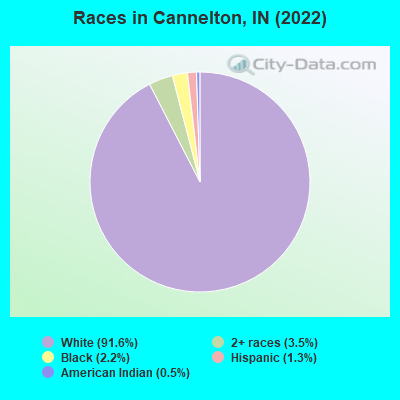
Races in Cannelton detailed stats: ancestries, foreign born residents, place of birth
According to our research of Indiana and other state lists, there was 1 registered sex offender living in Cannelton, Indiana as of May 15, 2024.
The ratio of all residents to sex offenders in Cannelton is 1,644 to 1.
The ratio of registered sex offenders to all residents in this city is much lower than the state average.
Type |
2010 |
2017 |
2018 |
2019 |
|---|---|---|---|---|
| Murders (per 100,000) | 0 (0.0) | 0 (0.0) | 0 (0.0) | 0 (0.0) |
| Rapes (per 100,000) | 0 (0.0) | 0 (0.0) | 0 (0.0) | 0 (0.0) |
| Robberies (per 100,000) | 0 (0.0) | 0 (0.0) | 0 (0.0) | 0 (0.0) |
| Assaults (per 100,000) | 3 (191.9) | 2 (134.9) | 2 (133.7) | 1 (67.6) |
| Burglaries (per 100,000) | 15 (959.7) | 0 (0.0) | 2 (133.7) | 0 (0.0) |
| Thefts (per 100,000) | 23 (1,472) | 5 (337.2) | 9 (601.6) | 2 (135.2) |
| Auto thefts (per 100,000) | 5 (319.9) | 3 (202.3) | 0 (0.0) | 0 (0.0) |
| Arson (per 100,000) | 0 (0.0) | 0 (0.0) | 0 (0.0) | 0 (0.0) |
| City-Data.com crime index | 190.0 | 56.6 | 60.2 | 18.9 |
The City-Data.com crime index weighs serious crimes and violent crimes more heavily. Higher means more crime, U.S. average is 246.1. It adjusts for the number of visitors and daily workers commuting into cities.
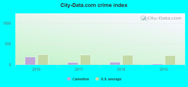
Crime rate in Cannelton detailed stats: murders, rapes, robberies, assaults, burglaries, thefts, arson
Full-time law enforcement employees in 2021, including police officers: 4 (4 officers - 4 male; 0 female).
| Officers per 1,000 residents here: | 2.73 |
| Indiana average: | 2.16 |
 Recent articles from our blog. Our writers, many of them Ph.D. graduates or candidates, create easy-to-read articles on a wide variety of topics.

 | Moving to Tell City (4 replies) |
| Fun Things to Do in Southern Indiana (16 replies) |
| Tell City Indiana (4 replies) |
Latest news from Cannelton, IN collected exclusively by city-data.com from local newspapers, TV, and radio stations
Ancestries: English (32.2%), German (24.7%), American (19.1%), Irish (8.0%).
Current Local Time: CST time zone
Elevation: 426 feet
Land area: 1.48 square miles.
Population density: 1,014 people per square mile (low).

6 residents are foreign born
| This city: | 0.4% |
| Indiana: | 5.6% |
Median real estate property taxes paid for housing units with mortgages in 2022: $623 (0.6%)
Median real estate property taxes paid for housing units with no mortgage in 2022: $640 (1.1%)
Nearest city with pop. 50,000+: Owensboro, KY  (23.2 miles , pop. 54,067).
Nearest city with pop. 200,000+: Louisville, KY (58.3 miles , pop. 256,231).
Nearest city with pop. 1,000,000+: Chicago, IL (276.4 miles , pop. 2,896,016).
Nearest cities:
), ), ), ), ), )Latitude: 37.91 N, Longitude: 86.74 W
Area code commonly used in this area: 270
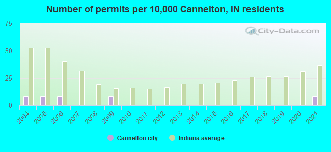
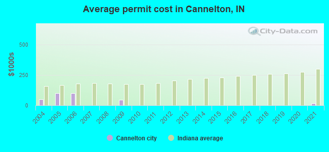
Single-family new house construction building permits:
- 2021: 1 building, cost: $15,000
- 2009: 1 building, cost: $46,000
- 2006: 1 building, cost: $100,000
- 2005: 1 building, cost: $100,000
- 2004: 1 building, cost: $49,500
| Here: | 2.3% |
| Indiana: | 2.8% |
- Furniture & related product manufacturing (12.9%)
- Accommodation & food services (9.8%)
- Metal & metal products (9.1%)
- Electrical equipment, appliances, components (6.2%)
- Construction (4.6%)
- Public administration (4.6%)
- Health care (4.4%)
- Metal & metal products (14.9%)
- Furniture & related product manufacturing (14.0%)
- Construction (9.1%)
- Electrical equipment, appliances, components (7.9%)
- Administrative & support & waste management services (5.4%)
- Public administration (4.1%)
- Nonmetallic mineral products (3.7%)
- Accommodation & food services (17.1%)
- Furniture & related product manufacturing (11.7%)
- Health care (8.8%)
- Educational services (6.2%)
- Public administration (5.0%)
- Electrical equipment, appliances, components (4.6%)
- Department & other general merchandise stores (3.8%)

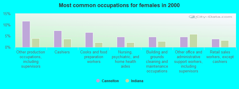
- Other production occupations, including supervisors (15.4%)
- Metal workers and plastic workers (6.0%)
- Building and grounds cleaning and maintenance occupations (4.1%)
- Material recording, scheduling, dispatching, and distributing workers (3.9%)
- Assemblers and fabricators (3.9%)
- Cashiers (3.7%)
- Cooks and food preparation workers (3.7%)
- Other production occupations, including supervisors (19.0%)
- Metal workers and plastic workers (9.1%)
- Material recording, scheduling, dispatching, and distributing workers (6.6%)
- Construction traders workers except carpenters, electricians, painters, plumbers, and construction laborers (6.2%)
- Driver/sales workers and truck drivers (5.4%)
- Vehicle and mobile equipment mechanics, installers, and repairers (5.0%)
- Assemblers and fabricators (5.0%)
- Other production occupations, including supervisors (11.7%)
- Cashiers (7.5%)
- Cooks and food preparation workers (6.7%)
- Nursing, psychiatric, and home health aides (4.6%)
- Building and grounds cleaning and maintenance occupations (4.6%)
- Other office and administrative support workers, including supervisors (4.6%)
- Retail sales workers, except cashiers (3.8%)
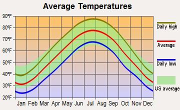
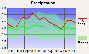
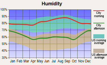
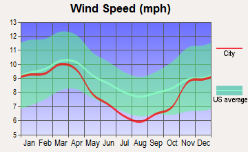
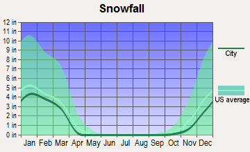
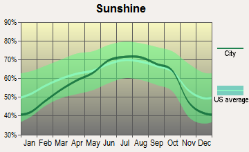
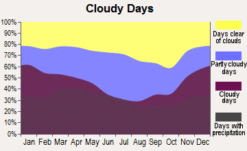
Average climate in Cannelton, Indiana
Based on data reported by over 4,000 weather stations
|
|


(lower is better)
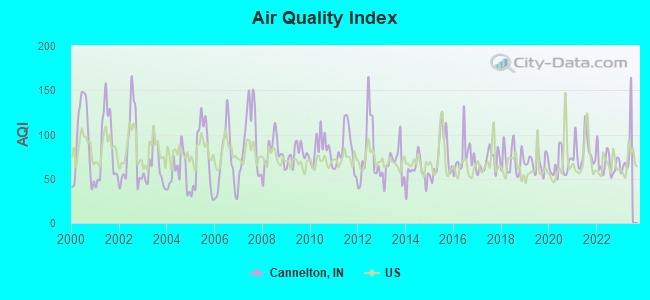
Air Quality Index (AQI) level in 2022 was 68.3. This is about average.
| City: | 68.3 |
| U.S.: | 72.6 |
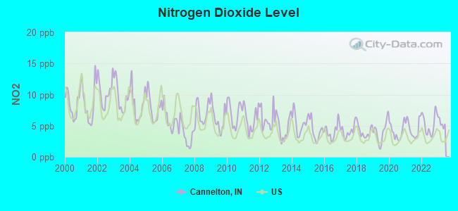
Nitrogen Dioxide (NO2) [ppb] level in 2022 was 5.21. This is about average. Closest monitor was 0.8 miles away from the city center.
| City: | 5.21 |
| U.S.: | 5.11 |
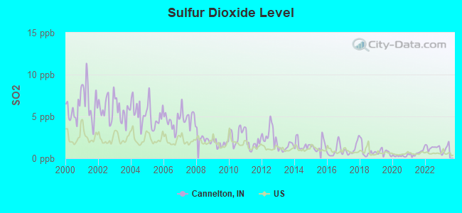
Sulfur Dioxide (SO2) [ppb] level in 2022 was 1.27. This is about average. Closest monitor was 0.8 miles away from the city center.
| City: | 1.27 |
| U.S.: | 1.51 |
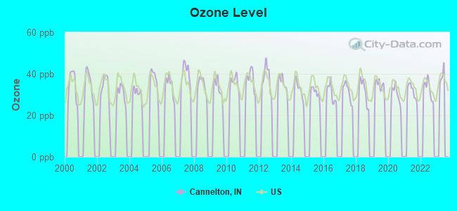
Ozone [ppb] level in 2022 was 32.7. This is about average. Closest monitor was 20.4 miles away from the city center.
| City: | 32.7 |
| U.S.: | 33.3 |
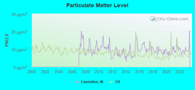
Particulate Matter (PM2.5) [µg/m3] level in 2022 was 8.69. This is about average. Closest monitor was 20.4 miles away from the city center.
| City: | 8.69 |
| U.S.: | 8.11 |
Tornado activity:
Cannelton-area historical tornado activity is slightly below Indiana state average. It is 56% greater than the overall U.S. average.
On 4/3/1974, a category F5 (max. wind speeds 261-318 mph) tornado 11.1 miles away from the Cannelton city center killed 6 people and injured 86 people and caused between $50,000,000 and $500,000,000 in damages.
On 4/3/1974, a category F5 tornado 16.9 miles away from the city center killed 31 people and injured 270 people and caused between $500,000 and $5,000,000 in damages.
Earthquake activity:
Cannelton-area historical earthquake activity is significantly above Indiana state average. It is 166% greater than the overall U.S. average.On 4/18/2008 at 09:36:59, a magnitude 5.4 (5.1 MB, 4.8 MS, 5.4 MW, 5.2 MW, Class: Moderate, Intensity: VI - VII) earthquake occurred 72.7 miles away from Cannelton center
On 4/18/2008 at 09:36:59, a magnitude 5.2 (5.2 MW, Depth: 8.9 mi) earthquake occurred 72.7 miles away from the city center
On 6/18/2002 at 17:37:15, a magnitude 5.0 (4.3 MB, 4.6 MW, 5.0 LG) earthquake occurred 57.0 miles away from the city center
On 6/10/1987 at 23:48:54, a magnitude 5.1 (4.9 MB, 4.4 MS, 4.6 MS, 5.1 LG) earthquake occurred 88.5 miles away from the city center
On 7/27/1980 at 18:52:21, a magnitude 5.2 (5.1 MB, 4.7 MS, 5.0 UK, 5.2 UK) earthquake occurred 153.7 miles away from the city center
On 4/18/2008 at 15:14:16, a magnitude 4.8 (4.5 MB, 4.8 MW, 4.6 MW, Class: Light, Intensity: IV - V) earthquake occurred 71.8 miles away from Cannelton center
Magnitude types: regional Lg-wave magnitude (LG), body-wave magnitude (MB), surface-wave magnitude (MS), moment magnitude (MW)
Natural disasters:
The number of natural disasters in Perry County (19) is greater than the US average (15).Major Disasters (Presidential) Declared: 14
Emergencies Declared: 3
Causes of natural disasters: Floods: 12, Storms: 9, Tornadoes: 6, Winter Storms: 2, Blizzard: 1, Hurricane: 1, Snow: 1, Snowstorm: 1, Wind: 1, Other: 1 (Note: some incidents may be assigned to more than one category).

Hospitals and medical centers near Cannelton:
- GOLDEN LIVING CENTER-LINCOLN HILLS (Nursing Home, about 3 miles away; TELL CITY, IN)
- OAKWOOD HEALTH CAMPUS (Nursing Home, about 3 miles away; TELL CITY, IN)
- DAVITA - TELL CITY DIALYSIS CENTER (Dialysis Facility, about 5 miles away; TELL CITY, IN)
- COMMUNITY ALTERNATIVES SW IN (Hospital, about 7 miles away; TROY, IN)
Colleges/universities with over 2000 students nearest to Cannelton:
- Owensboro Community and Technical College (about 24 miles; Owensboro, KY; Full-time enrollment: 2,754)
- University of Evansville (about 44 miles; Evansville, IN; FT enrollment: 2,688)
- Elizabethtown Community and Technical College (about 51 miles; Elizabethtown, KY; FT enrollment: 3,762)
- University of Southern Indiana (about 52 miles; Evansville, IN; FT enrollment: 9,532)
- Madisonville Community College (about 57 miles; Madisonville, KY; FT enrollment: 2,082)
- University of Louisville (about 58 miles; Louisville, KY; FT enrollment: 16,640)
- Indiana University-Southeast (about 59 miles; New Albany, IN; FT enrollment: 5,050)
Public high school in Cannelton:
- CANNELTON ELEM & HIGH SCHOOL (Students: 261, Location: 3RD/TAYLOR STS, Grades: PK-12)
Private high school in Cannelton:
- CORNERSTONE CHRISTIAN SCHOOL (Students: 8, Location: 117 S 2ND ST, Grades: KG-11)
Points of interest:
Notable location: Cannelton Volunteer Fire Department (A). Display/hide its location on the map
Cemetery: Cliff Cemetery (1). Display/hide its location on the map
Tourist attraction: T N T Amusements (Amusement & Theme Parks; Clifton Heights).
Hotel: Castlebury Inn Bed & Breakfast (615 Washington Street).
Birthplace of: John Russ (baseball) - Baseball player, Tim Whelan - Film director.
Drinking water stations with addresses in Cannelton and their reported violations in the past:
CANNELTON UTILITIES (Population served: 1,209, Groundwater):Past monitoring violations:
- 2 minor monitoring violations
| This city: | 2.2 people |
| Indiana: | 2.5 people |
| This city: | 56.0% |
| Whole state: | 66.9% |
| This city: | 7.6% |
| Whole state: | 6.9% |
Likely homosexual households (counted as self-reported same-sex unmarried-partner households)
- Lesbian couples: 0.0% of all households
- Gay men: 0.3% of all households
36 people in local jails and other confinement facilities (including police lockups) in 2000
For population 15 years and over in Cannelton:
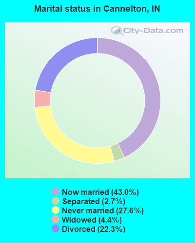
- Never married: 27.6%
- Now married: 43.0%
- Separated: 2.7%
- Widowed: 4.4%
- Divorced: 22.3%
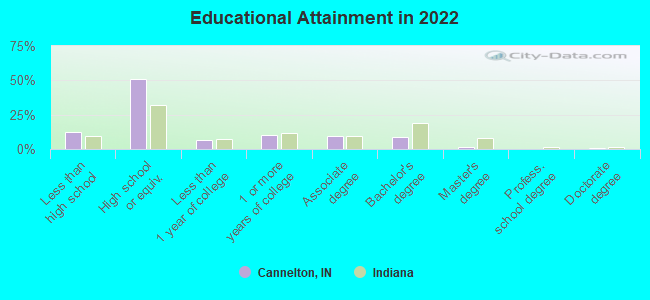
For population 25 years and over in Cannelton:
- High school or higher: 86.3%
- Bachelor's degree or higher: 9.7%
- Graduate or professional degree: 1.8%
- Unemployed: 9.9%
- Mean travel time to work (commute): 24.1 minutes
| Here: | 8.9 |
| Indiana average: | 11.3 |
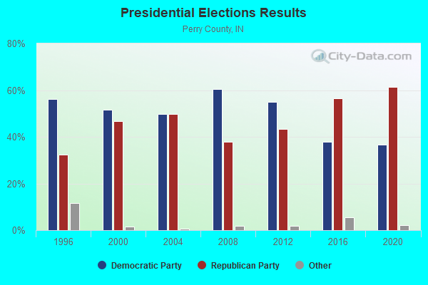
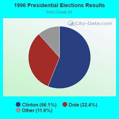
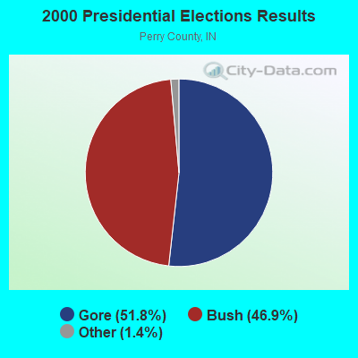
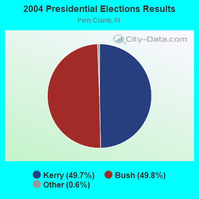
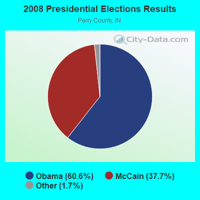
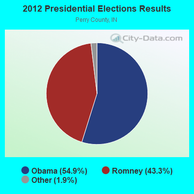
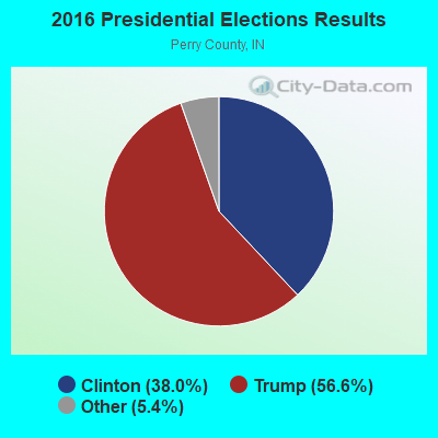
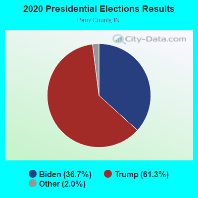
Graphs represent county-level data. Detailed 2008 Election Results
Religion statistics for Cannelton, IN (based on Perry County data)
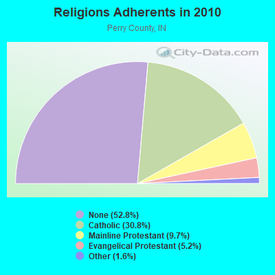
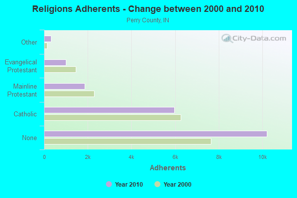
| Religion | Adherents | Congregations |
|---|---|---|
| Catholic | 5,955 | 8 |
| Mainline Protestant | 1,867 | 13 |
| Evangelical Protestant | 999 | 9 |
| Other | 307 | 3 |
| None | 10,210 | - |
Food Environment Statistics:
| Perry County: | 2.11 / 10,000 pop. |
| Indiana: | 1.73 / 10,000 pop. |
| This county: | 7.39 / 10,000 pop. |
| Indiana: | 3.57 / 10,000 pop. |
| Perry County: | 7.92 / 10,000 pop. |
| Indiana: | 6.78 / 10,000 pop. |
| Perry County: | 9.3% |
| Indiana: | 9.2% |
| Perry County: | 28.5% |
| State: | 29.0% |
| Here: | 9.3% |
| Indiana: | 14.3% |
Health and Nutrition:
| This city: | 48.7% |
| Indiana: | 49.3% |
| Cannelton: | 43.6% |
| State: | 46.2% |
| Here: | 28.8 |
| Indiana: | 28.7 |
| Cannelton: | 18.9% |
| Indiana: | 21.3% |
| This city: | 7.5% |
| State: | 10.6% |
| This city: | 6.8 |
| State: | 6.8 |
| This city: | 27.3% |
| State: | 33.9% |
| This city: | 57.7% |
| Indiana: | 56.1% |
| Cannelton: | 75.4% |
| Indiana: | 78.7% |
More about Health and Nutrition of Cannelton, IN Residents
| Local government employment and payroll (March 2022) | |||||
| Function | Full-time employees | Monthly full-time payroll | Average yearly full-time wage | Part-time employees | Monthly part-time payroll |
|---|---|---|---|---|---|
| Other Government Administration | 14 | $7,200 | $6,171 | 5 | $947 |
| Sewerage | 5 | $12,383 | $29,719 | 5 | $4,663 |
| Streets and Highways | 5 | $13,193 | $31,663 | 5 | $4,227 |
| Police Protection - Officers | 5 | $16,958 | $40,699 | 5 | $3,786 |
| Water Supply | 5 | $12,383 | $29,719 | 0 | $0 |
| Solid Waste Management | 5 | $13,193 | $31,663 | 5 | $4,227 |
| Financial Administration | 0 | $0 | 5 | $4,141 | |
| Firefighters | 0 | $0 | 23 | $2,025 | |
| Housing and Community Development (Local) | 0 | $0 | 5 | $789 | |
| Totals for Government | 39 | $75,308 | $23,172 | 58 | $24,804 |
Cannelton government finances - Expenditure in 2017 (per resident):
- Current Operations - Central Staff Services: $43,000 ($28.61)
Water Utilities: $40,000 ($26.61)
Sewerage: $38,000 ($25.28)
Local Fire Protection: $24,000 ($15.97)
Natural Resources - Other: $10,000 ($6.65)
Solid Waste Management: $10,000 ($6.65)
Financial Administration: $3,000 ($2.00)
Regular Highways: $3,000 ($2.00)
Parks and Recreation: $2,000 ($1.33)
Cannelton government finances - Revenue in 2017 (per resident):
- Local Intergovernmental - General Local Government Support: $12,000 ($7.98)
- Miscellaneous - Donations From Private Sources: $3,000 ($2.00)
Fines and Forfeits: $1,000 ($0.67)
- State Intergovernmental - Housing and Community Development: $320,000 ($212.91)
Highways: $15,000 ($9.98)
- Tax - Individual Income: $500,000 ($332.67)
Property: $171,000 ($113.77)
Cannelton government finances - Debt in 2017 (per resident):
- Long Term Debt - Beginning Outstanding - Unspecified Public Purpose: $312,000 ($207.58)
Outstanding Unspecified Public Purpose: $282,000 ($187.62)
Retired Unspecified Public Purpose: $30,000 ($19.96)
Beginning Outstanding - Public Debt for Private Purpose: $6,000 ($3.99)
Outstanding Nonguaranteed - Industrial Revenue: $4,000 ($2.66)
Retired Nonguaranteed - Public Debt for Private Purpose: $2,000 ($1.33)
Cannelton government finances - Cash and Securities in 2017 (per resident):
- Other Funds - Cash and Securities: $10,000 ($6.65)
- Sinking Funds - Cash and Securities: $25,000 ($16.63)
Businesses in Cannelton, IN
- RadioShack: 1
Strongest AM radio stations in Cannelton:
- WKCM (1160 AM; 2 kW; HAWESVILLE, KY; Owner: HANCOCK COMMUNICATIONS, INC.)
- WTCJ (1230 AM; 1 kW; TELL CITY, IN; Owner: HANCOCK COMMUNICATIONS, INC.)
- WHAS (840 AM; 50 kW; LOUISVILLE, KY; Owner: CLEAR CHANNEL BROADCASTING LICENSES, INC.)
- WVJS (1420 AM; 5 kW; OWENSBORO, KY; Owner: TSB III, LLC)
- WSM (650 AM; 50 kW; NASHVILLE, TN; Owner: GAYLORD ENTERTAINMENT COMPANY)
- WKDA (1200 AM; 50 kW; NASHVILLE, TN; Owner: RADIO NASHVILLE, INC.)
- WAMB (1160 AM; 50 kW; DONELSON, TN; Owner: GREAT SOUTHERN BROADCASTING COMPANY, INC.)
- WKJK (1080 AM; 10 kW; LOUISVILLE, KY; Owner: CLEAR CHANNEL BROADCASTING LICENSES, INC.)
- WNQM (1300 AM; 50 kW; NASHVILLE, TN; Owner: WNQM. INC.)
- WLAC (1510 AM; 50 kW; NASHVILLE, TN; Owner: CAPSTAR TX LIMITED PARTNERSHIP)
- WLW (700 AM; 50 kW; CINCINNATI, OH; Owner: JACOR BROADCASTING CORPORATION)
- WGBF (1280 AM; 5 kW; EVANSVILLE, IN; Owner: CLEAR CHANNEL BROADCASTING LICENSES, INC.)
- WIBC (1070 AM; 50 kW; INDIANAPOLIS, IN; Owner: EMMIS RADIO LICENSE CORPORATION)
Strongest FM radio stations in Cannelton:
- WTCJ-FM (105.7 FM; TELL CITY, IN; Owner: HANCOCK COMMUNICATIONS, INC.)
- WLME (102.9 FM; CANNELTON, IN; Owner: HANCOCK COMMUNICATIONS, INC)
- WBKR (92.5 FM; OWENSBORO, KY; Owner: REGENT BROADCASTING OF EVANSVILLE/OWENSBORO, INC.)
- WXCM (97.1 FM; HAWESVILLE, KY; Owner: WLME, INC.)
- WGZB-FM (96.5 FM; CORYDON, IN; Owner: BLUE CHIP BROADCASTING LICENSES II, LTD.)
- WSTO (96.1 FM; OWENSBORO, KY; Owner: TSB III, LLC)
- WQKZ (98.5 FM; FERDINAND, IN; Owner: GEM COMMUNICATIONS LLP)
- WBDC (100.9 FM; HUNTINGBURG, IN; Owner: DUBOIS COUNTY BROADCASTING, INC.)
- WNIN-FM (88.3 FM; EVANSVILLE, IN; Owner: TRI-STATE PUBLIC TELEPLEX, INC.)
- WXBC (104.3 FM; HARDINSBURG, KY; Owner: BRECKINRIDGE BROADCASTING CO., INC.)
- WYXY (107.1 FM; BOONVILLE, IN; Owner: BOONVILLE BROADCASTING CO., INC.)
- WULF (94.3 FM; HARDINSBURG, KY; Owner: SKYTOWER COMMUNICATIONS - 94.3, LLC)
- WAXL (103.3 FM; SANTA CLAUS, IN; Owner: DUBOIS COUNTY BROADCASTING, INC.)
- WKDQ (99.5 FM; HENDERSON, KY; Owner: REGENT BROADCASTING OF EVANSVILLE/OWENSBORO, INC.)
- WBIO (94.7 FM; PHILPOT, KY; Owner: THE CROMWELL GROUP, INC OF KENTUCKY)
TV broadcast stations around Cannelton:
- WNIN (Channel 9; EVANSVILLE, IN; Owner: TRI-STATE PUBLIC TELEPLEX, INC.)
- WTVW (Channel 7; EVANSVILLE, IN; Owner: QUORUM OF INDIANA LICENSE, LLC)
- WFIE (Channel 14; EVANSVILLE, IN; Owner: LIBCO, INC.)
- K55HL (Channel 55; CAPE GIRARDEAU, MO; Owner: MS COMMUNICATIONS, LLC)
- Cannelton, Indiana
- Fatal accident count19
- Vehicles involved in fatal accidents24
- Fatal accidents involving drunk persons:9
- Fatalities21
- Persons involved in fatal accidents41
- Pedestrians involved in fatal accidents4
- Indiana average
- Fatal accident count13038
- Vehicles involved in fatal accidents20481
- Fatal accidents involving drunk persons3774
- Fatalities14539
- Persons involved in fatal accidents32278
- Pedestrians involved in fatal accidents1219
- National Bridge Inventory (NBI) Statistics
- 15Number of bridges
- 361ft / 110mTotal length
- 52,656Total average daily traffic
- 4,106Total average daily truck traffic
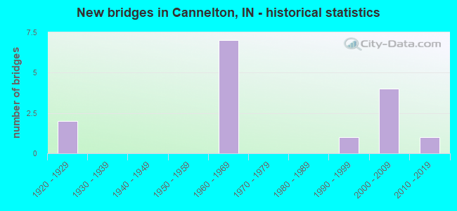
- New bridges - historical statistics
- 21920-1929
- 71960-1969
- 11990-1999
- 42000-2009
- 12010-2019
FCC Registered Cell Phone Towers:
1 (See the full list of FCC Registered Cell Phone Towers in Cannelton)FCC Registered Antenna Towers:
29 (See the full list of FCC Registered Antenna Towers)FCC Registered Broadcast Land Mobile Towers:
2- Lat: 37.912222 Lon: -86.742500, Structure height: 0 m, Call Sign: WPVW287,
Assigned Frequencies: 456.225 MHz, Grant Date: 08/27/2002, Expiration Date: 08/27/2012, Cancellation Date: 10/27/2012, Certifier: Steven L Seibert, Registrant: Palco Enterprisses Inc, 4260 Rapids Rd, Franklin, KY 42134, Phone: (270) 586-5986, Fax: (270) 586-5390, Email:
- 5415 Shady Road (Lat: 37.916278 Lon: -86.717417), Type: Tower, Structure height: 103.6 m, Overall height: 114.3 m, Call Sign: WQED247,
Assigned Frequencies: 853.925 MHz, 852.912 MHz, 852.412 MHz, 851.425 MHz, Grant Date: 04/08/2014, Expiration Date: 10/05/2014, Cancellation Date: 12/06/2014, Certifier: David C Smith, Registrant: State Of (Ipsc) Indiana, Igcn - Rm N340 - 100 North Senate Avenue, Indianapolis, IN 46204, Phone: (317) 234-6513, Fax: (317) 234-6514, Email:
FCC Registered Microwave Towers:
1- TELL CITY, 8115 North Sky Blue Lane (Lat: 37.954333 Lon: -86.710194), Type: Gtower, Structure height: 117.3 m, Overall height: 119.2 m, Call Sign: WQRJ931,
Assigned Frequencies: 6330.66 MHz, 6330.66 MHz, 6330.66 MHz, 6330.66 MHz, 6330.66 MHz, 6330.66 MHz, 6330.66 MHz, 6330.66 MHz, 6330.66 MHz, 6286.19 MHz... (+9 more), Grant Date: 05/02/2023, Expiration Date: 06/03/2033, Certifier: Gregory M Romano, Registrant: Verizon, 5055 Northpointe Pkwy, Alpharetta, GA 30022, Phone: (770) 797-1070, Email:
FCC Registered Amateur Radio Licenses:
9 (See the full list of FCC Registered Amateur Radio Licenses in Cannelton)FAA Registered Aircraft:
2- Aircraft: PIPER PA-28-236 (Category: Land, Seats: 4, Weight: Up to 12,499 Pounds), Engine: LYCOMING 0-540 SERIES (250 HP) (Reciprocating)
N-Number: 43380, N43380, N-43380, Serial Number: 28-8411009, Year manufactured: 1984, Airworthiness Date: 02/08/1984, Certificate Issue Date: 10/04/2012
Registrant (LLC): E'Claire LLC, 4525 Bell Hollow Rd, Cannelton, IN 47520 - Aircraft: BEECH B24R (Category: Land, Seats: 6, Weight: Up to 12,499 Pounds, Speed: 120 mph), Engine: LYCOMING I0360 SER (180 HP) (Reciprocating)
N-Number: 9195S, N9195S, N-9195S, Serial Number: MC-368, Year manufactured: 1975, Airworthiness Date: 08/14/1975, Certificate Issue Date: 06/27/2002
Registrant (Individual): Thomas P Bailey, 6216 Sugar Maple Rd, Cannelton, IN 47520
2003 - 2018 National Fire Incident Reporting System (NFIRS) incidents
- Fire incident types reported to NFIRS in Cannelton, IN
- 7638.6%Structure Fires
- 6030.5%Outside Fires
- 3216.2%Other
- 2914.7%Mobile Property/Vehicle Fires
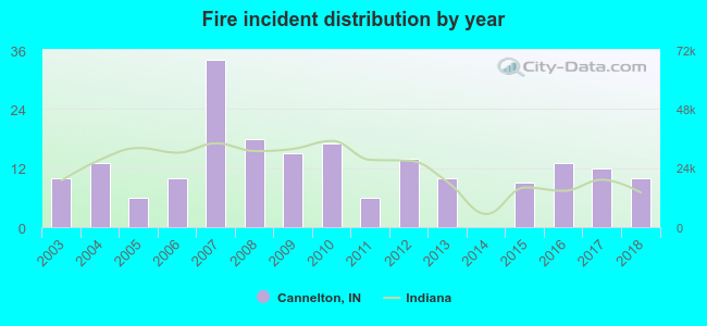 Based on the data from the years 2003 - 2018 the average number of fire incidents per year is 12. The highest number of reported fire incidents - 34 took place in 2007, and the least - 0 in 2014. The data has a constant trend.
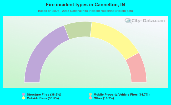 When looking into fire subcategories, the most incidents belonged to: Structure Fires (38.6%), and Outside Fires (30.5%).
| Most common first names in Cannelton, IN among deceased individuals | ||
| Name | Count | Lived (average) |
|---|---|---|
| William | 51 | 72.2 years |
| Mary | 39 | 79.3 years |
| John | 37 | 73.1 years |
| Charles | 32 | 67.4 years |
| James | 30 | 69.3 years |
| Robert | 18 | 71.6 years |
| George | 16 | 70.1 years |
| Walter | 16 | 72.9 years |
| Arthur | 12 | 72.1 years |
| Joseph | 11 | 75.6 years |
| Most common last names in Cannelton, IN among deceased individuals | ||
| Last name | Count | Lived (average) |
|---|---|---|
| Reed | 21 | 75.6 years |
| Bolin | 18 | 68.3 years |
| Young | 17 | 70.7 years |
| Poehlein | 14 | 74.4 years |
| Huber | 13 | 82.4 years |
| Smith | 12 | 70.4 years |
| Sandage | 10 | 58.3 years |
| Kellems | 9 | 76.2 years |
| Schroeder | 9 | 79.0 years |
| Heck | 8 | 83.0 years |
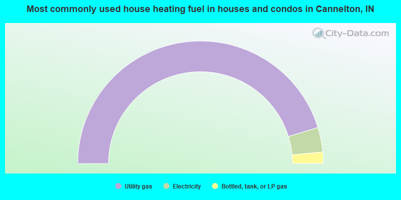
- 90.5%Utility gas
- 6.5%Electricity
- 3.0%Bottled, tank, or LP gas
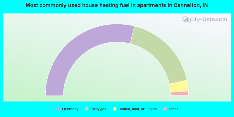
- 58.1%Electricity
- 35.3%Utility gas
- 5.0%Bottled, tank, or LP gas
- 0.9%Wood
- 0.6%Other fuel
Cannelton compared to Indiana state average:
- Median household income below state average.
- Median house value significantly below state average.
- Black race population percentage significantly below state average.
- Hispanic race population percentage significantly below state average.
- Foreign-born population percentage significantly below state average.
- Renting percentage above state average.
- Length of stay since moving in significantly above state average.
- House age above state average.
- Percentage of population with a bachelor's degree or higher below state average.
State forum archive: