Patesville, Kentucky
Submit your own pictures of this place and show them to the world
- OSM Map
- General Map
- Google Map
- MSN Map

| Males: 1,252 | |
| Females: 1,251 |
| Median resident age: | 35.0 years |
| Kentucky median age: | 35.9 years |
Zip code: 42368
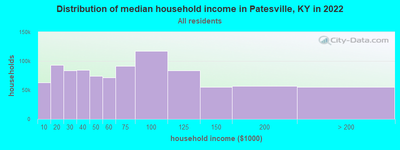
| Patesville: | $62,580 |
| KY: | $59,341 |
Estimated per capita income in 2022: $28,047 (it was $15,038 in 2000)
Patesville CCD income, earnings, and wages data
Estimated median house or condo value in 2022: $102,800 (it was $49,600 in 2000)
| Patesville: | $102,800 |
| KY: | $196,300 |
Detailed information about poverty and poor residents in Patesville, KY
Compare current foreclosures near Patesville, KY:
| Photo | Address | Area | Beds / Baths | Price | Details |
|---|---|---|---|---|---|

|
#1
Webster Ln
Owensboro, KY 42303
|
864 sq. feet
|
1 baths 3 beds |
show details | |

|
#2
Squirrel Tail Hollow Rd
Hawesville, KY 42348
|
1,983 sq. feet
|
3 baths 5 beds |
show details | |

|
#3
25th St
Tell City, IN 47586
|
2,397 sq. feet
|
1 baths 4 beds |
show details | |

|
#4
22nd St
Tell City, IN 47586
|
1,110 sq. feet
|
2 baths 2 beds |
show details | |

|
#5
20th St
Tell City, IN 47586
|
1,092 sq. feet
|
1 baths 3 beds |
show details | |

|
#6
10th St
Tell City, IN 47586
|
2,024 sq. feet
|
3 baths 3 beds |
show details | |

|
#7
State Route 764
Whitesville, KY 42378
|
1,313 sq. feet
|
1 baths 2 beds |
show details | |

|
#8
Hillbrook Loop
Hardinsburg, KY 40143
|
1,547 sq. feet
|
1 baths 4 beds |
show details | |

|
#9
Boteler Rd
Philpot, KY 42366
|
1,736 sq. feet
|
1 baths 3 beds |
show details | |

|
#10
Kelly Cemetery Rd
Maceo, KY 42355
|
1,176 sq. feet
|
1 baths 3 beds |
show details |
| Photo | Address | Area | Beds / Baths | Price | Details |
|---|---|---|---|---|---|

|
#11
Washington St
Tell City, IN 47586
|
988 sq. feet
|
1 baths 2 beds |
show details | |

|
#12
Pestalozzi St
Tell City, IN 47586
|
780 sq. feet
|
1 baths 2 beds |
show details | |

|
#13
14th St
Tell City, IN 47586
|
2,444 sq. feet
|
1 baths 2 beds |
show details | |

|
#14
Scotland Dr
Owensboro, KY 42303
|
2,064 sq. feet
|
2 baths 3 beds |
show details | |

|
#15
Tell St
Tell City, IN 47586
|
1,372 sq. feet
|
1 baths 3 beds |
show details | |

|
#16
10th St
Tell City, IN 47586
|
1,664 sq. feet
|
1 baths 2 beds |
show details | |

|
#17
Main St
Tell City, IN 47586
|
1,680 sq. feet
|
1 baths 2 beds |
show details | |

|
#18
Shady Rd
Cannelton, IN 47520
|
1,432 sq. feet
|
1 baths 2 beds |
show details | |

|
#19
13th St
Tell City, IN 47586
|
1,288 sq. feet
|
1 baths 4 beds |
show details | |

|
#20
12th St
Tell City, IN 47586
|
1,435 sq. feet
|
1 baths 3 beds |
show details |
| Photo | Address | Area | Beds / Baths | Price | Details |
|---|---|---|---|---|---|

|
#21
Old Highway 54
Philpot, KY 42366
|
1,380 sq. feet
|
1 baths 2 beds |
show details | |

|
#22
S Hardin St
Hardinsburg, KY 40143
|
1,120 sq. feet
|
1 baths 2 beds |
show details | |

|
#23
Sand Hill Rd
Lewisport, KY 42351
|
970 sq. feet
|
1 baths 2 beds |
show details | |

|
#24
N Highway 259
Hardinsburg, KY 40143
|
1,344 sq. feet
|
2 baths 3 beds |
show details | |

|
#25
Old Highway 54
Philpot, KY 42366
|
1,088 sq. feet
|
1 baths 2 beds |
show details | |

|
#26
Old State Rd
Philpot, KY 42366
|
1,440 sq. feet
|
1 baths 2 beds |
show details | |

|
#27
Lakeshore Dr
Hardinsburg, KY 40143
|
3,134 sq. feet
|
3 baths 3 beds |
show details | |

|
#28
Pell St
Lewisport, KY 42351
|
864 sq. feet
|
1 baths 3 beds |
show details | |

|
#29
Meadowlane Dr
Lewisport, KY 42351
|
1,228 sq. feet
|
1 baths 3 beds |
show details | |

|
#30
River Rd
Lewisport, KY 42351
|
1,320 sq. feet
|
2 baths 4 beds |
show details |
| Photo | Address | Area | Beds / Baths | Price | Details |
|---|---|---|---|---|---|

|
#31
Scott Ct
Owensboro, KY 42303
|
1,189 sq. feet
|
1 baths 3 beds |
show details | |

|
#32
Terrace Ave
Tell City, IN 47586
|
1,080 sq. feet
|
1 baths 3 beds |
show details | |

|
#33
Yelvington Ln
Maceo, KY 42355
|
716 sq. feet
|
1 baths 2 beds |
show details | |

|
#34
Creek Run Rd
Hardinsburg, KY 40143
|
4,497 sq. feet
|
3 baths 4 beds |
show details | |

|
#35
Upper Washington Ln
Hawesville, KY 42348
|
1,428 sq. feet
|
1 baths 4 beds |
show details | |

|
#36
Hawesville Easton Rd
Reynolds Station, KY 42368
|
1,008 sq. feet
|
2 baths 3 beds |
show details | |

|
#37
Masonville Habit Rd
Philpot, KY 42366
|
1,359 sq. feet
|
1 baths 3 beds |
show details | |

|
#38
W Houston St
Cloverport, KY 40111
|
1,680 sq. feet
|
2 baths 3 beds |
show details | |

|
#39
Happy Hollow Rd
Hawesville, KY 42348
|
1,232 sq. feet
|
2 baths 3 beds |
show details | |

|
#40
Cannonade Loop S
Owensboro, KY 42303
|
1,460 sq. feet
|
2 baths 3 beds |
show details |
| Photo | Address | Area | Beds / Baths | Price | Details |
|---|---|---|---|---|---|

|
#41
State Route 2181
Hawesville, KY 42348
|
1,335 sq. feet
|
1 baths 3 beds |
show details | |

|
#42
Tarfork Easton Ln
Falls Of Rough, KY 40119
|
1,494 sq. feet
|
2 baths 2 beds |
show details | |

|
#43
E Main St
Cloverport, KY 40111
|
1,792 sq. feet
|
2 baths 4 beds |
show details | |

|
#44
Elm Tree Ln
Hawesville, KY 42348
|
1,200 sq. feet
|
2 baths 3 beds |
show details | |

|
#45
Court Dijon
Owensboro, KY 42303
|
1,340 sq. feet
|
2 baths 3 beds |
show details | |

|
#46
Carolyn Ln
Hardinsburg, KY 40143
|
1,372 sq. feet
|
2 baths 3 beds |
show details | |

|
#47
Sutter Loop E
Owensboro, KY 42303
|
1,014 sq. feet
|
1 baths 3 beds |
show details | |

|
#48
Locust Hill Dr
Owensboro, KY 42303
|
1,429 sq. feet
|
1 baths 3 beds |
show details | |

|
#49
Short Station Rd
Philpot, KY 42366
|
1,584 sq. feet
|
1 baths 3 beds |
show details | |

|
Check over 1 million property listings on Foreclosure.com!
|
browse all offers | |||

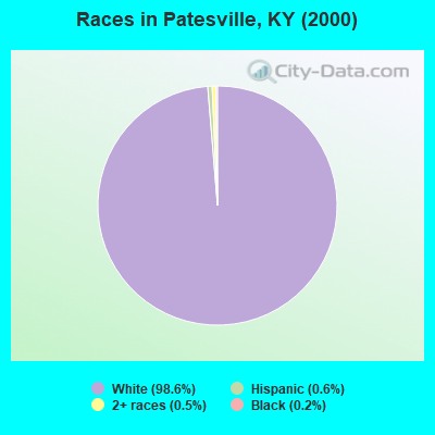
- 2,41998.6%White alone
- 140.6%Hispanic
- 120.5%Two or more races
- 60.2%Black alone
- 20.08%American Indian alone
- 10.04%Asian alone
Races in Patesville detailed stats: ancestries, foreign born residents, place of birth
 Recent articles from our blog. Our writers, many of them Ph.D. graduates or candidates, create easy-to-read articles on a wide variety of topics.
Current Local Time: CST time zone
Elevation: 480 feet
Land area: 89.5 square miles.
Population density: 28 people per square mile (very low).

| Patesville CCD: | 0.8% ($407) |
| Kentucky: | 0.8% ($610) |
Nearest city with pop. 50,000+: Owensboro, KY  (20.6 miles , pop. 54,067).
Nearest city with pop. 200,000+: Louisville, KY (62.7 miles , pop. 256,231).
Nearest city with pop. 1,000,000+: Chicago, IL (285.8 miles , pop. 2,896,016).
Nearest cities:
), ), ), ), )Latitude: 37.77 N, Longitude: 86.74 W
Area code commonly used in this area: 270

| Here: | 4.0% |
| Kentucky: | 3.8% |
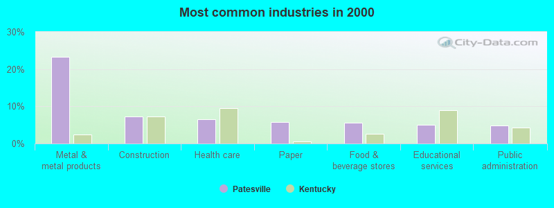
- Metal & metal products (23.2%)
- Construction (7.3%)
- Health care (6.6%)
- Paper (5.8%)
- Food & beverage stores (5.6%)
- Educational services (5.1%)
- Public administration (4.8%)
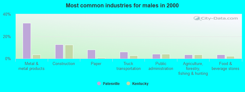
- Metal & metal products (32.1%)
- Construction (12.6%)
- Paper (8.0%)
- Truck transportation (6.0%)
- Public administration (4.1%)
- Agriculture, forestry, fishing & hunting (3.5%)
- Food & beverage stores (3.5%)
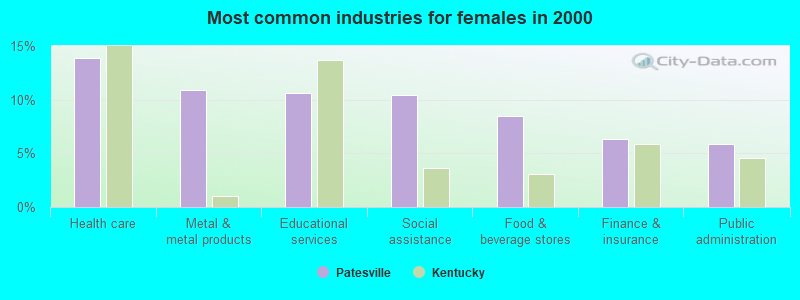
- Health care (13.9%)
- Metal & metal products (10.9%)
- Educational services (10.7%)
- Social assistance (10.4%)
- Food & beverage stores (8.5%)
- Finance & insurance (6.3%)
- Public administration (5.9%)
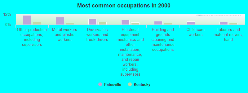
- Other production occupations, including supervisors (11.1%)
- Metal workers and plastic workers (8.9%)
- Driver/sales workers and truck drivers (6.8%)
- Electrical equipment mechanics and other installation, maintenance, and repair workers, including supervisors (5.3%)
- Building and grounds cleaning and maintenance occupations (4.0%)
- Child care workers (3.6%)
- Laborers and material movers, hand (3.3%)
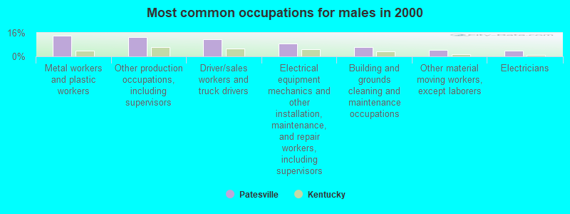
- Metal workers and plastic workers (14.0%)
- Other production occupations, including supervisors (13.2%)
- Driver/sales workers and truck drivers (11.8%)
- Electrical equipment mechanics and other installation, maintenance, and repair workers, including supervisors (8.5%)
- Building and grounds cleaning and maintenance occupations (6.1%)
- Other material moving workers, except laborers (4.3%)
- Electricians (4.1%)

- Child care workers (8.5%)
- Other production occupations, including supervisors (8.0%)
- Laborers and material movers, hand (6.3%)
- Health technologists and technicians (6.3%)
- Other teachers, instructors, education, training, and library occupations (5.0%)
- Cashiers (5.0%)
- Nursing, psychiatric, and home health aides (4.8%)
Average climate in Patesville, Kentucky
Based on data reported by over 4,000 weather stations


(lower is better)
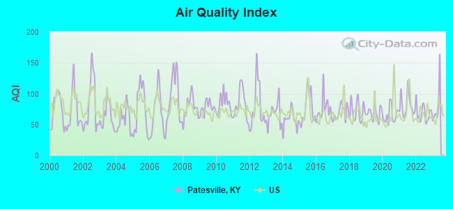
Air Quality Index (AQI) level in 2022 was 68.3. This is about average.
| City: | 68.3 |
| U.S.: | 72.6 |
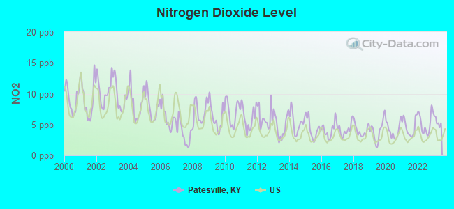
Nitrogen Dioxide (NO2) [ppb] level in 2022 was 5.21. This is about average. Closest monitor was 9.1 miles away from the city center.
| City: | 5.21 |
| U.S.: | 5.11 |
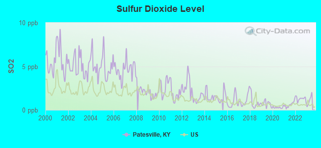
Sulfur Dioxide (SO2) [ppb] level in 2022 was 1.27. This is about average. Closest monitor was 9.1 miles away from the city center.
| City: | 1.27 |
| U.S.: | 1.51 |
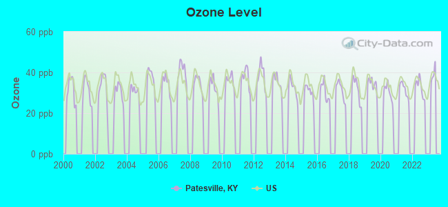
Ozone [ppb] level in 2022 was 32.7. This is about average. Closest monitor was 15.1 miles away from the city center.
| City: | 32.7 |
| U.S.: | 33.3 |
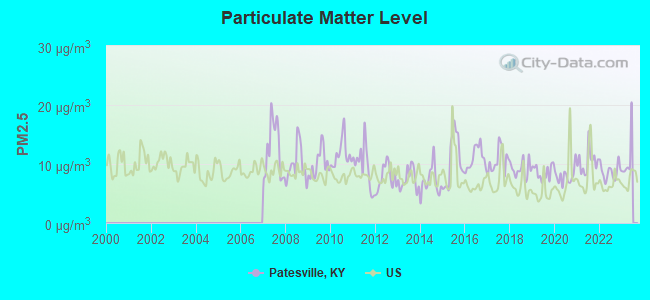
Particulate Matter (PM2.5) [µg/m3] level in 2022 was 8.69. This is about average. Closest monitor was 18.2 miles away from the city center.
| City: | 8.69 |
| U.S.: | 8.11 |
Tornado activity:
Patesville-area historical tornado activity is slightly above Kentucky state average. It is 54% greater than the overall U.S. average.
On 4/3/1974, a category F5 (max. wind speeds 261-318 mph) tornado 12.0 miles away from the Patesville place center killed 31 people and injured 270 people and caused between $500,000 and $5,000,000 in damages.
On 4/3/1974, a category F5 tornado 20.6 miles away from the place center killed 6 people and injured 86 people and caused between $50,000,000 and $500,000,000 in damages.
Earthquake activity:
Patesville-area historical earthquake activity is significantly above Kentucky state average. It is 171% greater than the overall U.S. average.On 4/18/2008 at 09:36:59, a magnitude 5.4 (5.1 MB, 4.8 MS, 5.4 MW, 5.2 MW, Class: Moderate, Intensity: VI - VII) earthquake occurred 78.0 miles away from Patesville center
On 4/18/2008 at 09:36:59, a magnitude 5.2 (5.2 MW, Depth: 8.9 mi) earthquake occurred 78.0 miles away from Patesville center
On 6/18/2002 at 17:37:15, a magnitude 5.0 (4.3 MB, 4.6 MW, 5.0 LG) earthquake occurred 58.5 miles away from the city center
On 6/10/1987 at 23:48:54, a magnitude 5.1 (4.9 MB, 4.4 MS, 4.6 MS, 5.1 LG) earthquake occurred 95.4 miles away from the city center
On 7/27/1980 at 18:52:21, a magnitude 5.2 (5.1 MB, 4.7 MS, 5.0 UK, 5.2 UK) earthquake occurred 155.5 miles away from Patesville center
On 4/18/2008 at 15:14:16, a magnitude 4.8 (4.5 MB, 4.8 MW, 4.6 MW, Class: Light, Intensity: IV - V) earthquake occurred 77.3 miles away from the city center
Magnitude types: regional Lg-wave magnitude (LG), body-wave magnitude (MB), surface-wave magnitude (MS), moment magnitude (MW)
Natural disasters:
The number of natural disasters in Hancock County (18) is near the US average (15).Major Disasters (Presidential) Declared: 13
Emergencies Declared: 2
Causes of natural disasters: Floods: 11, Storms: 11, Tornadoes: 7, Mudslides: 6, Landslides: 4, Winter Storms: 4, Winds: 2, Blizzard: 1, Flash Flood: 1, Hurricane: 1, Snow: 1, Snowstorm: 1, Tropical Depression: 1, Other: 1 (Note: some incidents may be assigned to more than one category).
Hospitals and medical centers near Patesville:
- FORDSVILLE NURSING AND REHABILITATION CENTER (Nursing Home, about 10 miles away; FORDSVILLE, KY)
- GOLDEN LIVING CENTER-LINCOLN HILLS (Nursing Home, about 13 miles away; TELL CITY, IN)
- OAKWOOD HEALTH CAMPUS (Nursing Home, about 13 miles away; TELL CITY, IN)
- DAVITA - TELL CITY DIALYSIS CENTER (Dialysis Facility, about 14 miles away; TELL CITY, IN)
- COMMUNITY ALTERNATIVES SW IN (Hospital, about 16 miles away; TROY, IN)
Colleges/universities with over 2000 students nearest to Patesville:
- Owensboro Community and Technical College (about 19 miles; Owensboro, KY; Full-time enrollment: 2,754)
- University of Evansville (about 46 miles; Evansville, IN; FT enrollment: 2,688)
- Elizabethtown Community and Technical College (about 49 miles; Elizabethtown, KY; FT enrollment: 3,762)
- Madisonville Community College (about 51 miles; Madisonville, KY; FT enrollment: 2,082)
- University of Southern Indiana (about 53 miles; Evansville, IN; FT enrollment: 9,532)
- Southcentral Kentucky Community and Technical College (about 57 miles; Bowling Green, KY; FT enrollment: 2,794)
- Western Kentucky University (about 57 miles; Bowling Green, KY; FT enrollment: 16,942)
Points of interest:
Notable location: South Hancock Fire Department (A). Display/hide its location on the map
Churches in Patesville include: West Point Baptist Church (A), Mount Eden Baptist Church (B), Bethlehem Baptist Church (C), Saint Thomas Church (D), Blackford Baptist Church (E), Concord Church (F). Display/hide their locations on the map
Cemeteries: Boling Chapel Cemetery (1), Powers Cemetery (2), Rice Cemetery (3), Oak Grove Cemetery (4), Beatty Cemetery (5), Roseville Cemetery (6), Sanders Cemetery (7). Display/hide their locations on the map
Streams, rivers, and creeks: Caney Creek (A), Sugarcamp Branch (B), Horse Fork (C). Display/hide their locations on the map
| This place: | 2.7 people |
| Kentucky: | 2.5 people |
| This place: | 77.4% |
| Whole state: | 66.9% |
| This place: | 4.6% |
| Whole state: | 6.4% |
Likely homosexual households (counted as self-reported same-sex unmarried-partner households)
- Lesbian couples: 0.5% of all households
- Gay men: 0.2% of all households
| This place: | 15.1% |
| Whole state: | 15.8% |
| This place: | 5.7% |
| Whole state: | 6.6% |
For population 15 years and over in Patesville:
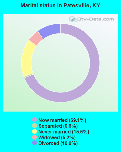
- Never married: 15.6%
- Now married: 69.1%
- Separated: 0.6%
- Widowed: 5.2%
- Divorced: 10.0%
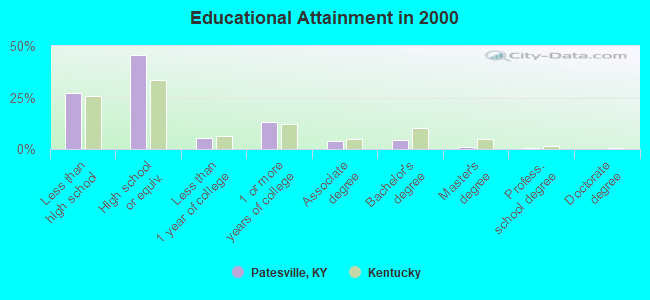
For population 25 years and over in Patesville:
- High school or higher: 73.0%
- Bachelor's degree or higher: 5.6%
- Graduate or professional degree: 1.1%
- Unemployed: 5.4%
- Mean travel time to work (commute): 30.0 minutes

| Here: | 10.8 |
| Kentucky average: | 13.8 |
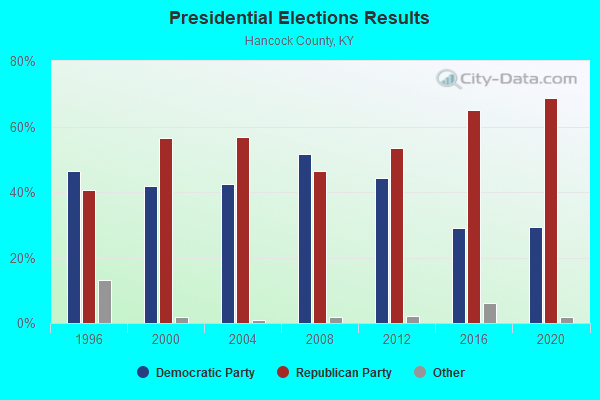
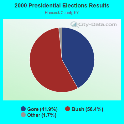
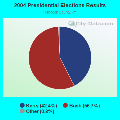
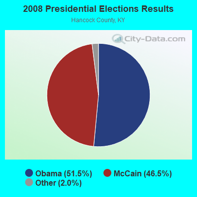
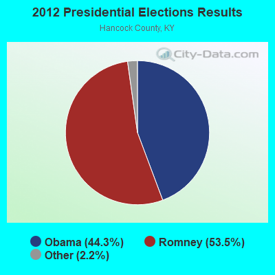
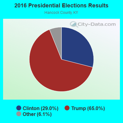

Graphs represent county-level data. Detailed 2008 Election Results
Religion statistics for Patesville, KY (based on Hancock County data)
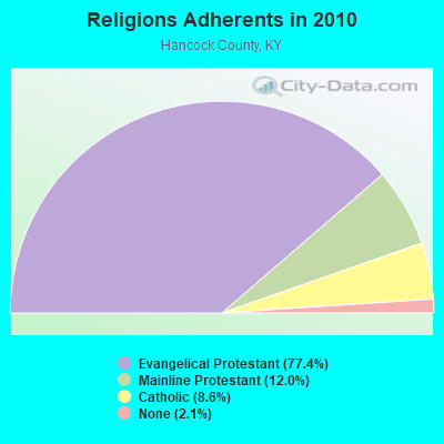
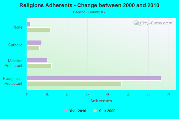
| Religion | Adherents | Congregations |
|---|---|---|
| Evangelical Protestant | 6,628 | 17 |
| Mainline Protestant | 1,027 | 6 |
| Catholic | 733 | 2 |
| None | 177 | - |
Food Environment Statistics:
| This county: | 2.33 / 10,000 pop. |
| Kentucky: | 2.19 / 10,000 pop. |
| Hancock County: | 5.83 / 10,000 pop. |
| State: | 4.36 / 10,000 pop. |
| Hancock County: | 5.83 / 10,000 pop. |
| Kentucky: | 5.74 / 10,000 pop. |
| Hancock County: | 10.7% |
| Kentucky: | 11.0% |
| Here: | 29.1% |
| Kentucky: | 30.0% |
| Here: | 16.1% |
| Kentucky: | 15.9% |
Strongest AM radio stations in Patesville:
- WKCM (1160 AM; 2 kW; HAWESVILLE, KY; Owner: HANCOCK COMMUNICATIONS, INC.)
- WHAS (840 AM; 50 kW; LOUISVILLE, KY; Owner: CLEAR CHANNEL BROADCASTING LICENSES, INC.)
- WVJS (1420 AM; 5 kW; OWENSBORO, KY; Owner: TSB III, LLC)
- WTCJ (1230 AM; 1 kW; TELL CITY, IN; Owner: HANCOCK COMMUNICATIONS, INC.)
- WSM (650 AM; 50 kW; NASHVILLE, TN; Owner: GAYLORD ENTERTAINMENT COMPANY)
- WKDA (1200 AM; 50 kW; NASHVILLE, TN; Owner: RADIO NASHVILLE, INC.)
- WAMB (1160 AM; 50 kW; DONELSON, TN; Owner: GREAT SOUTHERN BROADCASTING COMPANY, INC.)
- WNQM (1300 AM; 50 kW; NASHVILLE, TN; Owner: WNQM. INC.)
- WLAC (1510 AM; 50 kW; NASHVILLE, TN; Owner: CAPSTAR TX LIMITED PARTNERSHIP)
- WKJK (1080 AM; 10 kW; LOUISVILLE, KY; Owner: CLEAR CHANNEL BROADCASTING LICENSES, INC.)
- WLW (700 AM; 50 kW; CINCINNATI, OH; Owner: JACOR BROADCASTING CORPORATION)
- WGBF (1280 AM; 5 kW; EVANSVILLE, IN; Owner: CLEAR CHANNEL BROADCASTING LICENSES, INC.)
- WIBC (1070 AM; 50 kW; INDIANAPOLIS, IN; Owner: EMMIS RADIO LICENSE CORPORATION)
Strongest FM radio stations in Patesville:
- WTCJ-FM (105.7 FM; TELL CITY, IN; Owner: HANCOCK COMMUNICATIONS, INC.)
- WLME (102.9 FM; CANNELTON, IN; Owner: HANCOCK COMMUNICATIONS, INC)
- WBKR (92.5 FM; OWENSBORO, KY; Owner: REGENT BROADCASTING OF EVANSVILLE/OWENSBORO, INC.)
- WXCM (97.1 FM; HAWESVILLE, KY; Owner: WLME, INC.)
- WBIO (94.7 FM; PHILPOT, KY; Owner: THE CROMWELL GROUP, INC OF KENTUCKY)
- WSTO (96.1 FM; OWENSBORO, KY; Owner: TSB III, LLC)
- WXBC (104.3 FM; HARDINSBURG, KY; Owner: BRECKINRIDGE BROADCASTING CO., INC.)
- WNIN-FM (88.3 FM; EVANSVILLE, IN; Owner: TRI-STATE PUBLIC TELEPLEX, INC.)
- WULF (94.3 FM; HARDINSBURG, KY; Owner: SKYTOWER COMMUNICATIONS - 94.3, LLC)
- WYXY (107.1 FM; BOONVILLE, IN; Owner: BOONVILLE BROADCASTING CO., INC.)
- WGZB-FM (96.5 FM; CORYDON, IN; Owner: BLUE CHIP BROADCASTING LICENSES II, LTD.)
- WQKZ (98.5 FM; FERDINAND, IN; Owner: GEM COMMUNICATIONS LLP)
- WBDC (100.9 FM; HUNTINGBURG, IN; Owner: DUBOIS COUNTY BROADCASTING, INC.)
- WBFI (91.5 FM; MCDANIELS, KY; Owner: BETHEL FELLOWSHIP, INC.)
- W246AF (97.1 FM; OWENSBORO, KY; Owner: FM 90.1, INC.)
TV broadcast stations around Patesville:
- WNIN (Channel 9; EVANSVILLE, IN; Owner: TRI-STATE PUBLIC TELEPLEX, INC.)
- WTVW (Channel 7; EVANSVILLE, IN; Owner: QUORUM OF INDIANA LICENSE, LLC)
- W12BJ (Channel 12; OWENSBORO, KY; Owner: UNIVERSITY OF KENTUCKY)
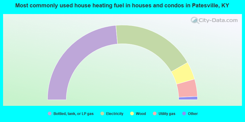
- 47.2%Bottled, tank, or LP gas
- 36.2%Electricity
- 7.7%Wood
- 7.5%Utility gas
- 0.7%Fuel oil, kerosene, etc.
- 0.6%Coal or coke
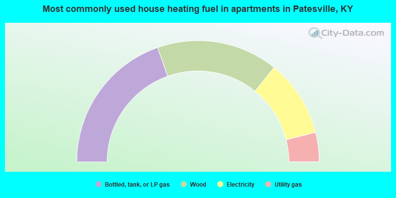
- 39.2%Bottled, tank, or LP gas
- 32.4%Wood
- 20.6%Electricity
- 7.8%Utility gas
Patesville compared to Kentucky state average:
- Median house value below state average.
- Unemployed percentage below state average.
- Black race population percentage significantly below state average.
- Hispanic race population percentage significantly below state average.
- Median age below state average.
- Foreign-born population percentage significantly below state average.
- Renting percentage below state average.
- Length of stay since moving in significantly above state average.
- Number of rooms per house significantly below state average.
- House age significantly below state average.
- Number of college students below state average.
- Percentage of population with a bachelor's degree or higher significantly below state average.