Cedar Grove, Tennessee

Cedar Grove: Tree covered in climbing vines
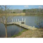
Cedar Grove: My resting place - Mr. Gilead Lake, Cedar Grove, TN 38321
- add
your
Submit your own pictures of this place and show them to the world
- OSM Map
- General Map
- Google Map
- MSN Map

| Males: 1,318 | |
| Females: 1,359 |
| Median resident age: | 39.5 years |
| Tennessee median age: | 35.9 years |
Zip code: 38321
| Cedar Grove: | $54,847 |
| TN: | $65,254 |
Estimated per capita income in 2022: $27,662 (it was $16,459 in 2000)
Cedar Grove CCD income, earnings, and wages data
Estimated median house or condo value in 2022: $121,427 (it was $49,100 in 2000)
| Cedar Grove: | $121,427 |
| TN: | $284,800 |
Detailed information about poverty and poor residents in Cedar Grove, TN


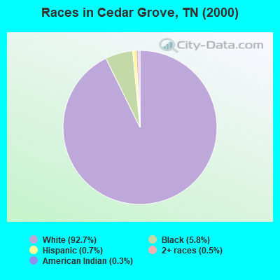
- 2,54292.7%White alone
- 1605.8%Black alone
- 180.7%Hispanic
- 130.5%Two or more races
- 70.3%American Indian alone
- 10.04%Asian alone
- 10.04%Native Hawaiian and Other
Pacific Islander alone
Races in Cedar Grove detailed stats: ancestries, foreign born residents, place of birth
According to our research of Tennessee and other state lists, there were 11 registered sex offenders living in Cedar Grove, Tennessee as of May 16, 2024.
The ratio of all residents to sex offenders in Cedar Grove is 243 to 1.
 Recent articles from our blog. Our writers, many of them Ph.D. graduates or candidates, create easy-to-read articles on a wide variety of topics.
Current Local Time: CST time zone
Land area: 115.4 square miles.
Population density: 23 people per square mile (very low).

| Cedar Grove CCD: | 0.6% ($288) |
| Tennessee: | 0.8% ($715) |
Nearest city with pop. 50,000+: Jackson, TN  (20.1 miles , pop. 59,643).
Nearest city with pop. 200,000+: Memphis, TN (93.0 miles , pop. 650,100).
Nearest city with pop. 1,000,000+: Chicago, IL (417.0 miles , pop. 2,896,016).
Nearest cities:
), ), ), ), ), ), )Latitude: 35.85 N, Longitude: 88.59 W
Area code: 731

| Here: | 3.7% |
| Tennessee: | 3.0% |
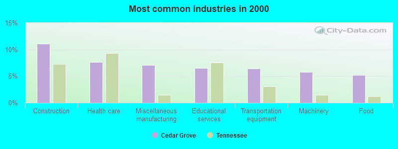
- Construction (11.1%)
- Health care (7.6%)
- Miscellaneous manufacturing (7.0%)
- Educational services (6.6%)
- Transportation equipment (6.5%)
- Machinery (5.8%)
- Food (5.2%)
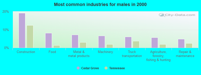
- Construction (19.2%)
- Food (8.2%)
- Metal & metal products (7.2%)
- Machinery (6.7%)
- Truck transportation (6.0%)
- Agriculture, forestry, fishing & hunting (5.7%)
- Repair & maintenance (4.8%)
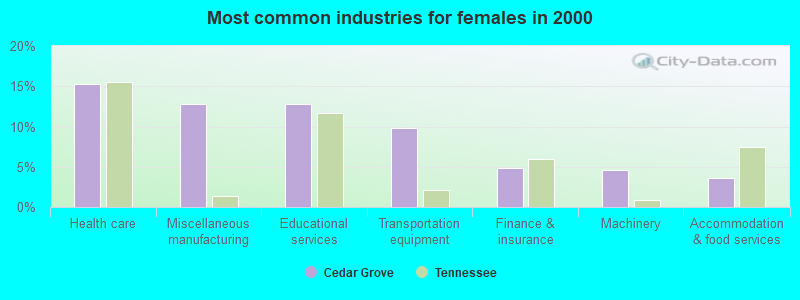
- Health care (15.3%)
- Miscellaneous manufacturing (12.8%)
- Educational services (12.8%)
- Transportation equipment (9.8%)
- Finance & insurance (4.8%)
- Machinery (4.6%)
- Accommodation & food services (3.7%)
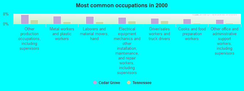
- Other production occupations, including supervisors (7.6%)
- Metal workers and plastic workers (6.4%)
- Laborers and material movers, hand (6.0%)
- Electrical equipment mechanics and other installation, maintenance, and repair workers, including supervisors (5.3%)
- Driver/sales workers and truck drivers (4.7%)
- Cooks and food preparation workers (4.1%)
- Other office and administrative support workers, including supervisors (3.7%)
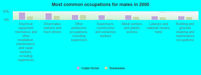
- Electrical equipment mechanics and other installation, maintenance, and repair workers, including supervisors (9.2%)
- Driver/sales workers and truck drivers (8.2%)
- Other production occupations, including supervisors (6.2%)
- Supervisors, construction and extraction workers (5.8%)
- Metal workers and plastic workers (5.7%)
- Laborers and material movers, hand (4.7%)
- Building and grounds cleaning and maintenance occupations (4.5%)

- Other production occupations, including supervisors (9.6%)
- Cooks and food preparation workers (8.4%)
- Laborers and material movers, hand (7.8%)
- Metal workers and plastic workers (7.3%)
- Other office and administrative support workers, including supervisors (6.2%)
- Registered nurses (5.5%)
- Health technologists and technicians (5.0%)
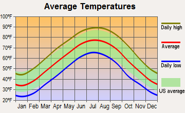
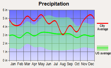
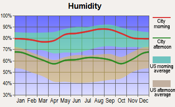
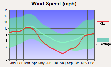
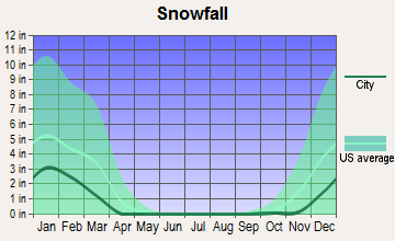
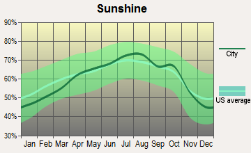
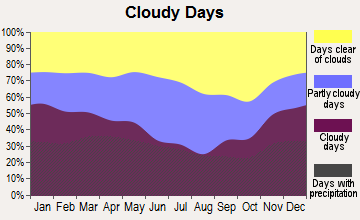
Average climate in Cedar Grove, Tennessee
Based on data reported by over 4,000 weather stations
(lower is better)
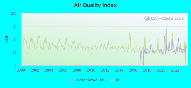
Air Quality Index (AQI) level in 2022 was 64.2. This is about average.
| City: | 64.2 |
| U.S.: | 72.6 |
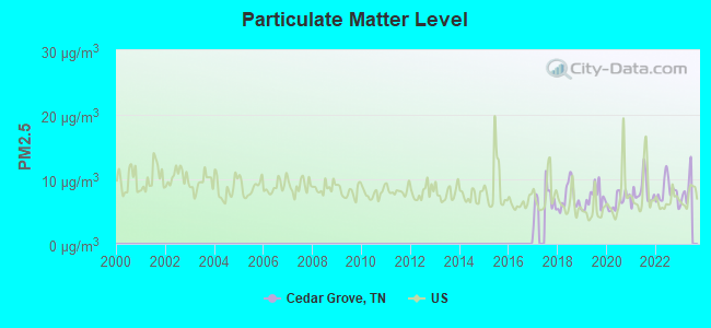
Particulate Matter (PM2.5) [µg/m3] level in 2022 was 8.18. This is about average. Closest monitor was 16.5 miles away from the city center.
| City: | 8.18 |
| U.S.: | 8.11 |
Tornado activity:
Cedar Grove-area historical tornado activity is slightly above Tennessee state average. It is 87% greater than the overall U.S. average.
On 1/17/1999, a category F4 (max. wind speeds 207-260 mph) tornado 16.3 miles away from the Cedar Grove place center killed 6 people and injured 106 people and caused $10 million in damages.
On 5/7/1971, a category F4 tornado 18.4 miles away from the place center killed 3 people and injured 137 people and caused between $500,000 and $5,000,000 in damages.
Earthquake activity:
Cedar Grove-area historical earthquake activity is significantly above Tennessee state average. It is 319% greater than the overall U.S. average.On 5/4/1991 at 01:18:54, a magnitude 5.0 (4.4 MB, 4.6 LG, 5.0 LG, Depth: 3.1 mi, Class: Moderate, Intensity: VI - VII) earthquake occurred 84.6 miles away from the city center
On 3/25/1976 at 00:41:20, a magnitude 5.0 (4.9 MB, 5.0 LG) earthquake occurred 98.7 miles away from Cedar Grove center
On 4/18/2008 at 09:36:59, a magnitude 5.4 (5.1 MB, 4.8 MS, 5.4 MW, 5.2 MW) earthquake occurred 183.8 miles away from the city center
On 9/26/1990 at 13:18:51, a magnitude 5.0 (4.7 MB, 4.8 LG, 5.0 LG, Depth: 7.7 mi) earthquake occurred 105.0 miles away from the city center
On 4/27/1989 at 16:47:49, a magnitude 4.7 (4.6 MB, 4.7 LG, 4.3 LG, Class: Light, Intensity: IV - V) earthquake occurred 66.9 miles away from the city center
On 4/18/2008 at 09:36:59, a magnitude 5.2 (5.2 MW, Depth: 8.9 mi) earthquake occurred 183.8 miles away from Cedar Grove center
Magnitude types: regional Lg-wave magnitude (LG), body-wave magnitude (MB), surface-wave magnitude (MS), moment magnitude (MW)
Natural disasters:
The number of natural disasters in Carroll County (17) is near the US average (15).Major Disasters (Presidential) Declared: 14
Emergencies Declared: 1
Causes of natural disasters: Storms: 12, Floods: 10, Tornadoes: 10, Winds: 6, Winter Storms: 2, Flash Flood: 1, Hurricane: 1, Ice Storm: 1, Other: 1 (Note: some incidents may be assigned to more than one category).
Hospitals and medical centers near Cedar Grove:
- NHC HEALTHCARE, MILAN (Nursing Home, about 10 miles away; MILAN, TN)
- MILAN GENERAL HOSPITAL Acute Care Hospitals (about 11 miles away; MILAN, TN)
- MILAN HEALTH CARE CENTER (Nursing Home, about 12 miles away; MILAN, TN)
- DOUGLAS NURSING HOME (Nursing Home, about 12 miles away; MILAN, TN)
- HILLHAVEN CONV CTR HUNTINGDON (Nursing Home, about 16 miles away; HUNTINGDON, TN)
- HUNTINGDON HEALTH AND REHAB CENTER (Nursing Home, about 16 miles away; HUNTINGDON, TN)
Colleges/universities with over 2000 students nearest to Cedar Grove:
- Jackson State Community College (about 19 miles; Jackson, TN; Full-time enrollment: 2,958)
- Union University (about 20 miles; Jackson, TN; FT enrollment: 4,051)
- Bethel University (about 21 miles; McKenzie, TN; FT enrollment: 5,878)
- The University of Tennessee-Martin (about 38 miles; Martin, TN; FT enrollment: 7,013)
- Dyersburg State Community College (about 47 miles; Dyersburg, TN; FT enrollment: 2,211)
- Murray State University (about 55 miles; Murray, KY; FT enrollment: 8,930)
- Northeast Mississippi Community College (about 83 miles; Booneville, MS; FT enrollment: 3,024)
Points of interest:
Notable locations in Cedar Grove: Carroll County Rural Fire Department District 5 Cedar Grove (A), Carroll County Rural Fire Department District 17 Terry (B). Display/hide their locations on the map
Churches in Cedar Grove include: Little Grove Church (A), Hickory Plains Church (B), Hickory Flat Church (C), Hopewell Baptist Church (D), Lavinia Methodist Church (E), Liberty Baptist Church (F), New Bethel Baptist Church (G), Pleasant Hill Church (H), Lavinia Baptist Church (I). Display/hide their locations on the map
Cemeteries: Wood Hill Cemetery (1), Woodard Cemetery (2), Little Grove Cemetery (3), Black Cemetery (4), Shiloh Cemetery (5), Pleasant Hill Cemetery (6), Palestine Cemetery (7). Display/hide their locations on the map
Lakes and reservoirs: Twin Lakes (A), Lake Site Number 86-2 (B), Indian Creek Lake Number 87-1 (C), Hoopers Lake (D), Donald Halters Lake (E), OFDBA 87-3 Lake (F), Moss Creek Lake (G). Display/hide their locations on the map
Streams, rivers, and creeks: Johns Creek (A), Indian Creek (B), Halls Branch (C), Griffin Creek (D), Grassy Hollow Creek (E), Gin Branch (F), Cat Creek (G), Cane Creek (H), Birch Branch (I). Display/hide their locations on the map
Drinking water stations with addresses in Cedar Grove and their reported violations in the past:
CEDAR GROVE UTILITY DISTRICT (Population served: 1,315, Groundwater):Past monitoring violations:
- Monitoring and Reporting (DBP) - Between OCT-2006 and DEC-2006, Contaminant: Chlorine. Follow-up actions: St Compliance achieved (JAN-01-2007), St Public Notif requested (FEB-01-2007), St Violation/Reminder Notice (FEB-01-2007)
- 37 regular monitoring violations
| This place: | 2.4 people |
| Tennessee: | 2.5 people |
| This place: | 65.4% |
| Whole state: | 69.8% |
| This place: | 3.3% |
| Whole state: | 4.2% |
Likely homosexual households (counted as self-reported same-sex unmarried-partner households)
- Lesbian couples: 0.1% of all households
- Gay men: 0.1% of all households
| This place: | 14.6% |
| Whole state: | 13.5% |
| This place: | 3.2% |
| Whole state: | 5.8% |
8 people in homes for the mentally retarded in 2000
For population 15 years and over in Cedar Grove:
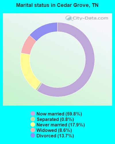
- Never married: 17.9%
- Now married: 59.8%
- Separated: 0.8%
- Widowed: 8.6%
- Divorced: 13.7%
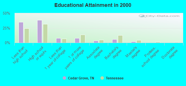
For population 25 years and over in Cedar Grove:
- High school or higher: 64.8%
- Bachelor's degree or higher: 7.9%
- Graduate or professional degree: 2.0%
- Unemployed: 15.4%
- Mean travel time to work (commute): 26.4 minutes
| Here: | 12.9 |
| Tennessee average: | 13.3 |
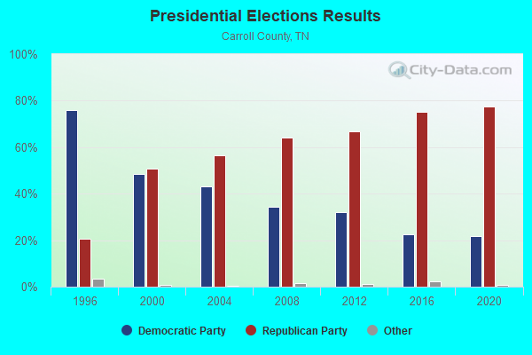
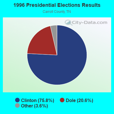
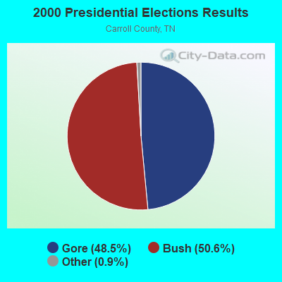
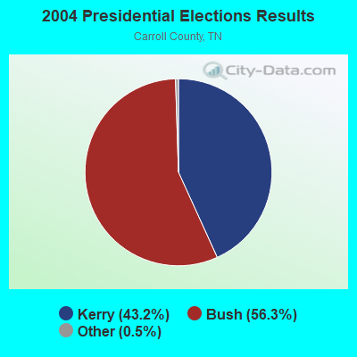
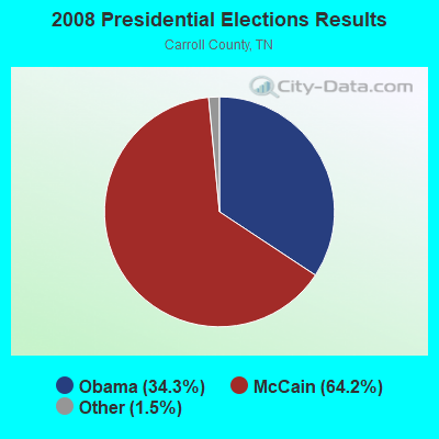
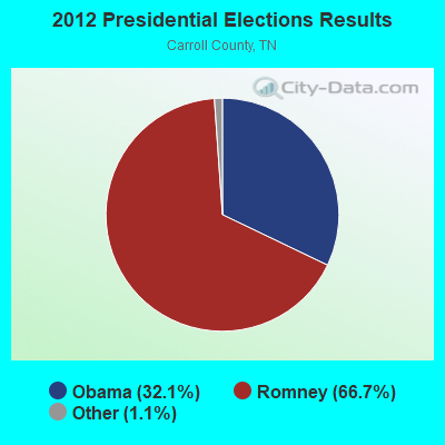
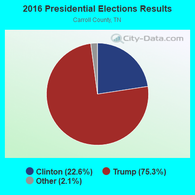
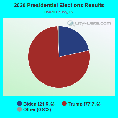
Graphs represent county-level data. Detailed 2008 Election Results
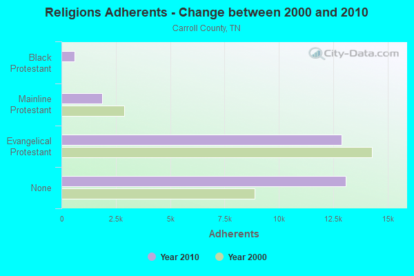
Religion statistics for Cedar Grove, TN (based on Carroll County data)
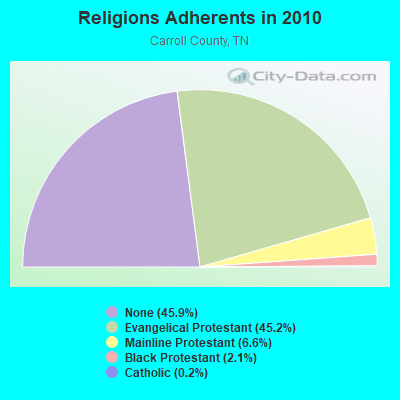
| Religion | Adherents | Congregations |
|---|---|---|
| Evangelical Protestant | 12,886 | 55 |
| Mainline Protestant | 1,883 | 21 |
| Black Protestant | 601 | 5 |
| Catholic | 69 | 1 |
| Other | 1 | - |
| None | 13,082 | - |
Food Environment Statistics:
| Here: | 2.77 / 10,000 pop. |
| Tennessee: | 1.99 / 10,000 pop. |
| This county: | 0.35 / 10,000 pop. |
| State: | 0.17 / 10,000 pop. |
| Carroll County: | 6.59 / 10,000 pop. |
| Tennessee: | 5.16 / 10,000 pop. |
| Carroll County: | 6.59 / 10,000 pop. |
| State: | 6.56 / 10,000 pop. |
| Carroll County: | 11.9% |
| Tennessee: | 11.4% |
| This county: | 29.0% |
| Tennessee: | 30.2% |
| This county: | 11.7% |
| Tennessee: | 13.5% |
Strongest AM radio stations in Cedar Grove:
- WDXI (1310 AM; 5 kW; JACKSON, TN; Owner: LIBERTY RADIO II, INC.)
- WTJS (1390 AM; 5 kW; JACKSON, TN; Owner: CAPSTAR TX LIMITED PARTNERSHIP)
- WCRV (640 AM; 50 kW; COLLIERVILLE, TN; Owner: BOTT BROADCASTING COMPANY/TENNESSEE)
- WSM (650 AM; 50 kW; NASHVILLE, TN; Owner: GAYLORD ENTERTAINMENT COMPANY)
- WGSF (1030 AM; 50 kW; MEMPHIS, TN; Owner: FLINN BROADCASTING CORPORATION)
- WDIA (1070 AM; 50 kW; MEMPHIS, TN; Owner: CLEAR CHANNEL BROADCASTING LICENSES, INC.)
- WMQM (1600 AM; 50 kW; LAKELAND, TN; Owner: WMQM, INC.)
- WKDA (1200 AM; 50 kW; NASHVILLE, TN; Owner: RADIO NASHVILLE, INC.)
- WNQM (1300 AM; 50 kW; NASHVILLE, TN; Owner: WNQM. INC.)
- WMUF (1000 AM; daytime; 5 kW; PARIS, TN; Owner: BENTON-WEATHERFORD B/CTING OF TN,INC)
- WAMB (1160 AM; 50 kW; DONELSON, TN; Owner: GREAT SOUTHERN BROADCASTING COMPANY, INC.)
- WDAP (1530 AM; daytime; 1 kW; HUNTINGDON, TN; Owner: MARK C. JOHNSON)
- WLAC (1510 AM; 50 kW; NASHVILLE, TN; Owner: CAPSTAR TX LIMITED PARTNERSHIP)
Strongest FM radio stations in Cedar Grove:
- WYNU (92.3 FM; MILAN, TN; Owner: CAPSTAR TX LIMITED PARTNERSHIP)
- WWYN (106.9 FM; MCKENZIE, TN; Owner: RAINBOW MEDIA, INC.)
- WIGH (88.7 FM; LEXINGTON, TN; Owner: AMERICAN FAMILY ASSOCIATION)
- WVHR (100.9 FM; HUNTINGDON, TN; Owner: MILAN BROADCASTING COMPANY, INC.)
- WTKB-FM (93.7 FM; ATWOOD, TN; Owner: GIBSON COUNTY BROADCASTING COMPANY, INC.)
- WTNV (104.1 FM; JACKSON, TN; Owner: CAPSTAR TX LIMITED PARTNERSHIP)
- WBFG (96.5 FM; PARKER'S CROSSROADS, TN; Owner: CROSSROADS BROADCASTING, LLC)
- WKNP (90.1 FM; JACKSON, TN; Owner: MID-SOUTH PUBLIC COMMUNICTNS FOUNDTN)
- WLSZ (105.3 FM; HUMBOLDT, TN; Owner: BOYD ENTERPRISES, INC.)
- WNWS-FM (101.5 FM; JACKSON, TN; Owner: RADIOCORP OF JACKSON, INC.)
- WMXX-FM (103.1 FM; JACKSON, TN; Owner: GERALD W. HUNT)
- WZDQ (102.3 FM; HUMBOLDT, TN; Owner: THOMAS RADIO, LLC)
- WAJJ (89.3 FM; MCKENZIE, TN; Owner: HEARTLAND MINSTRIES, INC.)
- WMUF-FM (104.7 FM; HENRY, TN; Owner: BENTON WEATHERFORD B/C INC OF TN)
- W256AD (99.1 FM; MILAN, TN; Owner: AMERICAN FAMILY ASSOCIATION)
- WHHM-FM (107.7 FM; HENDERSON, TN; Owner: THOMAS RADIO, LLC)
- WWGM (93.1 FM; ALAMO, TN; Owner: GRACE BROADCASTING SERVICES, INC.)
- WTNE-FM (97.7 FM; TRENTON, TN; Owner: GIBSON COUNTY BROADCASTING COMPANY, INC.)
TV broadcast stations around Cedar Grove:
- WBBJ-TV (Channel 7; JACKSON, TN; Owner: TENNESSEE BROADCASTING PARTNERS)
- WLJT (Channel 11; LEXINGTON, TN; Owner: WEST TENNESSEE PUBLIC TV COUNCIL, INC)
- W26CJ (Channel 26; JACKSON, TN; Owner: MS COMMUNICATIONS, LLC)
- WJTE-LP (Channel 19; JACKSON, TN; Owner: TIGER EYE BROADCASTING CORPORATION)
- W22BR (Channel 22; JACKSON, TN; Owner: MS COMMUNICATIONS, LLC)
- W52CZ (Channel 52; JACKSON, TN; Owner: MS COMMUNICATIONS, LLC)
- W64BZ (Channel 64; JACKSON, TN; Owner: MS COMMUNICATIONS, LLC)
- WJKT (Channel 16; JACKSON, TN; Owner: CLEAR CHANNEL BROADCASTING LICENSES, INC.)
- W25BY (Channel 25; JACKSON, TN; Owner: MS COMMUNICATIONS, LLC)
- W38BY (Channel 38; JACKSON, TN; Owner: MS COMMUNICATIONS, LLC)
- W54BU (Channel 54; JACKSON, TN; Owner: MS COMMUNICATIONS, LLC)
- W35AH (Channel 35; JACKSON, TN; Owner: TRINITY BROADCASTING NETWORK)
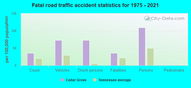
Cedar Grove fatal accident list:
FCC Registered Cell Phone Towers:
1 (See the full list of FCC Registered Cell Phone Towers in Cedar Grove)FCC Registered Antenna Towers:
56 (See the full list of FCC Registered Antenna Towers)FCC Registered Broadcast Land Mobile Towers:
2- 400 Summit Chase (Lat: 35.770972 Lon: -88.494528), Call Sign: WPWQ682,
Assigned Frequencies: 461.337 MHz, 457.537 MHz, 461.537 MHz, 461.512 MHz, 457.562 MHz, Grant Date: 01/07/2003, Expiration Date: 01/07/2013, Cancellation Date: 04/03/2007, Certifier: Robert Yurich, Registrant: Prolink Solutions, 410 S. Benson Lane, Chandler, AZ 85224, Phone: (480) 961-8800, Fax: (480) 961-2009, Email:
- Lat: 35.780194 Lon: -88.491833, Call Sign: WQJM549,
Assigned Frequencies: 462.212 MHz, 462.437 MHz, 467.212 MHz, 467.437 MHz, Grant Date: 11/04/2008, Expiration Date: 11/04/2018, Cancellation Date: 02/16/2019, Certifier: Dave Gremmels, Registrant: Cara Enterprises Inc, Salt Lake City, UT 84117-0503, Phone: (801) 278-9728, Fax: (801) 278-7239, Email:
FCC Registered Microwave Towers:
10 (See the full list of FCC Registered Microwave Towers in this town)FCC Registered Amateur Radio Licenses:
22 (See the full list of FCC Registered Amateur Radio Licenses in Cedar Grove)FAA Registered Aircraft:
6- Aircraft: JONES DA/JONES VA RV10 (Category: Land, Seats: 4, Weight: Up to 12,499 Pounds), Engine: MATTITUCK TMX-540 (250 HP) (Reciprocating)
N-Number: 143DV, N143DV, N-143DV, Serial Number: 40026, Year manufactured: 2007, Airworthiness Date: 05/04/2007, Certificate Issue Date: 01/19/2007
Registrant (Co-Owned): David A Jones, 7135 Highway 424, Cedar Grove, TN 38321, Other Owners: Vicki A Jones - Aircraft: PIPER PA-22-150 (Category: Land, Seats: 4, Weight: Up to 12,499 Pounds, Speed: 94 mph), Engine: LYCOMING 0-320 SERIES (180 HP) (Reciprocating)
N-Number: 2912Z, N2912Z, N-2912Z, Serial Number: 22-6882, Year manufactured: 1959, Airworthiness Date: 09/05/1990, Certificate Issue Date: 09/17/2015
Registrant (Individual): Charles D Ford, 2290 Water Tower Rd, Cedar Grove, TN 38321 - Aircraft: PIPER PA-24-250 (Category: Land, Seats: 4, Weight: Up to 12,499 Pounds, Speed: 135 mph), Engine: LYCOMING 0-540 SERIES (250 HP) (Reciprocating)
N-Number: 500P, N500P, N-500P, Serial Number: 24-341, Airworthiness Date: 11/08/1991, Certificate Issue Date: 04/30/2014
Registrant (Individual): Charles D Ford, 2290 Water Tower Rd, Cedar Grove, TN 38321 - Aircraft: BUCKEYE DREAM MACHINE (Category: Land, Seats: 2, Weight: Up to 12,499 Pounds), Engine: ROTAX 582SER (65 HP) (2 Cycle)
N-Number: 536MC, N536MC, N-536MC, Serial Number: 6217, Year manufactured: 2003, Airworthiness Date: 12/22/2007, Certificate Issue Date: 12/07/2007
Registrant (Individual): Michael S Corrigan, 400 Summit Chase Rd, Cedar Grove, TN 38321 - Aircraft: PIPER PA-28-180 (Category: Land, Seats: 4, Weight: Up to 12,499 Pounds, Speed: 107 mph), Engine: LYCOMING O&VO-360 SER (180 HP) (Reciprocating)
N-Number: 7723N, N7723N, N-7723N, Serial Number: 28-5166, Year manufactured: 1968, Airworthiness Date: 10/10/1968, Certificate Issue Date: 02/25/2014
Registrant (Individual): Charles D Ford, 2290 Water Tower Rd, Cedar Grove, TN 38321 - Aircraft: DESTINY DESTINY (Category: Land, Seats: 2, Weight: Up to 12,499 Pounds), Engine: ROTAX 582SER (65 HP) (2 Cycle)
N-Number: 836KB, N836KB, N-836KB, Serial Number: 4C/571, Year manufactured: 2004, Airworthiness Date: 12/22/2007, Certificate Issue Date: 12/11/2007
Registrant (Individual): Michael S Corrigan, 400 Summit Chase Rd, Cedar Grove, TN 38321
2003 - 2018 National Fire Incident Reporting System (NFIRS) incidents
- Fire incident types reported to NFIRS in Cedar Grove, TN
- 12345.2%Outside Fires
- 10438.2%Structure Fires
- 4115.1%Mobile Property/Vehicle Fires
- 41.5%Other
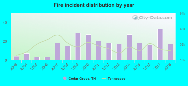 Based on the data from the years 2003 - 2018 the average number of fires per year is 17. The highest number of fires - 33 took place in 2017, and the least - 3 in 2005. The data has a growing trend.
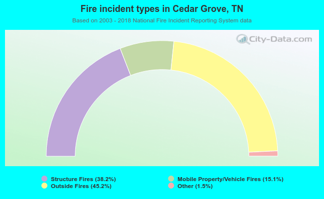 When looking into fire subcategories, the most reports belonged to: Outside Fires (45.2%), and Structure Fires (38.2%).
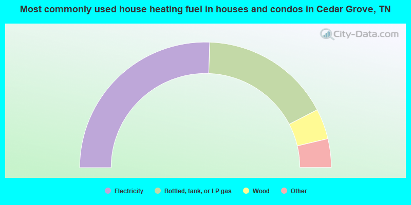
- 51.1%Electricity
- 33.7%Bottled, tank, or LP gas
- 7.8%Wood
- 2.9%Utility gas
- 2.4%Other fuel
- 1.5%Fuel oil, kerosene, etc.
- 0.6%No fuel used
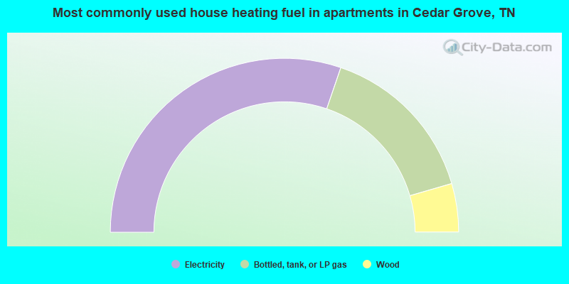
- 60.5%Electricity
- 30.5%Bottled, tank, or LP gas
- 9.0%Wood
Cedar Grove compared to Tennessee state average:
- Median house value significantly below state average.
- Black race population percentage below state average.
- Hispanic race population percentage significantly below state average.
- Foreign-born population percentage significantly below state average.
- Renting percentage significantly below state average.
- Length of stay since moving in significantly above state average.
- Number of rooms per house significantly below state average.
- House age significantly below state average.
- Percentage of population with a bachelor's degree or higher significantly below state average.

|
Total of 13 patent applications in 2008-2024.