Colton, Oregon


Submit your own pictures of this place and show them to the world
- OSM Map
- General Map
- Google Map
- MSN Map
| Males: 2,786 | |
| Females: 2,771 |
| Median resident age: | 37.6 years |
| Oregon median age: | 36.3 years |
Zip code: 97017
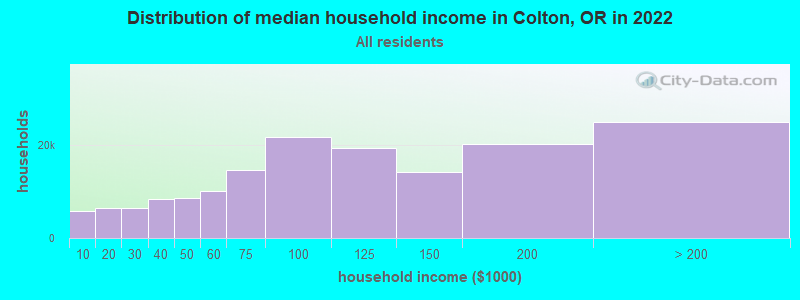
| Colton: | $95,580 |
| OR: | $75,657 |
Estimated per capita income in 2022: $40,463 (it was $20,612 in 2000)
Colton CCD income, earnings, and wages data
Estimated median house or condo value in 2022: $642,110 (it was $202,700 in 2000)
| Colton: | $642,110 |
| OR: | $475,600 |
Mean prices in 2022: all housing units: $668,506; detached houses: $712,780; townhouses or other attached units: $545,138; in 2-unit structures: $353,490; in 3-to-4-unit structures: $395,250; in 5-or-more-unit structures: $386,249; mobile homes: $236,979; occupied boats, rvs, vans, etc.: $105,736
Detailed information about poverty and poor residents in Colton, OR


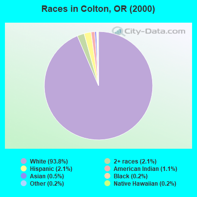
- 4,71293.8%White alone
- 1032.1%Two or more races
- 1032.1%Hispanic
- 541.1%American Indian alone
- 230.5%Asian alone
- 120.2%Black alone
- 80.2%Native Hawaiian and Other
Pacific Islander alone - 90.2%Other race alone
Races in Colton detailed stats: ancestries, foreign born residents, place of birth
 Recent articles from our blog. Our writers, many of them Ph.D. graduates or candidates, create easy-to-read articles on a wide variety of topics.
Current Local Time: PST time zone
Elevation: 707 feet
Land area: 105.5 square miles.
Population density: 53 people per square mile (very low).
| Colton CCD: | 0.8% ($1,540) |
| Oregon: | 1.2% ($1,687) |
Nearest city with pop. 50,000+: Northwest Clackamas, OR (19.6 miles  , pop. 224,220).
Nearest city with pop. 1,000,000+: Los Angeles, CA (795.0 miles , pop. 3,694,820).
Nearest cities:
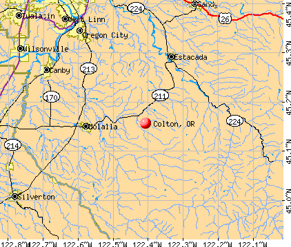
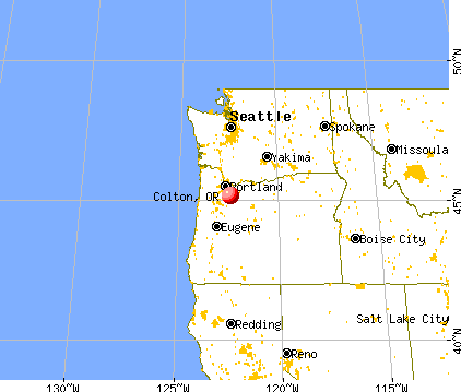
), ), ), ), Latitude: 45.16 N, Longitude: 122.41 W
Area code: 503

| Here: | 3.4% |
| Oregon: | 3.9% |
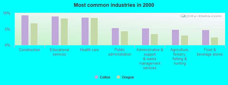
- Construction (9.3%)
- Educational services (9.0%)
- Health care (8.7%)
- Public administration (5.4%)
- Administrative & support & waste management services (5.3%)
- Agriculture, forestry, fishing & hunting (4.9%)
- Food & beverage stores (4.8%)
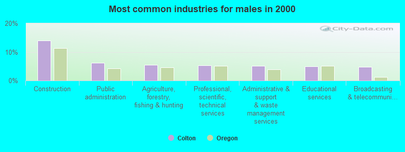
- Construction (13.9%)
- Public administration (6.3%)
- Agriculture, forestry, fishing & hunting (5.5%)
- Professional, scientific, technical services (5.3%)
- Administrative & support & waste management services (5.1%)
- Educational services (5.0%)
- Broadcasting & telecommunications (4.7%)
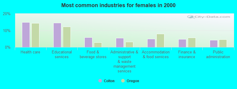
- Health care (14.9%)
- Educational services (14.5%)
- Food & beverage stores (5.9%)
- Administrative & support & waste management services (5.5%)
- Accommodation & food services (5.0%)
- Finance & insurance (4.8%)
- Public administration (4.2%)
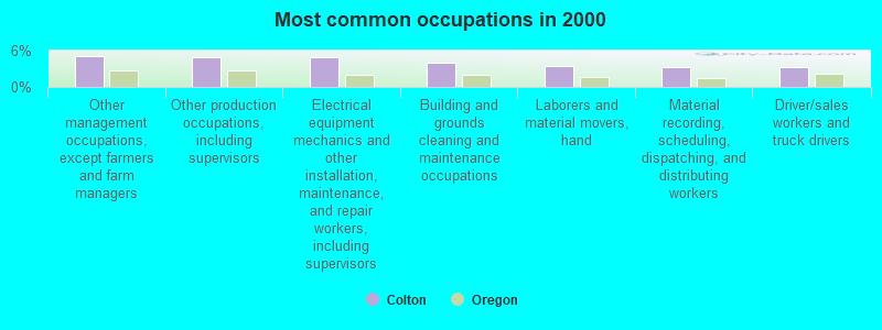
- Other management occupations, except farmers and farm managers (5.0%)
- Other production occupations, including supervisors (4.9%)
- Electrical equipment mechanics and other installation, maintenance, and repair workers, including supervisors (4.9%)
- Building and grounds cleaning and maintenance occupations (4.0%)
- Laborers and material movers, hand (3.4%)
- Material recording, scheduling, dispatching, and distributing workers (3.3%)
- Driver/sales workers and truck drivers (3.3%)
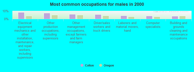
- Electrical equipment mechanics and other installation, maintenance, and repair workers, including supervisors (8.5%)
- Other production occupations, including supervisors (7.4%)
- Other management occupations, except farmers and farm managers (6.0%)
- Driver/sales workers and truck drivers (5.7%)
- Laborers and material movers, hand (4.4%)
- Computer specialists (3.8%)
- Building and grounds cleaning and maintenance occupations (3.5%)
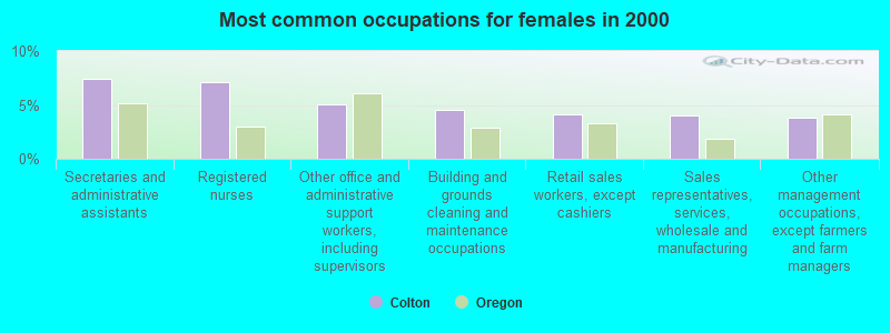
- Secretaries and administrative assistants (7.4%)
- Registered nurses (7.1%)
- Other office and administrative support workers, including supervisors (5.1%)
- Building and grounds cleaning and maintenance occupations (4.6%)
- Retail sales workers, except cashiers (4.1%)
- Sales representatives, services, wholesale and manufacturing (4.0%)
- Other management occupations, except farmers and farm managers (3.8%)
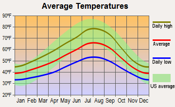
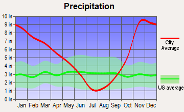
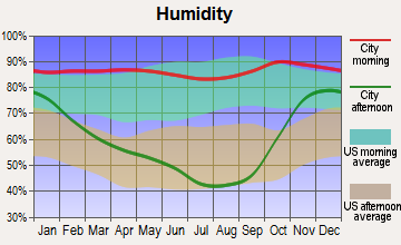
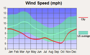
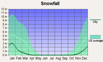
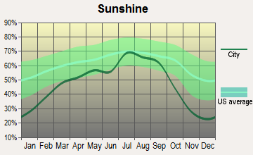
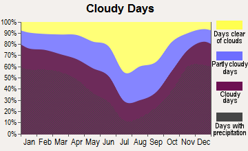
Average climate in Colton, Oregon
Based on data reported by over 4,000 weather stations
(lower is better)
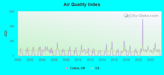
Air Quality Index (AQI) level in 2023 was 68.2. This is about average.
| City: | 68.2 |
| U.S.: | 72.6 |
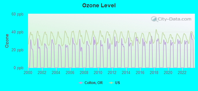
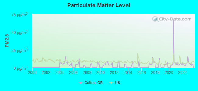
Particulate Matter (PM2.5) [µg/m3] level in 2023 was 4.60. This is significantly better than average. Closest monitor was 19.3 miles away from the city center.
| City: | 4.60 |
| U.S.: | 8.11 |
Earthquake activity:
Colton-area historical earthquake activity is significantly above Oregon state average. It is 1460% greater than the overall U.S. average.On 4/13/1949 at 19:55:42, a magnitude 7.0 (7.0 UK, Class: Major, Intensity: VIII - XII) earthquake occurred 144.9 miles away from the city center, causing $80,000,000 total damage
On 2/28/2001 at 18:54:32, a magnitude 6.8 (6.5 MB, 6.6 MS, 6.8 MW, Class: Strong, Intensity: VII - IX) earthquake occurred 134.0 miles away from the city center, causing $2,000,000,000 total damage and $305,000,000 insured losses
On 2/28/2001 at 18:54:32, a magnitude 6.8 (6.8 MD, Depth: 32.2 mi) earthquake occurred 138.7 miles away from the city center
On 1/31/1922 at 13:17:28, a magnitude 7.6 (7.6 UK) earthquake occurred 346.9 miles away from the city center
On 4/29/1965 at 15:28:43, a magnitude 6.6 (6.6 UK) earthquake occurred 149.5 miles away from Colton center, causing $28,000,000 total damage
On 11/8/1980 at 10:27:34, a magnitude 7.2 (6.2 MB, 7.2 MS, 7.2 MW, 7.0 ML) earthquake occurred 295.7 miles away from Colton center
Magnitude types: body-wave magnitude (MB), duration magnitude (MD), local magnitude (ML), surface-wave magnitude (MS), moment magnitude (MW)
Natural disasters:
The number of natural disasters in Clackamas County (13) is near the US average (15).Major Disasters (Presidential) Declared: 11
Emergencies Declared: 1
Causes of natural disasters: Floods: 7, Landslides: 4, Mudslides: 4, Storms: 4, Winter Storms: 4, Snows: 2, Winds: 2, Earthquake: 1, Fire: 1, Heavy Rain: 1, Hurricane: 1, Other: 1 (Note: some incidents may be assigned to more than one category).
Hospitals and medical centers in Colton:
Other hospitals and medical centers near Colton:
- MOLALLA MANOR CARE CENTER (Nursing Home, about 9 miles away; MOLALLA, OR)
- MARQUIS CARE AT OREGON CITY (Nursing Home, about 16 miles away; OREGON CITY, OR)
- MARQUIS CARE AT HOPE VILLAGE (Nursing Home, about 16 miles away; CANBY, OR)
- PERCEPTION CARE CENTER INC (Nursing Home, about 16 miles away; CANBY, OR)
- OREGON CITY HEALTH CARE CENTER (Nursing Home, about 16 miles away; OREGON CITY, OR)
Colleges/universities with over 2000 students nearest to Colton:
- Clackamas Community College (about 15 miles; Oregon City, OR; Full-time enrollment: 4,261)
- Pioneer Pacific College (about 21 miles; Wilsonville, OR; FT enrollment: 2,194)
- Lewis & Clark College (about 25 miles; Portland, OR; FT enrollment: 2,864)
- Mt Hood Community College (about 25 miles; Gresham, OR; FT enrollment: 11,847)
- Portland Community College (about 26 miles; Portland, OR; FT enrollment: 23,600)
- Portland State University (about 28 miles; Portland, OR; FT enrollment: 21,450)
- George Fox University (about 30 miles; Newberg, OR; FT enrollment: 2,954)
Public high school in Colton:
- COLTON HIGH SCHOOL (Students: 238, Location: 30205 S WALL ST, Grades: 9-12)
Public elementary/middle schools in Colton:
- COLTON ELEMENTARY SCHOOL (Students: 283, Location: 30439 S GRAYS HILL RD, Grades: KG-5)
- COLTON MIDDLE SCHOOL (Students: 198, Location: 21580 S SCHIEFFER RD, Grades: 6-8)
Points of interest:
Notable locations in Colton: Hillockburn Guard Station (A), Feyrer Park Boat Ramp (B), Four Corners (C), Dickey Prairie (D), Camp Colton (E), Camp Adams (F), North Fork Ranger Station (G), Colton Rural Fire Protection District 70 Main Station (H), Colton Rural Fire Protection District 70 Station 123 (I). Display/hide their locations on the map
Churches in Colton include: Colton Evangelical Lutheran Church (A), Colton Community Church (B), Aspen Meadow Church (C), The Country Christian Church (D). Display/hide their locations on the map
Cemeteries: Elwood Cemetery (1), Bonney Cemetery (2), Colton Lutheran Cemetery (3). Display/hide their locations on the map
Lakes and reservoirs: Cedar Grove Lake (A), Clear Lake (B), Karney Reservoir (C), Swanson Reservoir (D). Display/hide their locations on the map
Creeks: Jackson Creek (A), Dorn Creek (B), Canyon Creek (C), Bittner Creek (D), Bee Creek (E), Alder Creek (F), Bull Creek (G), Mill Creek (H), Hancock Creek (I). Display/hide their locations on the map
Drinking water stations with addresses in Colton and their reported violations in the past:
COLTON WATER DISTRICT (Population served: 1,500, Surface water):Past health violations:Past monitoring violations:
- MCL, Monthly (TCR) - In JUL-2008, Contaminant: Coliform. Follow-up actions: St Compliance achieved (SEP-02-2008)
- Monitoring and Reporting (DBP) - Between JAN-2014 and MAR-2014, Contaminant: TTHM. Follow-up actions: St Compliance achieved (MAY-13-2014)
- Monitoring and Reporting (DBP) - Between JAN-2014 and MAR-2014, Contaminant: Total Haloacetic Acids (HAA5). Follow-up actions: St Compliance achieved (MAY-13-2014)
- Monitoring and Reporting (DBP) - Between OCT-2013 and DEC-2013, Contaminant: Total Haloacetic Acids (HAA5). Follow-up actions: St Compliance achieved (MAY-13-2014)
- Monitoring and Reporting (DBP) - Between OCT-2013 and DEC-2013, Contaminant: TTHM. Follow-up actions: St Compliance achieved (MAY-13-2014)
- Monitoring, Turbidity (Enhanced SWTR) - In FEB-2013, Contaminant: IESWTR. Follow-up actions: St Compliance achieved (APR-04-2013)
- 3 routine major monitoring violations
- One minor monitoring violation
- 117 regular monitoring violations
- 22 other older monitoring violations
| This place: | 2.8 people |
| Oregon: | 2.5 people |
| This place: | 77.8% |
| Whole state: | 63.4% |
| This place: | 6.3% |
| Whole state: | 8.0% |
Likely homosexual households (counted as self-reported same-sex unmarried-partner households)
- Lesbian couples: 0.3% of all households
- Gay men: 0.4% of all households
| This place: | 9.0% |
| Whole state: | 11.6% |
| This place: | 5.2% |
| Whole state: | 5.0% |
For population 15 years and over in Colton:
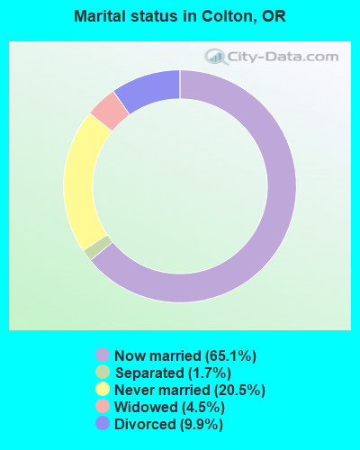
- Never married: 20.5%
- Now married: 65.1%
- Separated: 1.7%
- Widowed: 4.5%
- Divorced: 9.9%
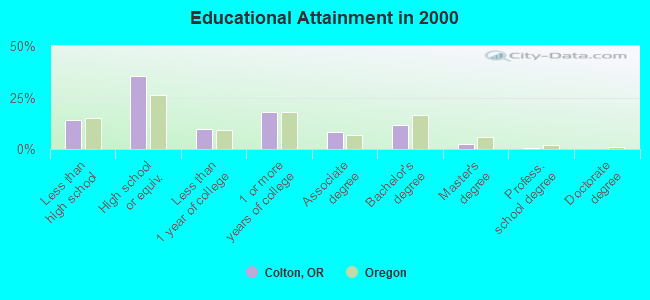
For population 25 years and over in Colton:
- High school or higher: 85.8%
- Bachelor's degree or higher: 14.5%
- Graduate or professional degree: 2.7%
- Unemployed: 5.9%
- Mean travel time to work (commute): 34.2 minutes
| Here: | 8.2 |
| Oregon average: | 11.5 |
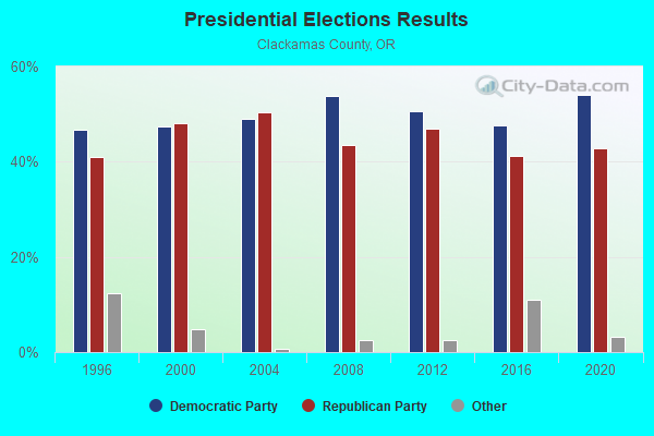
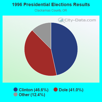
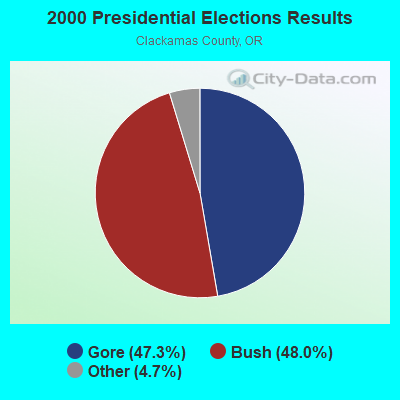
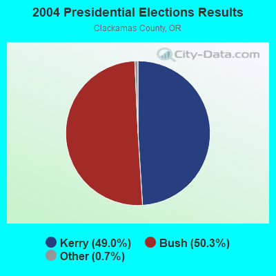

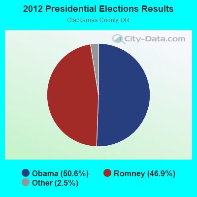
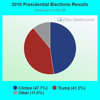
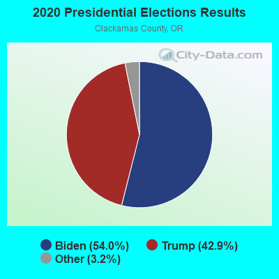
Graphs represent county-level data. Detailed 2008 Election Results
Religion statistics for Colton, OR (based on Clackamas County data)
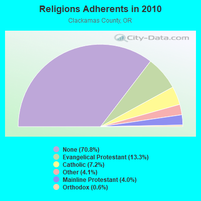
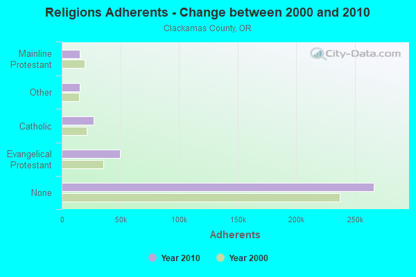
| Religion | Adherents | Congregations |
|---|---|---|
| Evangelical Protestant | 49,829 | 194 |
| Catholic | 27,128 | 13 |
| Other | 15,447 | 51 |
| Mainline Protestant | 15,118 | 49 |
| Orthodox | 2,275 | 5 |
| None | 266,195 | - |
Food Environment Statistics:
| Clackamas County: | 1.49 / 10,000 pop. |
| Oregon: | 2.03 / 10,000 pop. |
| This county: | 0.27 / 10,000 pop. |
| Oregon: | 0.33 / 10,000 pop. |
| This county: | 1.47 / 10,000 pop. |
| Oregon: | 2.01 / 10,000 pop. |
| Clackamas County: | 1.57 / 10,000 pop. |
| Oregon: | 1.69 / 10,000 pop. |
| Clackamas County: | 7.57 / 10,000 pop. |
| State: | 9.93 / 10,000 pop. |
| Clackamas County: | 6.9% |
| Oregon: | 7.4% |
| Clackamas County: | 25.7% |
| Oregon: | 25.6% |
| This county: | 13.5% |
| Oregon: | 14.2% |
9.10% of this county's 2021 resident taxpayers lived in other counties in 2020 ($99,084 average adjusted gross income)
| Here: | 9.10% |
| Oregon average: | 8.20% |
0.01% of residents moved from foreign countries ($71 average AGI)
Clackamas County: 0.01% Oregon average: 0.01%
Top counties from which taxpayers relocated into this county between 2020 and 2021:
| from Multnomah County, OR | |
| from Washington County, OR | |
| from Marion County, OR |
Strongest AM radio stations in Colton:
- KXL (750 AM; 50 kW; PORTLAND, OR; Owner: ROSE CITY RADIO CORPORATION)
- KPOJ (620 AM; 50 kW; PORTLAND, OR; Owner: CITICASTERS LICENSES, L.P.)
- KEX (1190 AM; 50 kW; PORTLAND, OR; Owner: CITICASTERS LICENSES, L.P.)
- KKSN (1520 AM; 50 kW; OREGON CITY, OR; Owner: ENTERCOM PORTLAND LICENSE, LLC)
- KOTK (1080 AM; 50 kW; PORTLAND, OR; Owner: FISHER BROADCASTING - PORTLAND RADIO, L.L.C.)
- KPAM (860 AM; 50 kW; TROUTDALE, OR; Owner: PAMPLIN BROADCASTING-OREGON, INC.)
- KKAD (1550 AM; 50 kW; VANCOUVER, WA; Owner: PAMPLIN BROADCASTING-WASHINGTON, INC)
- KKSL (1290 AM; 10 kW; LAKE OSWEGO, OR; Owner: ABC, INC.)
- KFXX (910 AM; 10 kW; VANCOUVER, WA; Owner: ENTERCOM PORTLAND LICENSE, LLC (DE))
- KDZR (1640 AM; 10 kW; LAKE OSWEGO, OR; Owner: ABC, INC.)
- KGUY (1010 AM; daytime; 4 kW; MILWAUKIE, OR; Owner: NORTHWEST RADIO BROADCASTING COMPANY)
- KKPZ (1330 AM; 5 kW; PORTLAND, OR; Owner: KPHP RADIO, INC.)
- KSLM (1390 AM; 10 kW; SALEM, OR)
Strongest FM radio stations in Colton:
- K273AJ (102.5 FM; ELWOOD, OR; Owner: CALVARY CHAPEL OF TWIN FALLS, INC.)
- KRSK (105.1 FM; MOLALLA, OR; Owner: ENTERCOM PORTLAND LICENSE, LLC)
- KINK (101.9 FM; PORTLAND, OR; Owner: INFINITY RADIO OPERATIONS INC.)
- KKCW (103.3 FM; BEAVERTON, OR; Owner: CITICASTERS LICENSES, L.P.)
- KOPB-FM (91.5 FM; PORTLAND, OR; Owner: OREGON PUBLIC BROADCASTING)
- KPDQ-FM (93.7 FM; PORTLAND, OR; Owner: SALEM MEDIA OF OREGON, INC.)
- KNRK (94.7 FM; CAMAS, WA; Owner: ENTERCOM PORTLAND LICENSE, LLC (DE))
- KKRZ (100.3 FM; PORTLAND, OR; Owner: CITICASTERS LICENSES, L.P.)
- KUFO-FM (101.1 FM; PORTLAND, OR; Owner: INFINITY RADIO OPERATIONS INC.)
- KMHD (89.1 FM; GRESHAM, OR; Owner: MT. HOOD COMMUNITY COLLEGE DISTRICT)
- KVMX (107.5 FM; BANKS, OR; Owner: INFINITY RADIO OPERATIONS INC.)
- KLTH (106.7 FM; LAKE OSWEGO, OR; Owner: INIFINITY RADIO OF PORTLAND INC.)
- KUPL-FM (98.7 FM; PORTLAND, OR; Owner: INFINITY RADIO OF PORTLAND INC.)
- KGON (92.3 FM; PORTLAND, OR; Owner: ENTERCOM PORTLAND LICENSE, LLC (DE))
- KKSN-FM (97.1 FM; PORTLAND, OR; Owner: ENTERCOM PORTLAND LICENSE, LLC (DE))
- KXJM (95.5 FM; PORTLAND, OR; Owner: ROSE CITY RADIO CORPORATION)
- KBOO (90.7 FM; PORTLAND, OR; Owner: THE KBOO FOUNDATION)
- KWJJ-FM (99.5 FM; PORTLAND, OR; Owner: FISHER BROADCASTING - PORTLAND RADIO, L.L.C.)
- KFIS (104.1 FM; SCAPPOOSE, OR; Owner: CARON BROADCASTING, INC.)
- KBVM (88.3 FM; PORTLAND, OR; Owner: CATHOLIC BROADCASTING NORTHWEST, INC)
TV broadcast stations around Colton:
- KWBP (Channel 32; SALEM, OR; Owner: TRIBUNE BROADCAST HOLDINGS, INC.)
- KPXG (Channel 22; SALEM, OR; Owner: PAXSON SALEM LICENSE, INC.)
- KATU (Channel 2; PORTLAND, OR; Owner: FISHER BROADCASTING - PORTLAND TV, L.L.C.)
- KPDX (Channel 49; VANCOUVER, WA; Owner: MEREDITH CORPORATION)
- KPTV (Channel 12; PORTLAND, OR; Owner: MEREDITH CORPORATION)
- K57IF (Channel 57; SALEM, OR; Owner: LaGRANDE BROADCASTING, INC.)
- KOIN (Channel 6; PORTLAND, OR; Owner: EMMIS TELEVISION LICENSE CORPORATION)
- KNMT (Channel 24; PORTLAND, OR; Owner: NATIONAL MINORITY T.V., INC.)
- KGW (Channel 8; PORTLAND, OR; Owner: KING BROADCASTING COMPANY)
- KOPB-TV (Channel 10; PORTLAND, OR; Owner: OREGON PUBLIC BROADCASTING)
- KPXG-LP (Channel 54; PORTLAND, OR; Owner: PAXSON COMMUNICATIONS LICENSE COMPANY, LLC)
- KWBP-LP (Channel 4; PORTLAND, OR; Owner: TRIBUNE BROADCASTING HOLDINGS, INC.)
- K14HN (Channel 14; VANCOUVER/CAMAS, WA; Owner: MEREDITH CORPORATION)
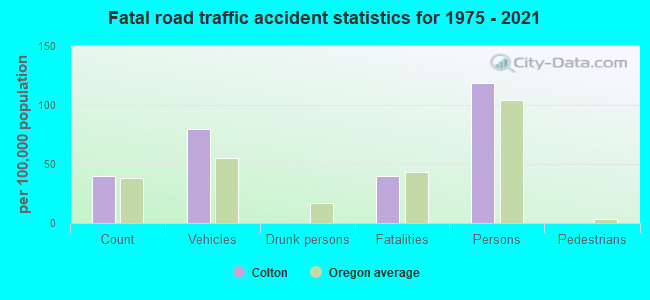
Colton fatal accident list:
Nov 10, 1977 02:30 PM, Vehicles: 2, Persons: 3, Fatalities: 1
FCC Registered Antenna Towers: 13 (See the full list of FCC Registered Antenna Towers)
FCC Registered Broadcast Land Mobile Towers: 9 (See the full list of FCC Registered Broadcast Land Mobile Towers in Colton, OR)
FCC Registered Microwave Towers: 12 (See the full list of FCC Registered Microwave Towers in this town)
FCC Registered Paging Towers: 1 (See the full list of FCC Registered Paging Towers)
FCC Registered Amateur Radio Licenses: 52 (See the full list of FCC Registered Amateur Radio Licenses in Colton)
FAA Registered Aircraft: 14 (See the full list of FAA Registered Aircraft in Colton)
2003 - 2018 National Fire Incident Reporting System (NFIRS) incidents
- Fire incident types reported to NFIRS in Colton, OR
- 14255.3%Structure Fires
- 6726.1%Outside Fires
- 3112.1%Mobile Property/Vehicle Fires
- 176.6%Other
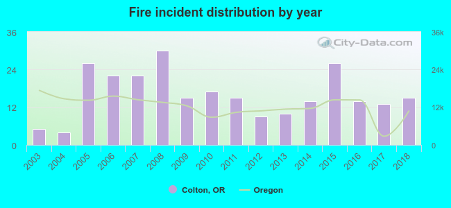 According to the data from the years 2003 - 2018 the average number of fire incidents per year is 16. The highest number of fires - 30 took place in 2008, and the least - 4 in 2004. The data has an increasing trend.
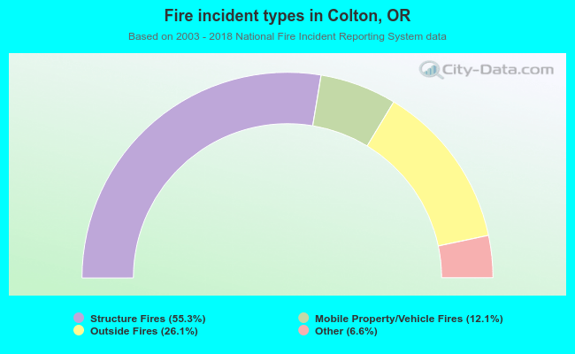 When looking into fire subcategories, the most reports belonged to: Structure Fires (55.3%), and Outside Fires (26.1%).
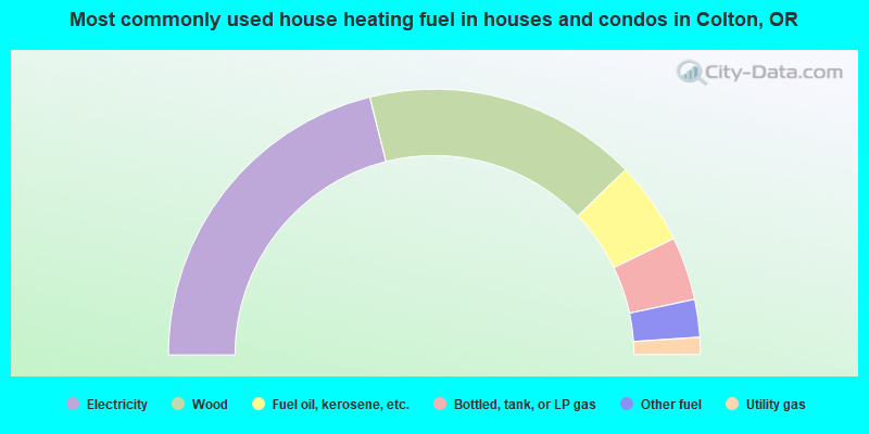
- 42.2%Electricity
- 33.3%Wood
- 10.1%Fuel oil, kerosene, etc.
- 7.7%Bottled, tank, or LP gas
- 4.6%Other fuel
- 2.1%Utility gas
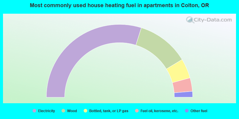
- 59.6%Electricity
- 23.0%Wood
- 8.7%Bottled, tank, or LP gas
- 6.0%Fuel oil, kerosene, etc.
- 2.6%Other fuel
Colton compared to Oregon state average:
- Unemployed percentage below state average.
- Black race population percentage significantly below state average.
- Hispanic race population percentage significantly below state average.
- Foreign-born population percentage significantly below state average.
- Renting percentage significantly below state average.
- Length of stay since moving in significantly above state average.
- Number of rooms per house significantly below state average.
- House age significantly below state average.
- Percentage of population with a bachelor's degree or higher below state average.
Colton on our top lists:
- #2 on the list of "Top 101 cities with largest percentage of females in industries: lumber and other construction materials merchant wholesalers (population 5,000+)"
- #6 on the list of "Top 101 cities with largest percentage of females in industries: vending machine operators (population 5,000+)"
- #10 on the list of "Top 101 cities with largest percentage of females in industries: hardware, plumbing and heating equipment, and supplies merchant wholesalers (population 5,000+)"
- #17 on the list of "Top 101 cities with largest percentage of males in industries: vending machine operators (population 5,000+)"
- #19 on the list of "Top 101 cities with largest percentage of females in occupations: bus drivers (population 5,000+)"
- #19 on the list of "Top 101 cities with largest percentage of females in occupations: fishing and hunting, and forest and logging workers (population 5,000+)"
- #20 on the list of "Top 101 cities with largest percentage of males in industries: broadcasting and telecommunications (population 5,000+)"
- #20 on the list of "Top 101 cities with the most cars per house, population 5,000+"
- #24 on the list of "Top 101 cities with largest percentage of males in occupations: financial clerks except bookkeeping, accounting, and auditing clerks (population 5,000+)"
- #30 on the list of "Top 101 cities with largest percentage of females in occupations: farmers and farm managers (population 5,000+)"
- #34 on the list of "Top 101 cities with largest percentage of males in industries: lumber and other construction materials merchant wholesalers (population 5,000+)"
- #37 on the list of "Top 101 cities with largest percentage of females in industries: petroleum and coal products (population 5,000+)"
- #40 on the list of "Top 101 cities with largest percentage of females in industries: music stores (population 5,000+)"
- #44 on the list of "Top 101 cities with largest percentage of males in occupations: fishing and hunting, and forest and logging workers (population 5,000+)"
- #47 on the list of "Top 101 cities with largest percentage of females in industries: metal and metal products (population 5,000+)"
- #50 on the list of "Top 101 cities with largest percentage of males in industries: wood products (population 5,000+)"
- #51 on the list of "Top 101 cities with largest percentage of females in occupations: sales representatives, services, wholesale and manufacturing (population 5,000+)"
- #63 on the list of "Top 101 cities with largest percentage of females in industries: food and beverage stores (population 5,000+)"
- #66 on the list of "Top 101 cities with largest percentage of females in industries: electrical equipment, appliances, and components (population 5,000+)"
- #68 on the list of "Top 101 cities with largest percentage of females in industries: other direct selling establishments (population 5,000+)"
- #27 on the list of "Top 101 counties with the highest percentage of residents that exercised in the past month"
- #31 on the list of "Top 101 counties with the highest surface withdrawal of fresh water for public supply"
- #44 on the list of "Top 101 counties with the highest total withdrawal of fresh water for public supply"
- #48 on the list of "Top 101 counties with the highest percentage of residents that keep firearms around their homes"
- #78 on the list of "Top 101 counties with the lowest number of births per 1000 residents 2007-2013"

|
|
Total of 7 patent applications in 2008-2024.