Commonwealth, Wisconsin
Submit your own pictures of this town and show them to the world
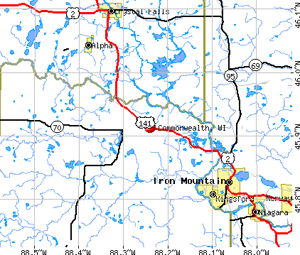
- OSM Map
- General Map
- Google Map
- MSN Map
Population change since 2000: -4.8%
 |
| Males: 207 | |
| Females: 192 |
| Median resident age: | 47.6 years |
| Wisconsin median age: | 42.6 years |
Zip codes: 54121.
| Commonwealth: | $62,222 |
| WI: | $70,996 |
Estimated per capita income in 2022: $38,423 (it was $19,137 in 2000)
Commonwealth town income, earnings, and wages data
Estimated median house or condo value in 2022: $177,519 (it was $83,400 in 2000)
| Commonwealth: | $177,519 |
| WI: | $252,800 |
Mean prices in 2022: all housing units: $210,409; detached houses: $222,884; townhouses or other attached units: $134,430; mobile homes: $60,182
Detailed information about poverty and poor residents in Commonwealth, WI


- 38897.2%White alone
- 51.3%Hispanic
- 30.8%Two or more races
- 20.5%American Indian alone
- 10.3%Asian alone

Races in Commonwealth detailed stats: ancestries, foreign born residents, place of birth
 Recent articles from our blog. Our writers, many of them Ph.D. graduates or candidates, create easy-to-read articles on a wide variety of topics.

 | Why do people want to live "above the beltline"? (20 replies) |
| Paul Ryan planning to eliminate Medicaid, Medicare, and Social Security (70 replies) |
| Fond du Lac Racism Article (9 replies) |
Latest news from Commonwealth, WI collected exclusively by city-data.com from local newspapers, TV, and radio stations
Ancestries: German (36.8%), Polish (14.1%), Italian (13.8%), Swedish (12.2%), French (11.9%), English (9.8%).
Current Local Time: CST time zone
Elevation: 1360 feet
Land area: 42.3 square miles.
Population density: 9.4 people per square mile (very low).
| Commonwealth town: | 1.6% ($1,297) |
| Wisconsin: | 2.0% ($2,245) |
Nearest city with pop. 50,000+: Green Bay, WI  (94.9 miles , pop. 102,313).
Nearest city with pop. 200,000+: Milwaukee, WI (195.8 miles , pop. 596,974).
Nearest city with pop. 1,000,000+: Chicago, IL (280.5 miles , pop. 2,896,016).
Nearest cities:
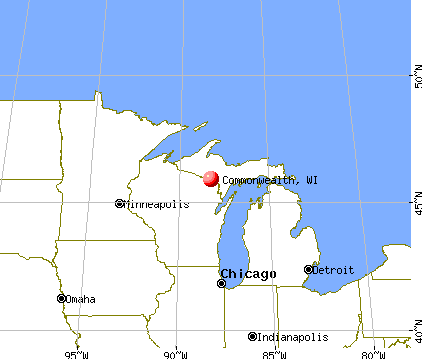
), ), Latitude: 45.87 N, Longitude: 88.27 W
Area code commonly used in this area: 715

| Here: | 3.4% |
| Wisconsin: | 2.7% |
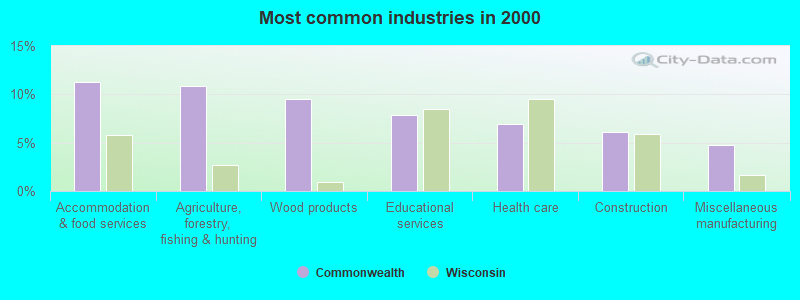
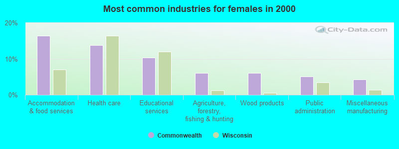
- Accommodation & food services (11.3%)
- Agriculture, forestry, fishing & hunting (10.9%)
- Wood products (9.6%)
- Educational services (7.8%)
- Health care (7.0%)
- Construction (6.1%)
- Miscellaneous manufacturing (4.8%)
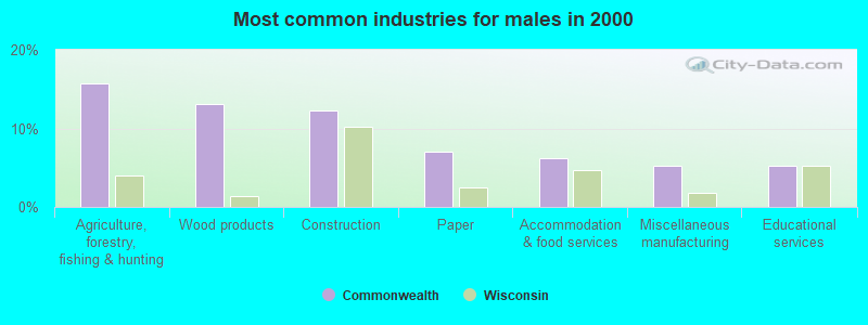
- Agriculture, forestry, fishing & hunting (15.8%)
- Wood products (13.2%)
- Construction (12.3%)
- Paper (7.0%)
- Accommodation & food services (6.1%)
- Miscellaneous manufacturing (5.3%)
- Educational services (5.3%)
- Accommodation & food services (16.4%)
- Health care (13.8%)
- Educational services (10.3%)
- Agriculture, forestry, fishing & hunting (6.0%)
- Wood products (6.0%)
- Public administration (5.2%)
- Miscellaneous manufacturing (4.3%)
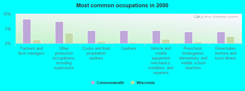
- Farmers and farm managers (8.3%)
- Other production occupations, including supervisors (7.4%)
- Cooks and food preparation workers (4.3%)
- Cashiers (4.3%)
- Vehicle and mobile equipment mechanics, installers, and repairers (4.3%)
- Preschool, kindergarten, elementary, and middle school teachers (3.9%)
- Driver/sales workers and truck drivers (3.9%)
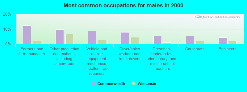
- Farmers and farm managers (12.3%)
- Other production occupations, including supervisors (9.6%)
- Vehicle and mobile equipment mechanics, installers, and repairers (8.8%)
- Driver/sales workers and truck drivers (7.9%)
- Preschool, kindergarten, elementary, and middle school teachers (5.3%)
- Carpenters (5.3%)
- Engineers (4.4%)
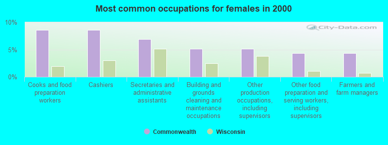
- Cooks and food preparation workers (8.6%)
- Cashiers (8.6%)
- Secretaries and administrative assistants (6.9%)
- Building and grounds cleaning and maintenance occupations (5.2%)
- Other production occupations, including supervisors (5.2%)
- Other food preparation and serving workers, including supervisors (4.3%)
- Farmers and farm managers (4.3%)
Average climate in Commonwealth, Wisconsin
Based on data reported by over 4,000 weather stations


Tornado activity:
Commonwealth-area historical tornado activity is significantly below Wisconsin state average. It is 64% smaller than the overall U.S. average.
On 7/4/1986, a category F3 (max. wind speeds 158-206 mph) tornado 16.5 miles away from the Commonwealth town center injured 12 people and caused between $50,000 and $500,000 in damages.
On 7/11/1987, a category F3 tornado 20.7 miles away from the town center caused between $5000 and $50,000 in damages.
Earthquake activity:
Commonwealth-area historical earthquake activity is significantly above Wisconsin state average. It is 83% smaller than the overall U.S. average.On 5/2/2015 at 16:23:07, a magnitude 4.2 (4.2 MW, Depth: 2.8 mi, Class: Light, Intensity: IV - V) earthquake occurred 288.6 miles away from the city center
On 6/28/2004 at 06:10:52, a magnitude 4.2 (4.2 MW, Depth: 6.2 mi) earthquake occurred 306.9 miles away from Commonwealth center
On 7/9/1975 at 14:54:15, a magnitude 4.6 (4.6 MB) earthquake occurred 374.9 miles away from the city center
On 2/10/2010 at 09:59:35, a magnitude 3.8 (3.8 MW, Depth: 6.2 mi, Class: Light, Intensity: II - III) earthquake occurred 270.3 miles away from Commonwealth center
On 1/31/1986 at 16:46:43, a magnitude 5.0 (5.0 MB, Class: Moderate, Intensity: VI - VII) earthquake occurred 461.9 miles away from Commonwealth center
On 9/25/1998 at 19:52:52, a magnitude 5.2 (4.8 MB, 4.3 MS, 5.2 LG, 4.5 MW, Depth: 3.1 mi) earthquake occurred 496.7 miles away from the city center
Magnitude types: regional Lg-wave magnitude (LG), body-wave magnitude (MB), surface-wave magnitude (MS), moment magnitude (MW)
Natural disasters:
The number of natural disasters in Florence County (5) is a lot smaller than the US average (15).Major Disasters (Presidential) Declared: 3
Emergencies Declared: 2
Causes of natural disasters: Floods: 2, Storms: 2, Drought: 1, Hurricane: 1, Wind: 1, Other: 1 (Note: some incidents may be assigned to more than one category).

Hospitals and medical centers near Commonwealth:
- GOLDEN LIVINGCENTER-FLORENCE (Nursing Home, about 4 miles away; FLORENCE, WI)
- FREEMAN NURSING AND REHAB COMMUNITY (Nursing Home, about 10 miles away; KINGSFORD, MI)
- MANORCARE NURSING AND REHABILITATION CENTER (Nursing Home, about 11 miles away; KINGSFORD, MI)
- DICKINSON IRON DHD DICKINSON SUBUNIT (Home Health Center, about 11 miles away; KINGSFORD, MI)
- PENINSULA HOME HEALTH CARE (Home Health Center, about 11 miles away; IRON MOUNTAIN, MI)
- MARQUETTE GENERAL HOME HEALTH (Home Health Center, about 11 miles away; KINGSFORD, MI)
- DICKINSON HOME HEALTH (Home Health Center, about 11 miles away; IRON MOUNTAIN, MI)
Colleges/universities with over 2000 students nearest to Commonwealth:
- Northern Michigan University (about 64 miles; Marquette, MI; Full-time enrollment: 8,258)
- Michigan Technological University (about 88 miles; Houghton, MI; FT enrollment: 6,078)
- Northcentral Technical College (about 91 miles; Wausau, WI; FT enrollment: 3,356)
- Northeast Wisconsin Technical College (about 94 miles; Green Bay, WI; FT enrollment: 6,069)
- University of Wisconsin-Green Bay (about 95 miles; Green Bay, WI; FT enrollment: 5,415)
- Saint Norbert College (about 100 miles; De Pere, WI; FT enrollment: 2,324)
- Fox Valley Technical College (about 111 miles; Appleton, WI; FT enrollment: 5,682)
Points of interest:
Notable location: Pine River Power Plant (A). Display/hide its location on the map
Cemetery: Saint Marys Cemetery (1). Display/hide its location on the map
Lakes and reservoirs: Sand Lake (A), Emily Lake (B), Hauserman Lake (C), Pine River Flowage 543 (D), Pine River Flowage (E), Halls Lake 4.95 (F), 0.82 Reservoir (G). Display/hide their locations on the map
Creeks: Halls Creek (A), Johnson Creek (B), Pine Creek (C), Deadman Creek (D). Display/hide their locations on the map
Park in Commonwealth: American Legion Park (1). Display/hide its location on the map
| This town: | 2.3 people |
| Wisconsin: | 2.4 people |
| This town: | 67.6% |
| Whole state: | 64.4% |
| This town: | 6.4% |
| Whole state: | 7.3% |
Likely homosexual households (counted as self-reported same-sex unmarried-partner households)
- Lesbian couples: 0.0% of all households
- Gay men: 1.7% of all households
| This town: | 6.4% |
| Whole state: | 8.7% |
| This town: | 3.3% |
| Whole state: | 3.7% |
For population 15 years and over in Commonwealth:
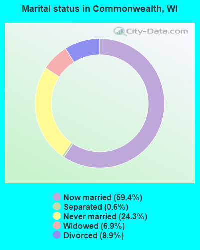
- Never married: 24.3%
- Now married: 59.4%
- Separated: 0.6%
- Widowed: 6.9%
- Divorced: 8.9%
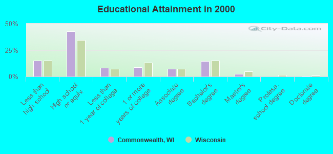
For population 25 years and over in Commonwealth:
- High school or higher: 85.0%
- Bachelor's degree or higher: 17.5%
- Graduate or professional degree: 2.9%
- Unemployed: 4.6%
- Mean travel time to work (commute): 17.1 minutes
| Here: | 10.3 |
| Wisconsin average: | 11.0 |
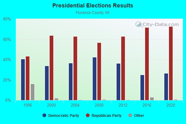
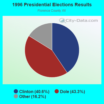
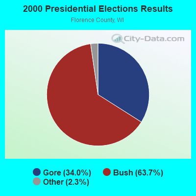
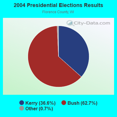
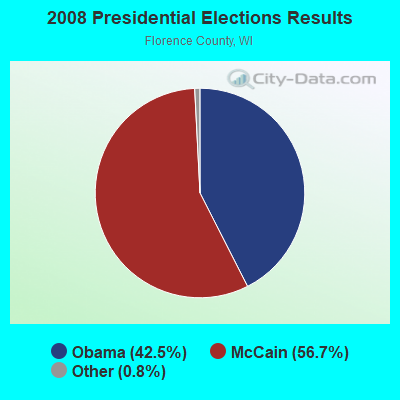
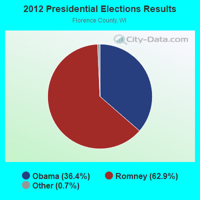
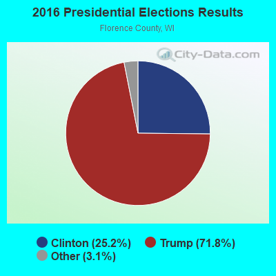
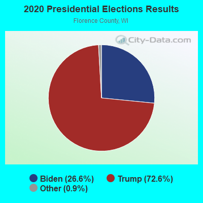
Graphs represent county-level data. Detailed 2008 Election Results
Religion statistics for Commonwealth, WI (based on Florence County data)
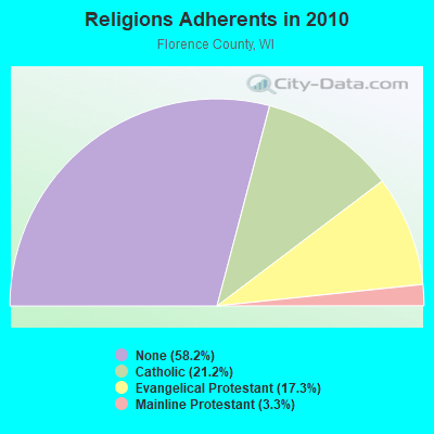
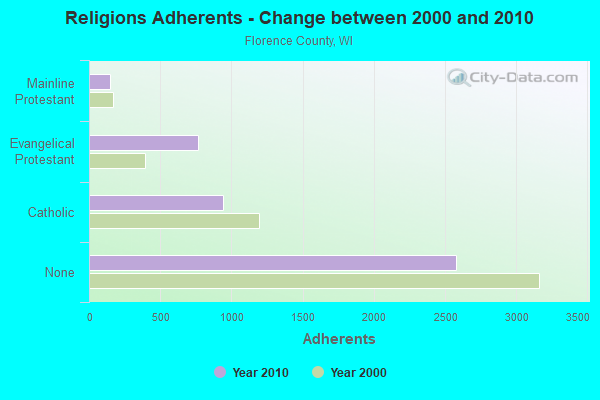
| Religion | Adherents | Congregations |
|---|---|---|
| Catholic | 939 | 3 |
| Evangelical Protestant | 764 | 4 |
| Mainline Protestant | 144 | 2 |
| None | 2,576 | - |
Food Environment Statistics:
| Florence County: | 4.22 / 10,000 pop. |
| Wisconsin: | 1.86 / 10,000 pop. |
| This county: | 2.11 / 10,000 pop. |
| Wisconsin: | 0.38 / 10,000 pop. |
| This county: | 8.43 / 10,000 pop. |
| Wisconsin: | 4.12 / 10,000 pop. |
| This county: | 14.76 / 10,000 pop. |
| Wisconsin: | 8.64 / 10,000 pop. |
| Here: | 8.3% |
| Wisconsin: | 7.6% |
| Florence County: | 27.9% |
| State: | 27.5% |
| Here: | 8.3% |
| Wisconsin: | 13.0% |
Strongest AM radio stations in Commonwealth:
- WMIQ (1450 AM; 1 kW; IRON MOUNTAIN, MI; Owner: NORTHERN STAR BROADCASTING, L.L.C.)
- WDBC (680 AM; 10 kW; ESCANABA, MI; Owner: KMB BROADCASTING, INC.)
- WSPT (1010 AM; 50 kW; STEVENS POINT, WI)
- WSAU (550 AM; 20 kW; WAUSAU, WI; Owner: WRIG, INC.)
- WNAM (1280 AM; 50 kW; NEENAH-MENASHA, WI; Owner: CUMULUS LICENSING CORP.)
- WTCM (580 AM; 35 kW; TRAVERSE CITY, MI; Owner: WTCM RADIO, INC.)
- WEBC (560 AM; 50 kW; DULUTH, MN)
- WIKB (1230 AM; 1 kW; IRON RIVER, MI; Owner: NORTHLAND ADVERTISING, INC.)
- WLDR (1210 AM; daytime; 50 kW; KINGSLEY, MI; Owner: FORT BEND BROADCASTING COMPANY)
- WZAM (970 AM; 5 kW; ISHPEMING, MI)
- WTMJ (620 AM; 50 kW; MILWAUKEE, WI; Owner: JOURNAL BROADCAST CORPORATION)
- WHBY (1150 AM; 25 kW; KIMBERLY, WI; Owner: WOODWARD COMMUNICATIONS, INC.)
- WDMJ (1320 AM; 5 kW; MARQUETTE, MI; Owner: NORTHERN STAR BROADCASTING, L.L.C.)
Strongest FM radio stations in Commonwealth:
- WOBE (100.7 FM; CRYSTAL FALLS, MI; Owner: RESULTS BROADCASTING OF IRON MOUNTAIN, INC.)
- WEUL (98.1 FM; KINGSFORD, MI; Owner: GOSPEL OPPORTUNITIES, INC.)
- WJNR-FM (101.5 FM; IRON MOUNTAIN, MI; Owner: RESULTS BROADCASTING OF IRON MOUNTAIN, INC.)
- WHTO (106.7 FM; IRON MOUNTAIN, MI; Owner: TODD STUART NOORDYK)
- WVCM (91.5 FM; IRON MOUNTAIN, MI; Owner: VCY AMERICA INC.)
- W244AW (96.7 FM; IRON MOUNTAIN, MI; Owner: FAMILY ED BC CORP OF DOOR CNTY WI)
- WIMK (93.1 FM; IRON MOUNTAIN, MI; Owner: NORTHERN STAR BROADCASTING, L.L.C.)
- WZNL (94.3 FM; NORWAY, MI; Owner: NORTHERN STAR BROADCASTING, L.L.C.)
- WIKB-FM (99.1 FM; IRON RIVER, MI; Owner: NORTHLAND ADVERTISING, INC.)
- WMVM (91.3 FM; GOODMAN, WI; Owner: WRVM, INC.)
- WYKX (104.7 FM; ESCANABA, MI; Owner: KMB BROADCASTING, INC.)
- WNMU-FM (90.1 FM; MARQUETTE, MI; Owner: NORTHERN MICHIGAN UNIVERSITY)
TV broadcast stations around Commonwealth:
- KTTM (Channel 12; HURON, SD; Owner: INDEPENDENT COMMUNICATIONS, INC.)
- W54AR (Channel 54; FENCE, WI; Owner: STATE OF WISCONSIN - EDUCATIONAL COMMUNICATIONS BOARD)
- WYOW (Channel 34; EAGLE RIVER, WI; Owner: WAOW-WYOW TELEVISION, INC.)
- WJFW-TV (Channel 12; RHINELANDER, WI; Owner: NORTHLAND TELEVISION, INC.)
- WLUC-TV (Channel 6; MARQUETTE, MI; Owner: WLUC LICENSE SUBSIDIARY, INC.)
- WDHS (Channel 8; IRON MOUNTAIN, MI; Owner: W. RUSSELL WITHERS, JR.)
- National Bridge Inventory (NBI) Statistics
- 2Number of bridges
- 23ft / 7.4mTotal length
- 2,633Total average daily traffic
- 165Total average daily truck traffic
- 3,126Total future (year 2039) average daily traffic
FCC Registered Cell Phone Towers:
1- Commonwealth Cell Site: 1.6 Km South Of (Lat: 45.896944 Lon: -88.245278), Type: Tower, Structure height: 71.9 m, Overall height: 82.6 m, Call Sign: WPTH846, Licensee ID: L00169810
Assigned Frequencies: 869.040 MHz, 890.010 MHz, 824.040 MHz, 845.010 MHzGrant Date: 10/05/2001, Expiration Date: 04/02/2002, Cancellation Date: 06/23/2002, Certifier: Timothy J DuffyRegistrant: Acc Wisconsin License LLC
FCC Registered Antenna Towers:
6- Stormy M Seibt, 1.6 Km South (Lat: 45.896944 Lon: -88.245278), Type: 82.6, Overall height: 71.9 m, Registrant: American Tower Limited Partnership, Schau-mburg, Phone: (847) 240-1508
- Lottie L Thompson, 1.6 Km South (Lat: 45.896944 Lon: -88.245278), Type: 82.6, Overall height: 71.9 m, Registrant: American Tower Management, Inc., Schau-mburg, Phone: (847) 240-1508
- Lottie L Thompson, 1 Mi South Off Hwy N. (Commonwealth# 87989) (Lat: 45.897083 Lon: -88.245583), Type: 81.7, Overall height: 71.6 m, Registrant: American Tower Management, Inc., Schau-mburg, Phone: (847) 240-1508
- Lottie L Thompson, 1 Mi South Off Hwy N. (Commonwealth# 87989) (Lat: 45.897083 Lon: -88.245583), Type: 81.7, Overall height: 71.6 m, Registrant: American Tower Management, Inc., Schau-mburg, Phone: (847) 240-1508
- Lottie L Thompson, 1 Mi South Off Hwy N. (Commonwealth# 87989) (Lat: 45.897083 Lon: -88.245583), Type: 81.7, Overall height: 71.6 m, Registrant: American Towers, Inc., Schau-mburg, Phone: (847) 240-1508
- 1.6 Km South (Lat: 45.896944 Lon: -88.245278), Type: 82.6, Overall height: 71.9 m, Registrant: At&t Corp, Pcheeks@att.Com, , Atlan-ta, Phone: (404) 810-4021
FCC Registered Microwave Towers:
1- COMONWEALTH, 1.0 Mi S Of (Lat: 45.896889 Lon: -88.245389), Overall height: 82.6 m, Call Sign: KSJ40,
Assigned Frequencies: 3830.00 MHz, 3830.00 MHz, 3990.00 MHz, 4070.00 MHz, 4070.00 MHz, 4150.00 MHz, 4150.00 MHz, 3990.00 MHz, Grant Date: 02/02/2010, Expiration Date: 02/01/2020, Cancellation Date: 01/24/2011, Registrant: At&t Corp., 2315 Salem Road, First Floor, H9, Conyers, GA 30013, Phone: (770) 602-2065, Fax: (770) 929-4454, Email:
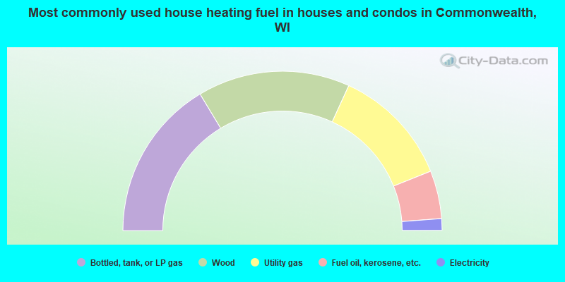
- 32.7%Bottled, tank, or LP gas
- 30.9%Wood
- 24.2%Utility gas
- 9.7%Fuel oil, kerosene, etc.
- 2.4%Electricity
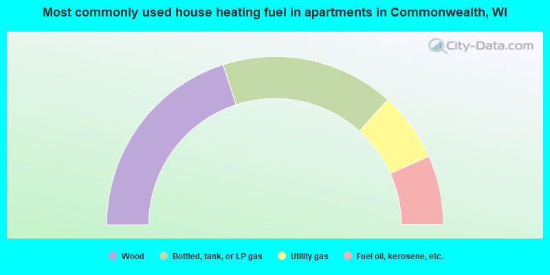
- 40.0%Wood
- 33.3%Bottled, tank, or LP gas
- 13.3%Utility gas
- 13.3%Fuel oil, kerosene, etc.
Commonwealth compared to Wisconsin state average:
- Unemployed percentage below state average.
- Black race population percentage significantly below state average.
- Hispanic race population percentage significantly below state average.
- Median age above state average.
- Foreign-born population percentage significantly below state average.
- Renting percentage significantly below state average.
- Length of stay since moving in significantly above state average.
- Number of rooms per house significantly below state average.
- House age significantly below state average.
- Number of college students below state average.