Homestead, Wisconsin
Submit your own pictures of this town and show them to the world
- OSM Map
- Google Map
- MSN Map
Population change since 2000: -11.1%
 |
| Males: 178 | |
| Females: 158 |
| Median resident age: | 51.3 years |
| Wisconsin median age: | 42.6 years |
Zip codes: 54121.
| Homestead: | $52,285 |
| WI: | $70,996 |
Estimated per capita income in 2022: $43,150 (it was $21,491 in 2000)
Homestead town income, earnings, and wages data
Estimated median house or condo value in 2022: $146,655 (it was $68,900 in 2000)
| Homestead: | $146,655 |
| WI: | $252,800 |
Mean prices in 2022: all housing units: $210,409; detached houses: $222,884; townhouses or other attached units: $134,430; mobile homes: $60,182
Detailed information about poverty and poor residents in Homestead, WI


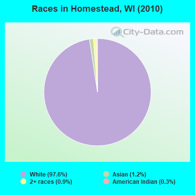
- 32897.6%White alone
- 41.2%Asian alone
- 30.9%Two or more races
- 10.3%American Indian alone
Races in Homestead detailed stats: ancestries, foreign born residents, place of birth
 Recent articles from our blog. Our writers, many of them Ph.D. graduates or candidates, create easy-to-read articles on a wide variety of topics.
Ancestries: German (31.2%), Swedish (23.5%), Norwegian (10.6%), Irish (9.3%), English (9.0%), Polish (7.7%).
Current Local Time: CST time zone
Land area: 53.9 square miles.
Population density: 6.2 people per square mile (very low).
2 residents are foreign born
| This town: | 0.5% |
| Wisconsin: | 3.6% |
| Homestead town: | 1.4% ($991) |
| Wisconsin: | 2.0% ($2,245) |
Nearest city with pop. 50,000+: Green Bay, WI  (87.5 miles , pop. 102,313).
Nearest city with pop. 200,000+: Milwaukee, WI (188.3 miles , pop. 596,974).
Nearest city with pop. 1,000,000+: Chicago, IL (273.0 miles , pop. 2,896,016).
Nearest cities:
), ), Latitude: 45.76 N, Longitude: 88.28 W
Area code commonly used in this area: 715
| Here: | 3.4% |
| Wisconsin: | 2.7% |
- Construction (9.9%)
- Health care (9.9%)
- Paper (7.7%)
- Public administration (7.7%)
- Agriculture, forestry, fishing & hunting (7.1%)
- Educational services (6.6%)
- U. S. Postal service (6.0%)
- Paper (14.1%)
- Construction (11.1%)
- Agriculture, forestry, fishing & hunting (10.1%)
- Wood products (8.1%)
- Metal & metal products (7.1%)
- Truck transportation (7.1%)
- Repair & maintenance (7.1%)
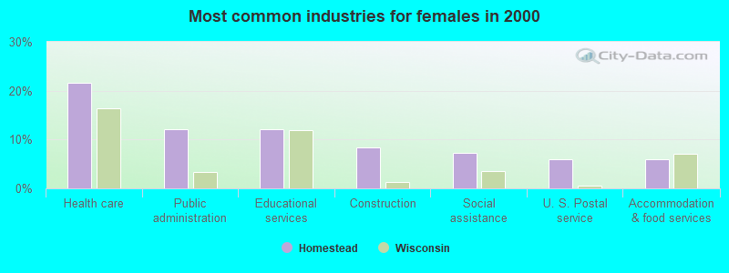
- Health care (21.7%)
- Public administration (12.0%)
- Educational services (12.0%)
- Construction (8.4%)
- Social assistance (7.2%)
- U. S. Postal service (6.0%)
- Accommodation & food services (6.0%)
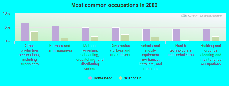
- Other production occupations, including supervisors (6.6%)
- Farmers and farm managers (5.5%)
- Material recording, scheduling, dispatching, and distributing workers (4.9%)
- Driver/sales workers and truck drivers (4.9%)
- Vehicle and mobile equipment mechanics, installers, and repairers (4.4%)
- Health technologists and technicians (4.4%)
- Building and grounds cleaning and maintenance occupations (4.4%)
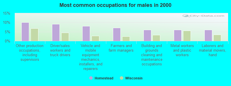
- Other production occupations, including supervisors (10.1%)
- Driver/sales workers and truck drivers (9.1%)
- Vehicle and mobile equipment mechanics, installers, and repairers (8.1%)
- Farmers and farm managers (7.1%)
- Building and grounds cleaning and maintenance occupations (6.1%)
- Metal workers and plastic workers (6.1%)
- Laborers and material movers, hand (6.1%)
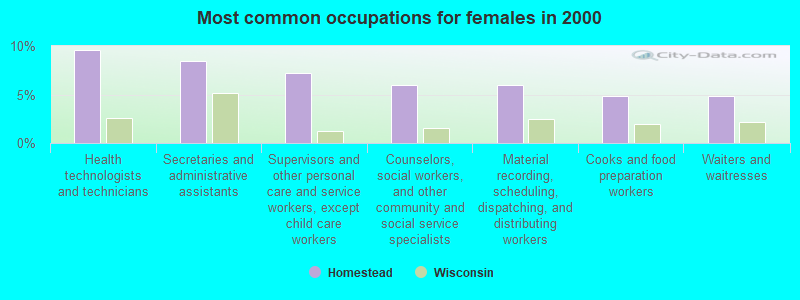
- Health technologists and technicians (9.6%)
- Secretaries and administrative assistants (8.4%)
- Supervisors and other personal care and service workers, except child care workers (7.2%)
- Counselors, social workers, and other community and social service specialists (6.0%)
- Material recording, scheduling, dispatching, and distributing workers (6.0%)
- Cooks and food preparation workers (4.8%)
- Waiters and waitresses (4.8%)
Average climate in Homestead, Wisconsin
Based on data reported by over 4,000 weather stations


Tornado activity:
Homestead-area historical tornado activity is significantly below Wisconsin state average. It is 60% smaller than the overall U.S. average.
On 7/4/1986, a category F3 (max. wind speeds 158-206 mph) tornado 13.6 miles away from the Homestead town center injured 12 people and caused between $50,000 and $500,000 in damages.
On 7/11/1987, a category F3 tornado 19.7 miles away from the town center caused between $5000 and $50,000 in damages.
Earthquake activity:
Homestead-area historical earthquake activity is significantly above Wisconsin state average. It is 83% smaller than the overall U.S. average.On 5/2/2015 at 16:23:07, a magnitude 4.2 (4.2 MW, Depth: 2.8 mi, Class: Light, Intensity: IV - V) earthquake occurred 282.2 miles away from the city center
On 6/28/2004 at 06:10:52, a magnitude 4.2 (4.2 MW, Depth: 6.2 mi) earthquake occurred 299.3 miles away from the city center
On 7/9/1975 at 14:54:15, a magnitude 4.6 (4.6 MB) earthquake occurred 374.8 miles away from the city center
On 2/10/2010 at 09:59:35, a magnitude 3.8 (3.8 MW, Depth: 6.2 mi, Class: Light, Intensity: II - III) earthquake occurred 262.7 miles away from the city center
On 1/31/1986 at 16:46:43, a magnitude 5.0 (5.0 MB, Class: Moderate, Intensity: VI - VII) earthquake occurred 457.6 miles away from Homestead center
On 9/25/1998 at 19:52:52, a magnitude 5.2 (4.8 MB, 4.3 MS, 5.2 LG, 4.5 MW, Depth: 3.1 mi) earthquake occurred 492.6 miles away from Homestead center
Magnitude types: regional Lg-wave magnitude (LG), body-wave magnitude (MB), surface-wave magnitude (MS), moment magnitude (MW)
Natural disasters:
The number of natural disasters in Florence County (5) is a lot smaller than the US average (15).Major Disasters (Presidential) Declared: 3
Emergencies Declared: 2
Causes of natural disasters: Floods: 2, Storms: 2, Drought: 1, Hurricane: 1, Wind: 1, Other: 1 (Note: some incidents may be assigned to more than one category).
Hospitals and medical centers near Homestead:
- FREEMAN NURSING AND REHAB COMMUNITY (Nursing Home, about 9 miles away; KINGSFORD, MI)
- MANORCARE NURSING AND REHABILITATION CENTER (Nursing Home, about 10 miles away; KINGSFORD, MI)
- DICKINSON IRON DHD DICKINSON SUBUNIT (Home Health Center, about 10 miles away; KINGSFORD, MI)
- MARQUETTE GENERAL HOME HEALTH (Home Health Center, about 11 miles away; KINGSFORD, MI)
- PENINSULA HOME HEALTH CARE (Home Health Center, about 11 miles away; IRON MOUNTAIN, MI)
- IRON MOUNTAIN MI VA MEDICAL CENTER (Hospital, Acute Care - Veterans Administration, about 11 miles away; IRON MOUNTAIN, MI)
- DICKINSON HOME HEALTH (Home Health Center, about 11 miles away; IRON MOUNTAIN, MI)
Colleges/universities with over 2000 students nearest to Homestead:
- Northern Michigan University (about 70 miles; Marquette, MI; Full-time enrollment: 8,258)
- Northcentral Technical College (about 86 miles; Wausau, WI; FT enrollment: 3,356)
- Northeast Wisconsin Technical College (about 87 miles; Green Bay, WI; FT enrollment: 6,069)
- University of Wisconsin-Green Bay (about 88 miles; Green Bay, WI; FT enrollment: 5,415)
- Saint Norbert College (about 92 miles; De Pere, WI; FT enrollment: 2,324)
- Michigan Technological University (about 95 miles; Houghton, MI; FT enrollment: 6,078)
- Fox Valley Technical College (about 103 miles; Appleton, WI; FT enrollment: 5,682)
Points of interest:
Notable locations in Homestead: Homestead (A), Homestead Volunteer Fire Department (B). Display/hide their locations on the map
Lakes: Sand Lake (A), Scout Lake (B), Bass Lake (C), Buckskin Lake (D), Bush Lake (E), West Bass Lake (F), Hord Lake (G), Marm Lake (H). Display/hide their locations on the map
Streams, rivers, and creeks: Sand Lake Branch (A), Lund Creek (B), South Branch Little Popple River (C). Display/hide their locations on the map
Park in Homestead: Homestead Park (1). Display/hide its location on the map
| This town: | 2.2 people |
| Wisconsin: | 2.4 people |
| This town: | 71.3% |
| Whole state: | 64.4% |
| This town: | 1.3% |
| Whole state: | 7.3% |
No gay or lesbian households reported
| This town: | 4.2% |
| Whole state: | 8.7% |
| This town: | 2.6% |
| Whole state: | 3.7% |
For population 15 years and over in Homestead:
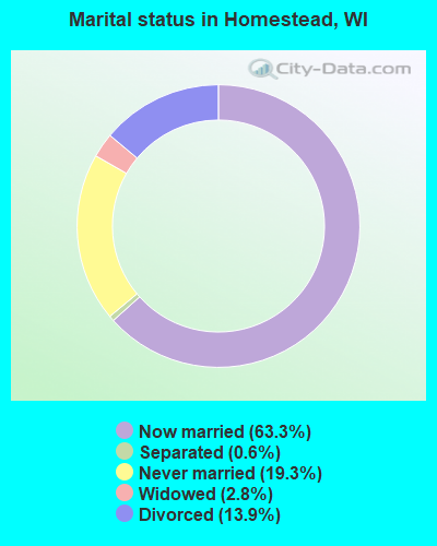
- Never married: 19.3%
- Now married: 63.3%
- Separated: 0.6%
- Widowed: 2.8%
- Divorced: 13.9%
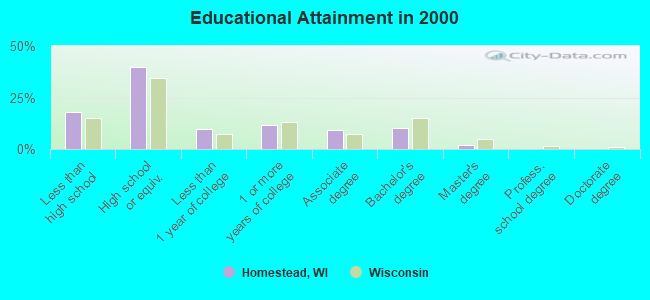
For population 25 years and over in Homestead:
- High school or higher: 82.0%
- Bachelor's degree or higher: 11.9%
- Graduate or professional degree: 1.8%
- Unemployed: 7.1%
- Mean travel time to work (commute): 23.3 minutes
| Here: | 8.6 |
| Wisconsin average: | 11.0 |
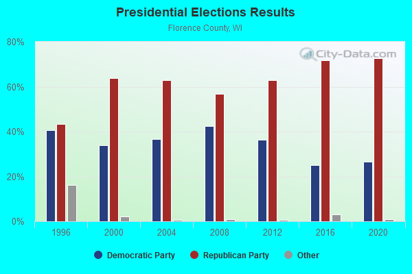
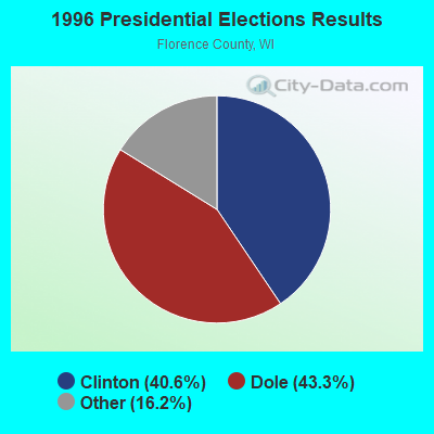
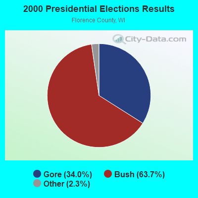
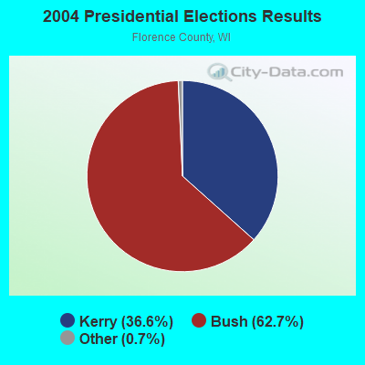
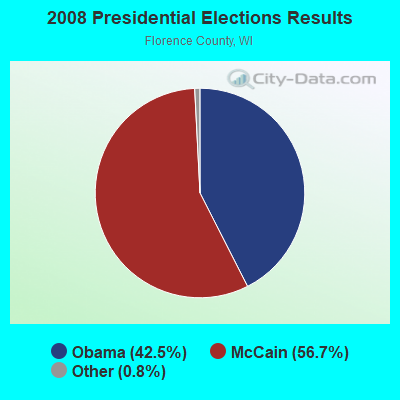
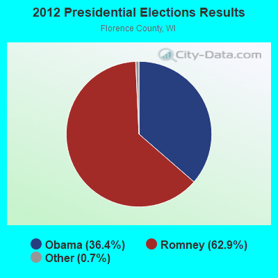
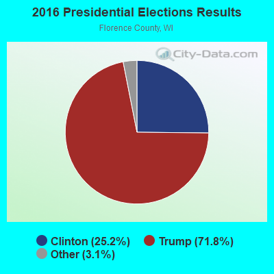
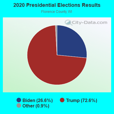
Graphs represent county-level data. Detailed 2008 Election Results
Religion statistics for Homestead, WI (based on Florence County data)
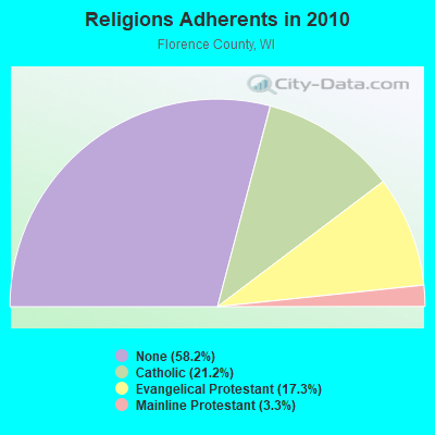
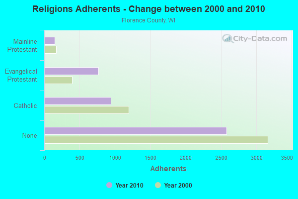
| Religion | Adherents | Congregations |
|---|---|---|
| Catholic | 939 | 3 |
| Evangelical Protestant | 764 | 4 |
| Mainline Protestant | 144 | 2 |
| None | 2,576 | - |
Food Environment Statistics:
| Here: | 4.22 / 10,000 pop. |
| Wisconsin: | 1.86 / 10,000 pop. |
| Florence County: | 2.11 / 10,000 pop. |
| Wisconsin: | 0.38 / 10,000 pop. |
| Here: | 8.43 / 10,000 pop. |
| State: | 4.12 / 10,000 pop. |
| Florence County: | 14.76 / 10,000 pop. |
| Wisconsin: | 8.64 / 10,000 pop. |
| This county: | 8.3% |
| Wisconsin: | 7.6% |
| This county: | 27.9% |
| Wisconsin: | 27.5% |
| This county: | 8.3% |
| State: | 13.0% |
Strongest AM radio stations in Homestead:
- WMIQ (1450 AM; 1 kW; IRON MOUNTAIN, MI; Owner: NORTHERN STAR BROADCASTING, L.L.C.)
- WSPT (1010 AM; 50 kW; STEVENS POINT, WI)
- WDBC (680 AM; 10 kW; ESCANABA, MI; Owner: KMB BROADCASTING, INC.)
- WSAU (550 AM; 20 kW; WAUSAU, WI; Owner: WRIG, INC.)
- WNAM (1280 AM; 50 kW; NEENAH-MENASHA, WI; Owner: CUMULUS LICENSING CORP.)
- WTCM (580 AM; 35 kW; TRAVERSE CITY, MI; Owner: WTCM RADIO, INC.)
- WEBC (560 AM; 50 kW; DULUTH, MN)
- WLDR (1210 AM; daytime; 50 kW; KINGSLEY, MI; Owner: FORT BEND BROADCASTING COMPANY)
- WTMJ (620 AM; 50 kW; MILWAUKEE, WI; Owner: JOURNAL BROADCAST CORPORATION)
- WHBY (1150 AM; 25 kW; KIMBERLY, WI; Owner: WOODWARD COMMUNICATIONS, INC.)
- WZAM (970 AM; 5 kW; ISHPEMING, MI)
- WIKB (1230 AM; 1 kW; IRON RIVER, MI; Owner: NORTHLAND ADVERTISING, INC.)
- WISN (1130 AM; 50 kW; MILWAUKEE, WI; Owner: CAPSTAR TX LIMITED PARTNERSHIP)
Strongest FM radio stations in Homestead:
- WOBE (100.7 FM; CRYSTAL FALLS, MI; Owner: RESULTS BROADCASTING OF IRON MOUNTAIN, INC.)
- WJNR-FM (101.5 FM; IRON MOUNTAIN, MI; Owner: RESULTS BROADCASTING OF IRON MOUNTAIN, INC.)
- WHTO (106.7 FM; IRON MOUNTAIN, MI; Owner: TODD STUART NOORDYK)
- WVCM (91.5 FM; IRON MOUNTAIN, MI; Owner: VCY AMERICA INC.)
- W244AW (96.7 FM; IRON MOUNTAIN, MI; Owner: FAMILY ED BC CORP OF DOOR CNTY WI)
- WIMK (93.1 FM; IRON MOUNTAIN, MI; Owner: NORTHERN STAR BROADCASTING, L.L.C.)
- WEUL (98.1 FM; KINGSFORD, MI; Owner: GOSPEL OPPORTUNITIES, INC.)
- WMVM (91.3 FM; GOODMAN, WI; Owner: WRVM, INC.)
- WZNL (94.3 FM; NORWAY, MI; Owner: NORTHERN STAR BROADCASTING, L.L.C.)
- WYKX (104.7 FM; ESCANABA, MI; Owner: KMB BROADCASTING, INC.)
- WIKB-FM (99.1 FM; IRON RIVER, MI; Owner: NORTHLAND ADVERTISING, INC.)
TV broadcast stations around Homestead:
- W54AR (Channel 54; FENCE, WI; Owner: STATE OF WISCONSIN - EDUCATIONAL COMMUNICATIONS BOARD)
- KTTM (Channel 12; HURON, SD; Owner: INDEPENDENT COMMUNICATIONS, INC.)
- WYOW (Channel 34; EAGLE RIVER, WI; Owner: WAOW-WYOW TELEVISION, INC.)
- WJFW-TV (Channel 12; RHINELANDER, WI; Owner: NORTHLAND TELEVISION, INC.)
- WDHS (Channel 8; IRON MOUNTAIN, MI; Owner: W. RUSSELL WITHERS, JR.)
- National Bridge Inventory (NBI) Statistics
- 1Number of bridges
- 13ft / 4.0mTotal length
- 1,648Total average daily traffic
- 1,812Total future (year 2039) average daily traffic
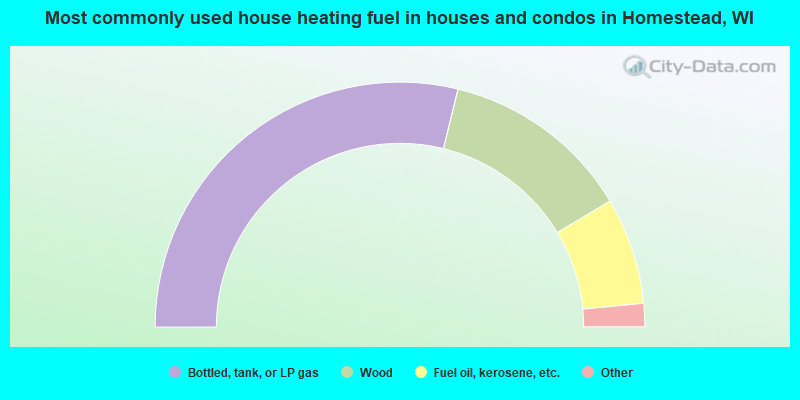
- 57.7%Bottled, tank, or LP gas
- 25.2%Wood
- 14.1%Fuel oil, kerosene, etc.
- 1.8%No fuel used
- 1.2%Utility gas
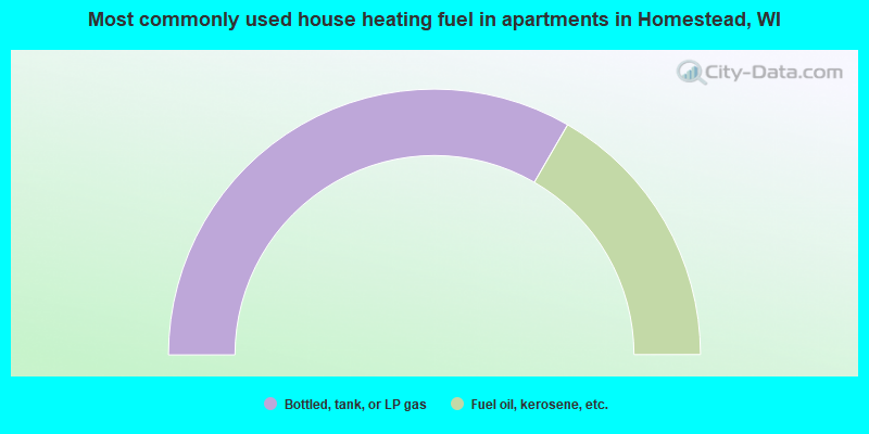
- 66.7%Bottled, tank, or LP gas
- 33.3%Fuel oil, kerosene, etc.
Homestead compared to Wisconsin state average:
- Median house value below state average.
- Unemployed percentage below state average.
- Black race population percentage significantly below state average.
- Hispanic race population percentage significantly below state average.
- Median age significantly above state average.
- Foreign-born population percentage significantly below state average.
- Renting percentage significantly below state average.
- Length of stay since moving in significantly above state average.
- Number of rooms per house significantly below state average.
- House age significantly below state average.
- Number of college students significantly below state average.
- Percentage of population with a bachelor's degree or higher below state average.