Cottonton-Seale, Alabama
Submit your own pictures of this place and show them to the world
- OSM Map
- Google Map
- MSN Map
| Males: 2,372 | |
| Females: 2,392 |
| Median resident age: | 36.0 years |
| Alabama median age: | 35.8 years |
Zip code: 36871
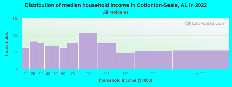
| Cottonton-Seale: | $49,704 |
| AL: | $59,674 |
Estimated per capita income in 2022: $23,038 (it was $12,328 in 2000)
Cottonton-Seale CCD income, earnings, and wages data
Estimated median house or condo value in 2022: $129,577 (it was $53,900 in 2000)
| Cottonton-Seale: | $129,577 |
| AL: | $200,900 |
Mean prices in 2022: all housing units: $197,542; detached houses: $217,366; townhouses or other attached units: $261,531; in 2-unit structures: $142,197; in 3-to-4-unit structures: $107,970; in 5-or-more-unit structures: $190,114; mobile homes: $71,019; occupied boats, rvs, vans, etc.: $259,186
Cottonton-Seale, AL residents, houses, and apartments details
Detailed information about poverty and poor residents in Cottonton-Seale, AL
Compare current foreclosures near your location:
| Photo | Address | Area | Beds / Baths | Price | Details |
|---|---|---|---|---|---|

|
#1
S High St
Columbus, OH 43207
|
1,678 sq. feet
|
2 baths 4 beds |
$31,900
|
show details |

|
#2
Bayberry Cir
Columbus, OH 43207
|
1,564 sq. feet
|
1 baths 3 beds |
$127,500
|
show details |

|
#3
E 21st Ave
Columbus, OH 43211
|
1,061 sq. feet
|
1 baths 3 beds |
$179,900
|
show details |

|
#4
Fairfield Ave
Columbus, OH 43203
|
984 sq. feet
|
1 baths 2 beds |
show details | |

|
#5
Executive Ct
Westerville, OH 43081
|
1,811 sq. feet
|
2 baths 3 beds |
show details | |

|
#6
Hiawatha Park Dr
Columbus, OH 43211
|
1,278 sq. feet
|
1 baths 4 beds |
show details | |

|
#7
Fergus Rd
Grove City, OH 43123
|
3,312 sq. feet
|
2 baths 4 beds |
show details | |

|
#8
Cannonade Ct
Columbus, OH 43230
|
2,023 sq. feet
|
2 baths 3 beds |
show details | |

|
#9
E Welch Ave
Columbus, OH 43207
|
1,864 sq. feet
|
2 baths 4 beds |
show details | |

|
#10
S Hague Ave
Columbus, OH 43204
|
979 sq. feet
|
1 baths 2 beds |
show details |
| Photo | Address | Area | Beds / Baths | Price | Details |
|---|---|---|---|---|---|

|
#11
E Lincoln Ave
Columbus, OH 43214
|
874 sq. feet
|
1 baths 3 beds |
show details | |

|
#12
S Champion Ave
Columbus, OH 43207
|
1,157 sq. feet
|
1 baths 2 beds |
show details | |

|
#13
Chester Rd
Columbus, OH 43221
|
3,300 sq. feet
|
4 baths 5 beds |
show details | |

|
#14
Striebel Ct
Columbus, OH 43227
|
925 sq. feet
|
1 baths 3 beds |
show details | |

|
#15
Lehner Rd
Columbus, OH 43224
|
1,628 sq. feet
|
2 baths 4 beds |
show details | |

|
#16
Upton Rd E
Columbus, OH 43232
|
852 sq. feet
|
1 baths 3 beds |
show details | |

|
#17
Armada Rd
Columbus, OH 43232
|
1,028 sq. feet
|
1 baths 4 beds |
show details | |

|
#18
Wrexham Ave
Columbus, OH 43223
|
1,235 sq. feet
|
1 baths 3 beds |
show details | |

|
#19
E Howard Rd
Columbus, OH 43207
|
1,056 sq. feet
|
1 baths 3 beds |
show details | |

|
#20
Summertree Ln
Westerville, OH 43081
|
2,496 sq. feet
|
2 baths 3 beds |
show details |
| Photo | Address | Area | Beds / Baths | Price | Details |
|---|---|---|---|---|---|

|
#21
London Groveport Rd
Grove City, OH 43123
|
816 sq. feet
|
1 baths 2 beds |
show details | |

|
#22
N Roys Ave
Columbus, OH 43204
|
1,248 sq. feet
|
2 baths 3 beds |
show details | |

|
#23
Chidley St
Galloway, OH 43119
|
1,502 sq. feet
|
1 baths 3 beds |
show details | |

|
#24
Glenmate Ct
Columbus, OH 43223
|
1,050 sq. feet
|
1 baths 3 beds |
show details | |

|
#25
High Free Pike
West Jefferson, OH 43162
|
1,216 sq. feet
|
2 baths 4 beds |
show details | |

|
#26
Gladys Rd
Columbus, OH 43228
|
832 sq. feet
|
1 baths 3 beds |
show details | |

|
#27
Whittman Ct
Plain City, OH 43064
|
3,186 sq. feet
|
3 baths 4 beds |
show details | |

|
#28
Hamilton Ave
Columbus, OH 43211
|
1,061 sq. feet
|
1 baths 3 beds |
show details | |

|
#29
Hildreth Ave
Columbus, OH 43203
|
1,798 sq. feet
|
2 baths 4 beds |
show details | |

|
#30
Ashgrove Dr
Grove City, OH 43123
|
1,772 sq. feet
|
2 baths 4 beds |
show details |
| Photo | Address | Area | Beds / Baths | Price | Details |
|---|---|---|---|---|---|

|
#31
S Richardson Ave
Columbus, OH 43204
|
1,520 sq. feet
|
2 baths 3 beds |
show details | |

|
#32
Kelton Ave
Columbus, OH 43206
|
1,080 sq. feet
|
1 baths 3 beds |
show details | |

|
#33
Meadowbrook Dr
Columbus, OH 43207
|
1,752 sq. feet
|
2 baths 4 beds |
show details | |

|
#34
Falls Peak Ln
Delaware, OH 43015
|
1,352 sq. feet
|
2 baths 2 beds |
show details | |

|
#35
N 18th St
Columbus, OH 43203
|
1,690 sq. feet
|
1 baths 4 beds |
show details | |

|
#36
Grasmere Ave
Columbus, OH 43211
|
720 sq. feet
|
1 baths 2 beds |
show details | |

|
#37
Huxley Dr
Columbus, OH 43227
|
1,284 sq. feet
|
1 baths 3 beds |
show details | |

|
#38
Morgan Ln
Columbus, OH 43230
|
4,619 sq. feet
|
5 baths 6 beds |
show details | |

|
#39
Allwood Ct
Columbus, OH 43231
|
1,683 sq. feet
|
2 baths 3 beds |
show details | |

|
#40
Colorado Ave
Groveport, OH 43125
|
1,502 sq. feet
|
1 baths 3 beds |
show details |
| Photo | Address | Area | Beds / Baths | Price | Details |
|---|---|---|---|---|---|

|
#41
Doral Ave
Columbus, OH 43213
|
2,124 sq. feet
|
2 baths 4 beds |
show details | |

|
#42
Beechview Dr S
Columbus, OH 43085
|
1,998 sq. feet
|
1 baths 3 beds |
show details | |

|
#43
Westrock Dr
Hilliard, OH 43026
|
1,624 sq. feet
|
2 baths 4 beds |
show details | |

|
#44
Jed Ct
Columbus, OH 43227
|
1,086 sq. feet
|
1 baths 3 beds |
show details | |

|
#45
Wendler Blvd
Columbus, OH 43230
|
1,040 sq. feet
|
1 baths 3 beds |
show details | |

|
#46
Morality Dr
Columbus, OH 43231
|
1,903 sq. feet
|
2 baths 4 beds |
show details | |

|
#47
Gertrude Dr
Columbus, OH 43227
|
1,287 sq. feet
|
1 baths 3 beds |
show details | |

|
#48
Mayflower Cir
Grove City, OH 43123
|
2,084 sq. feet
|
2 baths 4 beds |
show details | |

|
#49
Crocker Rd
Columbus, OH 43232
|
895 sq. feet
|
1 baths 3 beds |
show details | |

|
Check over 1 million property listings on Foreclosure.com!
|
browse all offers | |||

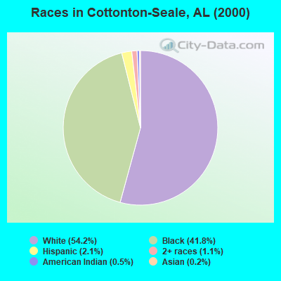
- 2,55554.2%White alone
- 1,97241.8%Black alone
- 1012.1%Hispanic
- 501.1%Two or more races
- 250.5%American Indian alone
- 90.2%Asian alone
- 10.02%Native Hawaiian and Other
Pacific Islander alone - 10.02%Other race alone
 Recent articles from our blog. Our writers, many of them Ph.D. graduates or candidates, create easy-to-read articles on a wide variety of topics.

Current Local Time: CST time zone
Land area: 258.4 square miles.
Population density: 18 people per square mile (very low).
| Cottonton-Seale CCD: | 0.4% ($199) |
| Alabama: | 0.4% ($289) |
Nearest city with pop. 50,000+: Columbus, GA  (21.3 miles , pop. 185,781).
Nearest city with pop. 200,000+: Montgomery, AL (68.1 miles , pop. 201,568).
Nearest city with pop. 1,000,000+: Houston, TX (631.2 miles , pop. 1,953,631).
Nearest cities:
), ), ), ), ), ), ), )Latitude: 32.22 N, Longitude: 85.13 W
Area code commonly used in this area: 334
| Here: | 3.0% |
| Alabama: | 2.6% |
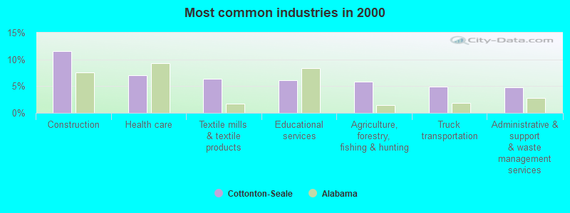
- Construction (11.6%)
- Health care (7.1%)
- Textile mills & textile products (6.4%)
- Educational services (6.0%)
- Agriculture, forestry, fishing & hunting (5.8%)
- Truck transportation (4.9%)
- Administrative & support & waste management services (4.8%)
- Construction (19.1%)
- Truck transportation (8.3%)
- Agriculture, forestry, fishing & hunting (7.8%)
- Paper (6.7%)
- Textile mills & textile products (5.0%)
- Public administration (4.2%)
- Wood products (3.5%)
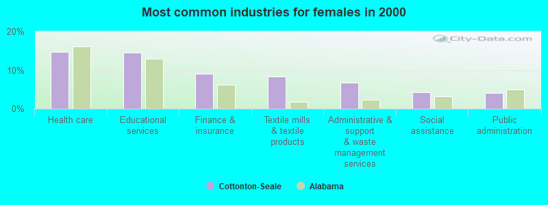
- Health care (14.7%)
- Educational services (14.6%)
- Finance & insurance (8.9%)
- Textile mills & textile products (8.3%)
- Administrative & support & waste management services (6.8%)
- Social assistance (4.3%)
- Public administration (4.1%)
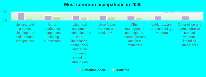
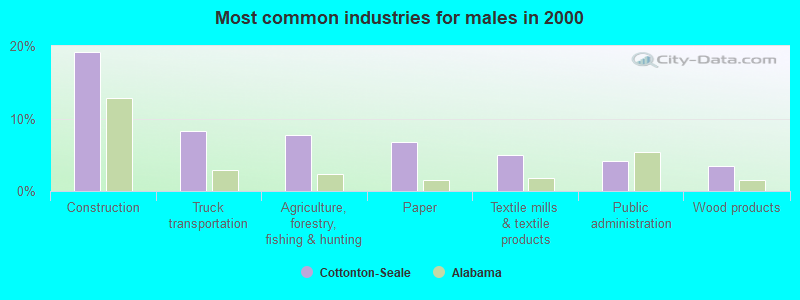
- Building and grounds cleaning and maintenance occupations (7.5%)
- Other production occupations, including supervisors (4.7%)
- Electrical equipment mechanics and other installation, maintenance, and repair workers, including supervisors (4.3%)
- Driver/sales workers and truck drivers (4.2%)
- Other management occupations, except farmers and farm managers (3.9%)
- Textile, apparel, and furnishings workers (3.9%)
- Other office and administrative support workers, including supervisors (3.8%)
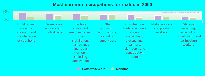
- Building and grounds cleaning and maintenance occupations (8.5%)
- Driver/sales workers and truck drivers (7.1%)
- Electrical equipment mechanics and other installation, maintenance, and repair workers, including supervisors (6.9%)
- Other production occupations, including supervisors (6.6%)
- Construction traders workers except carpenters, electricians, painters, plumbers, and construction laborers (6.5%)
- Metal workers and plastic workers (5.6%)
- Material recording, scheduling, dispatching, and distributing workers (4.1%)
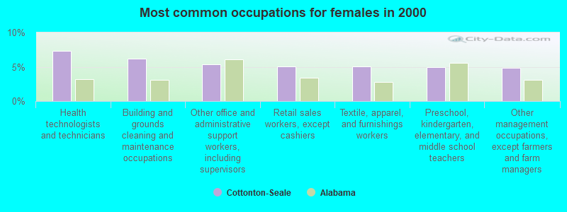
- Health technologists and technicians (7.3%)
- Building and grounds cleaning and maintenance occupations (6.1%)
- Other office and administrative support workers, including supervisors (5.3%)
- Retail sales workers, except cashiers (5.1%)
- Textile, apparel, and furnishings workers (5.1%)
- Preschool, kindergarten, elementary, and middle school teachers (4.9%)
- Other management occupations, except farmers and farm managers (4.8%)
Average climate in Cottonton-Seale, Alabama
Based on data reported by over 4,000 weather stations


(lower is better)
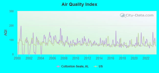
Air Quality Index (AQI) level in 2023 was 86.5. This is about average.
| City: | 86.5 |
| U.S.: | 72.6 |
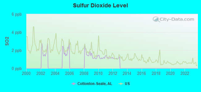
Sulfur Dioxide (SO2) [ppb] level in 2012 was 1.11. This is better than average. Closest monitor was 17.0 miles away from the city center.
| City: | 1.11 |
| U.S.: | 1.51 |
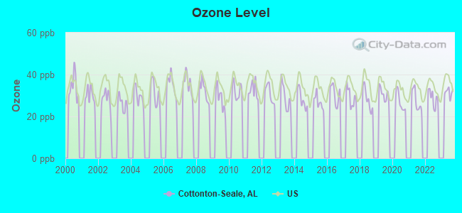
Ozone [ppb] level in 2023 was 31.5. This is about average. Closest monitor was 17.0 miles away from the city center.
| City: | 31.5 |
| U.S.: | 33.3 |
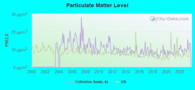
Particulate Matter (PM2.5) [µg/m3] level in 2023 was 11.4. This is significantly worse than average. Closest monitor was 17.6 miles away from the city center.
| City: | 11.4 |
| U.S.: | 8.1 |
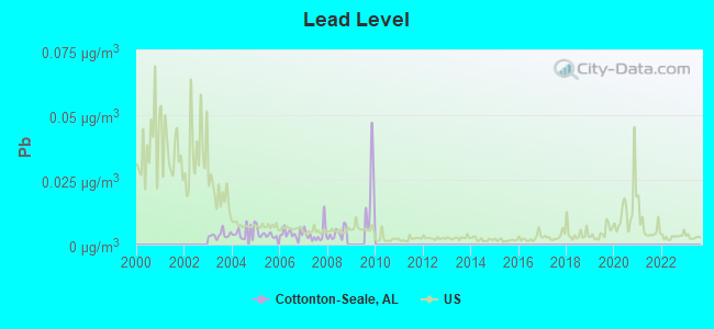
Lead (Pb) [µg/m3] level in 2008 was 0.00433. This is significantly better than average. Closest monitor was 18.2 miles away from the city center.
| City: | 0.00433 |
| U.S.: | 0.00931 |
Tornado activity:
Cottonton-Seale-area historical tornado activity is slightly below Alabama state average. It is 38% greater than the overall U.S. average.
On 3/13/1954, a category F3 (max. wind speeds 158-206 mph) tornado 9.2 miles away from the Cottonton-Seale place center killed 2 people and injured 20 people and caused between $5,000,000 and $50,000,000 in damages.
On 4/1/1981, a category F3 tornado 15.0 miles away from the place center killed 2 people and injured 23 people and caused between $5,000,000 and $50,000,000 in damages.
Earthquake activity:
Cottonton-Seale-area historical earthquake activity is significantly above Alabama state average. It is 30% greater than the overall U.S. average.On 10/24/1997 at 08:35:17, a magnitude 4.9 (4.8 MB, 4.2 MS, 4.9 LG, Depth: 6.2 mi, Class: Light, Intensity: IV - V) earthquake occurred 147.5 miles away from the city center
On 4/29/2003 at 08:59:39, a magnitude 4.9 (4.4 MB, 4.6 MW, 4.9 LG) earthquake occurred 159.7 miles away from Cottonton-Seale center
On 1/18/1999 at 07:00:53, a magnitude 4.8 (4.8 MB, 4.0 LG, Depth: 0.6 mi) earthquake occurred 148.3 miles away from the city center
On 8/2/1974 at 08:52:09, a magnitude 4.9 (4.3 MB, 4.9 LG) earthquake occurred 190.7 miles away from Cottonton-Seale center
On 4/29/2003 at 08:59:39, a magnitude 4.6 (4.6 MW, Depth: 12.3 mi) earthquake occurred 159.7 miles away from the city center
On 6/24/1975 at 11:11:36, a magnitude 4.5 (4.5 MB) earthquake occurred 188.4 miles away from Cottonton-Seale center
Magnitude types: regional Lg-wave magnitude (LG), body-wave magnitude (MB), surface-wave magnitude (MS), moment magnitude (MW)
Natural disasters:
The number of natural disasters in Russell County (18) is near the US average (15).Major Disasters (Presidential) Declared: 12
Emergencies Declared: 5
Causes of natural disasters: Storms: 10, Floods: 9, Tornadoes: 8, Hurricanes: 5, Winds: 3, Drought: 1, Snowfall: 1, Tropical Storm: 1, Winter Storm: 1, Other: 1 (Note: some incidents may be assigned to more than one category).
Colleges/universities with over 2000 students nearest to Cottonton-Seale:
- Columbus Technical College (about 22 miles; Columbus, GA; Full-time enrollment: 3,241)
- Columbus State University (about 23 miles; Columbus, GA; FT enrollment: 6,876)
- Auburn University (about 34 miles; Auburn University, AL; FT enrollment: 22,741)
- Tuskegee University (about 38 miles; Tuskegee, AL; FT enrollment: 2,810)
- Georgia Southwestern State University (about 55 miles; Americus, GA; FT enrollment: 2,689)
- Troy University (about 57 miles; Troy, AL; FT enrollment: 16,148)
- Auburn University at Montgomery (about 63 miles; Montgomery, AL; FT enrollment: 4,092)
Public high schools in Cottonton-Seale:
- RUSSELL CO HIGH SCH (Students: 1, Location: 4699 OLD SEALE HIGHWAY, Grades: 9-12)
- ALT LEARNING CTR (Location: 91 POORHOUSE RD, Grades: 5-12)
Private high school in Cottonton-Seale:
Public elementary/middle schools in Cottonton-Seale:
- RUSSELL CO MIDDLE SCH (Students: 524, Location: 4716 OLD SEALE HIGHWAY, Grades: 7-8)
- OLIVER ELEM SCH (Location: 77 LONGVIEW STREET, Grades: KG-6)
Points of interest:
Notable locations in Cottonton-Seale: Mahrt (A), Cottonton Volunteer Fire Department Station 1 (B), Pittsview Volunteer Fire Department (C), Cottonton Volunteer Fire Department Station 2 (D), Seale Volunteer Fire Department (E). Display/hide their locations on the map
Churches in Cottonton-Seale include: Mount Moriah Church (A), Mount Olive Church (B), Providence Baptist Church (C), New Hope Church (D), Mount Lebanon Baptist Church (E), Ross Chapel (F), Saint Johns Church (G), Saint Peters Church (H), Shady Grove Church (I). Display/hide their locations on the map
Cemeteries: Thomas Cemetery (1), Cotton Cemetery (2), Porter Cemetery (3), Ivey Cemetery (4), Pittsview Cemetery (5), Key Cemetery (6), Glennville Cemetery (7). Display/hide their locations on the map
Reservoirs: Burts Lake (A), Newsoms Pond (B), Monte Pond (C), Mullin Lake (D), Lonesome Duck Lake (E), Lake Lenora (F), McCann Lake (G), Comers Pond (H). Display/hide their locations on the map
Streams, rivers, and creeks: Silver Run (A), Schoolhouse Branch (B), Sand Branch (C), Hatchechubbee Creek (D), Mitchell Creek (E), Padgett Branch (F), Porter Branch (G), Rocky Creek (H), Mink Creek (I). Display/hide their locations on the map
Parks in Cottonton-Seale include: Glenville Historic District (1), Hatchechubbee Creek Park (2), Briar Creek Park (3), Bluff Creek Access Area (4). Display/hide their locations on the map
| This place: | 2.5 people |
| Alabama: | 2.5 people |
| This place: | 70.5% |
| Whole state: | 67.8% |
| This place: | 4.1% |
| Whole state: | 4.7% |
Likely homosexual households (counted as self-reported same-sex unmarried-partner households)
- Lesbian couples: 0.1% of all households
- Gay men: 0.3% of all households
| This place: | 18.1% |
| Whole state: | 16.1% |
| This place: | 9.8% |
| Whole state: | 7.3% |
13 people in religious group quarters in 2000
For population 15 years and over in Cottonton-Seale:
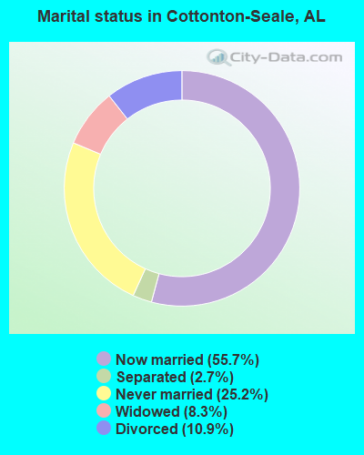
- Never married: 25.2%
- Now married: 55.7%
- Separated: 2.7%
- Widowed: 8.3%
- Divorced: 10.9%
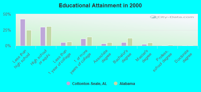
For population 25 years and over in Cottonton-Seale:
- High school or higher: 57.7%
- Bachelor's degree or higher: 8.5%
- Graduate or professional degree: 3.2%
- Unemployed: 8.3%
- Mean travel time to work (commute): 32.9 minutes
| Here: | 14.8 |
| Alabama average: | 13.2 |
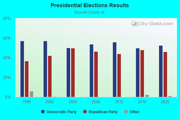
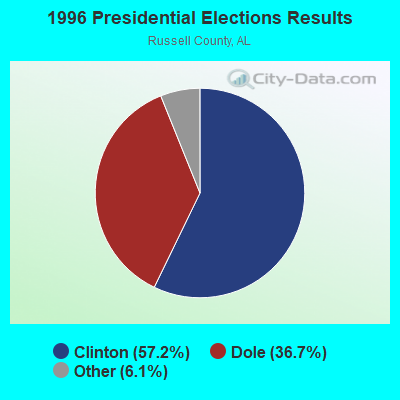
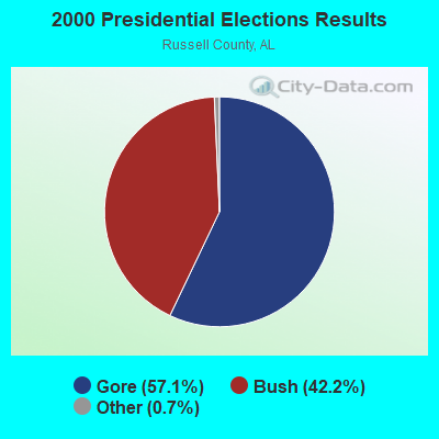
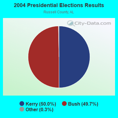
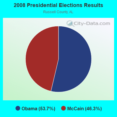
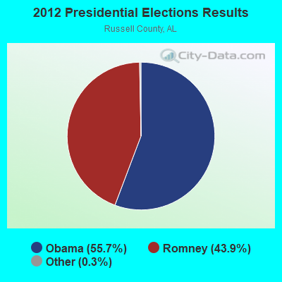
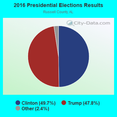
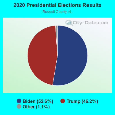
Graphs represent county-level data. Detailed 2008 Election Results
Religion statistics for Cottonton-Seale, AL (based on Russell County data)
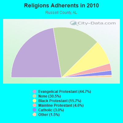
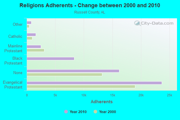
| Religion | Adherents | Congregations |
|---|---|---|
| Evangelical Protestant | 23,650 | 74 |
| Black Protestant | 8,303 | 38 |
| Mainline Protestant | 2,444 | 14 |
| Catholic | 1,595 | 4 |
| Other | 798 | 3 |
| None | 16,157 | - |
Food Environment Statistics:
| Russell County: | 2.59 / 10,000 pop. |
| Alabama: | 1.89 / 10,000 pop. |
| Russell County: | 0.20 / 10,000 pop. |
| Alabama: | 0.20 / 10,000 pop. |
| Here: | 0.40 / 10,000 pop. |
| State: | 0.65 / 10,000 pop. |
| Russell County: | 7.37 / 10,000 pop. |
| State: | 6.32 / 10,000 pop. |
| Russell County: | 4.78 / 10,000 pop. |
| Alabama: | 5.75 / 10,000 pop. |
| This county: | 12.9% |
| Alabama: | 11.8% |
| Here: | 34.8% |
| Alabama: | 31.7% |
| This county: | 11.2% |
| State: | 13.5% |
12.40% of this county's 2021 resident taxpayers lived in other counties in 2020 ($38,710 average adjusted gross income)
| Here: | 12.40% |
| Alabama average: | 6.87% |
0.13% of residents moved from foreign countries ($560 average AGI)
Russell County: 0.13% Alabama average: 0.02%
Top counties from which taxpayers relocated into this county between 2020 and 2021:
| from Muscogee County, GA | |
| from Lee County, AL | |
| from Chattahoochee County, GA |
Strongest AM radio stations in Cottonton-Seale:
- WDAK (540 AM; 5 kW; COLUMBUS, GA; Owner: CLEAR CHANNEL BROADCASTING LICENSES, INC.)
- WMLF (1270 AM; 5 kW; COLUMBUS, GA; Owner: CLEAR CHANNEL BROADCASTING LICENSES, INC.)
- WRCG (1420 AM; 5 kW; COLUMBUS, GA; Owner: ABG GEORGIA, LLC)
- WHAL (1460 AM; 4 kW; PHENIX CITY/COLUMBUS, AL; Owner: CLEAR CHANNEL BROADCASTING LICENSES, INC.)
- WMAC (940 AM; 50 kW; MACON, GA; Owner: CUMULUS LICENSING CORP.)
- WGST (640 AM; 50 kW; ATLANTA, GA; Owner: CITICASTERS LICENSES, L.P.)
- WEAM (1580 AM; 2 kW; COLUMBUS, GA; Owner: DAVIS BROADCASTING, INC. OF COLUMBUS)
- WKNG (1060 AM; daytime; 50 kW; TALLAPOOSA, GA; Owner: WKNG, INC.)
- WNSI (810 AM; 50 kW; JACKSONVILLE, AL; Owner: UNITED BROADCASTING NETWORK, INC.)
- WSB (750 AM; 50 kW; ATLANTA, GA; Owner: CXR HOLDINGS, INC.)
- WCNN (680 AM; 50 kW; NORTH ATLANTA, GA; Owner: DICKEY BROADCASTING COMPANY)
- WGUN (1010 AM; 50 kW; ATLANTA, GA; Owner: WGUN, INC.)
- WJOX (690 AM; 50 kW; BIRMINGHAM, AL; Owner: CITADEL BROADCASTING COMPANY)
Strongest FM radio stations in Cottonton-Seale:
- WKCN (99.3 FM; LUMPKIN, GA; Owner: ABG GEORGIA, LLC)
- WCGQ (107.3 FM; COLUMBUS, GA; Owner: ABG GEORGIA, LLC)
- WAGH (98.3 FM; FORT MITCHELL, AL; Owner: CLEAR CHANNEL BROADCASTING LICENSES, INC.)
- WBFA (101.3 FM; SMITHS, AL; Owner: CLEAR CHANNEL BROADCASTING LICENSES, INC.)
- WIOL (92.7 FM; EUFAULA, AL; Owner: HATCHEE CREEK COMMUNICATIONS, INC.)
- WVFJ-FM (93.3 FM; MANCHESTER, GA; Owner: PROVIDENT BROADCASTING COMPANY)
- WMXA (96.7 FM; OPELIKA, AL; Owner: QANTUM OF AUBURN LICENSE COMPANY, LLC)
- WSTH-FM (106.1 FM; ALEXANDER CITY, AL; Owner: CLEAR CHANNEL BROADCASTING LICENSES, INC.)
- WRVX (97.9 FM; EUFAULA, AL; Owner: RIVER VALLEY MEDIA, L.L.C.)
- WFXE (104.9 FM; COLUMBUS, GA; Owner: DAVIS BROADCASTING)
- WEAM-FM (100.7 FM; BUENA VISTA, GA; Owner: DAVIS BROADCASTING INC., OF COLUMBUS)
- WGSY (100.1 FM; PHENIX CITY, AL; Owner: CLEAR CHANNEL BROADCASTING LICENSES, INC.)
- WFRC (90.5 FM; COLUMBUS, GA; Owner: FAMILY STATIONS, INC.)
- W220BI (91.9 FM; EUFAULA, AL; Owner: MONTGOMERY CHRISTIAN EDUC., RADIO)
TV broadcast stations around Cottonton-Seale:
- WTVM (Channel 9; COLUMBUS, GA; Owner: RAYCOM AMERICA, INC.)
- WRBL (Channel 3; COLUMBUS, GA; Owner: MEDIA GENERAL BROADCASTING OF SO. CAROLINA HOLDINGS, INC.)
- WLTZ (Channel 38; COLUMBUS, GA; Owner: LEWIS BROADCASTING CORPORATION)
- WXTX (Channel 54; COLUMBUS, GA; Owner: FISHER BROADCASTING - GEORGIA, L.L.C.)
- WSWS-TV (Channel 66; OPELIKA, AL; Owner: PAPPAS TELECASTING OF OPELIKA)
- WCGT-LP (Channel 16; COLUMBUS, GA; Owner: COLUMBUS TELEVISION, INC.)
- WACS-TV (Channel 25; DAWSON, GA; Owner: GEORGIA PUBLIC TELECOMMUNICATIONS COMMISSION)
- W55CR (Channel 55; ATLANTA, GA; Owner: WORD OF GOD FELLOWSHIP, INC.)
- W06BH (Channel 6; PHENIX CITY, ETC., AL; Owner: GREENE COMMUNICATIONS, INC.)
- WGIQ (Channel 43; LOUISVILLE, AL; Owner: ALABAMA EDUCATIONAL TELEVISION COMMISSION)
- W30BD (Channel 30; EUFAULA, AL; Owner: TRINITY BROADCASTING NETWORK)
- National Bridge Inventory (NBI) Statistics
- 14Number of bridges
- 148ft / 45.3mTotal length
- $18,503,000Total costs
- 52,778Total average daily traffic
- 7,694Total average daily truck traffic
- 80,770Total future (year 2028) average daily traffic
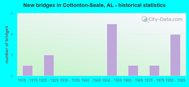
- New bridges - historical statistics
- 11910-1919
- 21920-1929
- 51950-1959
- 11960-1969
- 11970-1979
- 41980-1989
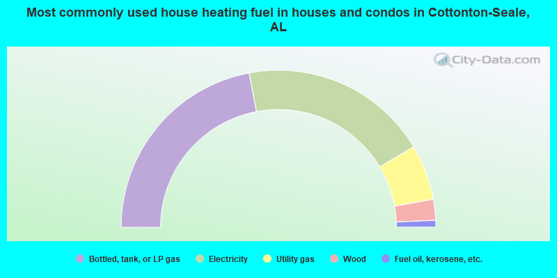
- 44.0%Bottled, tank, or LP gas
- 38.8%Electricity
- 11.4%Utility gas
- 4.3%Wood
- 1.4%Fuel oil, kerosene, etc.
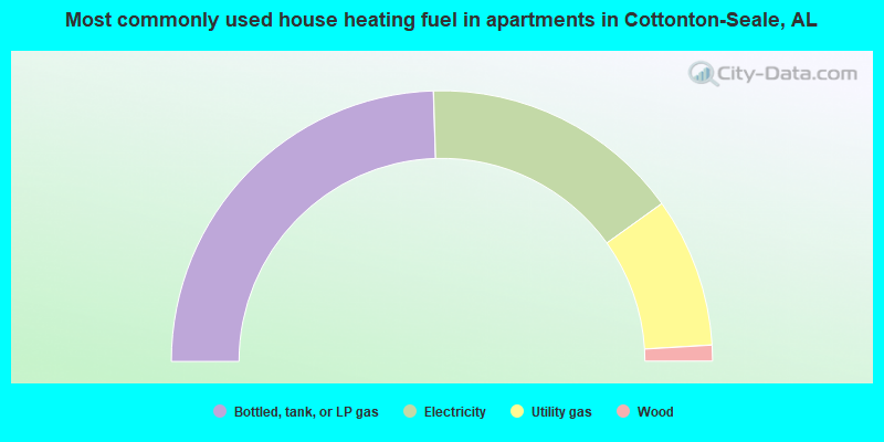
- 49.0%Bottled, tank, or LP gas
- 31.2%Electricity
- 17.9%Utility gas
- 1.9%Wood
Cottonton-Seale compared to Alabama state average:
- Median house value below state average.
- Unemployed percentage below state average.
- Hispanic race population percentage below state average.
- Median age below state average.
- Foreign-born population percentage significantly below state average.
- Renting percentage below state average.
- Length of stay since moving in significantly above state average.
- Number of rooms per house significantly below state average.
- House age significantly below state average.
- Percentage of population with a bachelor's degree or higher significantly below state average.