Crawford, Tennessee
Crawford: The greater Crawford metropolitan area

Crawford: Vine Ridge, Crawford, TN
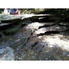
Crawford: Little Indian River, Crawford, TN
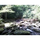
Crawford: Little Indian River, Crawford, TN
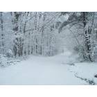
Crawford: Crawford downtown
- add
your
Submit your own pictures of this place and show them to the world
- OSM Map
- General Map
- Google Map
- MSN Map

| Males: 1,247 | |
| Females: 1,256 |
| Median resident age: | 36.8 years |
| Tennessee median age: | 35.9 years |
Zip code: 38554
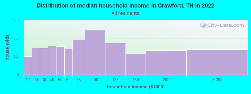
| Crawford: | $41,569 |
| TN: | $65,254 |
Estimated per capita income in 2022: $29,248 (it was $13,516 in 2000)
Crawford CCD income, earnings, and wages data
Estimated median house or condo value in 2022: $136,649 (it was $48,400 in 2000)
| Crawford: | $136,649 |
| TN: | $284,800 |
Mean prices in 2022: all housing units: $249,142; detached houses: $283,431; townhouses or other attached units: $148,685; mobile homes: $79,590
Detailed information about poverty and poor residents in Crawford, TN


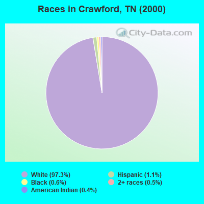
- 2,34797.3%White alone
- 271.1%Hispanic
- 140.6%Black alone
- 130.5%Two or more races
- 100.4%American Indian alone
Races in Crawford detailed stats: ancestries, foreign born residents, place of birth
According to our research of Tennessee and other state lists, there were 2 registered sex offenders living in Crawford, Tennessee as of May 15, 2024.
The ratio of all residents to sex offenders in Crawford is 1,252 to 1.
The ratio of registered sex offenders to all residents in this city is much lower than the state average.
 Recent articles from our blog. Our writers, many of them Ph.D. graduates or candidates, create easy-to-read articles on a wide variety of topics.
Current Local Time: CST time zone
Elevation: 1878 feet
Land area: 106.7 square miles.
Population density: 23 people per square mile (very low).

| Crawford CCD: | 0.4% ($199) |
| Tennessee: | 0.8% ($715) |
Nearest city with pop. 50,000+: Knoxville, TN  (70.6 miles , pop. 173,890).
Nearest city with pop. 200,000+: Nashville-Davidson, TN (89.4 miles , pop. 545,524).
Nearest city with pop. 1,000,000+: Chicago, IL (410.6 miles , pop. 2,896,016).
Nearest cities:
), ), ), )Latitude: 36.23 N, Longitude: 85.16 W
Area code: 931

| Here: | 3.0% |
| Tennessee: | 3.0% |
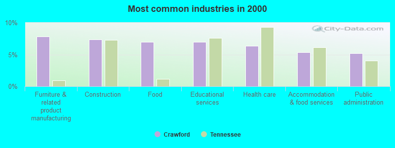
- Furniture & related product manufacturing (7.8%)
- Construction (7.4%)
- Food (7.0%)
- Educational services (7.0%)
- Health care (6.3%)
- Accommodation & food services (5.3%)
- Public administration (5.2%)
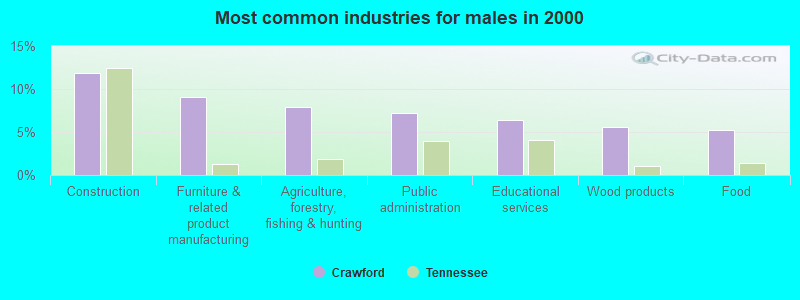
- Construction (11.8%)
- Furniture & related product manufacturing (9.0%)
- Agriculture, forestry, fishing & hunting (7.9%)
- Public administration (7.2%)
- Educational services (6.4%)
- Wood products (5.6%)
- Food (5.2%)
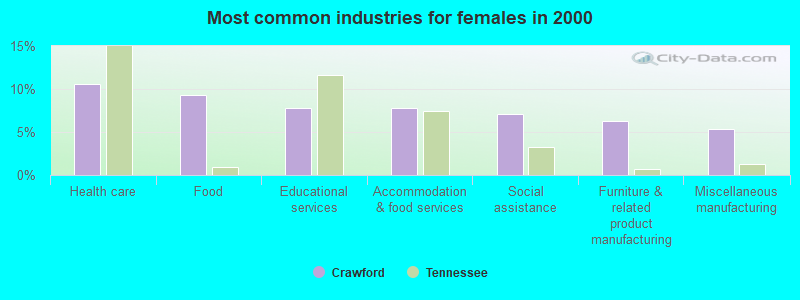
- Health care (10.6%)
- Food (9.3%)
- Educational services (7.8%)
- Accommodation & food services (7.8%)
- Social assistance (7.1%)
- Furniture & related product manufacturing (6.3%)
- Miscellaneous manufacturing (5.4%)
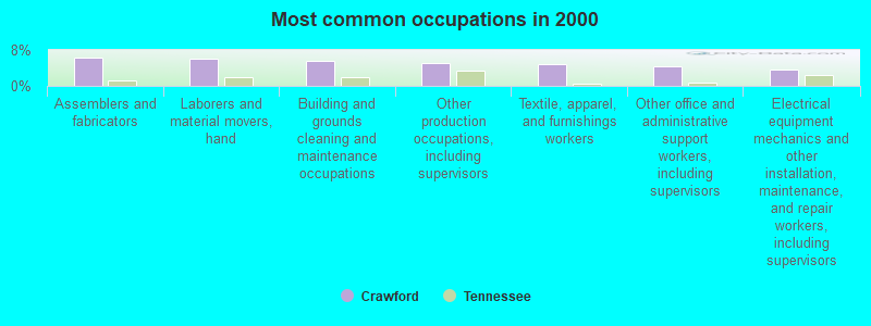
- Assemblers and fabricators (6.2%)
- Laborers and material movers, hand (6.2%)
- Building and grounds cleaning and maintenance occupations (5.6%)
- Other production occupations, including supervisors (5.0%)
- Textile, apparel, and furnishings workers (4.8%)
- Other office and administrative support workers, including supervisors (4.5%)
- Electrical equipment mechanics and other installation, maintenance, and repair workers, including supervisors (3.5%)
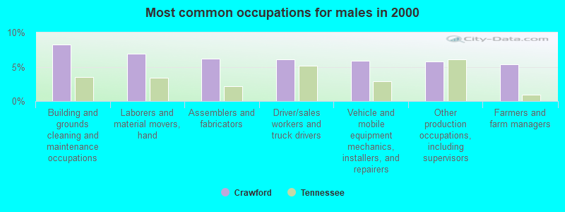
- Building and grounds cleaning and maintenance occupations (8.2%)
- Laborers and material movers, hand (6.9%)
- Assemblers and fabricators (6.2%)
- Driver/sales workers and truck drivers (6.1%)
- Vehicle and mobile equipment mechanics, installers, and repairers (5.9%)
- Other production occupations, including supervisors (5.7%)
- Farmers and farm managers (5.4%)
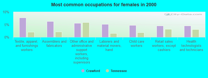
- Textile, apparel, and furnishings workers (7.8%)
- Assemblers and fabricators (6.3%)
- Other office and administrative support workers, including supervisors (5.6%)
- Laborers and material movers, hand (5.2%)
- Child care workers (4.8%)
- Retail sales workers, except cashiers (4.5%)
- Health technologists and technicians (4.5%)
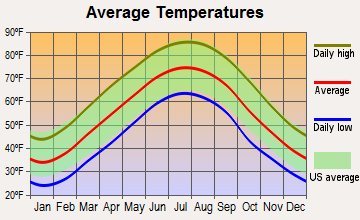
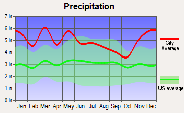
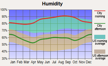
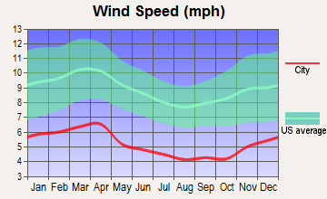
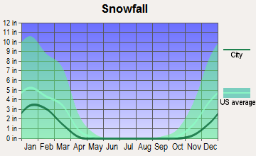
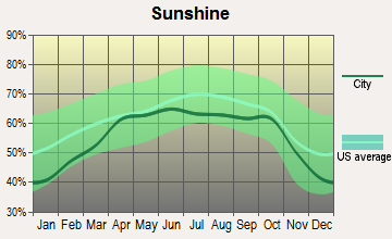
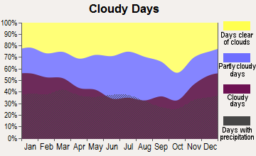
Average climate in Crawford, Tennessee
Based on data reported by over 4,000 weather stations
(lower is better)
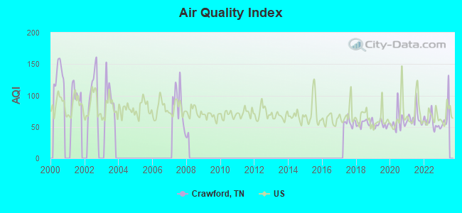
Air Quality Index (AQI) level in 2022 was 56.8. This is better than average.
| City: | 56.8 |
| U.S.: | 72.6 |
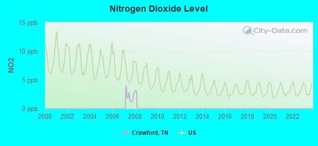
Nitrogen Dioxide (NO2) [ppb] level in 2007 was 2.13. This is significantly better than average. Closest monitor was 13.3 miles away from the city center.
| City: | 2.13 |
| U.S.: | 5.11 |
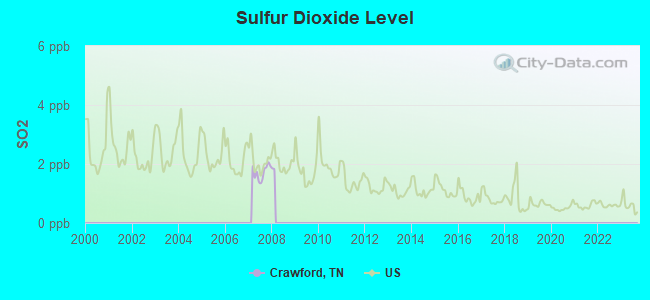
Sulfur Dioxide (SO2) [ppb] level in 2007 was 1.72. This is about average. Closest monitor was 13.3 miles away from the city center.
| City: | 1.72 |
| U.S.: | 1.51 |
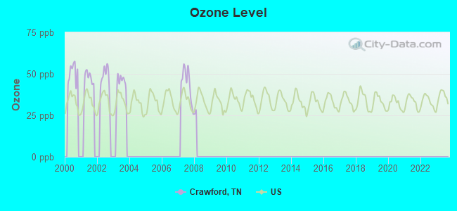
Ozone [ppb] level in 2007 was 44.0. This is worse than average. Closest monitor was 13.3 miles away from the city center.
| City: | 44.0 |
| U.S.: | 33.3 |
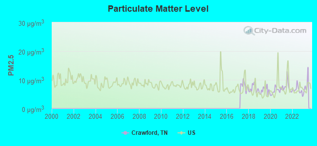
Particulate Matter (PM2.5) [µg/m3] level in 2022 was 6.46. This is better than average. Closest monitor was 18.6 miles away from the city center.
| City: | 6.46 |
| U.S.: | 8.11 |
Tornado activity:
Crawford-area historical tornado activity is near Tennessee state average. It is 31% greater than the overall U.S. average.
On 4/3/1974, a category F4 (max. wind speeds 207-260 mph) tornado 2.2 miles away from the Crawford place center killed 10 people and injured 51 people and caused between $500,000 and $5,000,000 in damages.
On 4/3/1974, a category F4 tornado 4.8 miles away from the place center killed 7 people and injured 150 people and caused between $500,000 and $5,000,000 in damages.
Earthquake activity:
Crawford-area historical earthquake activity is significantly above Tennessee state average. It is 121% greater than the overall U.S. average.On 7/27/1980 at 18:52:21, a magnitude 5.2 (5.1 MB, 4.7 MS, 5.0 UK, 5.2 UK, Class: Moderate, Intensity: VI - VII) earthquake occurred 152.0 miles away from Crawford center
On 4/18/2008 at 09:36:59, a magnitude 5.4 (5.1 MB, 4.8 MS, 5.4 MW, 5.2 MW) earthquake occurred 214.3 miles away from the city center
On 11/30/1973 at 07:48:41, a magnitude 4.7 (4.7 MB, 4.6 ML, Class: Light, Intensity: IV - V) earthquake occurred 73.7 miles away from the city center
On 4/29/2003 at 08:59:39, a magnitude 4.9 (4.4 MB, 4.6 MW, 4.9 LG) earthquake occurred 123.2 miles away from the city center
On 12/12/2018 at 09:14:43, a magnitude 4.4 (4.4 MW, Depth: 4.9 mi) earthquake occurred 49.4 miles away from Crawford center
On 4/18/2008 at 09:36:59, a magnitude 5.2 (5.2 MW, Depth: 8.9 mi) earthquake occurred 214.3 miles away from the city center
Magnitude types: regional Lg-wave magnitude (LG), body-wave magnitude (MB), local magnitude (ML), surface-wave magnitude (MS), moment magnitude (MW)
Natural disasters:
The number of natural disasters in Overton County (15) is near the US average (15).Major Disasters (Presidential) Declared: 11
Emergencies Declared: 2
Causes of natural disasters: Floods: 10, Storms: 9, Winter Storms: 3, Tornadoes: 2, Flash Flood: 1, Hurricane: 1, Ice Storm: 1, Landslide: 1, Mudslide: 1, Snowfall: 1, Wind: 1, Other: 1 (Note: some incidents may be assigned to more than one category).
Hospitals and medical centers near Crawford:
- INTREPID USA HEALTHCARE SERVICES (Home Health Center, about 9 miles away; MONTEREY, TN)
- STANDING STONE CARE AND REHAB (Nursing Home, about 9 miles away; MONTEREY, TN)
- STANDING STONE HEALTH CARE CENTER (Nursing Home, about 9 miles away; MONTEREY, TN)
- AMEDISYS (Home Health Center, about 14 miles away; LIVINGSTON, TN)
- LIVINGSTON TN DIALYSIS (Dialysis Facility, about 14 miles away; LIVINGSTON, TN)
- LIVINGSTON REGIONAL HOSPITAL Acute Care Hospitals (about 14 miles away; LIVINGSTON, TN)
- OVERTON COUNTY NURSING HOME (Nursing Home, about 15 miles away; LIVINGSTON, TN)
Colleges/universities with over 2000 students nearest to Crawford:
- Tennessee Technological University (about 20 miles; Cookeville, TN; Full-time enrollment: 9,761)
- Roane State Community College (about 39 miles; Harriman, TN; FT enrollment: 4,302)
- Pellissippi State Community College (about 60 miles; Knoxville, TN; FT enrollment: 7,271)
- Lindsey Wilson College (about 61 miles; Columbia, KY; FT enrollment: 2,552)
- Somerset Community College (about 65 miles; Somerset, KY; FT enrollment: 4,698)
- University of the Cumberlands (about 66 miles; Williamsburg, KY; FT enrollment: 3,585)
- The University of Tennessee-Knoxville (about 72 miles; Knoxville, TN; FT enrollment: 25,483)
Public elementary/middle school in Crawford:
- WILSON ELEMENTARY (Students: 218, Location: 2210 HANGING LIMB HW, Grades: PK-8)
Points of interest:
Notable locations in Crawford: Doubling Spur (A), Dry Hollow Volunteer Fire Department (B), Muddy Pond Volunteer Fire Department (C), Mountain Volunteer Fire and Rescue (D). Display/hide their locations on the map
Churches in Crawford include: Hanging Limb Baptist Church (A), Union Grove Church (B), Union Point Church (C), Three Forks Church (D), Columbia Hill Church (E), Pine Ridge Church (F), Vine Ridge Baptist Church (G), Mineral Springs First Baptist Church (H). Display/hide their locations on the map
Cemeteries: Swallows Cemetery (1), Walker Cemetery (2), Wilson Cemetery (3), Union Point Cemetery (4), Pine Ridge Cemetery (5), Muddy Pond Cemetery (6), Lovejoy Cemetery (7). Display/hide their locations on the map
Reservoirs: Camp Monterey Lake (A), Lad Lake (B), Pine Ridge Lake (C). Display/hide their locations on the map
Streams, rivers, and creeks: Looper Branch (A), Long Branch (B), Little Indian Creek (C), Lick Branch (D), Jack Branch (E), Fond Branch (F), Flintrock Branch (G), Dry Branch (H), Dennis Branch (I). Display/hide their locations on the map
| This place: | 2.6 people |
| Tennessee: | 2.5 people |
| This place: | 71.8% |
| Whole state: | 69.8% |
| This place: | 3.0% |
| Whole state: | 4.2% |
Likely homosexual households (counted as self-reported same-sex unmarried-partner households)
- Lesbian couples: 0.2% of all households
- Gay men: 0.1% of all households
| This place: | 21.8% |
| Whole state: | 13.5% |
| This place: | 8.4% |
| Whole state: | 5.8% |
For population 15 years and over in Crawford:
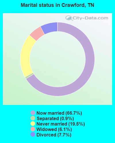
- Never married: 19.5%
- Now married: 66.7%
- Separated: 0.9%
- Widowed: 6.1%
- Divorced: 7.7%
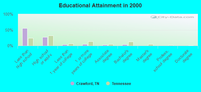
For population 25 years and over in Crawford:
- High school or higher: 44.4%
- Bachelor's degree or higher: 5.1%
- Graduate or professional degree: 0.8%
- Unemployed: 2.6%
- Mean travel time to work (commute): 35.9 minutes
| Here: | 18.4 |
| Tennessee average: | 13.3 |
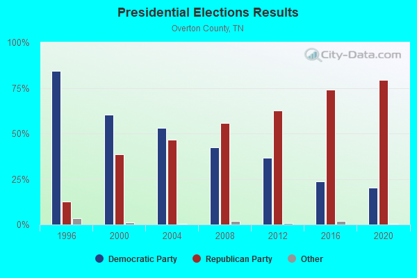
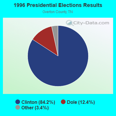
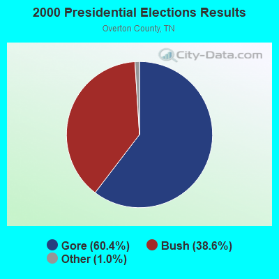

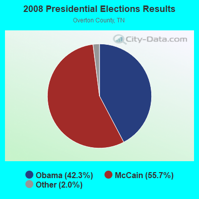
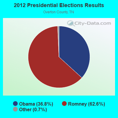
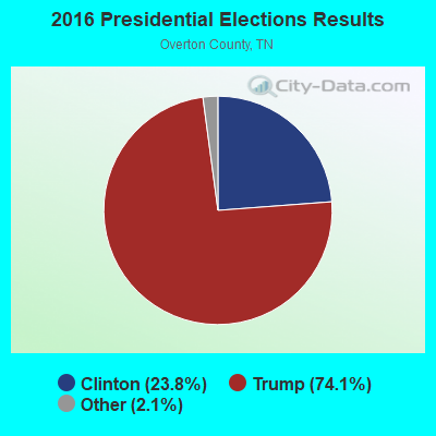
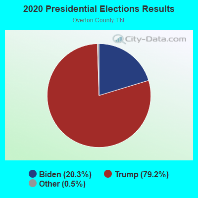
Graphs represent county-level data. Detailed 2008 Election Results
Religion statistics for Crawford, TN (based on Overton County data)
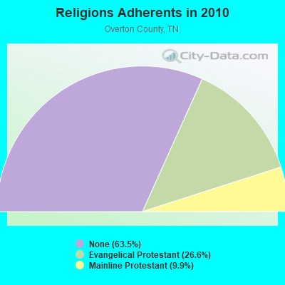
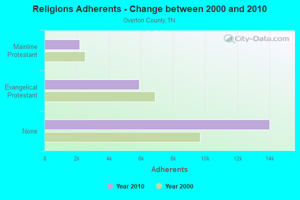
| Religion | Adherents | Congregations |
|---|---|---|
| Evangelical Protestant | 5,879 | 40 |
| Mainline Protestant | 2,189 | 18 |
| Catholic | - | - |
| Other | - | 2 |
| None | 14,015 | - |
Food Environment Statistics:
| This county: | 3.34 / 10,000 pop. |
| Tennessee: | 1.99 / 10,000 pop. |
| Here: | 6.20 / 10,000 pop. |
| Tennessee: | 5.16 / 10,000 pop. |
| Here: | 4.30 / 10,000 pop. |
| Tennessee: | 6.56 / 10,000 pop. |
| Overton County: | 11.9% |
| Tennessee: | 11.4% |
| Overton County: | 28.9% |
| Tennessee: | 30.2% |
| Here: | 14.6% |
| State: | 13.5% |
Strongest AM radio stations in Crawford:
- WKVL (850 AM; daytime; 50 kW; KNOXVILLE, TN; Owner: HORNE RADIO, LLC)
- WSM (650 AM; 50 kW; NASHVILLE, TN; Owner: GAYLORD ENTERTAINMENT COMPANY)
- WWAM (820 AM; daytime; 50 kW; JASPER, TN; Owner: SHELTON BROADCASTING SYSTEM)
- WLIV (920 AM; 1 kW; LIVINGSTON, TN; Owner: SUNNY BROADCASTING, L.L.C.)
- WFLI (1070 AM; 50 kW; LOOKOUT MOUNTAIN, TN; Owner: WFLI, INC.)
- WAMB (1160 AM; 50 kW; DONELSON, TN; Owner: GREAT SOUTHERN BROADCASTING COMPANY, INC.)
- WATX (1590 AM; 2 kW; ALGOOD, TN; Owner: JWC BROADCASTING)
- WECO (940 AM; 5 kW; WARTBURG, TN; Owner: MORGAN COUNTY B/CASTING CO.)
- WKDA (1200 AM; 50 kW; NASHVILLE, TN; Owner: RADIO NASHVILLE, INC.)
- WLAC (1510 AM; 50 kW; NASHVILLE, TN; Owner: CAPSTAR TX LIMITED PARTNERSHIP)
- WNQM (1300 AM; 50 kW; NASHVILLE, TN; Owner: WNQM. INC.)
- WHAS (840 AM; 50 kW; LOUISVILLE, KY; Owner: CLEAR CHANNEL BROADCASTING LICENSES, INC.)
- WPTN (780 AM; daytime; 1 kW; COOKEVILLE, TN; Owner: CLEAR CHANNEL BROADCASTING LICENSES, INC.)
Strongest FM radio stations in Crawford:
- WLIV-FM (104.7 FM; MONTEREY, TN; Owner: WKXN INC)
- WGSQ (94.7 FM; COOKEVILLE, TN; Owner: CLEAR CHANNEL BROADCASTING LICENSES, INC.)
- WKXD-FM (106.9 FM; MONTEREY, TN; Owner: JWC BROADCASTING)
- WLQK (95.9 FM; LIVINGSTON, TN; Owner: JWC BROADCASTING)
- WWOG (90.9 FM; COOKEVILLE, TN; Owner: SOMERSET EDUCATIONAL BROADCASTING FOUNDATION)
- WOWF (102.5 FM; CROSSVILLE, TN; Owner: PEG BROADCASTING, INC.)
- WCLC-FM (105.1 FM; JAMESTOWN, TN; Owner: BIBLE BELIEVERS NETWORK, INC.)
- WMKW (89.3 FM; CROSSVILLE, TN; Owner: THE MOODY BIBLE INSTITUTE OF CHICAGO)
- WBXE (93.7 FM; BAXTER, TN; Owner: JWC BROADCASTING)
- WGIC (98.5 FM; COOKEVILLE, TN; Owner: CLEAR CHANNEL BROADCASTING LICENSES, INC.)
- WDVX (89.9 FM; CLINTON, TN; Owner: CUMBERLAND COMMUNITIES COMMUNI CORP.)
- WWSR (105.7 FM; ROCKWOOD, TN; Owner: SOUTHERN MEDIA GROUP, INC.)
- WDEB-FM (103.9 FM; JAMESTOWN, TN; Owner: BAZ BROADCASTING, INC.)
- W206AJ (89.1 FM; COOKEVILLE, TN; Owner: WAY-FM MEDIA GROUP, INC.)
- WECO-FM (101.3 FM; WARTBURG, TN; Owner: MORGAN COUNTY BROADCASTING CO., INC.)
- WHRS (91.7 FM; COOKEVILLE, TN; Owner: NASHVILLE PUBLIC RADIO)
- WRKK-FM (105.5 FM; SPARTA, TN; Owner: CLEAR CHANNEL BROADCASTING LICENSES, INC.)
- WXVL (99.3 FM; CROSSVILLE, TN; Owner: CLEAR CHANNEL BROADCASTING LICENSES, INC.)
TV broadcast stations around Crawford:
- WCTE (Channel 22; COOKEVILLE, TN; Owner: UPPER CUMBERLAND BROADCAST COUNCIL)
- WBXX-TV (Channel 20; CROSSVILLE, TN; Owner: ACME TV LICENSES OF TENNESSEE, LLC)
- W57CZ (Channel 57; COOKEVILLE, TN; Owner: TRINITY BROADCASTING NETWORK)
FCC Registered Amateur Radio Licenses:
4- Call Sign: KF4GRU, Licensee ID: L01092603, Grant Date: 03/01/2016, Expiration Date: 02/10/2026, Certifier: William B Burn, Registrant: William B Burn, 415 Bear Knob Ln, Crawford, TN 38554-3454
- Call Sign: W2BY, Previous Call Sign: N2DXO, Licensee ID: L01224779, Grant Date: 02/23/2017, Expiration Date: 05/15/2027, Certifier: J Michael Drake, Registrant: J Michael Drake, 651 Bear Knob Ln, Crawford, TN 38554
- Call Sign: KK6CXS, Licensee ID: L01769884, Grant Date: 03/14/2023, Expiration Date: 03/14/2033, Certifier: Robert Schlabitz, Registrant: Robert Schlabitz, 5675 Hidden Lane, Crawford, TN 38554
- Call Sign: KO4DPN, Licensee ID: L02075602, Grant Date: 05/21/2020, Expiration Date: 05/21/2030, Certifier: Charles F Cahill, Registrant: Charles F Cahill, Po Box 58, Crawford, TN 38554
2004 - 2018 National Fire Incident Reporting System (NFIRS) incidents
- Fire incident types reported to NFIRS in Crawford, TN
- 8249.1%Outside Fires
- 6941.3%Structure Fires
- 95.4%Mobile Property/Vehicle Fires
- 74.2%Other
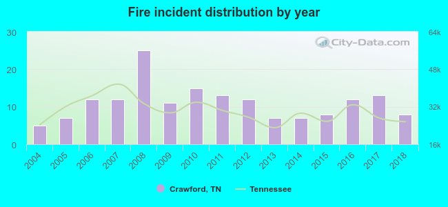 According to the data from the years 2004 - 2018 the average number of fires per year is 11. The highest number of reported fire incidents - 25 took place in 2008, and the least - 5 in 2004. The data has a rising trend.
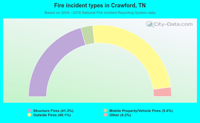 When looking into fire subcategories, the most reports belonged to: Outside Fires (49.1%), and Structure Fires (41.3%).
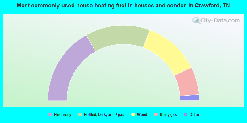
- 33.6%Electricity
- 27.7%Bottled, tank, or LP gas
- 24.2%Wood
- 12.0%Utility gas
- 1.4%Fuel oil, kerosene, etc.
- 1.1%Other fuel
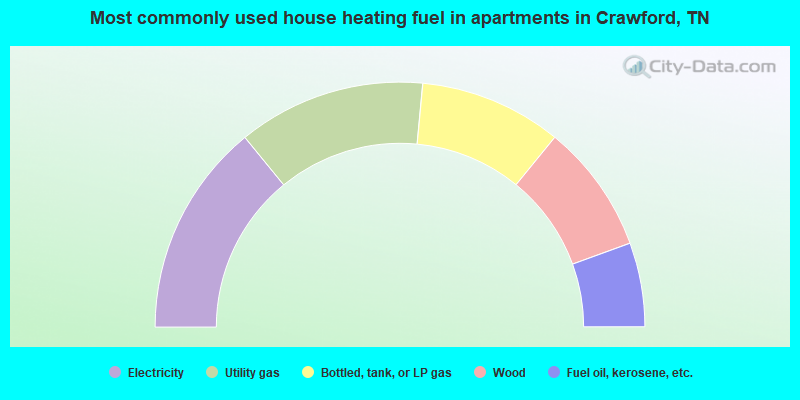
- 28.2%Electricity
- 24.8%Utility gas
- 18.8%Bottled, tank, or LP gas
- 17.1%Wood
- 11.1%Fuel oil, kerosene, etc.
Crawford compared to Tennessee state average:
- Median household income below state average.
- Median house value below state average.
- Unemployed percentage significantly below state average.
- Black race population percentage significantly below state average.
- Hispanic race population percentage significantly below state average.
- Foreign-born population percentage significantly below state average.
- Renting percentage significantly below state average.
- Length of stay since moving in significantly above state average.
- Number of rooms per house significantly below state average.
- House age significantly below state average.
- Number of college students below state average.
- Percentage of population with a bachelor's degree or higher significantly below state average.
State forum archive:
- Tennessee Pages: 2 3 4 5 6 7 8 9 10 11 12 13 14 15 16 17 18 19 20 21 22 23 24 25 26 27 28 29 30 31 32
- Chattanooga Pages: 2 3 4 5 6 7 8 9 10 11 12 13
- Cookeville Pages: 2 3 4 5 6 7 8 9 10 11
- Kingsport - Johnson City - Bristol Pages: 2 3 4 5 6 7 8 9 10 11 12 13 14 15 16 17 18 19
- Knoxville Pages: 2 3 4 5 6 7 8 9 10 11 12 13 14 15 16 17 18 19 20 21 22 23 24 25 26 27 28 29 30 31
- Memphis Pages: 2 3 4 5 6 7 8 9 10 11 12 13 14 15 16 17 18 19 20
- Nashville Pages: 2 3 4 5 6 7 8 9 10 11 12 13 14 15 16 17 18 19 20 21 22 23 24 25 26 27 28 29 30 31 32 33 34 35 36 37 38 39 40 41 42 43 44 45 46 47 48 49 50 51 52 53 54 55 56 57