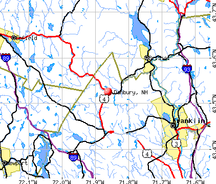
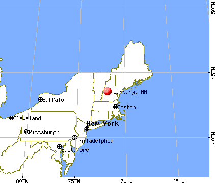
Danbury, New Hampshire
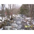
Danbury: Walker Brook
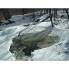
Danbury: The melting of the brook
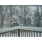
Danbury: Blizzard of 2011
Danbury: Turkeys in our front yard
- add
your
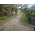
Submit your own pictures of this town and show them to the world
- OSM Map
- General Map
- Google Map
- MSN Map
Population change since 2000: +8.7%
 |
| Males: 592 | |
| Females: 572 |
| Median resident age: | 44.0 years |
| New Hampshire median age: | 43.9 years |
Zip codes: 03230.
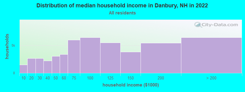
| Danbury: | $66,871 |
| NH: | $89,992 |
Estimated per capita income in 2022: $36,735 (it was $18,339 in 2000)
Danbury town income, earnings, and wages data
Estimated median house or condo value in 2022: $267,568 (it was $85,500 in 2000)
| Danbury: | $267,568 |
| NH: | $384,700 |
Mean prices in 2022: all housing units: $378,901; detached houses: $416,256; townhouses or other attached units: $317,750; in 2-unit structures: $298,869; in 3-to-4-unit structures: $371,619; in 5-or-more-unit structures: $216,601; mobile homes: $110,180; occupied boats, rvs, vans, etc.: $74,347
Detailed information about poverty and poor residents in Danbury, NH


- 1,13697.6%White alone
- 171.5%Hispanic
- 30.3%Asian alone
- 40.3%Two or more races
- 20.2%American Indian alone
- 10.09%Black alone
- 10.09%Other race alone

Races in Danbury detailed stats: ancestries, foreign born residents, place of birth
According to our research of New Hampshire and other state lists, there were 5 registered sex offenders living in Danbury, New Hampshire as of May 28, 2024.
The ratio of all residents to sex offenders in Danbury is 233 to 1.
 Recent articles from our blog. Our writers, many of them Ph.D. graduates or candidates, create easy-to-read articles on a wide variety of topics.

 | Does anyone here live in or have some insight into Canaan and/or Enfield? (12 replies) |
| Freedom, NH - looking for similar towns? (12 replies) |
| Franklin revitalization efforts? (11 replies) |
| Anyone got tales from Hippy Hill? (2 replies) |
| Looking for a safe, affordable neighborhood in NH! (14 replies) |
| Considering moving to Lebanon, NH from TN for Dartmouth...advice? (19 replies) |
Latest news from Danbury, NH collected exclusively by city-data.com from local newspapers, TV, and radio stations
Ancestries: English (19.9%), French (14.9%), Irish (14.9%), German (11.4%), United States (8.4%), Italian (8.0%).
Current Local Time: EST time zone
Incorporated in 1795
Elevation: 825 feet
Land area: 37.4 square miles.
Population density: 31 people per square mile (very low).
13 residents are foreign born
| This town: | 1.2% |
| New Hampshire: | 4.4% |
| Danbury town: | 2.1% ($1,774) |
| New Hampshire: | 2.3% ($2,946) |
Nearest city with pop. 50,000+: Manchester, NH  (42.2 miles , pop. 107,006).
Nearest city with pop. 200,000+: Boston, MA (91.6 miles , pop. 589,141).
Nearest city with pop. 1,000,000+: Bronx, NY (211.3 miles , pop. 1,332,650).
Nearest cities:
), ), Latitude: 43.52 N, Longitude: 71.87 W
Area code: 603

Single-family new house construction building permits:
- 2022: 9 buildings, average cost: $279,200
- 2021: 8 buildings, average cost: $259,200
- 2020: 1 building, cost: $279,000
- 2019: 6 buildings, average cost: $282,200
- 2018: 4 buildings, average cost: $175,000
- 2017: 5 buildings, average cost: $267,800
- 2016: 9 buildings, average cost: $261,800
- 2015: 3 buildings, average cost: $226,800
- 2014: 2 buildings, average cost: $184,000
- 2013: 2 buildings, average cost: $184,000
- 2012: 2 buildings, average cost: $184,000
- 2011: 4 buildings, average cost: $172,800
- 2010: 5 buildings, average cost: $165,900
- 2008: 5 buildings, average cost: $182,400
- 2007: 8 buildings, average cost: $171,000
- 2006: 11 buildings, average cost: $171,000
- 2005: 8 buildings, average cost: $150,200
- 2004: 24 buildings, average cost: $111,600
- 2003: 2 buildings, average cost: $130,700
- 2002: 2 buildings, average cost: $130,700
- 2001: 7 buildings, average cost: $92,900
- 2000: 3 buildings, average cost: $125,000
- 1999: 2 buildings, average cost: $100,000
- 1998: 9 buildings, average cost: $88,900
- 1997: 7 buildings, average cost: $61,100


| Here: | 1.9% |
| New Hampshire: | 2.5% |
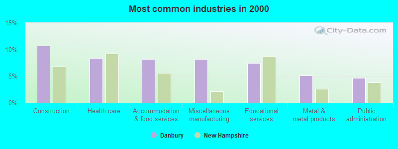
- Construction (10.7%)
- Health care (8.4%)
- Accommodation & food services (8.2%)
- Miscellaneous manufacturing (8.2%)
- Educational services (7.5%)
- Metal & metal products (5.2%)
- Public administration (4.6%)
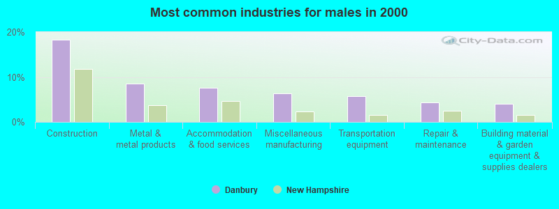
- Construction (18.2%)
- Metal & metal products (8.5%)
- Accommodation & food services (7.5%)
- Miscellaneous manufacturing (6.3%)
- Transportation equipment (5.7%)
- Repair & maintenance (4.4%)
- Building material & garden equipment & supplies dealers (4.1%)
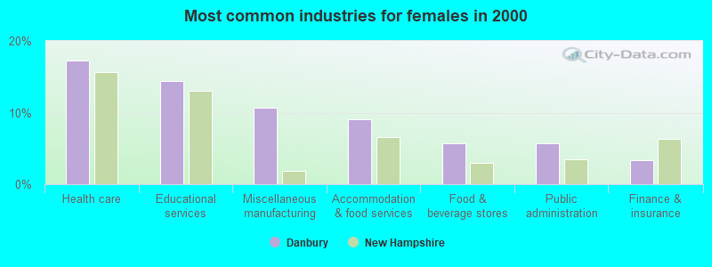
- Health care (17.3%)
- Educational services (14.4%)
- Miscellaneous manufacturing (10.7%)
- Accommodation & food services (9.1%)
- Food & beverage stores (5.8%)
- Public administration (5.8%)
- Finance & insurance (3.3%)

- Other production occupations, including supervisors (6.4%)
- Metal workers and plastic workers (6.1%)
- Building and grounds cleaning and maintenance occupations (4.6%)
- Other management occupations, except farmers and farm managers (3.6%)
- Driver/sales workers and truck drivers (3.4%)
- Material recording, scheduling, dispatching, and distributing workers (3.2%)
- Food and beverage serving workers, except waiters and waitresses (2.9%)

- Other production occupations, including supervisors (6.9%)
- Metal workers and plastic workers (6.9%)
- Driver/sales workers and truck drivers (6.0%)
- Vehicle and mobile equipment mechanics, installers, and repairers (5.0%)
- Carpenters (4.7%)
- Material recording, scheduling, dispatching, and distributing workers (4.4%)
- Other management occupations, except farmers and farm managers (4.1%)

- Building and grounds cleaning and maintenance occupations (7.0%)
- Food and beverage serving workers, except waiters and waitresses (5.8%)
- Other production occupations, including supervisors (5.8%)
- Health technologists and technicians (4.9%)
- Metal workers and plastic workers (4.9%)
- Customer service representatives (4.5%)
- Other sales and related occupations, including supervisors (4.1%)
Average climate in Danbury, New Hampshire
Based on data reported by over 4,000 weather stations


(lower is better)

Air Quality Index (AQI) level in 2022 was 52.4. This is better than average.
| City: | 52.4 |
| U.S.: | 72.6 |

Ozone [ppb] level in 2022 was 26.5. This is better than average. Closest monitor was 19.0 miles away from the city center.
| City: | 26.5 |
| U.S.: | 33.3 |

Particulate Matter (PM2.5) [µg/m3] level in 2022 was 4.93. This is significantly better than average. Closest monitor was 16.8 miles away from the city center.
| City: | 4.93 |
| U.S.: | 8.11 |
Tornado activity:
Danbury-area historical tornado activity is near New Hampshire state average. It is 57% smaller than the overall U.S. average.
On 5/11/1973, a category F2 (max. wind speeds 113-157 mph) tornado 5.5 miles away from the Danbury town center .
On 7/3/1972, a category F2 tornado 23.0 miles away from the town center injured 7 people and caused between $5000 and $50,000 in damages.
Earthquake activity:
Danbury-area historical earthquake activity is significantly above New Hampshire state average. It is 71% smaller than the overall U.S. average.On 4/20/2002 at 10:50:47, a magnitude 5.3 (5.3 ML, Depth: 3.0 mi, Class: Moderate, Intensity: VI - VII) earthquake occurred 114.1 miles away from the city center
On 10/7/1983 at 10:18:46, a magnitude 5.3 (5.1 MB, 5.3 LG, 5.1 ML) earthquake occurred 127.2 miles away from Danbury center
On 4/20/2002 at 10:50:47, a magnitude 5.2 (5.2 MB, 4.2 MS, 5.2 MW, 5.0 MW) earthquake occurred 113.9 miles away from Danbury center
On 1/19/1982 at 00:14:42, a magnitude 4.7 (4.5 MB, 4.7 MD, 4.5 LG, Class: Light, Intensity: IV - V) earthquake occurred 13.5 miles away from the city center
On 10/16/2012 at 23:12:25, a magnitude 4.7 (4.7 ML, Depth: 10.0 mi) earthquake occurred 61.1 miles away from Danbury center
On 8/21/1996 at 07:54:14, a magnitude 3.8 (3.8 LG, 3.6 LG, Depth: 6.2 mi, Class: Light, Intensity: II - III) earthquake occurred 52.9 miles away from the city center
Magnitude types: regional Lg-wave magnitude (LG), body-wave magnitude (MB), duration magnitude (MD), local magnitude (ML), surface-wave magnitude (MS), moment magnitude (MW)
Natural disasters:
The number of natural disasters in Merrimack County (27) is a lot greater than the US average (15).Major Disasters (Presidential) Declared: 17
Emergencies Declared: 9
Causes of natural disasters: Storms: 13, Floods: 12, Winter Storms: 4, Snowstorms: 3, Hurricanes: 2, Snows: 2, Blizzard: 1, Ice Storm: 1, Snowfall: 1, Tornado: 1, Tropical Storm: 1, Wind: 1, Other: 1 (Note: some incidents may be assigned to more than one category).
Hospitals and medical centers near Danbury:
- NEWFOUND AREA NURSING ASSN (Home Health Center, about 9 miles away; BRISTOL, NH)
- LAKE SUNAPEE REGION VNA (Home Health Center, about 9 miles away; NEW LONDON, NH)
- NEW LONDON HOSPITAL Critical Access Hospitals (about 10 miles away; NEW LONDON, NH)
- NEW LONDON HOSPITAL ASSOCIATION INC (Hospital, about 10 miles away; NEW LONDON, NH)
- WILLIAM CLOUGH ECU (Nursing Home, about 10 miles away; NEW LONDON, NH)
- MERRILL MANOR NURSING HOME (Nursing Home, about 12 miles away; FRANKLIN, NH)
- MERRILL MANOR ANNEX (Nursing Home, about 12 miles away; FRANKLIN, NH)
Colleges/universities with over 2000 students nearest to Danbury:
- Plymouth State University (about 19 miles; Plymouth, NH; Full-time enrollment: 4,838)
- Dartmouth College (about 25 miles; Hanover, NH; FT enrollment: 6,030)
- NHTI-Concord's Community College (about 27 miles; Concord, NH; FT enrollment: 2,865)
- Southern New Hampshire University (about 39 miles; Manchester, NH; FT enrollment: 16,552)
- Saint Anselm College (about 41 miles; Manchester, NH; FT enrollment: 2,059)
- Mount Washington College (about 43 miles; Manchester, NH; FT enrollment: 2,187)
- Keene State College (about 46 miles; Keene, NH; FT enrollment: 5,098)
Public elementary/middle school in Danbury:
- DANBURY ELEMENTARY SCHOOL (Students: 67, Location: 20 DAFFODIL LN., Grades: KG-5)
Points of interest:
Notable locations in Danbury: Saint Pauls School Camp (A), Ragged Mountain Ski Area (B), Cardigan Camp (C), Danbury Volunteer Fire Department (D). Display/hide their locations on the map
Church in Danbury: Danbury Christian Church (A). Display/hide its location on the map
Cemetery: Riverside Cemetery (1). Display/hide its location on the map
Lakes and reservoirs: School Pond (A), Waukeena Lake (B), Benton Pond (C), Hoyt Brook Pond (D), Bog Pond (E). Display/hide their locations on the map
Streams, rivers, and creeks: Tioga Brook (A), Taylor Brook (B), Wild Meadow Brook (C), Hoyt Brook (D), Gulf Brook (E), Beverly Brook (F), Walker Brook (G). Display/hide their locations on the map
Park in Danbury: Danbury Bog Wildlife Management Area (1). Display/hide its location on the map
Hotel: Adair's Motor Inn (Ragged Mountain Highway) (1). Display/hide its approximate location on the map
Drinking water stations with addresses in Danbury and their reported violations in the past:
RAGGED MOUNTAIN SKI AREA (Population served: 600, Groundwater):Past health violations:TOWN HALL/COMMUNITY CENTER (Population served: 25, Groundwater):Past monitoring violations:
- MCL, Monthly (TCR) - Between JAN-2014 and MAR-2014, Contaminant: Coliform. Follow-up actions: St Public Notif requested (FEB-18-2014), St Violation/Reminder Notice (FEB-18-2014), St Public Notif received (FEB-25-2014)
- One routine major monitoring violation
Past monitoring violations:
- 2 routine major monitoring violations
| This town: | 2.4 people |
| New Hampshire: | 2.5 people |
| This town: | 66.5% |
| Whole state: | 66.3% |
| This town: | 12.4% |
| Whole state: | 8.3% |
Likely homosexual households (counted as self-reported same-sex unmarried-partner households)
- Lesbian couples: 0.6% of all households
- Gay men: 0.2% of all households
| This town: | 11.1% |
| Whole state: | 6.5% |
| This town: | 5.0% |
| Whole state: | 2.8% |
For population 15 years and over in Danbury:

- Never married: 21.2%
- Now married: 60.3%
- Separated: 0.9%
- Widowed: 5.8%
- Divorced: 11.8%
For population 25 years and over in Danbury:
- High school or higher: 82.9%
- Bachelor's degree or higher: 17.9%
- Graduate or professional degree: 4.9%
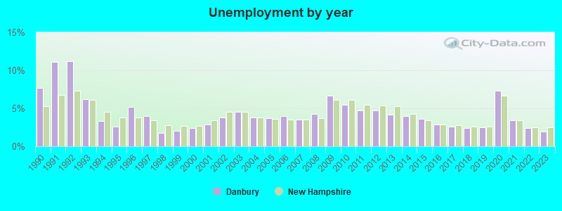
- Unemployed: 3.4%
- Mean travel time to work (commute): 35.7 minutes


| Here: | 10.7 |
| New Hampshire average: | 10.9 |
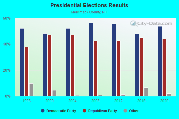
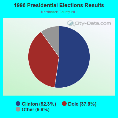
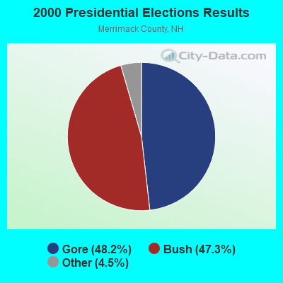
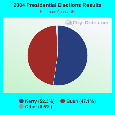

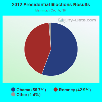
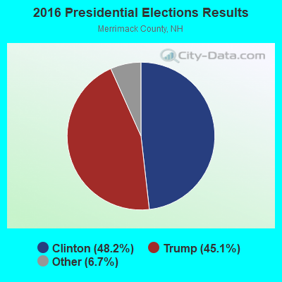
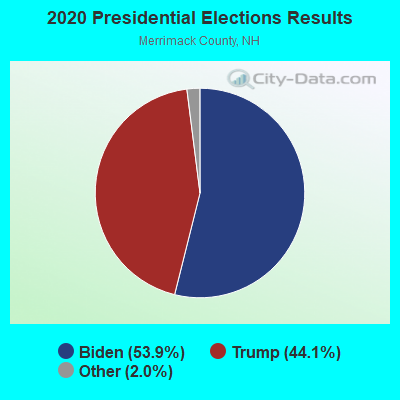
Graphs represent county-level data. Detailed 2008 Election Results
Religion statistics for Danbury, NH (based on Merrimack County data)
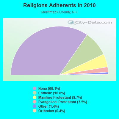
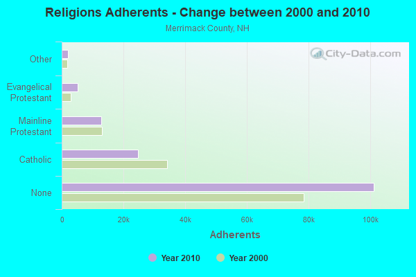
| Religion | Adherents | Congregations |
|---|---|---|
| Catholic | 24,654 | 7 |
| Mainline Protestant | 12,791 | 51 |
| Evangelical Protestant | 5,195 | 36 |
| Other | 2,097 | 15 |
| Orthodox | 580 | 2 |
| None | 101,128 | - |
Food Environment Statistics:
| Here: | 1.82 / 10,000 pop. |
| State: | 2.14 / 10,000 pop. |
| This county: | 0.14 / 10,000 pop. |
| State: | 0.15 / 10,000 pop. |
| Merrimack County: | 1.22 / 10,000 pop. |
| State: | 1.78 / 10,000 pop. |
| This county: | 4.39 / 10,000 pop. |
| New Hampshire: | 4.02 / 10,000 pop. |
| Merrimack County: | 7.77 / 10,000 pop. |
| New Hampshire: | 9.70 / 10,000 pop. |
| Merrimack County: | 7.4% |
| State: | 7.6% |
| This county: | 23.8% |
| State: | 24.4% |
| Merrimack County: | 16.9% |
| State: | 15.9% |
Businesses in Danbury, NH
- U-Haul: 1
Strongest AM radio stations in Danbury:
- WNTK (1020 AM; 10 kW; NEWPORT, NH; Owner: KOOR COMMUNICATIONS, INC.)
- WEZS (1350 AM; 5 kW; LACONIA, NH; Owner: GARY W. HAMMOND)
- WRKO (680 AM; 50 kW; BOSTON, MA; Owner: ENTERCOM BOSTON LICENSE, LLC)
- WPNH (1300 AM; 5 kW; PLYMOUTH, NH; Owner: NORTHEAST COMMUNICATIONS CORPORATION)
- WCRN (830 AM; 50 kW; WORCESTER, MA; Owner: CARTER BROADCASTING CORPORATION)
- WNNZ (640 AM; 50 kW; WESTFIELD, MA; Owner: CLEAR CHANNEL BROADCASTING LICENSES, INC.)
- WEEI (850 AM; 50 kW; BOSTON, MA; Owner: ENTERCOM BOSTON LICENSE, LLC)
- WFTN (1240 AM; 1 kW; FRANKLIN, NH; Owner: NORTHEAST COMMUNICATIONS CORPORATION)
- WKOX (1200 AM; 50 kW; FRAMINGHAM, MA; Owner: CAPSTAR TX LIMITED PARTNERSHIP)
- WBZ (1030 AM; 50 kW; BOSTON, MA; Owner: INFINITY BROADCASTING OPERATIONS, INC.)
- WBIX (1060 AM; 40 kW; NATICK, MA; Owner: LANGER BROADCASTING CORPORATION)
- WGIR (610 AM; 5 kW; MANCHESTER, NH; Owner: CAPSTAR TX LIMITED PARTNERSHIP)
- WWZN (1510 AM; 50 kW; BOSTON, MA; Owner: ROSE CITY RADIO CORPORATION)
Strongest FM radio stations in Danbury:
- WNTK-FM (99.7 FM; NEW LONDON, NH; Owner: SHEILA E. VINIKOOR)
- WHDQ (106.1 FM; CLAREMONT, NH; Owner: GREAT NORTHERN RADIO, L.L.C.)
- WPNH-FM (100.1 FM; PLYMOUTH, NH; Owner: NORTHEAST COMMUNICATIONS CORPORATION)
- WEVH (91.3 FM; HANOVER, NH; Owner: NEW HAMPSHIRE PUBLIC RADIO INC)
- WVPR (89.5 FM; WINDSOR, VT; Owner: VERMONT PUBLIC RADIO)
- WNHI (93.3 FM; BELMONT, NH; Owner: CONCORD BROADCASTING, L.L.C.)
- WSCY (106.9 FM; MOULTONBOROUGH, NH; Owner: NORTHEAST COMMUNICATIONS CORPORATION)
- WVFM (105.7 FM; CAMPTON, NH; Owner: DEVON BROADCASTING COMPANY, INC.)
- WVRR (101.7 FM; NEWPORT, NH; Owner: CAPSTAR TX LIMITED PARTNERSHIP)
- WPKQ (103.7 FM; NORTH CONWAY, NH; Owner: CITADEL BROADCASTING COMPANY)
- WHOM (94.9 FM; MT. WASHINGTON, NH; Owner: CITADEL BROADCASTING COMPANY)
- WSCS (90.9 FM; NEW LONDON, NH; Owner: COLBY-SAWYER COLLEGE)
- WJJR (98.1 FM; RUTLAND, VT; Owner: 6 JOHNSON ROAD LICENSES, INC.)
- WZRT (97.1 FM; RUTLAND, VT; Owner: CAPSTAR TX LIMITED PARTNERSHIP)
- WLKZ (104.9 FM; WOLFEBORO, NH; Owner: TELE-MEDIA COMPANY OF NEW HAMPSHIRE, L.L.C.)
- WFTN-FM (94.1 FM; FRANKLIN, NH; Owner: NORTHEAST COMMUNICATIONS CORPORATION)
- WEBK (105.3 FM; KILLINGTON, VT; Owner: 6 JOHNSON ROAD LICENSES, INC.)
- WGLV (91.7 FM; WOODSTOCK, VT; Owner: CHRISTIAN MINISTRIES INC)
- WHDQ-FM1 (106.1 FM; RUTLAND, VT; Owner: GREAT NORTHERN RADIO, L.L.C.)
- WNNH (99.1 FM; HENNIKER, NH; Owner: TELE-MEDIA COMPANY OF NEW HAMPSHIRE, L.L.C.)
TV broadcast stations around Danbury:
- WMEA-TV (Channel 26; BIDDEFORD, ME; Owner: MAINE PUBLIC BROADCASTING CORP.)
- W15BK (Channel 15; HANOVER, NH; Owner: UNIVERSITY OF NEW HAMPSHIRE)
- Danbury, New Hampshire
- Fatal accident count23
- Vehicles involved in fatal accidents30
- Fatal accidents involving drunk persons:13
- Fatalities24
- Persons involved in fatal accidents54
- Pedestrians involved in fatal accidents0
- New Hampshire average
- Fatal accident count2202
- Vehicles involved in fatal accidents3143
- Fatal accidents involving drunk persons1015
- Fatalities2436
- Persons involved in fatal accidents5252
- Pedestrians involved in fatal accidents67
- National Bridge Inventory (NBI) Statistics
- 17Number of bridges
- 92ft / 27.6mTotal length
- $53,414,000Total costs
- 13,977Total average daily traffic
- 729Total average daily truck traffic
- 20,675Total future (year 2042) average daily traffic

- New bridges - historical statistics
- 21920-1929
- 31930-1939
- 31940-1949
- 71950-1959
- 21980-1989
FCC Registered Broadcast Land Mobile Towers:
1- Lat: 43.537139 Lon: -71.844361, Call Sign: WPTN928,
Assigned Frequencies: 467.812 MHz, Grant Date: 11/13/2001, Expiration Date: 11/13/2011, Cancellation Date: 01/14/2012, Certifier: Carl W Gehring, Registrant: Northeastern Land Services Ltd, One Office Parkway, East Providence, RI 02914, Phone: (401) 435-4050, Fax: (401) 435-4055
FCC Registered Microwave Towers:
1- RAGGED MT, Ragged Mt Ski Area (Lat: 43.472389 Lon: -71.844611), Type: Tower, Structure height: 30.9 m, Overall height: 34.7 m, Call Sign: WPQY766,
Assigned Frequencies: 5974.85 MHz, 5945.20 MHz, 6093.45 MHz, Grant Date: 11/02/2010, Expiration Date: 12/05/2020, Cancellation Date: 08/13/2015, Certifier: Richard Craig, Registrant: Verizon Wireless, 1120 Sanctuary Pkwy, #150 Gasa5reg, Alpharetta, GA 30009-7630, Phone: (770) 797-1070, Fax: (770) 797-1036, Email:
FCC Registered Amateur Radio Licenses:
13 (See the full list of FCC Registered Amateur Radio Licenses in Danbury)2007 - 2018 National Fire Incident Reporting System (NFIRS) incidents
- Fire incident types reported to NFIRS in Danbury, NH
- 9675.0%Structure Fires
- 2519.5%Outside Fires
- 53.9%Mobile Property/Vehicle Fires
- 21.6%Other
 According to the data from the years 2007 - 2018 the average number of fires per year is 11. The highest number of reported fire incidents - 23 took place in 2016, and the least - 1 in 2010. The data has a growing trend.
 When looking into fire subcategories, the most reports belonged to: Structure Fires (75.0%), and Outside Fires (19.5%).
- 56.0%Fuel oil, kerosene, etc.
- 24.5%Bottled, tank, or LP gas
- 17.3%Wood
- 1.3%Electricity
- 0.8%Utility gas

- 68.3%Fuel oil, kerosene, etc.
- 16.7%Wood
- 15.0%Bottled, tank, or LP gas
Danbury compared to New Hampshire state average:
- Unemployed percentage significantly below state average.
- Black race population percentage significantly below state average.
- Hispanic race population percentage below state average.
- Foreign-born population percentage significantly below state average.
- Renting percentage below state average.
- Length of stay since moving in significantly above state average.
- Number of rooms per house significantly below state average.
- House age significantly below state average.
- Percentage of population with a bachelor's degree or higher below state average.

|
Total of 12 patent applications in 2008-2024.