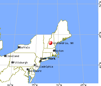
Alexandria, New Hampshire
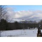
Alexandria: Mount Cardigan
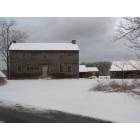
Alexandria: Ira Thissel home
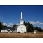
Alexandria: Alexandria Methodist Church

Alexandria: Brock Brook
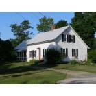
Alexandria: Tucker House - home of the Alexandria Historical Society
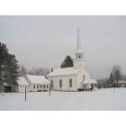
Alexandria: Alexandria Village Church

Alexandria: Newfound Lake near the ledges

Alexandria: comfort station
- add
your
Submit your own pictures of this town and show them to the world
- OSM Map
- General Map
- Google Map
- MSN Map
Population change since 2000: +21.4%
| Males: 822 | |
| Females: 791 |
| Median resident age: | 44.6 years |
| New Hampshire median age: | 43.9 years |
Zip codes: 03222.
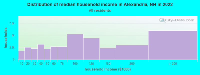
| Alexandria: | $83,423 |
| NH: | $89,992 |
Estimated per capita income in 2022: $43,940 (it was $19,323 in 2000)
Alexandria town income, earnings, and wages data
Estimated median house or condo value in 2022: $288,300 (it was $90,200 in 2000)
| Alexandria: | $288,300 |
| NH: | $384,700 |
Mean prices in 2022: all housing units: $486,096; detached houses: $533,852; townhouses or other attached units: $375,744; in 2-unit structures: $230,260; in 3-to-4-unit structures: $242,363; in 5-or-more-unit structures: $588,257; mobile homes: $127,035
Detailed information about poverty and poor residents in Alexandria, NH


- 1,53495.1%White alone
- 261.6%American Indian alone
- 251.5%Two or more races
- 130.8%Hispanic
- 90.6%Asian alone
- 60.4%Black alone
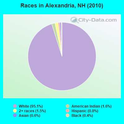
Races in Alexandria detailed stats: ancestries, foreign born residents, place of birth
According to our research of New Hampshire and other state lists, there were 10 registered sex offenders living in Alexandria, New Hampshire as of May 17, 2024.
The ratio of all residents to sex offenders in Alexandria is 161 to 1.
Type |
2009 |
2010 |
2011 |
2012 |
2013 |
2014 |
2015 |
2016 |
2017 |
2018 |
2019 |
2020 |
2021 |
2022 |
|---|---|---|---|---|---|---|---|---|---|---|---|---|---|---|
| Murders (per 100,000) | 0 (0.0) | 0 (0.0) | 0 (0.0) | 0 (0.0) | 0 (0.0) | 0 (0.0) | 0 (0.0) | 0 (0.0) | 0 (0.0) | 0 (0.0) | 0 (0.0) | 0 (0.0) | 0 (0.0) | 0 (0.0) |
| Rapes (per 100,000) | 1 (64.1) | 1 (62.0) | 0 (0.0) | 0 (0.0) | 0 (0.0) | 0 (0.0) | 0 (0.0) | 0 (0.0) | 0 (0.0) | 1 (62.1) | 0 (0.0) | 1 (61.8) | 2 (122.8) | 0 (0.0) |
| Robberies (per 100,000) | 0 (0.0) | 1 (62.0) | 0 (0.0) | 0 (0.0) | 0 (0.0) | 0 (0.0) | 0 (0.0) | 0 (0.0) | 0 (0.0) | 0 (0.0) | 0 (0.0) | 0 (0.0) | 0 (0.0) | 0 (0.0) |
| Assaults (per 100,000) | 1 (64.1) | 1 (62.0) | 1 (61.9) | 2 (124.1) | 0 (0.0) | 0 (0.0) | 2 (122.5) | 3 (184.6) | 0 (0.0) | 2 (124.1) | 0 (0.0) | 1 (61.8) | 0 (0.0) | 1 (55.9) |
| Burglaries (per 100,000) | 15 (960.9) | 12 (744.0) | 13 (805.0) | 21 (1,303) | 2 (124.7) | 17 (1,054) | 1 (61.2) | 5 (307.7) | 6 (370.4) | 0 (0.0) | 3 (185.2) | 1 (61.8) | 2 (122.8) | 0 (0.0) |
| Thefts (per 100,000) | 15 (960.9) | 25 (1,550) | 20 (1,238) | 29 (1,799) | 9 (561.1) | 11 (682.0) | 0 (0.0) | 12 (738.5) | 7 (432.1) | 15 (931.1) | 12 (740.7) | 9 (556.2) | 3 (184.2) | 4 (223.6) |
| Auto thefts (per 100,000) | 0 (0.0) | 0 (0.0) | 0 (0.0) | 2 (124.1) | 0 (0.0) | 0 (0.0) | 0 (0.0) | 2 (123.1) | 0 (0.0) | 0 (0.0) | 1 (61.7) | 1 (61.8) | 0 (0.0) | 0 (0.0) |
| Arson (per 100,000) | 0 (0.0) | 0 (0.0) | 0 (0.0) | 0 (0.0) | 0 (0.0) | 0 (0.0) | 0 (0.0) | 1 (61.5) | 0 (0.0) | 0 (0.0) | 0 (0.0) | 0 (0.0) | 0 (0.0) | 0 (0.0) |
| City-Data.com crime index | 169.8 | 194.7 | 118.3 | 197.9 | 31.2 | 101.1 | 28.8 | 97.8 | 43.2 | 111.7 | 47.5 | 93.3 | 114.2 | 20.1 |
The City-Data.com crime index weighs serious crimes and violent crimes more heavily. Higher means more crime, U.S. average is 246.1. It adjusts for the number of visitors and daily workers commuting into cities.
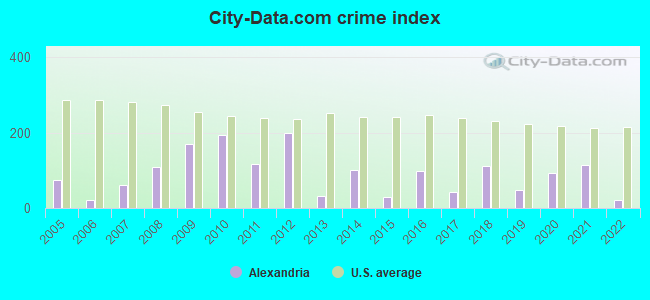
Crime rate in Alexandria detailed stats: murders, rapes, robberies, assaults, burglaries, thefts, arson
Full-time law enforcement employees in 2021, including police officers: 2 (2 officers - 2 male; 0 female).
| Officers per 1,000 residents here: | 1.23 |
| New Hampshire average: | 2.14 |
 Recent articles from our blog. Our writers, many of them Ph.D. graduates or candidates, create easy-to-read articles on a wide variety of topics.

 | NH Sale & Income tax offset with property taxes? (150 replies) |
| Moving from Va to NH looking for some advice :) (32 replies) |
| Picture Thread for NH (1997 replies) |
| Best town in NH for a chest-thumping Libertarian? (30 replies) |
| Maryland to New Hampshire? (16 replies) |
| Campton - Plymouth Area (26 replies) |
Latest news from Alexandria, NH collected exclusively by city-data.com from local newspapers, TV, and radio stations
Ancestries: English (25.8%), French (21.4%), Irish (17.9%), United States (10.2%), German (8.6%), Italian (6.0%).
Current Local Time: EST time zone
Incorporated in 1782
Elevation: 625 feet
Land area: 43.0 square miles.
Population density: 38 people per square mile (very low).
33 residents are foreign born (1.0% Europe, 0.8% North America, 0.5% Latin America).
| This town: | 2.5% |
| New Hampshire: | 4.4% |
| Alexandria town: | 1.8% ($1,658) |
| New Hampshire: | 2.3% ($2,946) |
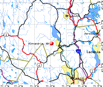
Nearest city with pop. 50,000+: Manchester, NH  (46.7 miles , pop. 107,006).
Nearest city with pop. 200,000+: Boston, MA (96.2 miles , pop. 589,141).
Nearest city with pop. 1,000,000+: Bronx, NY (218.4 miles , pop. 1,332,650).
Nearest cities:
), Latitude: 43.61 N, Longitude: 71.81 W
Area code commonly used in this area: 603

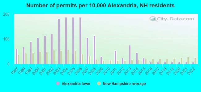
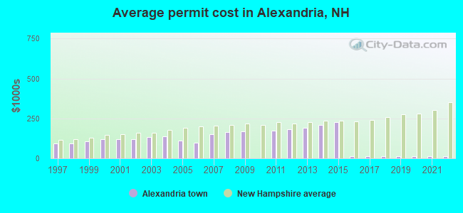
Single-family new house construction building permits:
- 2022: 1 building, cost: $15,000
- 2021: 1 building, cost: $15,000
- 2020: 1 building, cost: $15,000
- 2019: 1 building, cost: $15,000
- 2018: 1 building, cost: $15,000
- 2017: 1 building, cost: $15,000
- 2016: 1 building, cost: $15,000
- 2015: 3 buildings, average cost: $226,800
- 2014: 6 buildings, average cost: $211,200
- 2013: 10 buildings, average cost: $193,300
- 2012: 3 buildings, average cost: $184,000
- 2011: 7 buildings, average cost: $172,800
- 2009: 4 buildings, average cost: $168,800
- 2008: 15 buildings, average cost: $163,300
- 2007: 14 buildings, average cost: $150,000
- 2006: 25 buildings, average cost: $100,000
- 2005: 25 buildings, average cost: $110,000
- 2004: 25 buildings, average cost: $138,800
- 2003: 24 buildings, average cost: $132,800
- 2002: 16 buildings, average cost: $118,000
- 2001: 15 buildings, average cost: $118,000
- 2000: 14 buildings, average cost: $118,000
- 1999: 12 buildings, average cost: $109,200
- 1998: 9 buildings, average cost: $91,700
- 1997: 8 buildings, average cost: $91,700
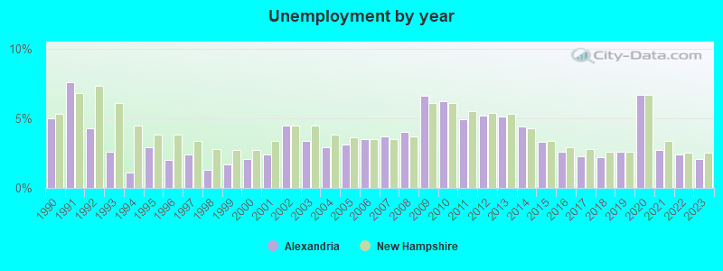
| Here: | 2.1% |
| New Hampshire: | 2.5% |
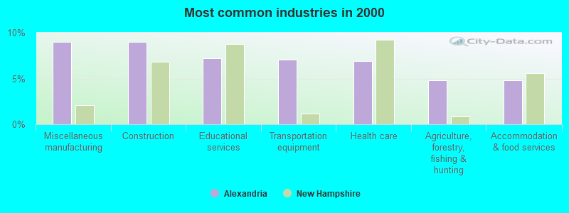
- Miscellaneous manufacturing (9.0%)
- Construction (9.0%)
- Educational services (7.2%)
- Transportation equipment (7.0%)
- Health care (6.9%)
- Agriculture, forestry, fishing & hunting (4.8%)
- Accommodation & food services (4.8%)
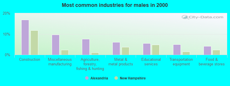
- Construction (16.8%)
- Miscellaneous manufacturing (9.7%)
- Agriculture, forestry, fishing & hunting (7.6%)
- Metal & metal products (6.0%)
- Educational services (5.5%)
- Transportation equipment (5.0%)
- Food & beverage stores (4.2%)
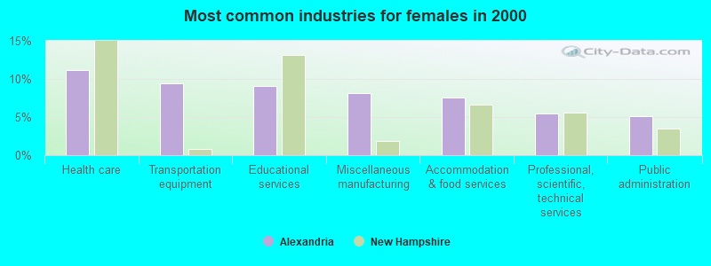
- Health care (11.2%)
- Transportation equipment (9.4%)
- Educational services (9.1%)
- Miscellaneous manufacturing (8.2%)
- Accommodation & food services (7.6%)
- Professional, scientific, technical services (5.5%)
- Public administration (5.2%)
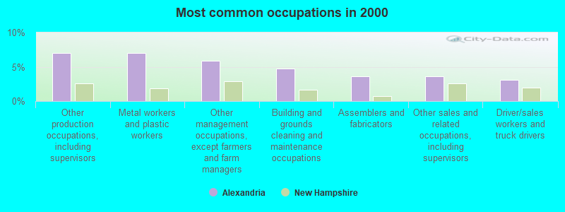
- Other production occupations, including supervisors (7.0%)
- Metal workers and plastic workers (7.0%)
- Other management occupations, except farmers and farm managers (5.9%)
- Building and grounds cleaning and maintenance occupations (4.8%)
- Assemblers and fabricators (3.7%)
- Other sales and related occupations, including supervisors (3.7%)
- Driver/sales workers and truck drivers (3.1%)
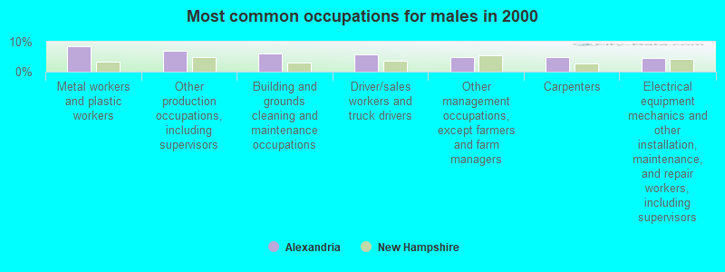
- Metal workers and plastic workers (8.4%)
- Other production occupations, including supervisors (6.8%)
- Building and grounds cleaning and maintenance occupations (6.0%)
- Driver/sales workers and truck drivers (5.8%)
- Other management occupations, except farmers and farm managers (5.0%)
- Carpenters (4.7%)
- Electrical equipment mechanics and other installation, maintenance, and repair workers, including supervisors (4.5%)
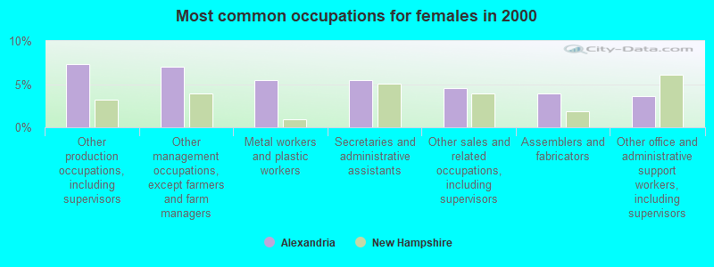
- Other production occupations, including supervisors (7.3%)
- Other management occupations, except farmers and farm managers (7.0%)
- Metal workers and plastic workers (5.5%)
- Secretaries and administrative assistants (5.5%)
- Other sales and related occupations, including supervisors (4.5%)
- Assemblers and fabricators (3.9%)
- Other office and administrative support workers, including supervisors (3.6%)
Average climate in Alexandria, New Hampshire
Based on data reported by over 4,000 weather stations


(lower is better)

Air Quality Index (AQI) level in 2022 was 46.9. This is significantly better than average.
| City: | 46.9 |
| U.S.: | 72.6 |
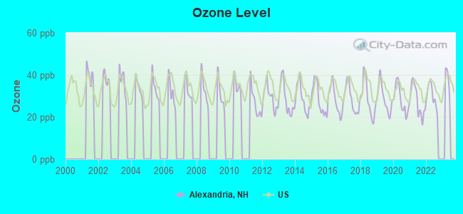
Ozone [ppb] level in 2022 was 29.9. This is about average. Closest monitor was 12.0 miles away from the city center.
| City: | 29.9 |
| U.S.: | 33.3 |
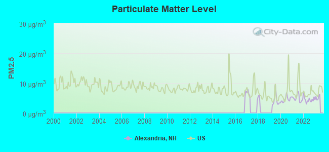
Particulate Matter (PM2.5) [µg/m3] level in 2022 was 4.52. This is significantly better than average. Closest monitor was 11.8 miles away from the city center.
| City: | 4.52 |
| U.S.: | 8.11 |
Tornado activity:
Alexandria-area historical tornado activity is slightly below New Hampshire state average. It is 62% smaller than the overall U.S. average.
On 5/11/1973, a category F2 (max. wind speeds 113-157 mph) tornado 7.7 miles away from the Alexandria town center .
On 7/3/1972, a category F2 tornado 23.0 miles away from the town center injured 7 people and caused between $5000 and $50,000 in damages.
Earthquake activity:
Alexandria-area historical earthquake activity is significantly above New Hampshire state average. It is 71% smaller than the overall U.S. average.On 4/20/2002 at 10:50:47, a magnitude 5.3 (5.3 ML, Depth: 3.0 mi, Class: Moderate, Intensity: VI - VII) earthquake occurred 112.8 miles away from the city center
On 10/7/1983 at 10:18:46, a magnitude 5.3 (5.1 MB, 5.3 LG, 5.1 ML) earthquake occurred 128.8 miles away from Alexandria center
On 4/20/2002 at 10:50:47, a magnitude 5.2 (5.2 MB, 4.2 MS, 5.2 MW, 5.0 MW) earthquake occurred 112.7 miles away from the city center
On 1/19/1982 at 00:14:42, a magnitude 4.7 (4.5 MB, 4.7 MD, 4.5 LG, Class: Light, Intensity: IV - V) earthquake occurred 12.8 miles away from the city center
On 10/16/2012 at 23:12:25, a magnitude 4.7 (4.7 ML, Depth: 10.0 mi) earthquake occurred 57.7 miles away from Alexandria center
On 8/21/1996 at 07:54:14, a magnitude 3.8 (3.8 LG, 3.6 LG, Depth: 6.2 mi, Class: Light, Intensity: II - III) earthquake occurred 45.8 miles away from the city center
Magnitude types: regional Lg-wave magnitude (LG), body-wave magnitude (MB), duration magnitude (MD), local magnitude (ML), surface-wave magnitude (MS), moment magnitude (MW)
Natural disasters:
The number of natural disasters in Grafton County (32) is a lot greater than the US average (15).Major Disasters (Presidential) Declared: 20
Emergencies Declared: 9
Causes of natural disasters: Floods: 16, Storms: 16, Hurricanes: 3, Snows: 3, Winter Storms: 3, Tropical Storms: 2, Blizzard: 1, Heavy Rain: 1, Ice Storm: 1, Landslide: 1, Snowfall: 1, Snowstorm: 1, Wind: 1, Other: 1 (Note: some incidents may be assigned to more than one category).

Hospitals and medical centers near Alexandria:
- NEWFOUND AREA NURSING ASSN (Home Health Center, about 4 miles away; BRISTOL, NH)
- SPEARE MEMORIAL HOSPITAL Critical Access Hospitals (about 12 miles away; PLYMOUTH, NH)
- MERRILL MANOR NURSING HOME (Nursing Home, about 14 miles away; FRANKLIN, NH)
- FRANKLIN REGIONAL HOSPITAL Critical Access Hospitals (about 14 miles away; FRANKLIN, NH)
- VNA OF FRANKLIN (Home Health Center, about 14 miles away; FRANKLIN, NH)
- MERRILL MANOR ANNEX (Nursing Home, about 14 miles away; FRANKLIN, NH)
- MOUNTAIN RIDGE CENTER, GENESIS HEALTHCARE (Nursing Home, about 15 miles away; FRANKLIN, NH)
Colleges/universities with over 2000 students nearest to Alexandria:
- Plymouth State University (about 12 miles; Plymouth, NH; Full-time enrollment: 4,838)
- Dartmouth College (about 26 miles; Hanover, NH; FT enrollment: 6,030)
- NHTI-Concord's Community College (about 31 miles; Concord, NH; FT enrollment: 2,865)
- Southern New Hampshire University (about 44 miles; Manchester, NH; FT enrollment: 16,552)
- Saint Anselm College (about 46 miles; Manchester, NH; FT enrollment: 2,059)
- Mount Washington College (about 48 miles; Manchester, NH; FT enrollment: 2,187)
- Keene State College (about 53 miles; Keene, NH; FT enrollment: 5,098)
Points of interest:
Notable locations in Alexandria: Cardigan Mountain Orchard (A), Alexandria Volunteer Fire Department (B). Display/hide their locations on the map
Cemeteries: Crawford Cemetery (1), Burns Hill Cemetery (2), Riverside Cemetery (3). Display/hide their locations on the map
Lakes: Foster Pond (A), Goose Pond (B). Display/hide their locations on the map
Streams, rivers, and creeks: Town Brook (A), Templeton Brook (B), Patten Brook (C), Fowler River (D), Clark Brook (E), Chesley Brook (F), Brock Brook (G), Bailey Brook (H). Display/hide their locations on the map
Birthplace of: William E. Blaisdell - General.
Drinking water stations with addresses in Alexandria and their reported violations in the past:
US FS - HASTINGS CAMPGROUND (Serves ME, Population served: 60, Groundwater):Past monitoring violations:VILLAGE PIZZA OF BRISTOL (Population served: 50, Groundwater):
- 5 routine major monitoring violations
- One regular monitoring violation
Past monitoring violations:
- 2 routine major monitoring violations
| This town: | 2.5 people |
| New Hampshire: | 2.5 people |
| This town: | 74.4% |
| Whole state: | 66.3% |
| This town: | 11.0% |
| Whole state: | 8.3% |
Likely homosexual households (counted as self-reported same-sex unmarried-partner households)
- Lesbian couples: 0.8% of all households
- Gay men: 1.1% of all households
| This town: | 6.3% |
| Whole state: | 6.5% |
| This town: | 2.8% |
| Whole state: | 2.8% |
For population 15 years and over in Alexandria:
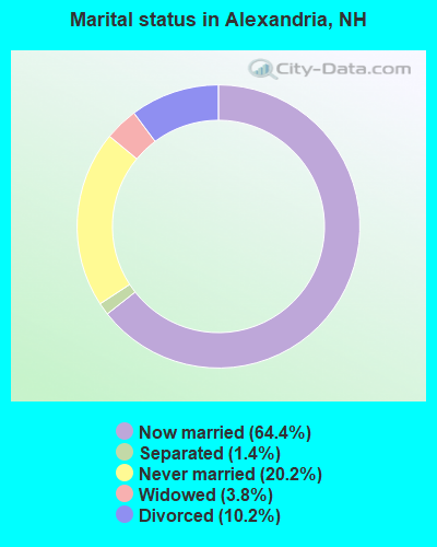
- Never married: 20.2%
- Now married: 64.4%
- Separated: 1.4%
- Widowed: 3.8%
- Divorced: 10.2%
For population 25 years and over in Alexandria:
- High school or higher: 84.1%
- Bachelor's degree or higher: 18.4%
- Graduate or professional degree: 5.8%
- Unemployed: 3.7%
- Mean travel time to work (commute): 26.3 minutes

| Here: | 9.2 |
| New Hampshire average: | 10.9 |


Graphs represent county-level data. Detailed 2008 Election Results
Religion statistics for Alexandria, NH (based on Grafton County data)


| Religion | Adherents | Congregations |
|---|---|---|
| Catholic | 9,503 | 12 |
| Mainline Protestant | 7,832 | 57 |
| Evangelical Protestant | 1,494 | 29 |
| Other | 1,320 | 11 |
| None | 68,969 | - |
Food Environment Statistics:
| Grafton County: | 3.87 / 10,000 pop. |
| New Hampshire: | 2.14 / 10,000 pop. |
| This county: | 0.23 / 10,000 pop. |
| State: | 0.15 / 10,000 pop. |
| Grafton County: | 1.29 / 10,000 pop. |
| New Hampshire: | 1.78 / 10,000 pop. |
| Grafton County: | 6.45 / 10,000 pop. |
| State: | 4.02 / 10,000 pop. |
| Here: | 14.41 / 10,000 pop. |
| State: | 9.70 / 10,000 pop. |
| This county: | 7.2% |
| New Hampshire: | 7.6% |
| Grafton County: | 22.9% |
| New Hampshire: | 24.4% |
| This county: | 15.9% |
| State: | 15.9% |
Strongest AM radio stations in Alexandria:
- WPNH (1300 AM; 5 kW; PLYMOUTH, NH; Owner: NORTHEAST COMMUNICATIONS CORPORATION)
- WNTK (1020 AM; 10 kW; NEWPORT, NH; Owner: KOOR COMMUNICATIONS, INC.)
- WEZS (1350 AM; 5 kW; LACONIA, NH; Owner: GARY W. HAMMOND)
- WRKO (680 AM; 50 kW; BOSTON, MA; Owner: ENTERCOM BOSTON LICENSE, LLC)
- WCRN (830 AM; 50 kW; WORCESTER, MA; Owner: CARTER BROADCASTING CORPORATION)
- WEEI (850 AM; 50 kW; BOSTON, MA; Owner: ENTERCOM BOSTON LICENSE, LLC)
- WNNZ (640 AM; 50 kW; WESTFIELD, MA; Owner: CLEAR CHANNEL BROADCASTING LICENSES, INC.)
- WKOX (1200 AM; 50 kW; FRAMINGHAM, MA; Owner: CAPSTAR TX LIMITED PARTNERSHIP)
- WBZ (1030 AM; 50 kW; BOSTON, MA; Owner: INFINITY BROADCASTING OPERATIONS, INC.)
- WGIN (930 AM; 10 kW; ROCHESTER, NH; Owner: CAPSTAR TX LIMITED PARTNERSHIP)
- WFTN (1240 AM; 1 kW; FRANKLIN, NH; Owner: NORTHEAST COMMUNICATIONS CORPORATION)
- WBIX (1060 AM; 40 kW; NATICK, MA; Owner: LANGER BROADCASTING CORPORATION)
- WWZN (1510 AM; 50 kW; BOSTON, MA; Owner: ROSE CITY RADIO CORPORATION)
Strongest FM radio stations in Alexandria:
- WPNH-FM (100.1 FM; PLYMOUTH, NH; Owner: NORTHEAST COMMUNICATIONS CORPORATION)
- WSCY (106.9 FM; MOULTONBOROUGH, NH; Owner: NORTHEAST COMMUNICATIONS CORPORATION)
- WHDQ (106.1 FM; CLAREMONT, NH; Owner: GREAT NORTHERN RADIO, L.L.C.)
- WEVH (91.3 FM; HANOVER, NH; Owner: NEW HAMPSHIRE PUBLIC RADIO INC)
- WVFM (105.7 FM; CAMPTON, NH; Owner: DEVON BROADCASTING COMPANY, INC.)
- WPKQ (103.7 FM; NORTH CONWAY, NH; Owner: CITADEL BROADCASTING COMPANY)
- WNHI (93.3 FM; BELMONT, NH; Owner: CONCORD BROADCASTING, L.L.C.)
- WHOM (94.9 FM; MT. WASHINGTON, NH; Owner: CITADEL BROADCASTING COMPANY)
- WVPR (89.5 FM; WINDSOR, VT; Owner: VERMONT PUBLIC RADIO)
- WNTK-FM (99.7 FM; NEW LONDON, NH; Owner: SHEILA E. VINIKOOR)
- WLKZ (104.9 FM; WOLFEBORO, NH; Owner: TELE-MEDIA COMPANY OF NEW HAMPSHIRE, L.L.C.)
- WFTN-FM (94.1 FM; FRANKLIN, NH; Owner: NORTHEAST COMMUNICATIONS CORPORATION)
- WJJR (98.1 FM; RUTLAND, VT; Owner: 6 JOHNSON ROAD LICENSES, INC.)
- WZRT (97.1 FM; RUTLAND, VT; Owner: CAPSTAR TX LIMITED PARTNERSHIP)
- WEBK (105.3 FM; KILLINGTON, VT; Owner: 6 JOHNSON ROAD LICENSES, INC.)
- WVRR (101.7 FM; NEWPORT, NH; Owner: CAPSTAR TX LIMITED PARTNERSHIP)
- WGLV (91.7 FM; WOODSTOCK, VT; Owner: CHRISTIAN MINISTRIES INC)
- WHDQ-FM1 (106.1 FM; RUTLAND, VT; Owner: GREAT NORTHERN RADIO, L.L.C.)
- WLNH-FM (98.3 FM; LACONIA, NH; Owner: WLNH RADIO, INC)
- WXXK (100.5 FM; LEBANON, NH; Owner: CAPSTAR TX LIMITED PARTNERSHIP)
TV broadcast stations around Alexandria:
- WMEA-TV (Channel 26; BIDDEFORD, ME; Owner: MAINE PUBLIC BROADCASTING CORP.)
- W15BK (Channel 15; HANOVER, NH; Owner: UNIVERSITY OF NEW HAMPSHIRE)
- WMTW-TV (Channel 8; POLAND SPRING, ME; Owner: WMTW BROADCAST GROUP, LLC)
Alexandria fatal accident list:
Jul 26, 1998 87:99 PM, Town Pound Road, Vehicles: 1, Persons: 1, Fatalities: 1, Drunk persons involved: 1
Dec 5, 1998 05:00 AM, Sr-104, Vehicles: 2, Persons: 2, Fatalities: 1, Drunk persons involved: 1
Apr 29, 1989 02:48 PM, 20133, Vehicles: 1, Persons: 1, Fatalities: 1, Drunk persons involved: 1
- National Bridge Inventory (NBI) Statistics
- 17Number of bridges
- 79ft / 24.3mTotal length
- $53,414,000Total costs
- 4,271Total average daily traffic
- 242Total average daily truck traffic
- 6,311Total future (year 2042) average daily traffic
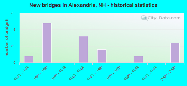
- New bridges - historical statistics
- 11920-1929
- 61930-1939
- 41950-1959
- 21960-1969
- 11980-1989
- 32000-2009
FCC Registered Amateur Radio Licenses: 9 (See the full list of FCC Registered Amateur Radio Licenses in Alexandria)
2004 - 2018 National Fire Incident Reporting System (NFIRS) incidents
- Fire incident types reported to NFIRS in Alexandria, NH
- 7064.2%Structure Fires
- 3229.4%Outside Fires
- 43.7%Other
- 32.8%Mobile Property/Vehicle Fires
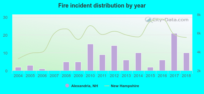 According to the data from the years 2004 - 2018 the average number of fires per year is 7. The highest number of reported fire incidents - 21 took place in 2017, and the least - 0 in 2007. The data has a growing trend.
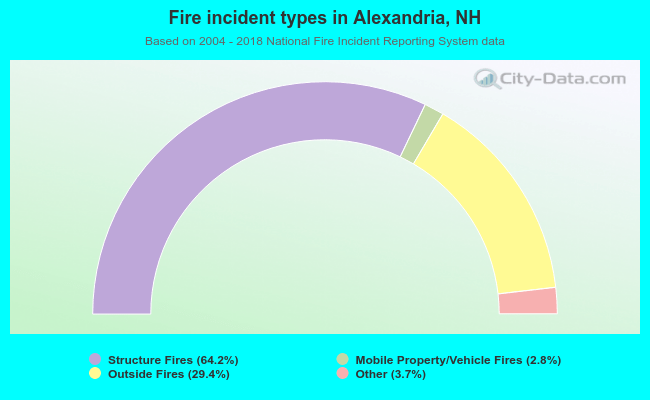 When looking into fire subcategories, the most reports belonged to: Structure Fires (64.2%), and Outside Fires (29.4%).
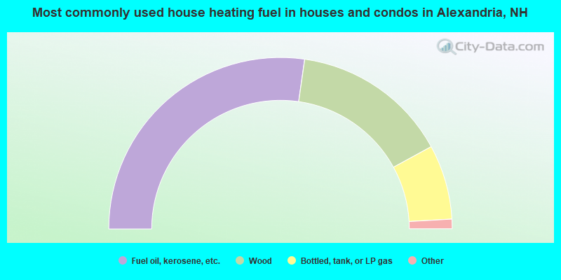
- 54.5%Fuel oil, kerosene, etc.
- 29.6%Wood
- 14.1%Bottled, tank, or LP gas
- 1.2%Electricity
- 0.7%Coal or coke
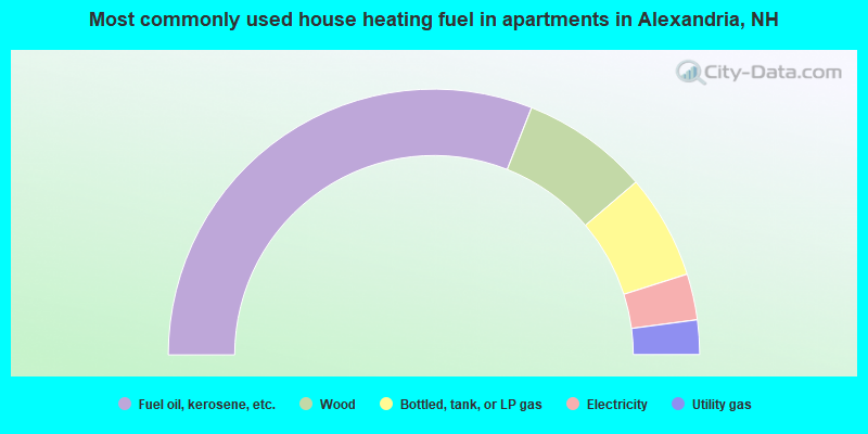
- 62.0%Fuel oil, kerosene, etc.
- 15.5%Wood
- 12.7%Bottled, tank, or LP gas
- 5.6%Electricity
- 4.2%Utility gas
Alexandria compared to New Hampshire state average:
- Unemployed percentage significantly below state average.
- Black race population percentage below state average.
- Hispanic race population percentage significantly below state average.
- Foreign-born population percentage significantly below state average.
- Renting percentage below state average.
- Length of stay since moving in significantly above state average.
- Number of rooms per house significantly below state average.
- House age significantly below state average.
- Percentage of population with a bachelor's degree or higher below state average.

|
Total of 24 patent applications in 2008-2024.