Decatur, Arkansas
Submit your own pictures of this city and show them to the world
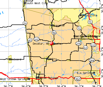
- OSM Map
- General Map
- Google Map
- MSN Map
Population change since 2000: +32.6%
| Males: 989 | |
| Females: 754 |
| Median resident age: | 35.0 years |
| Arkansas median age: | 38.9 years |
Zip codes: 72722.
| Decatur: | $40,189 |
| AR: | $55,432 |
Estimated per capita income in 2022: $20,348 (it was $11,618 in 2000)
Decatur city income, earnings, and wages data
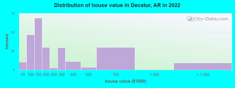
Estimated median house or condo value in 2022: $149,946 (it was $61,800 in 2000)
| Decatur: | $149,946 |
| AR: | $179,800 |
Mean prices in 2022: all housing units: $240,647; detached houses: $245,817; mobile homes: $84,136
Median gross rent in 2022: $761.
(18.7% for White Non-Hispanic residents, 28.6% for Black residents, 34.4% for Hispanic or Latino residents, 48.0% for other race residents, 21.1% for two or more races residents)
Detailed information about poverty and poor residents in Decatur, AR
Compare current foreclosures near Decatur, AR:
| Photo | Address | Area | Beds / Baths | Price | Details |
|---|---|---|---|---|---|

|
#1
Park St
Decatur, AR 72722
|
2,716 sq. feet
|
3 baths - beds |
show details | |

|
#2
Hidden Springs Dr Apt 61
Decatur, AR 72722
|
- sq. feet
|
- baths - beds |
show details | |

|
#3
W Highway 102
Decatur, AR 72722
|
1,344 sq. feet
|
- baths - beds |
show details | |

|
#4
N Main St
Decatur, AR 72722
|
- sq. feet
|
- baths - beds |
show details | |

|
#5
N Main St
Decatur, AR 72722
|
- sq. feet
|
- baths - beds |
show details | |

|
#6
Shortcut Rd
Decatur, AR 72722
|
1,280 sq. feet
|
- baths - beds |
show details | |

|
#7
Regent Ln
Bella Vista, AR 72715
|
1,579 sq. feet
|
2 baths 3 beds |
show details | |

|
#8
Holcombe Ln
Bella Vista, AR 72714
|
1,620 sq. feet
|
2 baths 3 beds |
show details | |

|
#9
Forest Drive
Centerton, AR 72719
|
1,526 sq. feet
|
2 baths 3 beds |
show details | |

|
#10
Timber Ridge St
Centerton, AR 72719
|
- sq. feet
|
2 baths 3 beds |
show details |
| Photo | Address | Area | Beds / Baths | Price | Details |
|---|---|---|---|---|---|

|
#11
Western Cedar Court
Siloam Springs, AR 72761
|
1,776 sq. feet
|
2 baths 3 beds |
show details | |

|
#12
Dassero Ct
Centerton, AR 72719
|
1,547 sq. feet
|
2 baths 3 beds |
show details | |

|
#13
Kirkby Cir
Bella Vista, AR 72715
|
1,612 sq. feet
|
2 baths 2 beds |
show details | |

|
#14
Cortney Cir
Siloam Springs, AR 72761
|
2,213 sq. feet
|
2 baths 4 beds |
show details | |

|
#15
Old Charley Rd
Gravette, AR 72736
|
3,129 sq. feet
|
3 baths 5 beds |
show details | |

|
#16
Bruce Rutherford Dr
Siloam Springs, AR 72761
|
2,098 sq. feet
|
2 baths 4 beds |
show details | |

|
#17
Excalibur Dr
Springdale, AR 72762
|
3,659 sq. feet
|
3 baths 5 beds |
show details | |

|
#18
Olmstead Cir
Bella Vista, AR 72715
|
1,436 sq. feet
|
2 baths 3 beds |
show details | |

|
#19
Crawford Ave
Gentry, AR 72734
|
- sq. feet
|
2 baths 3 beds |
show details | |

|
#20
Highway 244 N
Siloam Springs, AR 72761
|
3,052 sq. feet
|
3 baths 4 beds |
show details |
| Photo | Address | Area | Beds / Baths | Price | Details |
|---|---|---|---|---|---|

|
#21
Pine Ave
Gentry, AR 72734
|
768 sq. feet
|
1 baths - beds |
show details | |

|
#22
College Pl
Bentonville, AR 72712
|
2,010 sq. feet
|
2 baths - beds |
show details | |

|
#23
Ash Ct
Siloam Springs, AR 72761
|
1,406 sq. feet
|
2 baths - beds |
show details | |

|
#24
SW F St
Bentonville, AR 72712
|
1,136 sq. feet
|
1 baths - beds |
show details | |

|
#25
Wilton Ln
Bella Vista, AR 72715
|
1,592 sq. feet
|
2 baths - beds |
show details | |

|
#26
Kensington Dr
Bella Vista, AR 72715
|
1,462 sq. feet
|
2 baths - beds |
show details | |

|
#27
Mayfair Dr
Bella Vista, AR 72715
|
1,596 sq. feet
|
2 baths - beds |
show details | |

|
#28
Cromer Dr
Bella Vista, AR 72715
|
1,357 sq. feet
|
2 baths - beds |
show details | |

|
#29
Allison Dr
Bella Vista, AR 72715
|
2,162 sq. feet
|
2 baths - beds |
show details | |

|
#30
Lacy St
Siloam Springs, AR 72761
|
1,342 sq. feet
|
2 baths - beds |
show details |
| Photo | Address | Area | Beds / Baths | Price | Details |
|---|---|---|---|---|---|

|
#31
W Oak St
Rogers, AR 72758
|
2,001 sq. feet
|
2 baths - beds |
show details | |

|
#32
Niagara St
Springdale, AR 72762
|
2,457 sq. feet
|
2 baths - beds |
show details | |

|
#33
Shepton Ln
Bella Vista, AR 72715
|
1,512 sq. feet
|
2 baths - beds |
show details | |

|
#34
Henegar Dr
Siloam Springs, AR 72761
|
1,150 sq. feet
|
2 baths - beds |
show details | |

|
#35
Highway 16 E
Siloam Springs, AR 72761
|
1,354 sq. feet
|
1 baths - beds |
show details | |

|
#36
Kimberly Pl
Bentonville, AR 72712
|
2,736 sq. feet
|
2 baths - beds |
show details | |

|
#37
S Madison St
Siloam Springs, AR 72761
|
2,390 sq. feet
|
2 baths - beds |
show details | |

|
#38
N Mount Olive St
Siloam Springs, AR 72761
|
1,961 sq. feet
|
1 baths - beds |
show details | |

|
#39
W Mcleod Mdws
Rogers, AR 72758
|
2,380 sq. feet
|
2 baths - beds |
show details | |

|
#40
Old Highway 68
Siloam Springs, AR 72761
|
988 sq. feet
|
2 baths - beds |
show details |
| Photo | Address | Area | Beds / Baths | Price | Details |
|---|---|---|---|---|---|

|
#41
Wildwood Ln
Siloam Springs, AR 72761
|
1,431 sq. feet
|
2 baths - beds |
show details | |

|
#42
S College St
Siloam Springs, AR 72761
|
2,172 sq. feet
|
2 baths - beds |
show details | |

|
#43
S Lincoln St
Siloam Springs, AR 72761
|
1,260 sq. feet
|
1 baths - beds |
show details | |

|
#44
Sheffield Rd
Siloam Springs, AR 72761
|
3,276 sq. feet
|
3 baths - beds |
show details | |

|
#45
Wood Tree Ct
Siloam Springs, AR 72761
|
1,014 sq. feet
|
1 baths - beds |
show details | |

|
#46
S Maxwell St
Siloam Springs, AR 72761
|
2,026 sq. feet
|
2 baths - beds |
show details | |

|
#47
W Granite St
Siloam Springs, AR 72761
|
1,215 sq. feet
|
1 baths - beds |
show details | |

|
#48
Oakhurst St
Bentonville, AR 72712
|
1,943 sq. feet
|
2 baths - beds |
show details | |

|
#49
SW Krug Rd
Bentonville, AR 72712
|
1,616 sq. feet
|
2 baths - beds |
show details | |

|
Check over 1 million property listings on Foreclosure.com!
|
browse all offers | |||


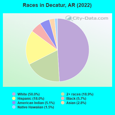
- 78850.0%White alone
- 29818.9%Two or more races
- 28318.0%Hispanic
- 905.7%Black alone
- 805.1%American Indian alone
- 442.8%Asian alone
- 231.5%Native Hawaiian and Other
Pacific Islander alone
According to our research of Arkansas and other state lists, there were 9 registered sex offenders living in Decatur, Arkansas as of May 15, 2024.
The ratio of all residents to sex offenders in Decatur is 266 to 1.
Type |
2009 |
2010 |
2011 |
2012 |
2013 |
2014 |
2015 |
2016 |
2017 |
2018 |
2019 |
2020 |
2021 |
2022 |
|---|---|---|---|---|---|---|---|---|---|---|---|---|---|---|
| Murders (per 100,000) | 0 (0.0) | 0 (0.0) | 0 (0.0) | 0 (0.0) | 0 (0.0) | 0 (0.0) | 0 (0.0) | 0 (0.0) | 0 (0.0) | 0 (0.0) | 0 (0.0) | 0 (0.0) | 0 (0.0) | 0 (0.0) |
| Rapes (per 100,000) | 0 (0.0) | 1 (58.9) | 0 (0.0) | 0 (0.0) | 1 (56.6) | 3 (169.4) | 3 (168.4) | 6 (335.8) | 9 (499.2) | 9 (496.1) | 8 (441.3) | 4 (222.1) | 3 (166.7) | 1 (57.7) |
| Robberies (per 100,000) | 0 (0.0) | 0 (0.0) | 0 (0.0) | 0 (0.0) | 0 (0.0) | 0 (0.0) | 0 (0.0) | 0 (0.0) | 0 (0.0) | 0 (0.0) | 0 (0.0) | 1 (55.5) | 0 (0.0) | 0 (0.0) |
| Assaults (per 100,000) | 5 (251.3) | 3 (176.6) | 1 (58.4) | 6 (342.5) | 8 (453.0) | 2 (112.9) | 4 (224.6) | 3 (167.9) | 4 (221.9) | 6 (330.8) | 9 (496.4) | 13 (721.8) | 12 (666.7) | 5 (288.5) |
| Burglaries (per 100,000) | 18 (904.5) | 23 (1,354) | 10 (584.1) | 19 (1,084) | 12 (679.5) | 11 (621.1) | 13 (729.9) | 19 (1,063) | 10 (554.6) | 11 (606.4) | 10 (551.6) | 6 (333.1) | 5 (277.8) | 4 (230.8) |
| Thefts (per 100,000) | 16 (804.0) | 11 (647.4) | 7 (408.9) | 12 (684.9) | 12 (679.5) | 48 (2,710) | 35 (1,965) | 29 (1,623) | 17 (942.9) | 34 (1,874) | 36 (1,986) | 34 (1,888) | 31 (1,722) | 21 (1,212) |
| Auto thefts (per 100,000) | 1 (50.3) | 0 (0.0) | 0 (0.0) | 3 (171.2) | 0 (0.0) | 1 (56.5) | 0 (0.0) | 3 (167.9) | 1 (55.5) | 5 (275.6) | 3 (165.5) | 5 (277.6) | 4 (222.2) | 1 (57.7) |
| Arson (per 100,000) | 0 (0.0) | 0 (0.0) | 0 (0.0) | 1 (57.1) | 0 (0.0) | 0 (0.0) | 0 (0.0) | 0 (0.0) | 0 (0.0) | 1 (55.1) | 0 (0.0) | 0 (0.0) | 0 (0.0) | 0 (0.0) |
| City-Data.com crime index | 149.7 | 203.1 | 68.9 | 185.5 | 210.6 | 314.5 | 309.4 | 455.0 | 524.7 | 602.5 | 583.6 | 459.7 | 372.8 | 173.1 |
The City-Data.com crime index weighs serious crimes and violent crimes more heavily. Higher means more crime, U.S. average is 246.1. It adjusts for the number of visitors and daily workers commuting into cities.

Crime rate in Decatur detailed stats: murders, rapes, robberies, assaults, burglaries, thefts, arson
Full-time law enforcement employees in 2021, including police officers: 7 (7 officers - 7 male; 0 female).
| Officers per 1,000 residents here: | 3.89 |
| Arkansas average: | 2.25 |
 Recent articles from our blog. Our writers, many of them Ph.D. graduates or candidates, create easy-to-read articles on a wide variety of topics.

 | Where can I find small historic homes in NWA? (10 replies) |
| How do the cities compare? (4 replies) |
| The Small Towns Sprinkled In The Area, Are They Cute? (11 replies) |
| Vegan restaurant in Decatur? (1 reply) |
| Looking to rent a home/trailer home in the Decatur area (0 replies) |
| Country Living Near Fayetteville/Bentonville/Rogers? (12 replies) |
Latest news from Decatur, AR collected exclusively by city-data.com from local newspapers, TV, and radio stations
Ancestries: American (4.8%), German (4.1%), Welsh (2.5%), English (2.0%), Irish (1.9%), European (1.4%).
Current Local Time: CST time zone
Elevation: 1239 feet
Land area: 2.29 square miles.
Population density: 760 people per square mile (low).
183 residents are foreign born (6.6% Latin America, 3.0% Africa, 1.5% Oceania).
| This city: | 11.6% |
| Arkansas: | 5.0% |
Median real estate property taxes paid for housing units with mortgages in 2022: $591 (0.4%)
Median real estate property taxes paid for housing units with no mortgage in 2022: $869 (0.5%)
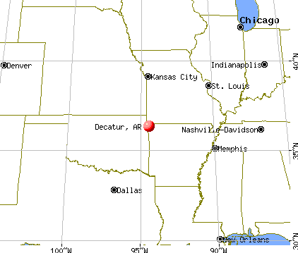
Nearest city with pop. 50,000+: Fayetteville, AR  (24.5 miles , pop. 58,047).
Nearest city with pop. 200,000+: Tulsa, OK (83.8 miles , pop. 393,049).
Nearest city with pop. 1,000,000+: Dallas, TX (278.4 miles , pop. 1,188,580).
Nearest cities:
), ), )Latitude: 36.34 N, Longitude: 94.46 W
Area code: 479
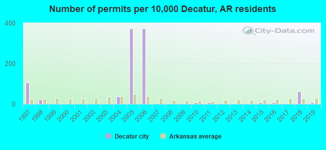
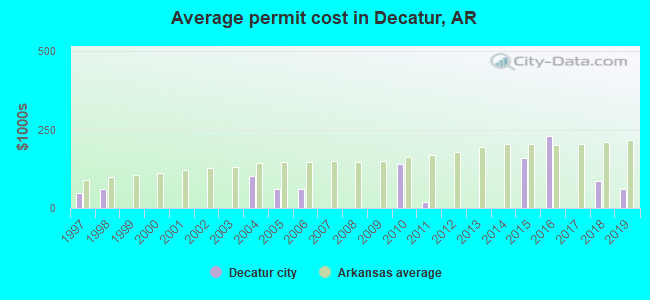
Single-family new house construction building permits:
- 2019: 1 building, cost: $62,300
- 2018: 8 buildings, average cost: $86,700
- 2016: 1 building, cost: $230,300
- 2015: 1 building, cost: $161,200
- 2011: 1 building, cost: $20,000
- 2010: 1 building, cost: $140,000
- 2006: 49 buildings, average cost: $60,000
- 2005: 49 buildings, average cost: $60,000
- 2004: 5 buildings, average cost: $101,200
- 1998: 3 buildings, average cost: $60,700
- 1997: 14 buildings, average cost: $48,100
| Here: | 2.5% |
| Arkansas: | 3.4% |
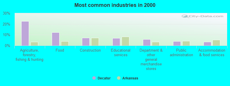
- Agriculture, forestry, fishing & hunting (22.5%)
- Food (12.3%)
- Construction (7.3%)
- Educational services (6.8%)
- Department & other general merchandise stores (6.0%)
- Public administration (4.0%)
- Accommodation & food services (3.5%)
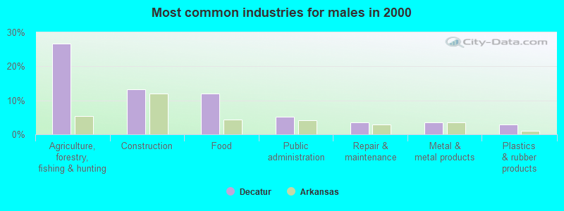
- Agriculture, forestry, fishing & hunting (26.6%)
- Construction (13.2%)
- Food (12.0%)
- Public administration (5.1%)
- Repair & maintenance (3.6%)
- Metal & metal products (3.6%)
- Plastics & rubber products (3.0%)
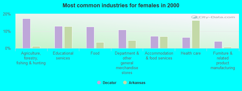
- Agriculture, forestry, fishing & hunting (17.4%)
- Educational services (13.0%)
- Food (12.6%)
- Department & other general merchandise stores (10.7%)
- Accommodation & food services (7.0%)
- Health care (6.3%)
- Furniture & related product manufacturing (4.1%)
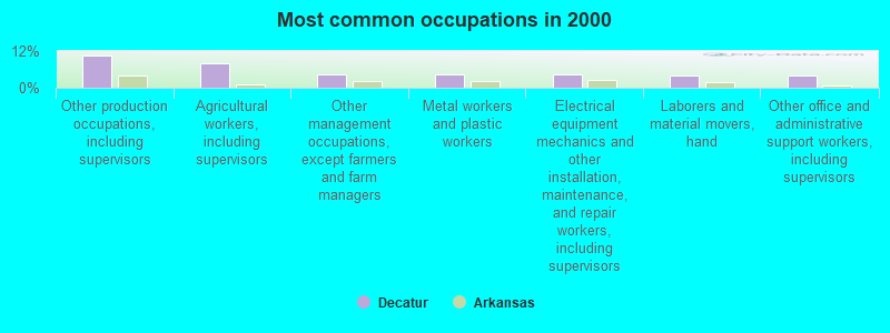
- Other production occupations, including supervisors (10.6%)
- Agricultural workers, including supervisors (8.1%)
- Other management occupations, except farmers and farm managers (4.5%)
- Metal workers and plastic workers (4.5%)
- Electrical equipment mechanics and other installation, maintenance, and repair workers, including supervisors (4.3%)
- Laborers and material movers, hand (4.1%)
- Other office and administrative support workers, including supervisors (4.0%)
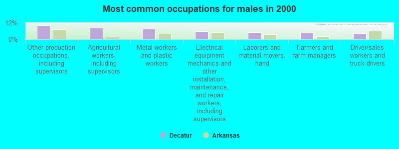
- Other production occupations, including supervisors (10.2%)
- Agricultural workers, including supervisors (8.4%)
- Metal workers and plastic workers (7.5%)
- Electrical equipment mechanics and other installation, maintenance, and repair workers, including supervisors (6.0%)
- Laborers and material movers, hand (5.1%)
- Farmers and farm managers (4.8%)
- Driver/sales workers and truck drivers (4.2%)
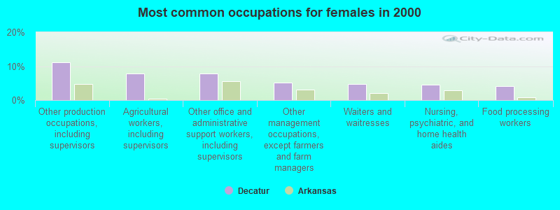
- Other production occupations, including supervisors (11.1%)
- Agricultural workers, including supervisors (7.8%)
- Other office and administrative support workers, including supervisors (7.8%)
- Other management occupations, except farmers and farm managers (5.2%)
- Waiters and waitresses (4.8%)
- Nursing, psychiatric, and home health aides (4.4%)
- Food processing workers (4.1%)
Average climate in Decatur, Arkansas
Based on data reported by over 4,000 weather stations


|
|


(lower is better)
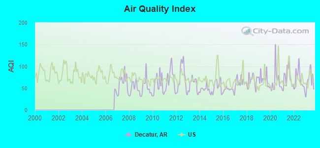
Air Quality Index (AQI) level in 2023 was 67.7. This is about average.
| City: | 67.7 |
| U.S.: | 72.6 |
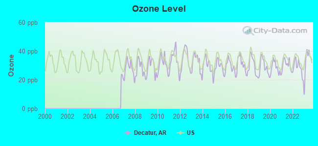
Ozone [ppb] level in 2023 was 33.0. This is about average. Closest monitor was 21.9 miles away from the city center.
| City: | 33.0 |
| U.S.: | 33.3 |
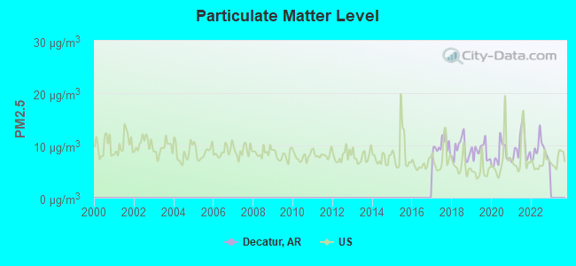
Particulate Matter (PM2.5) [µg/m3] level in 2022 was 8.95. This is about average. Closest monitor was 14.4 miles away from the city center.
| City: | 8.95 |
| U.S.: | 8.11 |
Tornado activity:
Decatur-area historical tornado activity is near Arkansas state average. It is 112% greater than the overall U.S. average.
On 3/12/2006, a category F3 (max. wind speeds 158-206 mph) tornado 7.9 miles away from the Decatur city center injured 12 people and caused $5 million in damages.
On 10/8/1970, a category F3 tornado 8.4 miles away from the city center injured 4 people and caused between $50,000 and $500,000 in damages.
Earthquake activity:
Decatur-area historical earthquake activity is significantly above Arkansas state average. It is 663% greater than the overall U.S. average.On 9/3/2016 at 12:02:44, a magnitude 5.8 (5.8 MW, Depth: 3.5 mi, Class: Moderate, Intensity: VI - VII) earthquake occurred 137.8 miles away from the city center
On 11/6/2011 at 03:53:10, a magnitude 5.7 (5.7 MW, Depth: 3.2 mi) earthquake occurred 140.8 miles away from the city center
On 11/7/2016 at 01:44:24, a magnitude 5.0 (5.0 MW, Depth: 2.8 mi) earthquake occurred 133.2 miles away from Decatur center
On 11/5/2011 at 07:12:45, a magnitude 4.8 (4.8 MW, Depth: 1.9 mi, Class: Light, Intensity: IV - V) earthquake occurred 140.2 miles away from the city center
On 11/8/2011 at 02:46:57, a magnitude 4.8 (4.8 MW, Depth: 3.1 mi) earthquake occurred 142.0 miles away from Decatur center
On 2/28/2011 at 05:00:50, a magnitude 4.7 (4.7 MW, Depth: 2.0 mi) earthquake occurred 139.2 miles away from the city center
Magnitude types: moment magnitude (MW)
Natural disasters:
The number of natural disasters in Benton County (20) is greater than the US average (15).Major Disasters (Presidential) Declared: 14
Emergencies Declared: 4
Causes of natural disasters: Floods: 13, Storms: 13, Tornadoes: 6, Winter Storms: 4, Winds: 2, Drought: 1, Hurricane: 1, Other: 1 (Note: some incidents may be assigned to more than one category).

Hospitals and medical centers near Decatur:
- OZARKS COMMUNITY HOSPITAL OF GRAVETTE Critical Access Hospitals (about 5 miles away; GRAVETTE, AR)
- DIALYSIS CENTER OF SILOAM SPRINGS (Dialysis Facility, about 12 miles away; SILOAM SPRINGS, AR)
- SILOAM SPRINGS NURSING AND REHABILITATION CENTER (Nursing Home, about 12 miles away; SILOAM SPRINGS, AR)
- HIGHLAND HEALTHCARE AND REHABILITATION CENTER (Nursing Home, about 12 miles away; BELLA VISTA, AR)
- BENTONVILLE MANOR (Nursing Home, about 14 miles away; BENTONVILLE, AR)
- BENTONVILLE MANOR NURSING HOME (Nursing Home, about 14 miles away; BENTONVILLE, AR)
- DAVITA - BENTONVILLE (Dialysis Facility, about 15 miles away; BENTONVILLE, AR)
Airports located in Decatur:
- Crystal Lake Airport (5M5) (Runways: 1, Itinerant Ops: 250, Local Ops: 250)
Colleges/universities with over 2000 students nearest to Decatur:
- John Brown University (about 12 miles; Siloam Springs, AR; Full-time enrollment: 2,097)
- NorthWest Arkansas Community College (about 16 miles; Bentonville, AR; FT enrollment: 5,634)
- University of Arkansas (about 25 miles; Fayetteville, AR; FT enrollment: 22,163)
- Crowder College (about 34 miles; Neosho, MO; FT enrollment: 3,675)
- Northeastern State University (about 41 miles; Tahlequah, OK; FT enrollment: 6,895)
- Northeastern Oklahoma A&M College (about 44 miles; Miami, OK; FT enrollment: 2,075)
- Missouri Southern State University (about 53 miles; Joplin, MO; FT enrollment: 4,456)
Points of interest:
Notable locations in Decatur: Decatur Police Department (A), Decatur Fire Station (B). Display/hide their locations on the map
Cemetery: Decatur Cemetery (1). Display/hide its location on the map
Park in Decatur: Decatur Park (1). Display/hide its location on the map
Drinking water stations with addresses in Decatur and their reported violations in the past:
DECATUR WATERWORKS (Population served: 2,050, Purch surface water):Past monitoring violations:
- One minor monitoring violation
| This city: | 2.9 people |
| Arkansas: | 2.5 people |
| This city: | 67.2% |
| Whole state: | 67.6% |
| This city: | 9.4% |
| Whole state: | 5.7% |
Likely homosexual households (counted as self-reported same-sex unmarried-partner households)
- Lesbian couples: 0.5% of all households
- Gay men: 0.0% of all households
Banks with branches in Decatur (2011 data):
- Decatur State Bank: at 372 Sh 59 N, branch established on 1954/08/05. Info updated 2006/11/03: Bank assets: $166.0 mil, Deposits: $152.3 mil, local headquarters, negative income in the last year, Agricultural Specialization, 3 total offices, Holding Company: Peterson Holding Company
For population 15 years and over in Decatur:
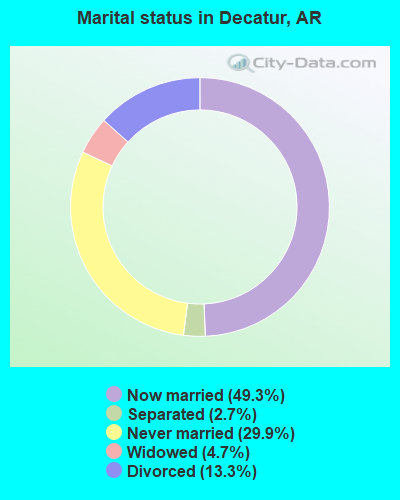
- Never married: 29.9%
- Now married: 49.3%
- Separated: 2.7%
- Widowed: 4.7%
- Divorced: 13.3%
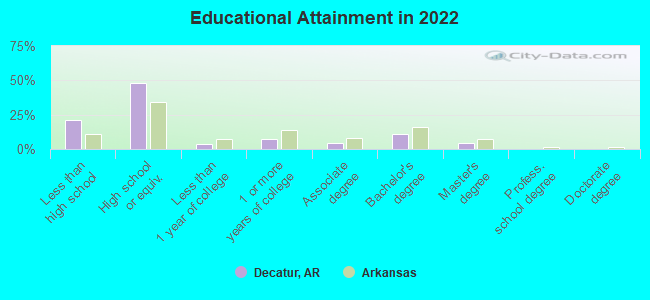
For population 25 years and over in Decatur:
- High school or higher: 79.0%
- Bachelor's degree or higher: 13.6%
- Graduate or professional degree: 4.1%
- Unemployed: 4.9%
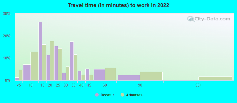
- Mean travel time to work (commute): 23.3 minutes
| Here: | 12.7 |
| Arkansas average: | 11.4 |
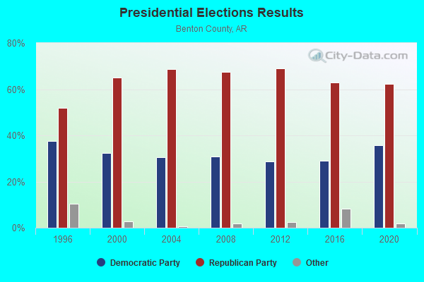
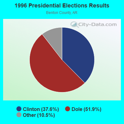
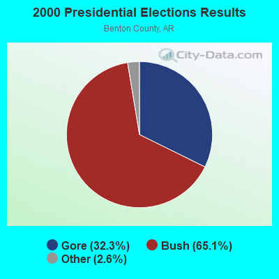
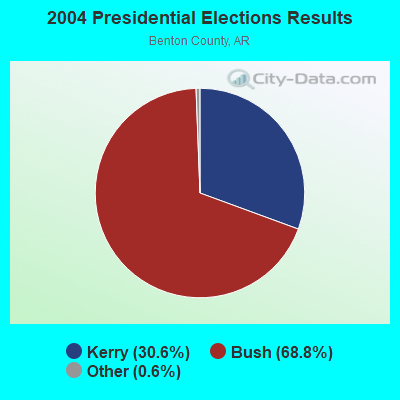


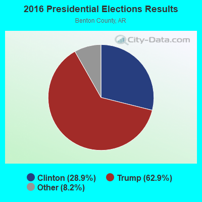
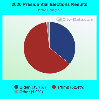
Graphs represent county-level data. Detailed 2008 Election Results
Neighborhoods in Decatur:
(Decatur, Arkansas Neighborhood Map)Religion statistics for Decatur, AR (based on Benton County data)
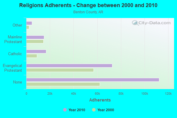
| Religion | Adherents | Congregations |
|---|---|---|
| Evangelical Protestant | 72,566 | 228 |
| Catholic | 16,757 | 4 |
| Mainline Protestant | 14,839 | 43 |
| Other | 4,857 | 20 |
| None | 112,320 | - |
Food Environment Statistics:
| This county: | 1.23 / 10,000 pop. |
| State: | 2.02 / 10,000 pop. |
| Benton County: | 0.30 / 10,000 pop. |
| State: | 0.25 / 10,000 pop. |
| This county: | 0.35 / 10,000 pop. |
| Arkansas: | 0.59 / 10,000 pop. |
| This county: | 3.90 / 10,000 pop. |
| Arkansas: | 4.94 / 10,000 pop. |
| Benton County: | 6.42 / 10,000 pop. |
| State: | 6.66 / 10,000 pop. |
| Benton County: | 7.9% |
| State: | 9.8% |
| Benton County: | 27.0% |
| State: | 29.1% |
| Benton County: | 15.4% |
| Arkansas: | 13.6% |
Health and Nutrition:
| This city: | 44.2% |
| Arkansas: | 48.2% |
| Decatur: | 40.4% |
| Arkansas: | 44.2% |
| Decatur: | 28.5 |
| Arkansas: | 28.9 |
| This city: | 23.5% |
| State: | 21.6% |
| This city: | 10.2% |
| Arkansas: | 11.3% |
| This city: | 6.7 |
| Arkansas: | 6.8 |
| Decatur: | 30.3% |
| Arkansas: | 34.0% |
| Here: | 53.4% |
| State: | 54.4% |
| This city: | 78.8% |
| Arkansas: | 78.0% |
More about Health and Nutrition of Decatur, AR Residents
| Local government employment and payroll (March 2022) | |||||
| Function | Full-time employees | Monthly full-time payroll | Average yearly full-time wage | Part-time employees | Monthly part-time payroll |
|---|---|---|---|---|---|
| Water Supply | 9 | $30,108 | $40,144 | 0 | $0 |
| Sewerage | 7 | $23,855 | $40,894 | 0 | $0 |
| Police Protection - Officers | 7 | $26,148 | $44,825 | 1 | $1,235 |
| Judicial and Legal | 3 | $13,992 | $55,968 | 5 | $1,465 |
| Financial Administration | 1 | $6,197 | $74,364 | 4 | $6,509 |
| Firefighters | 0 | $0 | 25 | $6,472 | |
| Other Government Administration | 0 | $0 | 14 | $5,311 | |
| Local Libraries | 0 | $0 | 1 | $2,561 | |
| Totals for Government | 27 | $100,300 | $44,578 | 50 | $23,553 |
Decatur government finances - Expenditure in 2017 (per resident):
- Current Operations - Sewerage: $1,477,000 ($847.39)
Water Utilities: $1,477,000 ($847.39)
Police Protection: $761,000 ($436.60)
Local Fire Protection: $293,000 ($168.10)
Regular Highways: $205,000 ($117.61)
Central Staff Services: $203,000 ($116.47)
Parks and Recreation: $147,000 ($84.34)
Solid Waste Management: $64,000 ($36.72)
Judicial and Legal Services: $59,000 ($33.85)
Financial Administration: $5,000 ($2.87)
- Other Capital Outlay - Water Utilities: $197,000 ($113.02)
- Water Utilities - Interest on Debt: $531,000 ($304.65)
Decatur government finances - Revenue in 2017 (per resident):
- Charges - Sewerage: $1,781,000 ($1021.80)
Solid Waste Management: $73,000 ($41.88)
Other: $20,000 ($11.47)
Regular Highways: $15,000 ($8.61)
- Federal Intergovernmental - General Local Government Support: $1,000 ($0.57)
- Local Intergovernmental - General Local Government Support: $317,000 ($181.87)
- Miscellaneous - General Revenue - Other: $197,000 ($113.02)
Fines and Forfeits: $156,000 ($89.50)
Interest Earnings: $5,000 ($2.87)
- Revenue - Water Utilities: $2,482,000 ($1423.98)
- State Intergovernmental - Highways: $112,000 ($64.26)
General Local Government Support: $59,000 ($33.85)
- Tax - General Sales and Gross Receipts: $575,000 ($329.89)
Property: $147,000 ($84.34)
Public Utilities Sales: $84,000 ($48.19)
Occupation and Business License - Other: $17,000 ($9.75)
Decatur government finances - Debt in 2017 (per resident):
- Long Term Debt - Outstanding Unspecified Public Purpose: $12,394,000 ($7110.73)
Beginning Outstanding - Unspecified Public Purpose: $11,735,000 ($6732.64)
Issue, Unspecified Public Purpose: $9,870,000 ($5662.65)
Retired Unspecified Public Purpose: $9,211,000 ($5284.57)
Decatur government finances - Cash and Securities in 2017 (per resident):
- Bond Funds - Cash and Securities: $462,000 ($265.06)
- Other Funds - Cash and Securities: $2,874,000 ($1648.88)
Strongest AM radio stations in Decatur:
- KUOA (1290 AM; 5 kW; SILOAM SPRINGS, AR; Owner: KUOA, INC.)
- KFAY (1030 AM; 10 kW; FARMINGTON, AR; Owner: CUMULUS LICENSING CORP)
- KURM (790 AM; 5 kW; ROGERS, AR; Owner: KERM, INC)
- KREB (1190 AM; daytime; 2 kW; BENTONVILLE/BELLA VI, AR; Owner: BUTLER BROADCASTING COMPANY, LLC)
- KFAQ (1170 AM; 50 kW; TULSA, OK; Owner: JOURNAL BROADCAST CORPORATION)
- KRMG (740 AM; 50 kW; TULSA, OK; Owner: CXR HOLDINGS, INC.)
- KBTN (1420 AM; 10 kW; NEOSHO, MO; Owner: PETRACOM OF JOPLIN, L.L.C.)
- KZRA (1590 AM; 2 kW; SPRINGDALE, AR; Owner: CUMULUS LICENSING CORP.)
- KZAR (1390 AM; 1 kW; ROGERS, AR; Owner: BUTLER BROADCASTING COMPANY, LLC)
- KTBZ (1430 AM; 25 kW; TULSA, OK; Owner: CLEAR CHANNEL BROADCASTING LICENSES, INC.)
- WMBH (1560 AM; 10 kW; JOPLIN, MO)
- KGGF (690 AM; 10 kW; COFFEYVILLE, KS; Owner: KGGF-KUSN, INC.)
- KMUS (1380 AM; 20 kW; MUSKOGEE, OK; Owner: ABC, INC.)
Strongest FM radio stations in Decatur:
- KBVA (106.5 FM; BELLA VISTA, AR; Owner: GAYLA JOY HENDREN)
- KURM-FM (100.3 FM; SOUTHWEST CITY, MO; Owner: KERM, INC.)
- KLRC (101.1 FM; SILOAM SPRINGS, AR; Owner: JOHN BROWN UNIVERSITY)
- KMCK-FM (105.7 FM; SILOAM SPRINGS, AR; Owner: CUMULUS LICENSING CORP.)
- KEZA (107.9 FM; FAYETTEVILLE, AR; Owner: CAPSTAR TX LIMITED PARTNERSHIP)
- KMXF (101.9 FM; LOWELL, AR; Owner: CAPSTAR TX LIMITED PARTNERSHIP)
- KAYH (89.3 FM; FAYETTEVILLE, AR; Owner: FAMILY VISION MINISTRIES, INC.)
- KSEC (95.7 FM; BENTONVILLE, AR; Owner: BENTONVILLE BROADCASTING, LLC)
- KUAF (91.3 FM; FAYETTEVILLE, AR; Owner: BOARD OF TRUSTEES OF THE UNIVERSITY OF ARKANSAS)
- K203CE (88.5 FM; SPRINGDALE, AR; Owner: BIBLE BROADCASTING NETWORK, INC.)
- KAMO-FM (94.3 FM; ROGERS, AR; Owner: CUMULUS LICENSING CORP.)
- KXNA (104.9 FM; SPRINGDALE, AR; Owner: BUTLER BROADCASTING COMPANY, LLC)
- KDAB (94.9 FM; PRAIRIE GROVE, AR; Owner: CUMULUS LICENSING CORP.)
- KFAY-FM (98.3 FM; BENTONVILLE, AR; Owner: CUMULUS LICENSING CORP)
- KKIX (103.9 FM; FAYETTEVILLE, AR; Owner: CAPSTAR TX LIMITED PARTNERSHIP)
- KIGL (93.3 FM; SELIGMAN, MO; Owner: CAPSTAR TX LIMITED PARTNERSHIP)
- KAPG (88.1 FM; BENTONVILLE, AR; Owner: AMERICAN FAMILY ASSOCIATION)
- KKEG (92.1 FM; FAYETTEVILLE, AR; Owner: CUMULUS LICENSING CORP)
- K244DS (96.7 FM; FAYETTEVILLE, AR; Owner: BUTLER BROADCASTING COMPANY, LLC)
- KBNV (90.1 FM; FAYETTEVILLE, AR; Owner: AMERICAN FAMILY ASSOCIATION)
TV broadcast stations around Decatur:
- K45EI (Channel 45; BENTONVILLE & ROGERS, AR; Owner: VICTORY COMMUNICATIONS, INC.)
- K09VM (Channel 9; ANDERSON, ETC., MO; Owner: GARY M./DEBORAH R. KENNY)
- KSBN-TV (Channel 57; SPRINGDALE, AR; Owner: TOTAL LIFE COMMUNITY EDUCATIONAL FOUNDATION)
- K67EO (Channel 67; BENTONVILLE, AR; Owner: NEW YORK TIMES MANAGEMENT SERVICES)
- K33FG (Channel 33; SILOAM SPRINGS, AR; Owner: FORT SMITH 46, INC.)
- KFAA (Channel 51; ROGERS, AR; Owner: J.D.G. TELEVISION, INC.)
- K14IT (Channel 14; BENTONVILLE, AR; Owner: FORT SMITH 46, INC.)
- K62DQ (Channel 62; FAYETTEVILLE, ETC., AR; Owner: NEW YORK TIMES MANAGEMENT SERVICES)
- KAFT (Channel 13; FAYETTEVILLE, AR; Owner: ARKANSAS EDUCATIONAL TELEVISION COMMISSION)
- K64FO (Channel 64; FAYETTEVILLE, AR; Owner: FORT SMITH 46, INC.)
- KHOG-TV (Channel 29; FAYETTEVILLE, AR; Owner: KHBS HEARST-ARGYLE TELEVISION, INC.)
- K15DR (Channel 15; SPRINGDALE, AR; Owner: FORT SMITH 46, INC.)
- K59ES (Channel 59; HINDSVILLE, AR; Owner: FORT SMITH 46, INC.)
- Decatur, Arkansas
- Fatal accident count8
- Vehicles involved in fatal accidents11
- Fatal accidents involving drunk persons:3
- Fatalities9
- Persons involved in fatal accidents20
- Pedestrians involved in fatal accidents0
- Arkansas average
- Fatal accident count3769
- Vehicles involved in fatal accidents5633
- Fatal accidents involving drunk persons1437
- Fatalities4269
- Persons involved in fatal accidents9632
- Pedestrians involved in fatal accidents214
- National Bridge Inventory (NBI) Statistics
- 31Number of bridges
- 397ft / 121mTotal length
- $4,538,000Total costs
- 73,229Total average daily traffic
- 5,242Total average daily truck traffic
- New bridges - historical statistics
- 21920-1929
- 21930-1939
- 31940-1949
- 71950-1959
- 11960-1969
- 41970-1979
- 71980-1989
- 31990-1999
- 12000-2009
FCC Registered Cell Phone Towers:
1 (See the full list of FCC Registered Cell Phone Towers in Decatur)FCC Registered Antenna Towers:
75 (See the full list of FCC Registered Antenna Towers)FCC Registered Commercial Land Mobile Towers:
1- 1/2 Mile W Hwy 59 S (Lat: 36.305917 Lon: -94.458278), Structure height: 122 m, Call Sign: KPK527,
Assigned Frequencies: 450.980 MHz, Grant Date: 06/29/1992, Registrant: Gayla Joy Hendren, Route 5, Hwy 72 East, Gravette, AR 72736
FCC Registered Broadcast Land Mobile Towers:
5- .2 Mi W St Hwy 59 2 Mi S (Lat: 36.301194 Lon: -94.451056), Type: Tower, Structure height: 106.7 m, Overall height: 113 m, Call Sign: KDV581,
Assigned Frequencies: 160.260 MHz, 160.305 MHz, 160.350 MHz, 160.740 MHz, 161.250 MHz, 160.950 MHz, 161.310 MHz, Grant Date: 03/04/2014, Expiration Date: 05/08/2024, Registrant: Canadian Pacific Railway, 5th Floor - 120 South 6th Street, Minneapolis, MN 55402, Phone: (403) 319-6007, Fax: (612) 851-5688, Email:
- Peterson Feed Mill 1.7 Mi Ne (Lat: 36.357306 Lon: -94.446056), Type: Building, Structure height: 6 m, Call Sign: WPGM851,
Assigned Frequencies: 160.260 MHz, 160.350 MHz, Grant Date: 11/13/2014, Expiration Date: 02/09/2025, Registrant: Canadian Pacific Railway, 5th Floor - 120 South 6th Street, Minneapolis, MN 55402, Phone: (403) 319-6007, Fax: (612) 851-5688, Email:
- 91.4 M N Of Intersection Of Benton City 16 & 349 (Lat: 36.305000 Lon: -94.434167), Type: Tank, Structure height: 15.2 m, Overall height: 16.2 m, Call Sign: WPTF815,
Assigned Frequencies: 154.107 MHz, Grant Date: 09/01/2021, Expiration Date: 09/24/2031, Certifier: Rick Mcclain, Registrant: Business Radio Licensing, 30251 Golden Lantern, Suite E # 501, Laguna Niguel, CA 92677, Phone: (949) 348-8510, Fax: (949) 348-8514, Email:
- MOB DECATUR, Lat: 36.301167 Lon: -94.451028, Call Sign: WPUX244,
Assigned Frequencies: 452.925 MHz, 452.950 MHz, 457.925 MHz, 457.950 MHz, Grant Date: 03/04/2022, Expiration Date: 05/20/2032, Certifier: Donald R Perrilloux, Registrant: Canadian Pacific Railway, 5th Floor - 120 South 6th Street, Minneapolis, MN 55402, Phone: (403) 319-6007, Fax: (612) 851-5688, Email:
- Kcs Rr Milepost 218.4, 2 Km South Of (Lat: 36.317833 Lon: -94.454389), Type: Bant, Structure height: 1.5 m, Overall height: 2 m, Call Sign: WQFI761,
Assigned Frequencies: 160.260 MHz, 160.350 MHz, Grant Date: 04/29/2016, Expiration Date: 07/25/2026, Certifier: Mark D Mchalffey, Registrant: Canadian Pacific Railway, 5th Floor - 120 South 6th Street, Minneapolis, MN 55402, Phone: (403) 319-6007, Fax: (612) 851-5688, Email:
FCC Registered Microwave Towers:
9 (See the full list of FCC Registered Microwave Towers in this town)FCC Registered Amateur Radio Licenses:
13 (See the full list of FCC Registered Amateur Radio Licenses in Decatur)FAA Registered Aircraft Manufacturers and Dealers:
2- UNIVERSAL AVIATION LLC, Po Box 396, Decatur, AR 72722
Certificate: D004998 (LLC), Certificate Issue Date: 05/05/2020, Expiration Date: 05/04/2021 - UNIVERSAL AVIATION LLC, Po Box 396, Decatur, AR 72722
Certificate: D004998 (Corporation), Certificate Issue Date: 04/26/2017, Expiration Date: 04/25/2018
FAA Registered Aircraft:
1- Aircraft: BEECH 58 (Category: Land, Engines: 2, Seats: 6, Weight: Up to 12,499 Pounds, Speed: 165 mph), Engine: CONT MOTOR IO 520 SERIES (285 HP) (Reciprocating)
N-Number: 1175T, N1175T, N-1175T, Serial Number: TH-604, Year manufactured: 1975, Airworthiness Date: 02/24/1975
Registrant (LLC): Universal Aviation LLC, Po Box 396, Decatur, AR 72722
2002 - 2018 National Fire Incident Reporting System (NFIRS) incidents
- Fire incident types reported to NFIRS in Decatur, AR
- 8559.9%Structure Fires
- 4330.3%Outside Fires
- 96.3%Other
- 53.5%Mobile Property/Vehicle Fires
 According to the data from the years 2002 - 2018 the average number of fire incidents per year is 8. The highest number of reported fires - 29 took place in 2014, and the least - 1 in 2012. The data has a growing trend.
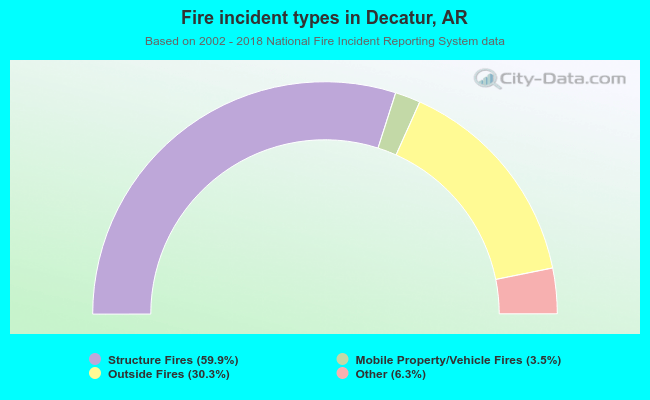 When looking into fire subcategories, the most incidents belonged to: Structure Fires (59.9%), and Outside Fires (30.3%).
| Most common first names in Decatur, AR among deceased individuals | ||
| Name | Count | Lived (average) |
|---|---|---|
| James | 20 | 70.4 years |
| William | 18 | 75.3 years |
| Mary | 11 | 73.5 years |
| John | 9 | 79.6 years |
| Charles | 8 | 77.5 years |
| Robert | 8 | 76.7 years |
| Henry | 5 | 76.0 years |
| Gladys | 5 | 74.8 years |
| Irene | 5 | 82.0 years |
| Ruth | 5 | 84.2 years |
| Most common last names in Decatur, AR among deceased individuals | ||
| Last name | Count | Lived (average) |
|---|---|---|
| Wilmoth | 17 | 76.0 years |
| Smith | 11 | 71.1 years |
| Turner | 7 | 73.9 years |
| Owens | 6 | 84.1 years |
| Johnson | 6 | 81.5 years |
| Brandon | 5 | 71.4 years |
| Jones | 5 | 68.8 years |
| Florer | 5 | 85.2 years |
| Addington | 5 | 73.0 years |
| Duncan | 5 | 82.6 years |
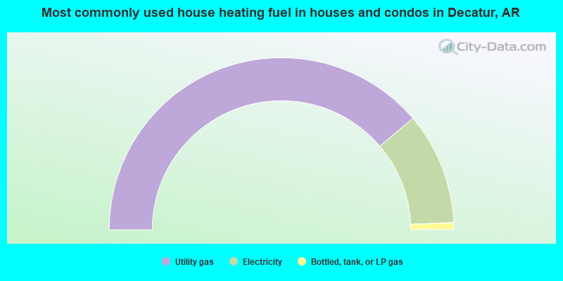
- 77.6%Utility gas
- 21.1%Electricity
- 1.3%Bottled, tank, or LP gas
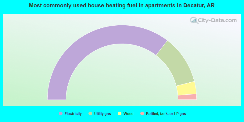
- 70.8%Electricity
- 21.3%Utility gas
- 5.4%Wood
- 2.5%Bottled, tank, or LP gas
Decatur compared to Arkansas state average:
- Unemployed percentage significantly below state average.
- Black race population percentage below state average.
- Hispanic race population percentage above state average.
- Median age significantly below state average.
- Foreign-born population percentage significantly above state average.
- Length of stay since moving in significantly above state average.
Decatur on our top lists:
- #67 on the list of "Top 101 cities with the most residents born in Nicaragua (population 500+)"
- #24 on the list of "Top 101 counties with the largest number of people moving in compared to moving out (pop. 50,000+)"
- #74 on the list of "Top 101 counties with the lowest average weight of females"
- #75 on the list of "Top 101 counties with the highest percentage of residents that drank alcohol in the past 30 days"
- #95 on the list of "Top 101 counties with the lowest percentage of residents that visited a dentist within the past year"
- #101 on the list of "Top 101 counties with the lowest percentage of residents that exercised in the past month"

|
Total of 1 patent application in 2008-2024.