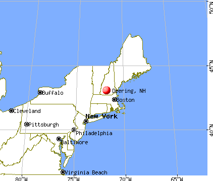
Deering, New Hampshire

Submit your own pictures of this town and show them to the world
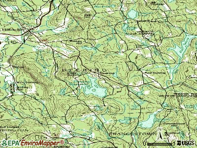
- OSM Map
- General Map
- Google Map
- MSN Map

Population change since 2000: +2.0%
 |
| Males: 990 | |
| Females: 922 |
| Median resident age: | 42.9 years |
| New Hampshire median age: | 43.9 years |
Zip codes: 03244.
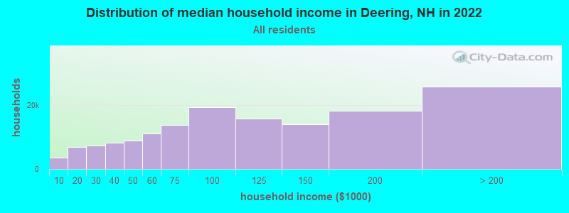
| Deering: | $88,508 |
| NH: | $89,992 |
Estimated per capita income in 2022: $41,593 (it was $20,856 in 2000)
Deering town income, earnings, and wages data
Estimated median house or condo value in 2022: $289,911 (it was $96,400 in 2000)
| Deering: | $289,911 |
| NH: | $384,700 |
Mean prices in 2022: all housing units: $411,252; detached houses: $441,251; townhouses or other attached units: $283,002; in 2-unit structures: $347,377; in 3-to-4-unit structures: $666,663; in 5-or-more-unit structures: $275,798; mobile homes: $132,093
Detailed information about poverty and poor residents in Deering, NH


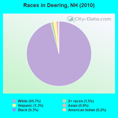
- 1,83095.7%White alone
- 291.5%Two or more races
- 251.3%Hispanic
- 180.9%Asian alone
- 50.3%Black alone
- 40.2%American Indian alone
- 10.05%Other race alone
Races in Deering detailed stats: ancestries, foreign born residents, place of birth
According to our research of New Hampshire and other state lists, there were 8 registered sex offenders living in Deering, New Hampshire as of May 17, 2024.
The ratio of all residents to sex offenders in Deering is 239 to 1.
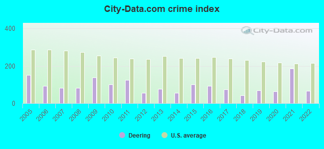
Type |
2009 |
2010 |
2011 |
2012 |
2013 |
2014 |
2015 |
2016 |
2017 |
2018 |
2019 |
2020 |
2021 |
2022 |
|---|---|---|---|---|---|---|---|---|---|---|---|---|---|---|
| Murders (per 100,000) | 0 (0.0) | 0 (0.0) | 0 (0.0) | 0 (0.0) | 0 (0.0) | 0 (0.0) | 0 (0.0) | 0 (0.0) | 0 (0.0) | 0 (0.0) | 0 (0.0) | 0 (0.0) | 0 (0.0) | 0 (0.0) |
| Rapes (per 100,000) | 0 (0.0) | 0 (0.0) | 0 (0.0) | 0 (0.0) | 0 (0.0) | 0 (0.0) | 1 (51.9) | 0 (0.0) | 0 (0.0) | 0 (0.0) | 0 (0.0) | 1 (50.6) | 4 (202.6) | 0 (0.0) |
| Robberies (per 100,000) | 0 (0.0) | 0 (0.0) | 0 (0.0) | 0 (0.0) | 0 (0.0) | 0 (0.0) | 0 (0.0) | 1 (52.0) | 0 (0.0) | 0 (0.0) | 0 (0.0) | 0 (0.0) | 0 (0.0) | 0 (0.0) |
| Assaults (per 100,000) | 6 (290.4) | 2 (104.6) | 2 (104.4) | 0 (0.0) | 3 (157.2) | 0 (0.0) | 1 (51.9) | 1 (52.0) | 2 (103.5) | 0 (0.0) | 2 (101.7) | 0 (0.0) | 1 (50.7) | 3 (156.9) |
| Burglaries (per 100,000) | 9 (435.6) | 7 (366.1) | 14 (731.1) | 6 (312.5) | 3 (157.2) | 4 (211.0) | 2 (103.8) | 5 (259.9) | 7 (362.1) | 3 (154.8) | 2 (101.7) | 0 (0.0) | 1 (50.7) | 2 (104.6) |
| Thefts (per 100,000) | 19 (919.7) | 26 (1,360) | 23 (1,201) | 14 (729.2) | 14 (733.8) | 15 (791.1) | 16 (830.3) | 22 (1,143) | 10 (517.3) | 13 (670.8) | 15 (762.6) | 8 (404.4) | 3 (152.0) | 13 (679.9) |
| Auto thefts (per 100,000) | 3 (145.2) | 0 (0.0) | 1 (52.2) | 1 (52.1) | 1 (52.4) | 2 (105.5) | 2 (103.8) | 1 (52.0) | 2 (103.5) | 1 (51.6) | 3 (152.5) | 2 (101.1) | 1 (50.7) | 0 (0.0) |
| Arson (per 100,000) | 1 (48.4) | 1 (52.3) | 1 (52.2) | 1 (52.1) | 0 (0.0) | 0 (0.0) | 0 (0.0) | 1 (52.0) | 0 (0.0) | 1 (51.6) | 0 (0.0) | 0 (0.0) | 0 (0.0) | 0 (0.0) |
| City-Data.com crime index | 137.0 | 100.9 | 124.3 | 55.2 | 76.0 | 54.9 | 100.7 | 94.1 | 75.0 | 41.8 | 70.2 | 64.7 | 185.9 | 65.9 |
The City-Data.com crime index weighs serious crimes and violent crimes more heavily. Higher means more crime, U.S. average is 246.1. It adjusts for the number of visitors and daily workers commuting into cities.
Crime rate in Deering detailed stats: murders, rapes, robberies, assaults, burglaries, thefts, arson
Full-time law enforcement employees in 2021, including police officers: 2 (2 officers - 2 male; 0 female).
| Officers per 1,000 residents here: | 1.01 |
| New Hampshire average: | 2.14 |
 Recent articles from our blog. Our writers, many of them Ph.D. graduates or candidates, create easy-to-read articles on a wide variety of topics.


Latest news from Deering, NH collected exclusively by city-data.com from local newspapers, TV, and radio stations
Ancestries: English (20.5%), Irish (17.5%), French (15.5%), German (11.5%), French Canadian (8.7%), Italian (7.3%).
Current Local Time: EST time zone
Incorporated in 1774
Elevation: 1078 feet
Land area: 30.8 square miles.
Population density: 62 people per square mile (very low).
48 residents are foreign born (1.1% Europe, 0.7% North America, 0.3% Asia).
| This town: | 2.6% |
| New Hampshire: | 4.4% |
| Deering town: | 2.4% ($2,307) |
| New Hampshire: | 2.3% ($2,946) |
Nearest city with pop. 50,000+: Manchester, NH  (21.2 miles , pop. 107,006).
Nearest city with pop. 200,000+: Boston, MA (64.9 miles , pop. 589,141).
Nearest city with pop. 1,000,000+: Bronx, NY (185.8 miles , pop. 1,332,650).
Nearest cities:
), ), )Latitude: 43.07 N, Longitude: 71.85 W
Area code commonly used in this area: 603

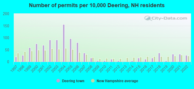
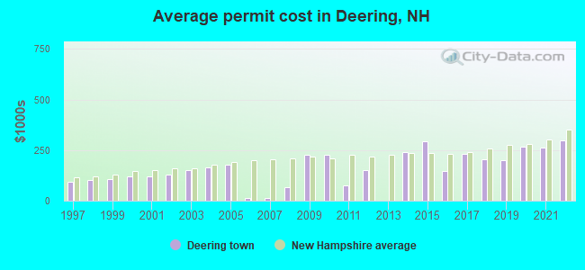
Single-family new house construction building permits:
- 2022: 5 buildings, average cost: $298,700
- 2021: 6 buildings, average cost: $262,500
- 2020: 6 buildings, average cost: $265,300
- 2019: 1 building, cost: $200,000
- 2018: 7 buildings, average cost: $205,000
- 2017: 3 buildings, average cost: $229,800
- 2016: 2 buildings, average cost: $147,500
- 2015: 3 buildings, average cost: $291,700
- 2014: 1 building, cost: $241,400
- 2012: 1 building, cost: $150,000
- 2011: 2 buildings, average cost: $75,000
- 2010: 1 building, cost: $225,300
- 2009: 1 building, cost: $225,300
- 2008: 3 buildings, average cost: $66,700
- 2007: 7 buildings, average cost: $14,300
- 2006: 15 buildings, average cost: $13,300
- 2005: 18 buildings, average cost: $177,500
- 2004: 29 buildings, average cost: $163,600
- 2003: 17 buildings, average cost: $153,100
- 2002: 17 buildings, average cost: $130,700
- 2001: 13 buildings, average cost: $121,400
- 2000: 14 buildings, average cost: $118,000
- 1999: 11 buildings, average cost: $109,200
- 1998: 5 buildings, average cost: $101,700
- 1997: 4 buildings, average cost: $91,700
| Here: | 1.6% |
| New Hampshire: | 2.5% |
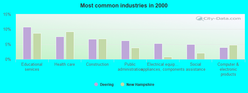
- Educational services (10.8%)
- Health care (7.6%)
- Construction (6.8%)
- Public administration (6.3%)
- Electrical equipment, appliances, components (5.2%)
- Social assistance (4.9%)
- Computer & electronic products (3.9%)
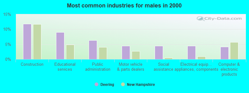
- Construction (11.8%)
- Educational services (9.0%)
- Public administration (6.4%)
- Motor vehicle & parts dealers (4.5%)
- Social assistance (4.5%)
- Electrical equipment, appliances, components (4.5%)
- Computer & electronic products (4.1%)
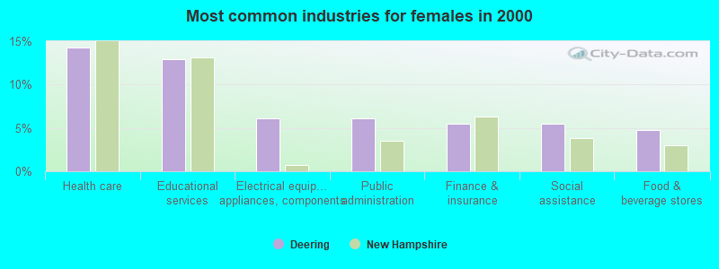
- Health care (14.3%)
- Educational services (13.0%)
- Electrical equipment, appliances, components (6.1%)
- Public administration (6.1%)
- Finance & insurance (5.5%)
- Social assistance (5.5%)
- Food & beverage stores (4.8%)
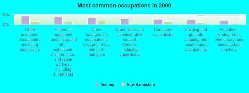
- Other production occupations, including supervisors (6.6%)
- Electrical equipment mechanics and other installation, maintenance, and repair workers, including supervisors (5.7%)
- Other management occupations, except farmers and farm managers (5.3%)
- Other office and administrative support workers, including supervisors (4.4%)
- Computer specialists (4.2%)
- Building and grounds cleaning and maintenance occupations (3.6%)
- Preschool, kindergarten, elementary, and middle school teachers (3.0%)
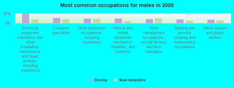
- Electrical equipment mechanics and other installation, maintenance, and repair workers, including supervisors (9.9%)
- Computer specialists (5.8%)
- Other production occupations, including supervisors (5.2%)
- Vehicle and mobile equipment mechanics, installers, and repairers (5.0%)
- Other management occupations, except farmers and farm managers (4.5%)
- Building and grounds cleaning and maintenance occupations (4.3%)
- Metal workers and plastic workers (3.9%)
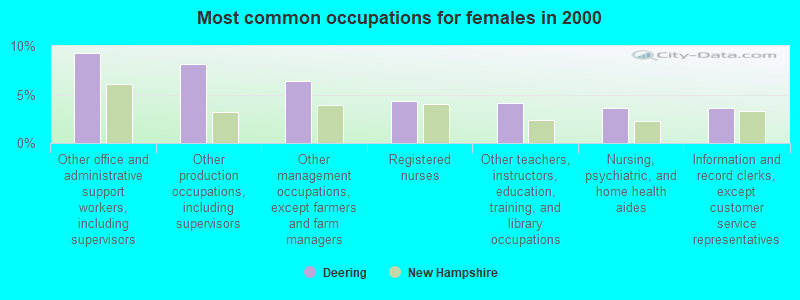
- Other office and administrative support workers, including supervisors (9.3%)
- Other production occupations, including supervisors (8.2%)
- Other management occupations, except farmers and farm managers (6.4%)
- Registered nurses (4.3%)
- Other teachers, instructors, education, training, and library occupations (4.1%)
- Nursing, psychiatric, and home health aides (3.6%)
- Information and record clerks, except customer service representatives (3.6%)
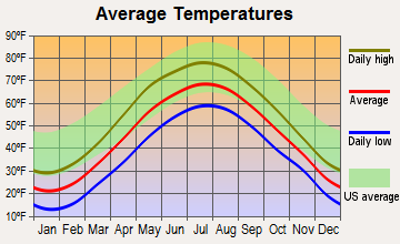
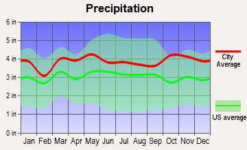
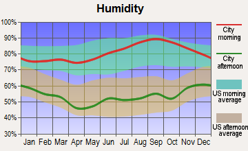
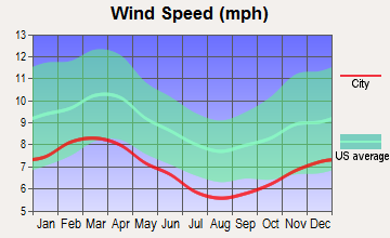
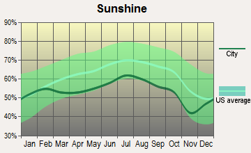
Average climate in Deering, New Hampshire
Based on data reported by over 4,000 weather stations


(lower is better)
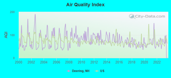
Air Quality Index (AQI) level in 2022 was 64.4. This is about average.
| City: | 64.4 |
| U.S.: | 72.6 |
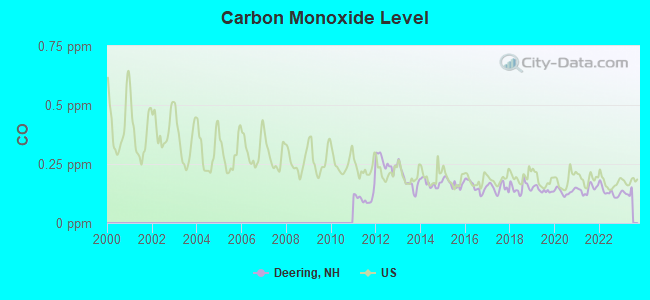
Carbon Monoxide (CO) [ppm] level in 2022 was 0.131. This is significantly better than average. Closest monitor was 13.1 miles away from the city center.
| City: | 0.131 |
| U.S.: | 0.251 |
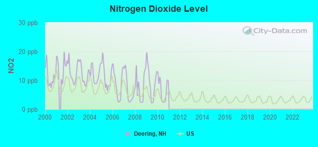
Nitrogen Dioxide (NO2) [ppb] level in 2010 was 6.81. This is worse than average. Closest monitor was 14.7 miles away from the city center.
| City: | 6.81 |
| U.S.: | 5.11 |
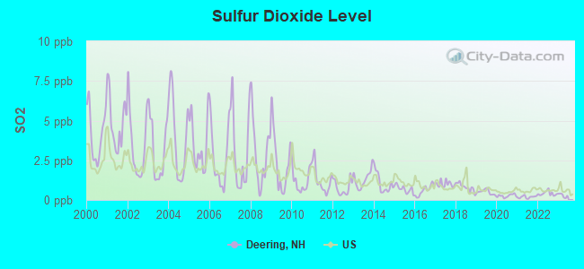
Sulfur Dioxide (SO2) [ppb] level in 2022 was 0.411. This is significantly better than average. Closest monitor was 13.1 miles away from the city center.
| City: | 0.411 |
| U.S.: | 1.515 |
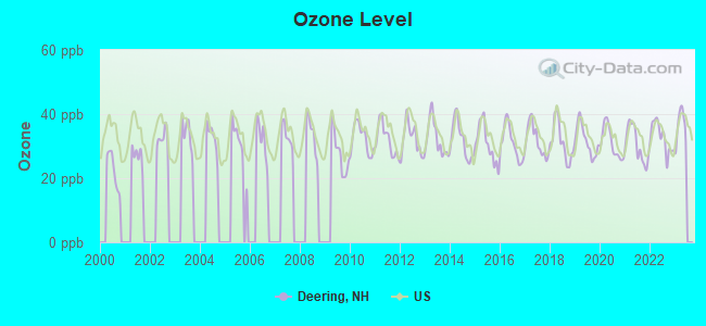
Ozone [ppb] level in 2022 was 32.6. This is about average. Closest monitor was 14.7 miles away from the city center.
| City: | 32.6 |
| U.S.: | 33.3 |
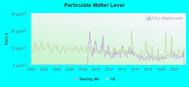
Particulate Matter (PM2.5) [µg/m3] level in 2022 was 4.69. This is significantly better than average. Closest monitor was 14.7 miles away from the city center.
| City: | 4.69 |
| U.S.: | 8.11 |
Tornado activity:
Deering-area historical tornado activity is slightly above New Hampshire state average. It is 35% smaller than the overall U.S. average.
On 6/9/1953, a category F4 (max. wind speeds 207-260 mph) tornado 44.7 miles away from the Deering town center killed 90 people and injured 1228 people and caused between $50,000,000 and $500,000,000 in damages.
On 5/31/1998, a category F2 (max. wind speeds 113-157 mph) tornado 5.7 miles away from the town center caused $30,000 in damages.
Earthquake activity:
Deering-area historical earthquake activity is significantly above New Hampshire state average. It is 71% smaller than the overall U.S. average.On 4/20/2002 at 10:50:47, a magnitude 5.3 (5.3 ML, Depth: 3.0 mi, Class: Moderate, Intensity: VI - VII) earthquake occurred 135.6 miles away from the city center
On 10/7/1983 at 10:18:46, a magnitude 5.3 (5.1 MB, 5.3 LG, 5.1 ML) earthquake occurred 138.9 miles away from the city center
On 4/20/2002 at 10:50:47, a magnitude 5.2 (5.2 MB, 4.2 MS, 5.2 MW, 5.0 MW) earthquake occurred 135.0 miles away from Deering center
On 1/19/1982 at 00:14:42, a magnitude 4.7 (4.5 MB, 4.7 MD, 4.5 LG, Class: Light, Intensity: IV - V) earthquake occurred 32.1 miles away from the city center
On 10/16/2012 at 23:12:25, a magnitude 4.7 (4.7 ML, Depth: 10.0 mi) earthquake occurred 70.3 miles away from Deering center
On 10/2/1994 at 11:27:22, a magnitude 3.7 (3.5 LG, 3.7 LG, Depth: 6.2 mi, Class: Light, Intensity: II - III) earthquake occurred 54.7 miles away from the city center
Magnitude types: regional Lg-wave magnitude (LG), body-wave magnitude (MB), duration magnitude (MD), local magnitude (ML), surface-wave magnitude (MS), moment magnitude (MW)
Natural disasters:
The number of natural disasters in Hillsborough County (27) is a lot greater than the US average (15).Major Disasters (Presidential) Declared: 17
Emergencies Declared: 10
Causes of natural disasters: Storms: 13, Floods: 11, Winter Storms: 5, Snowstorms: 4, Hurricanes: 3, Snows: 3, Blizzard: 1, Ice Storm: 1, Snowfall: 1, Wind: 1 (Note: some incidents may be assigned to more than one category).
Hospitals and medical centers near Deering:
Colleges/universities with over 2000 students nearest to Deering:
- Saint Anselm College (about 19 miles; Manchester, NH; Full-time enrollment: 2,059)
- NHTI-Concord's Community College (about 20 miles; Concord, NH; FT enrollment: 2,865)
- Southern New Hampshire University (about 21 miles; Manchester, NH; FT enrollment: 16,552)
- Mount Washington College (about 21 miles; Manchester, NH; FT enrollment: 2,187)
- Franklin Pierce University (about 23 miles; Rindge, NH; FT enrollment: 2,139)
- Keene State College (about 24 miles; Keene, NH; FT enrollment: 5,098)
- Fitchburg State University (about 34 miles; Fitchburg, MA; FT enrollment: 5,010)
Points of interest:
Notable locations in Deering: Oxbow Campground (A), Deering Community Center (B), Deering Fire and Rescue Murdough Station (C), Deering Fire and Rescue Donovan Station (D), Deering Fire and Rescue McCallister Station (E). Display/hide their locations on the map
Church in Deering: Deering Community Church (A). Display/hide its location on the map
Cemeteries: Appleton Cemetery (1), Goodale Cemetery (2), Butler Cemetery (3), Bartlett Cemetery (4). Display/hide their locations on the map
Lakes and reservoirs: Fulton Pond (A), Mud Pond (B), Deering Reservoir (C), Dudley Pond (D). Display/hide their locations on the map
Streams, rivers, and creeks: Smith Brook (A), Patten Brook (B), North Branch River (C). Display/hide their locations on the map
Park in Deering: Deering Reserve (1). Display/hide its location on the map
Drinking water stations with addresses in Deering and their reported violations in the past:
JOHNSON CITY MHP (Population served: 45, Groundwater):Past health violations:Past monitoring violations:
- MCL, Monthly (TCR) - In OCT-2012, Contaminant: Coliform. Follow-up actions: St Public Notif requested (NOV-01-2012), St Violation/Reminder Notice (NOV-01-2012), St Public Notif received (DEC-03-2012), St Compliance achieved (MAY-15-2013)
- Monitoring, Repeat Major (TCR) - In DEC-2012, Contaminant: Coliform (TCR). Follow-up actions: St Public Notif requested (JAN-04-2013), St Violation/Reminder Notice (JAN-04-2013), St Compliance achieved (JAN-04-2013), St Public Notif received (JAN-15-2013)
- One routine major monitoring violation
| This town: | 2.5 people |
| New Hampshire: | 2.5 people |
| This town: | 72.2% |
| Whole state: | 66.3% |
| This town: | 9.3% |
| Whole state: | 8.3% |
Likely homosexual households (counted as self-reported same-sex unmarried-partner households)
- Lesbian couples: 1.2% of all households
- Gay men: 0.3% of all households
| This town: | 4.0% |
| Whole state: | 6.5% |
| This town: | 2.6% |
| Whole state: | 2.8% |
61 people in homes or halfway houses for drug/alcohol abuse in 2000
18 people in other noninstitutional group quarters in 2000
For population 15 years and over in Deering:
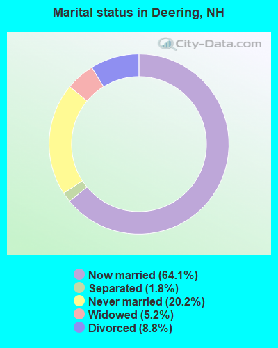
- Never married: 20.2%
- Now married: 64.1%
- Separated: 1.8%
- Widowed: 5.2%
- Divorced: 8.8%
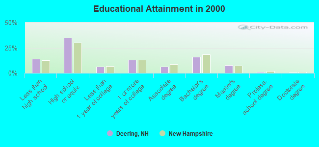
For population 25 years and over in Deering:
- High school or higher: 85.9%
- Bachelor's degree or higher: 25.5%
- Graduate or professional degree: 9.6%
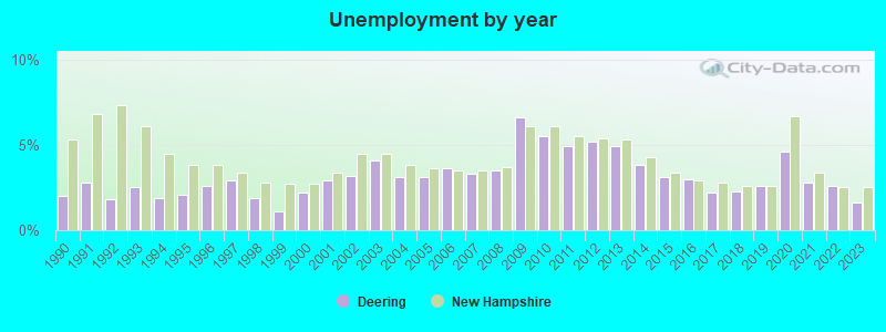
- Unemployed: 6.0%
- Mean travel time to work (commute): 30.4 minutes
| Here: | 10.5 |
| New Hampshire average: | 10.9 |


Graphs represent county-level data. Detailed 2008 Election Results
Religion statistics for Deering, NH (based on Hillsborough County data)


| Religion | Adherents | Congregations |
|---|---|---|
| Catholic | 124,993 | 40 |
| Evangelical Protestant | 20,588 | 103 |
| Mainline Protestant | 17,794 | 60 |
| Other | 7,365 | 35 |
| Orthodox | 2,990 | 7 |
| Black Protestant | - | 1 |
| None | 226,991 | - |
Food Environment Statistics:
| Hillsborough County: | 1.82 / 10,000 pop. |
| New Hampshire: | 2.14 / 10,000 pop. |
| This county: | 0.12 / 10,000 pop. |
| New Hampshire: | 0.15 / 10,000 pop. |
| Hillsborough County: | 1.65 / 10,000 pop. |
| New Hampshire: | 1.78 / 10,000 pop. |
| This county: | 2.67 / 10,000 pop. |
| New Hampshire: | 4.02 / 10,000 pop. |
| Here: | 8.23 / 10,000 pop. |
| State: | 9.70 / 10,000 pop. |
| Here: | 6.9% |
| New Hampshire: | 7.6% |
| This county: | 24.5% |
| New Hampshire: | 24.4% |
| Hillsborough County: | 15.1% |
| State: | 15.9% |
6.73% of this county's 2021 resident taxpayers lived in other counties in 2020 ($92,767 average adjusted gross income)
| Here: | 6.73% |
| New Hampshire average: | 7.66% |
0.01% of residents moved from foreign countries ($183 average AGI)
Hillsborough County: 0.01% New Hampshire average: 0.01%
Top counties from which taxpayers relocated into this county between 2020 and 2021:
| from Middlesex County, MA | |
| from Rockingham County, NH | |
| from Merrimack County, NH |
6.49% of this county's 2020 resident taxpayers moved to other counties in 2021 ($81,100 average adjusted gross income)
| Here: | 6.49% |
| New Hampshire average: | 6.80% |
0.02% of residents moved to foreign countries ($105 average AGI)
Hillsborough County: 0.02% New Hampshire average: 0.01%
Top counties to which taxpayers relocated from this county between 2020 and 2021:
| to Rockingham County, NH | |
| to Merrimack County, NH | |
| to Middlesex County, MA |
Strongest AM radio stations in Deering:
- WRKO (680 AM; 50 kW; BOSTON, MA; Owner: ENTERCOM BOSTON LICENSE, LLC)
- WGIR (610 AM; 5 kW; MANCHESTER, NH; Owner: CAPSTAR TX LIMITED PARTNERSHIP)
- WCRN (830 AM; 50 kW; WORCESTER, MA; Owner: CARTER BROADCASTING CORPORATION)
- WEEI (850 AM; 50 kW; BOSTON, MA; Owner: ENTERCOM BOSTON LICENSE, LLC)
- WNTK (1020 AM; 10 kW; NEWPORT, NH; Owner: KOOR COMMUNICATIONS, INC.)
- WNNZ (640 AM; 50 kW; WESTFIELD, MA; Owner: CLEAR CHANNEL BROADCASTING LICENSES, INC.)
- WKBR (1250 AM; 5 kW; MANCHESTER, NH; Owner: DEVON BROADCASTING COMPANY, INC.)
- WKOX (1200 AM; 50 kW; FRAMINGHAM, MA; Owner: CAPSTAR TX LIMITED PARTNERSHIP)
- WBIX (1060 AM; 40 kW; NATICK, MA; Owner: LANGER BROADCASTING CORPORATION)
- WWZN (1510 AM; 50 kW; BOSTON, MA; Owner: ROSE CITY RADIO CORPORATION)
- WVNE (760 AM; daytime; 25 kW; LEICESTER, MA; Owner: BLOUNT MASSCOM, INC.)
- WBZ (1030 AM; 50 kW; BOSTON, MA; Owner: INFINITY BROADCASTING OPERATIONS, INC.)
- WALE (990 AM; 50 kW; GREENVILLE, RI; Owner: NORTH AMERICAN BROADCASTING CO., INC.)
Strongest FM radio stations in Deering:
- WTPL (107.7 FM; HILLSBORO, NH; Owner: CONCORD BROADCASTING, L.L.C.)
- WNNH (99.1 FM; HENNIKER, NH; Owner: TELE-MEDIA COMPANY OF NEW HAMPSHIRE, L.L.C.)
- WFEX (92.1 FM; PETERBOROUGH, NH; Owner: FNX BROADCASTING OF NEW HAMPSHIRE LLC)
- WGIR-FM (101.1 FM; MANCHESTER, NH; Owner: CAPSTAR TX LIMITED PARTNERSHIP)
- WQLL (96.5 FM; BEDFORD, NH; Owner: SAGA COMMUNICATIONS OF NEW ENGLAND, LLC)
- WLMW (90.7 FM; MANCHESTER, NH; Owner: KNOWLEDGE FOR LIFE)
- WZID (95.7 FM; MANCHESTER, NH; Owner: SAGA COMMUNICATIONS OF NEW ENGLAND, LLC)
- WHDQ (106.1 FM; CLAREMONT, NH; Owner: GREAT NORTHERN RADIO, L.L.C.)
- WVPR (89.5 FM; WINDSOR, VT; Owner: VERMONT PUBLIC RADIO)
- WKNE (103.7 FM; KEENE, NH; Owner: SAGA COMMUNICATIONS OF NEW ENGLAND, LLC)
- WNHI (93.3 FM; BELMONT, NH; Owner: CONCORD BROADCASTING, L.L.C.)
- WEVN (90.7 FM; KEENE, NH; Owner: NEW HAMPSHIRE PUBLIC RADIO, INC.)
- WVRR (101.7 FM; NEWPORT, NH; Owner: CAPSTAR TX LIMITED PARTNERSHIP)
- WJJR (98.1 FM; RUTLAND, VT; Owner: 6 JOHNSON ROAD LICENSES, INC.)
- WZRT (97.1 FM; RUTLAND, VT; Owner: CAPSTAR TX LIMITED PARTNERSHIP)
- WEBK (105.3 FM; KILLINGTON, VT; Owner: 6 JOHNSON ROAD LICENSES, INC.)
- WPKQ (103.7 FM; NORTH CONWAY, NH; Owner: CITADEL BROADCASTING COMPANY)
- WSCY (106.9 FM; MOULTONBOROUGH, NH; Owner: NORTHEAST COMMUNICATIONS CORPORATION)
- WEQX (102.7 FM; MANCHESTER, VT; Owner: NORTHSHIRE COMMUNICATIONS, INC.)
- WJAN (95.1 FM; SUNDERLAND, VT; Owner: 6 JOHNSON ROAD LICENSES, INC.)
TV broadcast stations around Deering:
- WMUR-TV (Channel 9; MANCHESTER, NH; Owner: HEARST-ARGYLE PROPERTIES, INC.)
- WEKW-TV (Channel 52; KEENE, NH; Owner: UNIVERSITY OF NEW HAMPSHIRE)
- WNEU (Channel 60; MERRIMACK, NH; Owner: NBC SUBSIDIARY (NH), INC.)
Deering fatal accident list:
Nov 14, 2011 06:23 PM, East Deering Road, Lat: 43.070508, Lon: -71.809339, Vehicles: 1, Persons: 2, Fatalities: 2
Jul 15, 2010 06:40 PM, Long Woods Road, Lat: 43.091081, Lon: -71.906333, Vehicles: 1, Persons: 2, Fatalities: 1
Sep 2, 2002 08:10 PM, Camp Road, Vehicles: 1, Persons: 2, Fatalities: 1, Drunk persons involved: 1
Nov 27, 1995 03:43 PM, Route 149, Vehicles: 2, Persons: 2, Fatalities: 1
Sep 22, 1990 03:45 PM, 40684, Vehicles: 1, Persons: 3, Fatalities: 1, Drunk persons involved: 1
- National Bridge Inventory (NBI) Statistics
- 5Number of bridges
- 26ft / 7.5mTotal length
- $15,710,000Total costs
- 2,508Total average daily traffic
- 176Total average daily truck traffic
- 3,708Total future (year 2042) average daily traffic
FCC Registered Cell Phone Towers:
1 (See the full list of FCC Registered Cell Phone Towers in Deering)FCC Registered Antenna Towers:
22 (See the full list of FCC Registered Antenna Towers)FCC Registered Broadcast Land Mobile Towers:
2- Town Hall Deering Police Dept (Lat: 43.073139 Lon: -71.845361), Call Sign: KOI897,
Assigned Frequencies: 155.475 MHz, 156.090 MHz, Grant Date: 11/18/2014, Expiration Date: 02/05/2025, Registrant: Nh Dept. Of Safety/Emergency Services And Communications, 33 Hazen Dr (Mailing), Concord, NH 03305, Phone: (603) 528-7541, Fax: (603) 271-6629, Email:
- DONOVAN FIREHOUSE, 890 Deering Center Rd (Lat: 43.068250 Lon: -71.837417), Type: Bant, Structure height: 10 m, Overall height: 16 m, Call Sign: WYC727,
Assigned Frequencies: 154.355 MHz, Grant Date: 02/18/2015, Expiration Date: 01/27/2025, Certifier: Robert Pragoff, Registrant: Deering, Town Of, 762 Deering Center Rd, Deering, NH 03244, Phone: (603) 464-5308, Fax: (603) 228-8148
FCC Registered Microwave Towers:
2- Deering, Atop Wolf Hill, Off Route 149 (Lat: 43.080306 Lon: -71.868417), Type: Tower, Structure height: 36.9 m, Overall height: 42.4 m, Call Sign: WQIT946,
Assigned Frequencies: 10552.5 MHz, Grant Date: 05/13/2008, Expiration Date: 05/13/2018, Cancellation Date: 08/12/2015, Certifier: Pamelia Y Hoof, Registrant: Verizon Wireless, 1120 Sanctuary Pkwy, #150 Gasa5reg, Alpharetta, GA 30009-7630, Phone: (770) 797-1070, Fax: (770) 797-1036, Email:
- Wolf Hill, Route 149 (Lat: 43.080306 Lon: -71.868417), Type: Mtower, Structure height: 37.2 m, Overall height: 42.4 m, Call Sign: WRCL412,
Assigned Frequencies: 11305.0 MHz, 18015.0 MHz, 18025.0 MHz, Grant Date: 10/30/2018, Expiration Date: 10/30/2028, Certifier: Keith Gilbert, Registrant: Capital Area Mutual Aid Fire Compact, Concord, NH 03302, Phone: (603) 225-8988, Fax: (603) 228-0903, Email:
FCC Registered Amateur Radio Licenses:
18 (See the full list of FCC Registered Amateur Radio Licenses in Deering)FAA Registered Aircraft:
2- Aircraft: MILLER J G/MILLER S/MILLER J A THORP T-18 (Category: Land, Seats: 2, Weight: Up to 12,499 Pounds), Engine: LYCOMING 0-360-A1D (180 HP) (Reciprocating)
N-Number: 15YM, N15YM, N-15YM, Serial Number: 168, Year manufactured: 1996, Airworthiness Date: 05/07/1997, Certificate Issue Date: 12/07/2001
Registrant (Individual): Jeff A Miller, 228 Old County Rd, Deering, NH 03244 - Aircraft: SCHEMPP-HIRTH VENTUS-B (Category: Land, Weight: Up to 12,499 Pounds), Engine: None
N-Number: 427DC, N427DC, N-427DC, Serial Number: 39, Year manufactured: 1981, Airworthiness Date: 01/23/1998, Certificate Issue Date: 03/22/2013
Registrant (Individual): Dennis E Cavagnaro, 76 Glen Rd, Deering, NH 03244
Deregistered: Cancel Date: 10/28/2013, Exported to: Brazil
2002 - 2018 National Fire Incident Reporting System (NFIRS) incidents
- Fire incident types reported to NFIRS in Deering, NH
- 15768.9%Structure Fires
- 4921.5%Outside Fires
- 114.8%Mobile Property/Vehicle Fires
- 114.8%Other
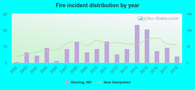 Based on the data from the years 2002 - 2018 the average number of fire incidents per year is 13. The highest number of fires - 35 took place in 2014, and the least - 1 in 2002. The data has an increasing trend.
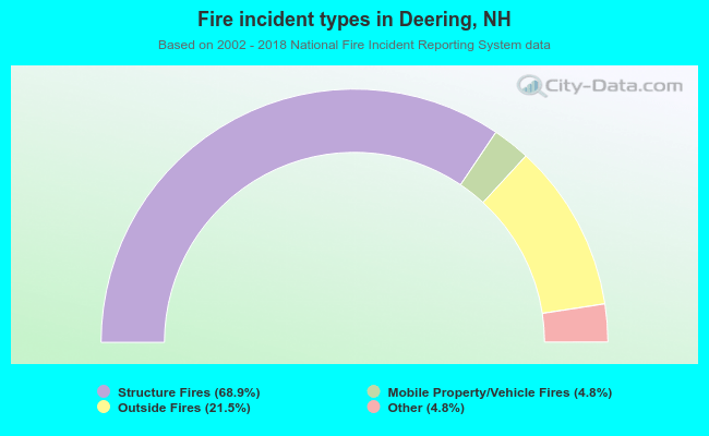 When looking into fire subcategories, the most incidents belonged to: Structure Fires (68.9%), and Outside Fires (21.5%).
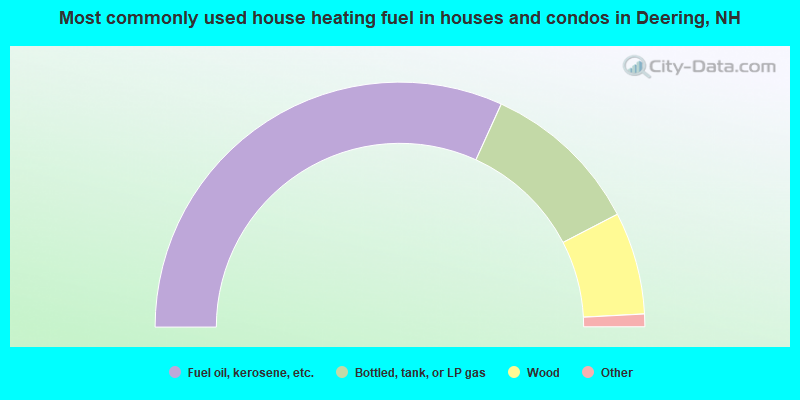
- 63.6%Fuel oil, kerosene, etc.
- 21.2%Bottled, tank, or LP gas
- 13.5%Wood
- 1.2%Utility gas
- 0.5%Coal or coke
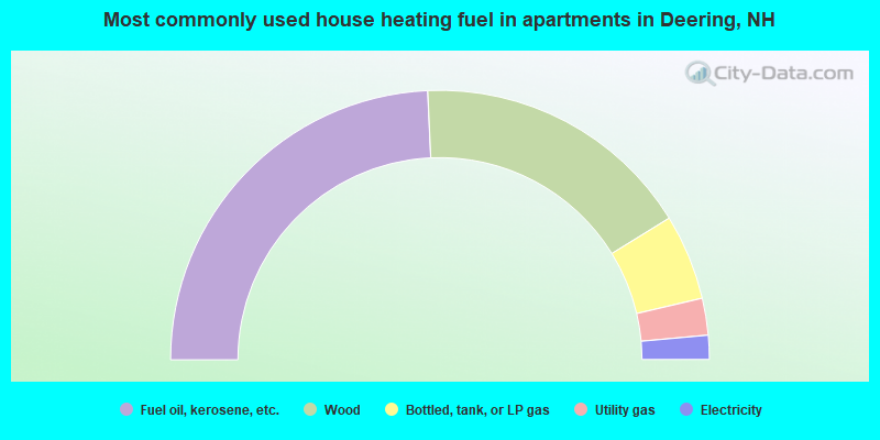
- 48.5%Fuel oil, kerosene, etc.
- 33.8%Wood
- 10.3%Bottled, tank, or LP gas
- 4.4%Utility gas
- 2.9%Electricity
Deering compared to New Hampshire state average:
- Unemployed percentage below state average.
- Black race population percentage significantly below state average.
- Hispanic race population percentage significantly below state average.
- Foreign-born population percentage significantly below state average.
- Renting percentage significantly below state average.
- Length of stay since moving in significantly above state average.
- Number of rooms per house significantly below state average.
- House age significantly below state average.
Deering on our top lists:
- #7 on the list of "Top 101 cities with the largest percentage of people in homes or halfway houses for drug/alcohol abuse (population 1,000+)"
- #27 (03244) on the list of "Top 101 zip codes with the largest percentage of Scottish first ancestries (pop 5,000+)"
- #6 on the list of "Top 101 counties with the lowest Particulate Matter (PM10) Annual air pollution readings in 2012 (µg/m3)"
- #12 on the list of "Top 101 counties with the lowest Particulate Matter (PM2.5) Annual air pollution readings in 2012 (µg/m3)"
- #15 on the list of "Top 101 counties with the lowest number of infant deaths per 1000 residents 2007-2013 (pop. 50,000+)"
- #24 on the list of "Top 101 counties with the largest decrease in the number of infant deaths per 1000 residents 2000-2006 to 2007-2013 (pop. 50,000+)"
- #44 on the list of "Top 101 counties with the lowest Nitrogen Dioxide air pollution readings in 2012 (ppm)"

|
Total of 8 patent applications in 2008-2024.