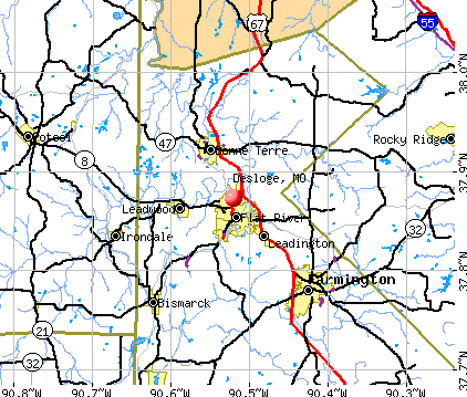
Desloge, Missouri
Submit your own pictures of this city and show them to the world
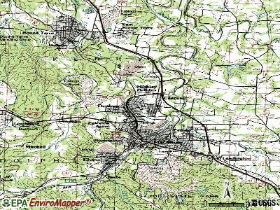
- OSM Map
- General Map
- Google Map
- MSN Map
Population change since 2000: +1.7%
 |
| Males: 2,480 | |
| Females: 2,403 |
| Median resident age: | 36.4 years |
| Missouri median age: | 39.1 years |
| Desloge: | $53,182 |
| MO: | $64,811 |
Estimated per capita income in 2022: $24,865 (it was $16,235 in 2000)
Desloge city income, earnings, and wages data
Estimated median house or condo value in 2022: $128,368 (it was $63,900 in 2000)
| Desloge: | $128,368 |
| MO: | $221,200 |
Mean prices in 2022: all housing units: $176,027; detached houses: $183,697; townhouses or other attached units: $115,615; mobile homes: $27,866
Median gross rent in 2022: $659.
Detailed information about poverty and poor residents in Desloge, MO

Compare current foreclosures near Desloge, MO:
| Photo | Address | Area | Beds / Baths | Price | Details |
|---|---|---|---|---|---|

|
#1
Dubay Dr
Cadet, MO 63630
|
2,292 sq. feet
|
2 baths 4 beds |
$419,000
|
show details |

|
#2
7th St
Farmington, MO 63640
|
- sq. feet
|
1 baths 3 beds |
$77,000
|
show details |

|
#3
N Large St
Park Hills, MO 63601
|
1,215 sq. feet
|
1 baths 2 beds |
show details | |

|
#4
E State Hwy E
Cadet, MO 63630
|
2,008 sq. feet
|
1 baths 3 beds |
show details | |

|
#5
Kingsway St
Farmington, MO 63640
|
1,038 sq. feet
|
1 baths 3 beds |
show details | |

|
#6
Taylor Ave
Park Hills, MO 63601
|
1,308 sq. feet
|
1 baths 2 beds |
show details | |

|
#7
Roberts Cir
Farmington, MO 63640
|
- sq. feet
|
2 baths 3 beds |
show details | |

|
#8
Short St
Bonne Terre, MO 63628
|
- sq. feet
|
1 baths 2 beds |
show details | |

|
#9
Lakewood Dr
De Soto, MO 63020
|
1,440 sq. feet
|
2 baths - beds |
show details | |

|
#10
Hill Side Rd
De Soto, MO 63020
|
1,590 sq. feet
|
2 baths - beds |
show details |
| Photo | Address | Area | Beds / Baths | Price | Details |
|---|---|---|---|---|---|

|
#11
Easy St
De Soto, MO 63020
|
960 sq. feet
|
- baths - beds |
show details | |

|
#12
Quints Rd
De Soto, MO 63020
|
- sq. feet
|
- baths - beds |
show details | |

|
#13
Blackwell Heights Road
Blackwell, MO 63626
|
- sq. feet
|
- baths - beds |
show details | |

|
#14
Ash St
Bonne Terre, MO 63628
|
- sq. feet
|
- baths - beds |
show details | |

|
#15
Rue Monique
Bonne Terre, MO 63628
|
- sq. feet
|
- baths - beds |
show details | |

|
#16
Cash Ln
Bonne Terre, MO 63628
|
- sq. feet
|
- baths - beds |
show details | |

|
#17
Easy St
De Soto, MO 63020
|
- sq. feet
|
- baths - beds |
show details | |

|
#18
London Rd
Farmington, MO 63640
|
- sq. feet
|
- baths - beds |
show details | |

|
#19
Mapavi Dr
Bonne Terre, MO 63628
|
- sq. feet
|
- baths - beds |
show details | |

|
#20
Ringer Rd
Bonne Terre, MO 63628
|
- sq. feet
|
- baths - beds |
show details |
| Photo | Address | Area | Beds / Baths | Price | Details |
|---|---|---|---|---|---|

|
#21
Grand Ave
Park Hills, MO 63601
|
- sq. feet
|
- baths - beds |
show details | |

|
#22
Meramec Ave
Park Hills, MO 63601
|
- sq. feet
|
- baths - beds |
show details | |

|
#23
Main St
Mineral Point, MO 63660
|
- sq. feet
|
- baths - beds |
show details | |

|
#24
Easy St
Bonne Terre, MO 63628
|
- sq. feet
|
- baths - beds |
show details | |

|
#25
Zell Cir
De Soto, MO 63020
|
- sq. feet
|
- baths - beds |
show details | |

|
#26
Cherokee, # 48
Irondale, MO 63648
|
- sq. feet
|
- baths - beds |
show details | |

|
#27
Bernice Dr
Bonne Terre, MO 63628
|
- sq. feet
|
- baths - beds |
show details | |

|
#28
Hilltop Place Dr
Farmington, MO 63640
|
- sq. feet
|
- baths - beds |
show details | |

|
#29
Pineview Rd
Mineral Point, MO 63660
|
- sq. feet
|
- baths - beds |
show details | |

|
#30
Doubet Ln
Farmington, MO 63640
|
- sq. feet
|
- baths - beds |
show details |
| Photo | Address | Area | Beds / Baths | Price | Details |
|---|---|---|---|---|---|

|
#31
Doubet Ln
Farmington, MO 63640
|
- sq. feet
|
- baths - beds |
show details | |

|
#32
Haw St Apt A
Farmington, MO 63640
|
- sq. feet
|
- baths - beds |
show details | |

|
#33
Southlake Dr
De Soto, MO 63020
|
- sq. feet
|
2 baths - beds |
show details | |

|
#34
Turley Mill Rd
Farmington, MO 63640
|
- sq. feet
|
- baths - beds |
show details | |

|
#35
Spring Hollow Rd
Valles Mines, MO 63087
|
- sq. feet
|
- baths - beds |
show details | |

|
#36
Pond Creek Rd
Mineral Point, MO 63660
|
- sq. feet
|
- baths - beds |
show details | |

|
#37
Locust Dr
Sainte Genevieve, MO 63670
|
- sq. feet
|
- baths - beds |
show details | |

|
#38
Genevieve Church Rd
Sainte Genevieve, MO 63670
|
- sq. feet
|
- baths - beds |
show details | |

|
#39
N Washington St Apt 48
Farmington, MO 63640
|
- sq. feet
|
- baths - beds |
show details | |

|
#40
Junction Rd
Cadet, MO 63630
|
- sq. feet
|
- baths - beds |
show details |
| Photo | Address | Area | Beds / Baths | Price | Details |
|---|---|---|---|---|---|

|
#41
S Henry St
Farmington, MO 63640
|
- sq. feet
|
- baths - beds |
show details | |

|
#42
Airline Dr
Farmington, MO 63640
|
- sq. feet
|
- baths - beds |
show details | |

|
#43
E 9th St
Leadwood, MO 63653
|
- sq. feet
|
- baths - beds |
show details | |

|
#44
N Saint Joe Dr Apt 3
Park Hills, MO 63601
|
- sq. feet
|
- baths - beds |
show details | |

|
#45
Falcon St Apt 62
Park Hills, MO 63601
|
- sq. feet
|
- baths - beds |
show details | |

|
#46
Falcon St Apt 10
Park Hills, MO 63601
|
- sq. feet
|
- baths - beds |
show details | |

|
#47
E Jefferson St
Potosi, MO 63664
|
- sq. feet
|
- baths - beds |
show details | |

|
#48
Pine St
Park Hills, MO 63601
|
- sq. feet
|
- baths - beds |
show details | |

|
#49
View St
Park Hills, MO 63601
|
- sq. feet
|
- baths - beds |
show details | |

|
Check over 1 million property listings on Foreclosure.com!
|
browse all offers | |||


- 4,62794.6%White alone
- 1543.1%Two or more races
- 761.6%Hispanic
- 130.3%Native Hawaiian and Other
Pacific Islander alone
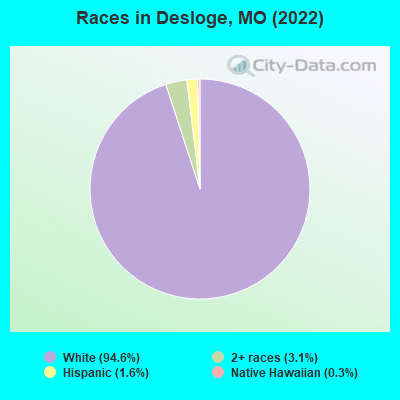
Races in Desloge detailed stats: ancestries, foreign born residents, place of birth
According to our research of Missouri and other state lists, there were 29 registered sex offenders living in Desloge, Missouri as of May 22, 2024.
The ratio of all residents to sex offenders in Desloge is 172 to 1.
Type |
2009 |
2010 |
2011 |
2012 |
2013 |
2014 |
2015 |
2016 |
2017 |
2018 |
2019 |
2020 |
2021 |
2022 |
|---|---|---|---|---|---|---|---|---|---|---|---|---|---|---|
| Murders (per 100,000) | 0 (0.0) | 0 (0.0) | 0 (0.0) | 0 (0.0) | 0 (0.0) | 0 (0.0) | 0 (0.0) | 2 (40.7) | 1 (20.4) | 1 (20.6) | 0 (0.0) | 0 (0.0) | 1 (20.5) | 0 (0.0) |
| Rapes (per 100,000) | 0 (0.0) | 1 (19.8) | 1 (19.7) | 0 (0.0) | 1 (20.2) | 1 (20.3) | 1 (20.5) | 0 (0.0) | 0 (0.0) | 0 (0.0) | 4 (82.6) | 3 (61.7) | 1 (20.5) | 10 (201.5) |
| Robberies (per 100,000) | 5 (95.6) | 1 (19.8) | 1 (19.7) | 1 (19.7) | 1 (20.2) | 1 (20.3) | 3 (61.4) | 0 (0.0) | 1 (20.4) | 1 (20.6) | 0 (0.0) | 2 (41.1) | 1 (20.5) | 3 (60.4) |
| Assaults (per 100,000) | 10 (191.3) | 10 (197.9) | 19 (374.6) | 4 (78.7) | 14 (282.3) | 11 (223.4) | 9 (184.2) | 11 (223.8) | 10 (203.7) | 13 (267.4) | 4 (82.6) | 17 (349.7) | 12 (245.8) | 7 (141.0) |
| Burglaries (per 100,000) | 15 (286.9) | 25 (494.7) | 28 (552.1) | 19 (373.9) | 31 (625.0) | 23 (467.1) | 29 (593.5) | 36 (732.3) | 23 (468.4) | 11 (226.3) | 23 (475.1) | 18 (370.3) | 8 (163.8) | 9 (181.3) |
| Thefts (per 100,000) | 231 (4,419) | 231 (4,571) | 191 (3,766) | 265 (5,214) | 279 (5,625) | 293 (5,950) | 293 (5,997) | 197 (4,007) | 248 (5,051) | 234 (4,814) | 305 (6,300) | 224 (4,608) | 92 (1,884) | 145 (2,921) |
| Auto thefts (per 100,000) | 9 (172.1) | 4 (79.1) | 7 (138.0) | 6 (118.1) | 10 (201.6) | 5 (101.5) | 9 (184.2) | 2 (40.7) | 12 (244.4) | 5 (102.9) | 16 (330.5) | 11 (226.3) | 10 (204.8) | 21 (423.0) |
| Arson (per 100,000) | 1 (19.1) | 1 (19.8) | 0 (0.0) | 0 (0.0) | 1 (20.2) | 1 (20.3) | 0 (0.0) | 4 (81.4) | 0 (0.0) | 0 (0.0) | 1 (20.7) | 0 (0.0) | 1 (20.5) | 1 (20.1) |
| City-Data.com crime index | 277.5 | 285.1 | 296.9 | 265.8 | 363.5 | 345.9 | 367.8 | 340.9 | 342.0 | 317.4 | 394.3 | 360.0 | 215.9 | 370.9 |
The City-Data.com crime index weighs serious crimes and violent crimes more heavily. Higher means more crime, U.S. average is 246.1. It adjusts for the number of visitors and daily workers commuting into cities.
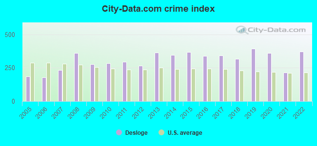
Crime rate in Desloge detailed stats: murders, rapes, robberies, assaults, burglaries, thefts, arson
Full-time law enforcement employees in 2019, including police officers: 12 (11 officers - 10 male; 1 female).
| Officers per 1,000 residents here: | 2.27 |
| Missouri average: | 2.48 |
 Recent articles from our blog. Our writers, many of them Ph.D. graduates or candidates, create easy-to-read articles on a wide variety of topics.


 | Missouri Outlaw History (3407 replies) |
| Interesting Missouri facts. (1186 replies) |
| Tallest buildings in Missouri (17 replies) |
| Uneducated people & Drugs (161 replies) |
| Missouri...Southern or Midwestern? (1475 replies) |
| Moving out of STL... Need your help finding a place! (4 replies) |
Latest news from Desloge, MO collected exclusively by city-data.com from local newspapers, TV, and radio stations
Ancestries: American (61.5%), English (8.7%), Irish (8.1%), German (5.6%), Italian (4.2%), Scottish (1.4%).
Current Local Time: CST time zone
Incorporated in 1941
Elevation: 805 feet
Land area: 2.65 square miles.
Population density: 1,839 people per square mile (low).
34 residents are foreign born
| This city: | 0.7% |
| Missouri: | 2.7% |
Median real estate property taxes paid for housing units with mortgages in 2022: $1,439 (1.0%)
Median real estate property taxes paid for housing units with no mortgage in 2022: $1,258 (1.2%)
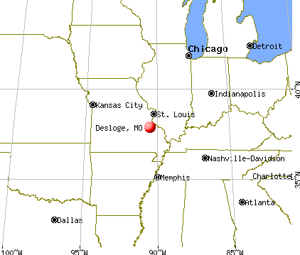
Nearest city with pop. 50,000+: St. Louis, MO  (54.4 miles , pop. 348,189).
Nearest city with pop. 1,000,000+: Chicago, IL (313.1 miles , pop. 2,896,016).
Nearest cities:
), ), ), ), Latitude: 37.87 N, Longitude: 90.52 W
Area code commonly used in this area: 573
Desloge, Missouri accommodation & food services, waste management - Economy and Business Data
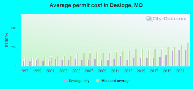
Single-family new house construction building permits:
- 2022: 5 buildings, average cost: $215,000
- 2021: 8 buildings, average cost: $217,500
- 2020: 9 buildings, average cost: $199,100
- 2019: 6 buildings, average cost: $148,800
- 2018: 3 buildings, average cost: $123,300
- 2017: 6 buildings, average cost: $107,800
- 2016: 6 buildings, average cost: $107,800
- 2015: 1 building, cost: $110,000
- 2014: 2 buildings, average cost: $107,500
- 2013: 1 building, cost: $85,000
- 2012: 1 building, cost: $139,200
- 2011: 3 buildings, average cost: $94,800
- 2010: 8 buildings, average cost: $88,300
- 2009: 7 buildings, average cost: $80,000
- 2008: 6 buildings, average cost: $94,500
- 2007: 15 buildings, average cost: $82,100
- 2006: 18 buildings, average cost: $86,300
- 2005: 20 buildings, average cost: $92,500
- 2004: 18 buildings, average cost: $86,800
- 2003: 18 buildings, average cost: $87,400
- 2002: 8 buildings, average cost: $93,000
- 2001: 8 buildings, average cost: $76,400
- 2000: 7 buildings, average cost: $77,100
- 1999: 18 buildings, average cost: $87,900
- 1998: 29 buildings, average cost: $73,800
- 1997: 21 buildings, average cost: $73,700
| Here: | 3.6% |
| Missouri: | 2.8% |
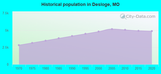
Population change in the 1990s: +791 (+19.7%).
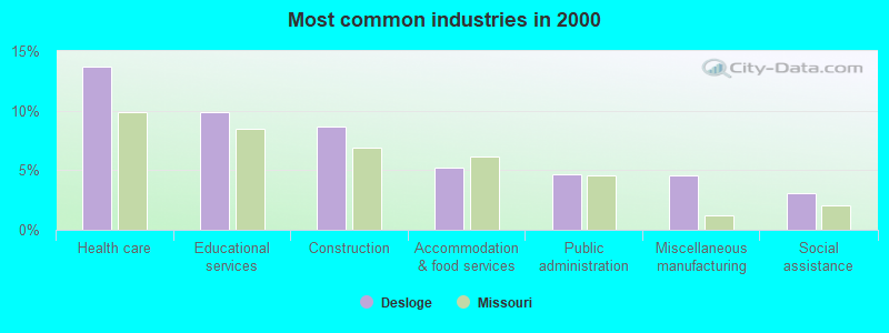
- Health care (13.7%)
- Educational services (9.9%)
- Construction (8.7%)
- Accommodation & food services (5.2%)
- Public administration (4.7%)
- Miscellaneous manufacturing (4.6%)
- Social assistance (3.1%)
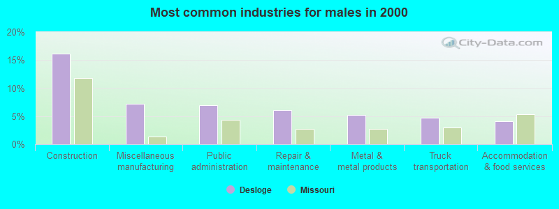
- Construction (16.2%)
- Miscellaneous manufacturing (7.3%)
- Public administration (7.0%)
- Repair & maintenance (6.1%)
- Metal & metal products (5.3%)
- Truck transportation (4.7%)
- Accommodation & food services (4.0%)
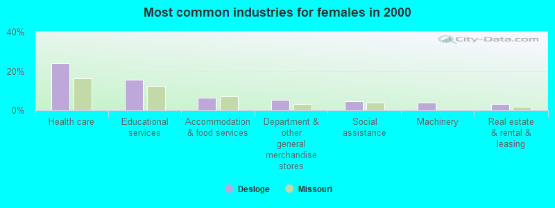
- Health care (24.2%)
- Educational services (15.6%)
- Accommodation & food services (6.4%)
- Department & other general merchandise stores (5.4%)
- Social assistance (4.5%)
- Machinery (4.0%)
- Real estate & rental & leasing (3.3%)
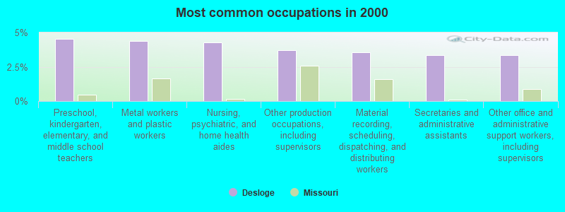
- Preschool, kindergarten, elementary, and middle school teachers (4.6%)
- Metal workers and plastic workers (4.4%)
- Nursing, psychiatric, and home health aides (4.3%)
- Other production occupations, including supervisors (3.7%)
- Material recording, scheduling, dispatching, and distributing workers (3.6%)
- Secretaries and administrative assistants (3.4%)
- Other office and administrative support workers, including supervisors (3.4%)
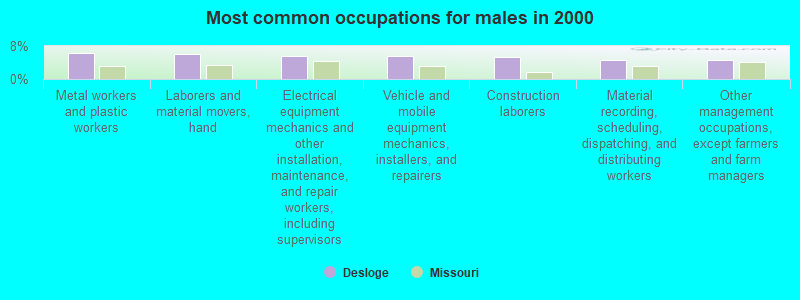
- Metal workers and plastic workers (6.2%)
- Laborers and material movers, hand (6.1%)
- Electrical equipment mechanics and other installation, maintenance, and repair workers, including supervisors (5.6%)
- Vehicle and mobile equipment mechanics, installers, and repairers (5.6%)
- Construction laborers (5.4%)
- Material recording, scheduling, dispatching, and distributing workers (4.6%)
- Other management occupations, except farmers and farm managers (4.6%)
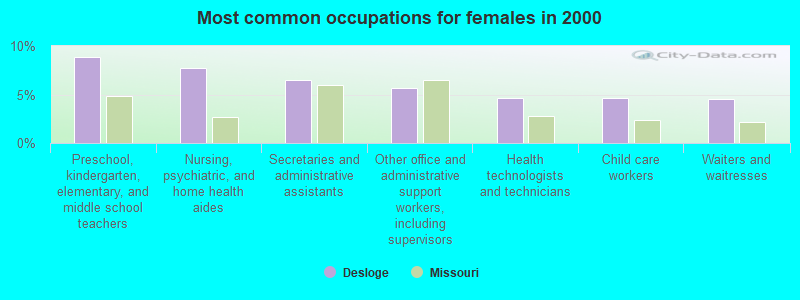
- Preschool, kindergarten, elementary, and middle school teachers (8.8%)
- Nursing, psychiatric, and home health aides (7.7%)
- Secretaries and administrative assistants (6.5%)
- Other office and administrative support workers, including supervisors (5.7%)
- Health technologists and technicians (4.7%)
- Child care workers (4.6%)
- Waiters and waitresses (4.5%)
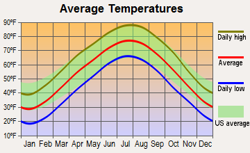
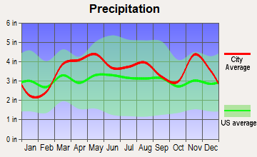
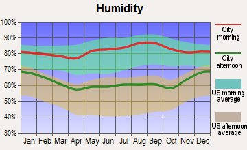
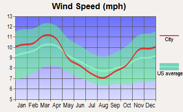
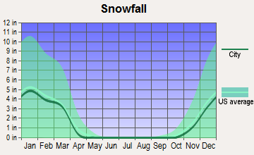
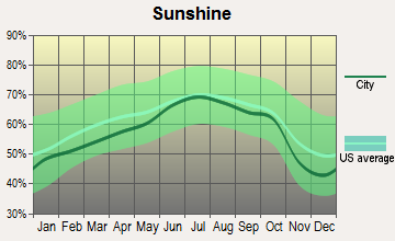
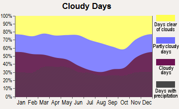
Average climate in Desloge, Missouri
Based on data reported by over 4,000 weather stations
(lower is better)
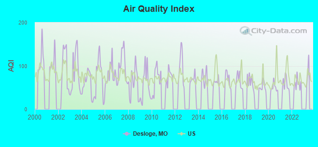
Air Quality Index (AQI) level in 2022 was 58.8. This is better than average.
| City: | 58.8 |
| U.S.: | 72.6 |
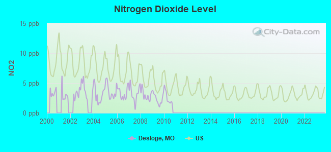
Nitrogen Dioxide (NO2) [ppb] level in 2010 was 2.53. This is significantly better than average. Closest monitor was 5.6 miles away from the city center.
| City: | 2.53 |
| U.S.: | 5.11 |
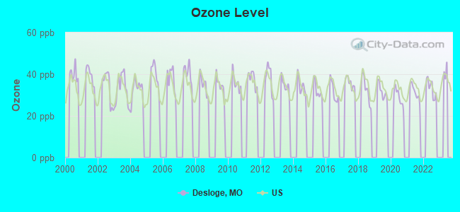
Ozone [ppb] level in 2022 was 33.4. This is about average. Closest monitor was 5.6 miles away from the city center.
| City: | 33.4 |
| U.S.: | 33.3 |
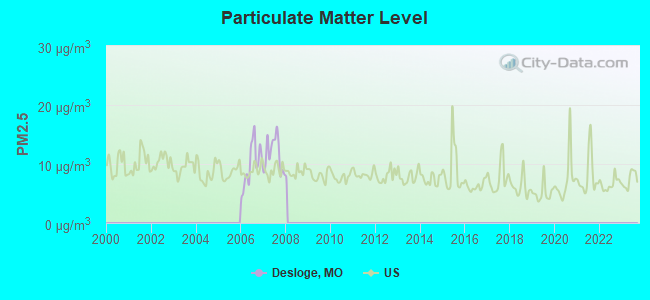
Particulate Matter (PM2.5) [µg/m3] level in 2007 was 11.7. This is significantly worse than average. There were 0 monitors within city limits.
| City: | 11.7 |
| U.S.: | 8.1 |
Tornado activity:
Desloge-area historical tornado activity is near Missouri state average. It is 68% greater than the overall U.S. average.
On 6/22/1969, a category F4 (max. wind speeds 207-260 mph) tornado 10.0 miles away from the Desloge city center killed 4 people and injured 14 people and caused between $500,000 and $5,000,000 in damages.
On 12/21/1967, a category F4 tornado 13.6 miles away from the city center killed 3 people and injured 52 people and caused between $500,000 and $5,000,000 in damages.
Earthquake activity:
Desloge-area historical earthquake activity is significantly above Missouri state average. It is 376% greater than the overall U.S. average.On 4/18/2008 at 09:36:59, a magnitude 5.4 (5.1 MB, 4.8 MS, 5.4 MW, 5.2 MW, Class: Moderate, Intensity: VI - VII) earthquake occurred 148.8 miles away from Desloge center
On 9/26/1990 at 13:18:51, a magnitude 5.0 (4.7 MB, 4.8 LG, 5.0 LG, Depth: 7.7 mi) earthquake occurred 72.8 miles away from Desloge center
On 5/4/1991 at 01:18:54, a magnitude 5.0 (4.4 MB, 4.6 LG, 5.0 LG, Depth: 3.1 mi) earthquake occurred 98.3 miles away from Desloge center
On 4/18/2008 at 09:36:59, a magnitude 5.2 (5.2 MW, Depth: 8.9 mi) earthquake occurred 148.7 miles away from the city center
On 6/10/1987 at 23:48:54, a magnitude 5.1 (4.9 MB, 4.4 MS, 4.6 MS, 5.1 LG) earthquake occurred 157.3 miles away from Desloge center
On 6/18/2002 at 17:37:15, a magnitude 5.0 (4.3 MB, 4.6 MW, 5.0 LG) earthquake occurred 149.7 miles away from Desloge center
Magnitude types: regional Lg-wave magnitude (LG), body-wave magnitude (MB), surface-wave magnitude (MS), moment magnitude (MW)
Natural disasters:
The number of natural disasters in St. Francois County (3) is a lot smaller than the US average (15).Major Disasters (Presidential) Declared: 1
Emergencies Declared: 1
Causes of natural disasters: Floods: 2, Storms: 2, Tornadoes: 2, Winds: 2, Other: 1 (Note: some incidents may be assigned to more than one category).
Hospitals and medical centers in Desloge:
Other hospitals and medical centers near Desloge:
- COUNTRY MEADOWS (Nursing Home, about 2 miles away; PARK HILLS, MO)
- PARKLAND HOME CARE (Home Health Center, about 3 miles away; PARK HILLS, MO)
- BONNE TERRE HOSPITAL (Hospital, about 4 miles away; BONNE TERRE, MO)
- ST JOE MANOR (Nursing Home, about 4 miles away; BONNE TERRE, MO)
- CAMELOT NURSING CENTER (Nursing Home, about 6 miles away; FARMINGTON, MO)
- MARMC HOME HEALTH SERVICES (Home Health Center, about 7 miles away; FARMINGTON, MO)
- MINERAL AREA REGIONAL MEDICAL CENTER Acute Care Hospitals (about 7 miles away; FARMINGTON, MO)
Colleges/universities with over 2000 students nearest to Desloge:
- Mineral Area College (about 3 miles; Park Hills, MO; Full-time enrollment: 2,837)
- Jefferson College (about 27 miles; Hillsboro, MO; FT enrollment: 3,975)
- East Central College (about 46 miles; Union, MO; FT enrollment: 2,810)
- Webster University (about 51 miles; Saint Louis, MO; FT enrollment: 12,406)
- Missouri Baptist University (about 54 miles; Saint Louis, MO; FT enrollment: 2,898)
- Maryville University of Saint Louis (about 54 miles; Saint Louis, MO; FT enrollment: 3,651)
- Washington University in St Louis (about 55 miles; Saint Louis, MO; FT enrollment: 10,823)
Public elementary/middle schools in Desloge:
- INTERMEDIATE SCH. (Students: 467, Location: 801 ELM ST, Grades: 5-6)
- NORTH CO. MIDDLE (Students: 466, Location: 406 E CHESTNUT, Grades: 7-8)
- NORTH COUNTY PARKSIDE ELEM. (Location: 100 N PARKSIDE, Grades: 3-4)
Points of interest:
Notable location: Desloge Volunteer Fire Department (A). Display/hide its location on the map
Creek: Koen Creek (A). Display/hide its location on the map
Hotels: Budget Inn (404 North State Street), Econo Lodge (402 N State St).
Birthplace of: Sam Fox - Diplomat, Bobby Tiefenauer - Baseball player.
Drinking water stations with addresses in Desloge and their reported violations in the past:
DESLOGE (Population served: 5,000, Groundwater):Past monitoring violations:
- Lead Consumer Notice - In JAN-01-2011, Contaminant: Lead and Copper Rule. Follow-up actions: St Compliance achieved (JUN-10-2014)
| This city: | 2.4 people |
| Missouri: | 2.5 people |
| This city: | 65.1% |
| Whole state: | 65.3% |
| This city: | 8.3% |
| Whole state: | 6.7% |
Likely homosexual households (counted as self-reported same-sex unmarried-partner households)
- Lesbian couples: 0.3% of all households
- Gay men: 0.3% of all households
83 people in nursing homes in 2000
Banks with branches in Desloge (2011 data):
- Belgrade State Bank: Desloge at 414 North State Street, branch established on 1997/03/19. Info updated 2006/11/03: Bank assets: $194.8 mil, Deposits: $171.8 mil, headquarters in Belgrade, MO, positive income, Commercial Lending Specialization, 6 total offices, Holding Company: Turner Bancshares, Inc.
- UNICO Bank: Desloge Branch at 400 North State Street, branch established on 2008/11/13. Info updated 2010/08/16: Bank assets: $229.8 mil, Deposits: $201.8 mil, headquarters in Mineral Point, MO, positive income, 11 total offices, Holding Company: Washco Bancshares, Inc.
- Bank Star of the LeadBelt: Desloge Branch at 1135 North Desloge Drive, branch established on 1996/05/23. Info updated 2006/11/03: Bank assets: $112.4 mil, Deposits: $98.7 mil, headquarters in Park Hills, MO, positive income, Commercial Lending Specialization, 6 total offices, Holding Company: Bancstar, Inc.
- Commerce Bank: Desloge Branch at 1101 N. Desloge Dr, branch established on 1977/10/17. Info updated 2011/07/07: Bank assets: $20,493.6 mil, Deposits: $16,805.3 mil, headquarters in Kansas City, MO, positive income, 206 total offices, Holding Company: Commerce Bancshares, Inc.
For population 15 years and over in Desloge:
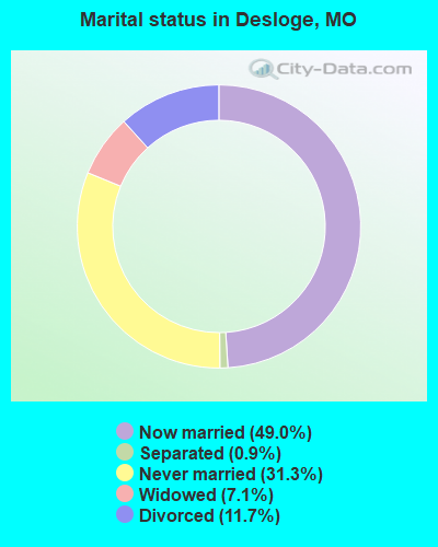
- Never married: 31.3%
- Now married: 49.0%
- Separated: 0.9%
- Widowed: 7.1%
- Divorced: 11.7%
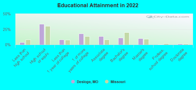
For population 25 years and over in Desloge:
- High school or higher: 95.5%
- Bachelor's degree or higher: 18.3%
- Graduate or professional degree: 9.7%
- Unemployed: 5.4%
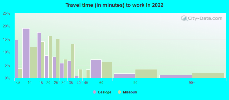
- Mean travel time to work (commute): 13.2 minutes
| Here: | 9.3 |
| Missouri average: | 11.1 |
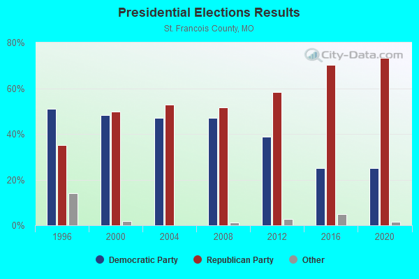
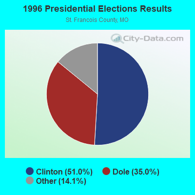
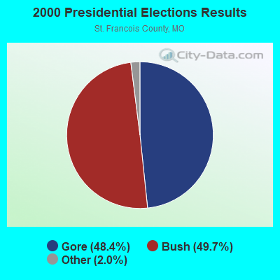

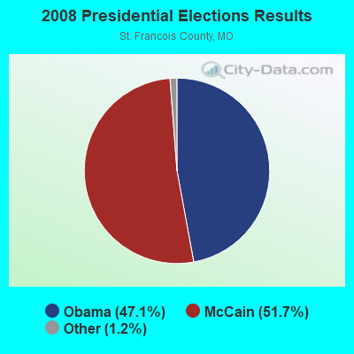
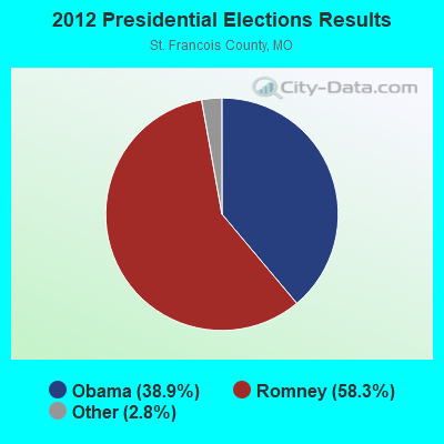

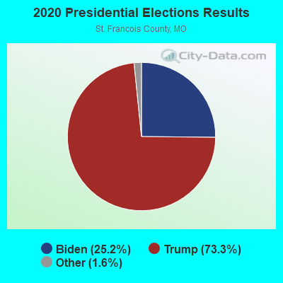
Graphs represent county-level data. Detailed 2008 Election Results
Religion statistics for Desloge, MO (based on St. Francois County data)
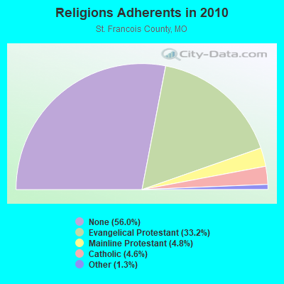
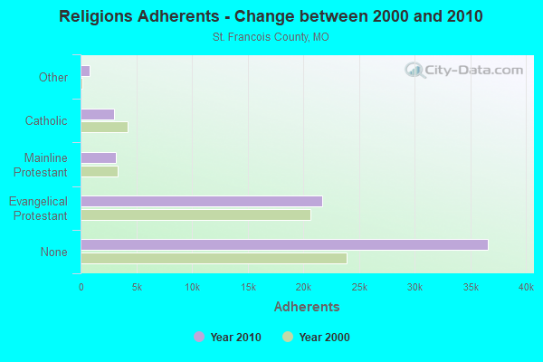
| Religion | Adherents | Congregations |
|---|---|---|
| Evangelical Protestant | 21,697 | 96 |
| Mainline Protestant | 3,156 | 18 |
| Catholic | 2,991 | 5 |
| Other | 853 | 6 |
| Orthodox | 40 | 1 |
| None | 36,622 | - |
Food Environment Statistics:
| St. Francois County: | 1.75 / 10,000 pop. |
| Missouri: | 1.88 / 10,000 pop. |
| Here: | 0.16 / 10,000 pop. |
| State: | 0.18 / 10,000 pop. |
| Here: | 0.96 / 10,000 pop. |
| Missouri: | 0.60 / 10,000 pop. |
| Here: | 5.42 / 10,000 pop. |
| Missouri: | 4.34 / 10,000 pop. |
| Here: | 6.05 / 10,000 pop. |
| Missouri: | 7.37 / 10,000 pop. |
| St. Francois County: | 8.6% |
| Missouri: | 8.8% |
| St. Francois County: | 30.4% |
| State: | 29.6% |
| Here: | 16.0% |
| Missouri: | 13.5% |
Health and Nutrition:
| This city: | 49.2% |
| Missouri: | 50.9% |
| This city: | 48.2% |
| Missouri: | 48.6% |
| Desloge: | 28.1 |
| State: | 28.7 |
| This city: | 15.9% |
| Missouri: | 20.6% |
| Desloge: | 11.0% |
| Missouri: | 10.1% |
| This city: | 6.8 |
| Missouri: | 6.8 |
| Desloge: | 37.5% |
| Missouri: | 34.3% |
| Desloge: | 50.4% |
| Missouri: | 57.5% |
| Here: | 79.5% |
| State: | 79.3% |
More about Health and Nutrition of Desloge, MO Residents
| Local government employment and payroll (March 2022) | |||||
| Function | Full-time employees | Monthly full-time payroll | Average yearly full-time wage | Part-time employees | Monthly part-time payroll |
|---|---|---|---|---|---|
| Police Protection - Officers | 12 | $42,913 | $42,913 | 0 | $0 |
| Streets and Highways | 6 | $20,606 | $41,212 | 1 | $977 |
| Water Supply | 6 | $21,186 | $42,372 | 0 | $0 |
| Financial Administration | 4 | $12,334 | $37,002 | 0 | $0 |
| Parks and Recreation | 3 | $9,127 | $36,508 | 0 | $0 |
| Solid Waste Management | 2 | $5,235 | $31,410 | 0 | $0 |
| Judicial and Legal | 2 | $4,513 | $27,078 | 0 | $0 |
| Other and Unallocable | 1 | $3,406 | $40,872 | 2 | $443 |
| Other Government Administration | 1 | $5,961 | $71,532 | 0 | $0 |
| Police - Other | 1 | $2,104 | $25,248 | 0 | $0 |
| Local Libraries | 0 | $0 | 2 | $2,604 | |
| Totals for Government | 38 | $127,383 | $40,226 | 5 | $4,023 |
Desloge government finances - Expenditure in 2017 (per resident):
- Current Operations - Police Protection: $636,000 ($130.25)
Financial Administration: $479,000 ($98.10)
Regular Highways: $445,000 ($91.13)
Water Utilities: $297,000 ($60.82)
Solid Waste Management: $259,000 ($53.04)
Parks and Recreation: $187,000 ($38.30)
Judicial and Legal Services: $115,000 ($23.55)
Libraries: $63,000 ($12.90)
Local Fire Protection: $62,000 ($12.70)
Protective Inspection and Regulation - Other: $55,000 ($11.26)
- Other Capital Outlay - Regular Highways: $95,000 ($19.46)
Parks and Recreation: $80,000 ($16.38)
Local Fire Protection: $65,000 ($13.31)
Police Protection: $53,000 ($10.85)
Financial Administration: $49,000 ($10.03)
Judicial and Legal Services: $2,000 ($0.41)
- Total Salaries and Wages: $1,542,000 ($315.79)
Desloge government finances - Revenue in 2017 (per resident):
- Charges - Parks and Recreation: $44,000 ($9.01)
- Miscellaneous - Fines and Forfeits: $205,000 ($41.98)
General Revenue - Other: $62,000 ($12.70)
Interest Earnings: $26,000 ($5.32)
Sale of Property: $23,000 ($4.71)
Donations From Private Sources: $1,000 ($0.20)
Rents: $1,000 ($0.20)
- Revenue - Water Utilities: $628,000 ($128.61)
- State Intergovernmental - Highways: $44,000 ($9.01)
- Tax - General Sales and Gross Receipts: $2,282,000 ($467.34)
Public Utilities Sales: $386,000 ($79.05)
Property: $152,000 ($31.13)
Occupation and Business License - Other: $8,000 ($1.64)
Alcoholic Beverage License: $2,000 ($0.41)
Desloge government finances - Debt in 2017 (per resident):
- Long Term Debt - Beginning Outstanding - Unspecified Public Purpose: $6,790,000 ($1390.54)
Beginning Outstanding - Public Debt for Private Purpose: $6,790,000 ($1390.54)
Outstanding Unspecified Public Purpose: $6,440,000 ($1318.86)
Outstanding Nonguaranteed - Industrial Revenue: $6,440,000 ($1318.86)
Retired Unspecified Public Purpose: $350,000 ($71.68)
Retired Nonguaranteed - Public Debt for Private Purpose: $350,000 ($71.68)
Desloge government finances - Cash and Securities in 2017 (per resident):
- Other Funds - Cash and Securities: $2,564,000 ($525.09)
- Sinking Funds - Cash and Securities: $6,440,000 ($1318.86)
| Businesses in Desloge, MO | ||||
| Name | Count | Name | Count | |
|---|---|---|---|---|
| 7-Eleven | 1 | McDonald's | 1 | |
| AT&T | 1 | Pizza Hut | 1 | |
| AutoZone | 1 | SONIC Drive-In | 1 | |
| Blockbuster | 1 | T-Mobile | 1 | |
| Burger King | 1 | Taco Bell | 1 | |
| FedEx | 1 | U.S. Cellular | 1 | |
| H&R Block | 1 | UPS | 1 | |
| Jack In The Box | 1 | Walmart | 1 | |
| Little Caesars Pizza | 1 | |||
Strongest AM radio stations in Desloge:
- KFMO (1240 AM; 1 kW; FLAT RIVER, MO; Owner: M. K. S. BROADCASTING, INC.)
- KREI (800 AM; 1 kW; FARMINGTON, MO; Owner: KREI, INC.)
- KXEN (1010 AM; 50 kW; FESTUS-ST. LOUIS, MO; Owner: BDJ RADIO ENTERPRISES, LLC)
- KMOX (1120 AM; 50 kW; ST. LOUIS, MO; Owner: INFINITY BROADCASTING OPERATIONS, INC.)
- WSDZ (1260 AM; 20 kW; BELLEVILLE, IL)
- KTRS (550 AM; 5 kW; ST. LOUIS, MO; Owner: KTRS-AM LICENSE, L.L.C.)
- KRFT (1190 AM; 10 kW; DE SOTO, MO; Owner: ALL SPORTS RADIO, LLC)
- KJSL (630 AM; 5 kW; ST. LOUIS, MO; Owner: WMUZ RADIO, INC.)
- KFUO (850 AM; 5 kW; CLAYTON, MO; Owner: LUTHERAN CHURCH-MISSOURI SYNOD)
- WCRV (640 AM; 50 kW; COLLIERVILLE, TN; Owner: BOTT BROADCASTING COMPANY/TENNESSEE)
- KYRO (1280 AM; 0 kW; POTOSI, MO; Owner: SAVOY BROADCASTING CO.)
- KSLG (1380 AM; 5 kW; ST. LOUIS, MO; Owner: NEW HORIZON 7TH-DAY CHRISTIAN CHURCH, INC.)
- WDDD (810 AM; 10 kW; JOHNSTON CITY, IL; Owner: CLEAR CHANNEL BROADCASTING LICENSES, INC.)
Strongest FM radio stations in Desloge:
- KDBB (104.3 FM; BONNE TERRE, MO; Owner: MKS BROADCASTING, INC.)
- KBGM (91.1 FM; PARK HILLS, MO; Owner: AMERICAN FAMILY ASSOCIATION)
- KTJJ (98.5 FM; FARMINGTON, MO; Owner: KREI, INC.)
- KHZR (97.7 FM; POTOSI, MO; Owner: FOUR HIM ENTERPRISES, L.L.C.)
- KPNT (105.7 FM; ST. GENEVIEVE, MO; Owner: EMMIS RADIO LICENSE CORPORATION)
- KDJR (100.1 FM; DE SOTO, MO; Owner: KDJR RADIO, INC.)
- KYLS-FM (95.9 FM; IRONTON, MO; Owner: DOCKINS COMMUNICATIONS, INC.)
- KNSX (93.3 FM; STEELVILLE, MO; Owner: TWENTY-ONE SOUND COMMUNICATIONS, INC)
- KNLP (89.7 FM; POTOSI, MO; Owner: NEW LIFE EVANGELISTIC CENTER, INC.)
- WIL-FM (92.3 FM; ST. LOUIS, MO; Owner: BONNEVILLE HOLDING COMPANY)
- KNLH (89.5 FM; CEDAR HILL, MO; Owner: NEW LIFE EVANGELISTIC CENTER, INC.)
- KTBJ (89.3 FM; FESTUS, MO; Owner: CSN INTERNATIONAL)
- KDHX (88.1 FM; ST. LOUIS, MO; Owner: DOUBLE HELIX CORPORATION)
- KBDZ (93.1 FM; PERRYVILLE, MO; Owner: D/B/A DONZE COMMUNICATIONS, INC.)
TV broadcast stations around Desloge:
- KNLC (Channel 24; ST. LOUIS, MO; Owner: NEW LIFE EVANGELISTIC CENTER, INC.)
- KETC (Channel 9; ST. LOUIS, MO; Owner: ST. LOUIS REGIONAL & EDUCATIONAL PUBLIC TV COMMISSION)
- WRBU (Channel 46; EAST ST. LOUIS, IL; Owner: ROBERTS BROADCASTING COMPANY)
- KMOV (Channel 4; ST. LOUIS, MO; Owner: KMOV-TV, INC.)
- National Bridge Inventory (NBI) Statistics
- 10Number of bridges
- 253ft / 77.1mTotal length
- $1,713,000Total costs
- 70,453Total average daily traffic
- 6,779Total average daily truck traffic
- 119,226Total future (year 2041) average daily traffic
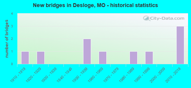
- New bridges - historical statistics
- 11910-1919
- 11920-1929
- 21950-1959
- 11960-1969
- 11980-1989
- 11990-1999
- 32010-2019
FCC Registered Broadcast Land Mobile Towers:
4- 209 N Desloge Dr (Lat: 37.369500 Lon: -90.526500), Call Sign: KNFL985,
Assigned Frequencies: 155.925 MHz, Grant Date: 06/09/2022, Expiration Date: 06/11/2032, Registrant: Business Radio Licensing, 30251 Golden Lantern, Suite E # 501, Laguna Niguel, CA 92677, Phone: (949) 348-8510, Fax: (949) 348-8514, Email:
- 1208 N Main St (Lat: 37.870833 Lon: -90.527222), Call Sign: WPVN605,
Assigned Frequencies: 468.762 MHz, 468.837 MHz, 469.137 MHz, 469.462 MHz, 469.637 MHz, 469.662 MHz, 469.887 MHz, 457.512 MHz, 457.537 MHz, 457.562 MHz, 457.587 MHz, 457.612 MHz, Grant Date: 07/22/2002, Expiration Date: 07/22/2012, Cancellation Date: 09/22/2012, Certifier: Sheryl Kirkpatrick, Registrant: Hm Electronics, Inc., 6675 Mesa Ridge Rd, San Diego, CA 92121, Phone: (858) 535-6015, Fax: (858) 452-6707, Email:
- 1208 N Main Street (Lat: 37.842778 Lon: -90.496917), Call Sign: WQBK246,
Assigned Frequencies: 154.540 MHz, 33.1600 MHz, 35.0200 MHz, 31.2400 MHz, 30.8400 MHz, 33.1600 MHz, 154.515 MHz, 151.835 MHz, 457.612 MHz, 457.587 MHz... (+11 more), Grant Date: 10/22/2004, Expiration Date: 10/22/2014, Cancellation Date: 12/27/2014, Certifier: Dave Demario, Registrant: Hm Electronics, Inc., 14110 Stowe Drive, Poway, CA 92064, Phone: (858) 535-6015, Fax: (858) 452-6707, Email:
- Hawthorne Rd. (Lat: 37.891389 Lon: -90.523944), Type: Bant, Structure height: 4.5 m, Overall height: 5.4 m, Call Sign: WQGM902,
Assigned Frequencies: 153.725 MHz, Grant Date: 12/20/2016, Expiration Date: 03/06/2027, Certifier: Eric Wiederhold, Registrant: City Of Desloge, 300 North Lincoln Street, Desloge, MO 63601, Phone: (573) 431-3700, Fax: (573) 431-7062, Email:
FCC Registered Amateur Radio Licenses:
12 (See the full list of FCC Registered Amateur Radio Licenses in Desloge)2002 - 2018 National Fire Incident Reporting System (NFIRS) incidents
- Fire incident types reported to NFIRS in Desloge, MO
- 29461.4%Structure Fires
- 12526.1%Outside Fires
- 326.7%Mobile Property/Vehicle Fires
- 285.8%Other
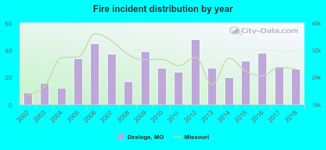 According to the data from the years 2002 - 2018 the average number of fires per year is 28. The highest number of reported fire incidents - 48 took place in 2012, and the least - 9 in 2002. The data has a rising trend.
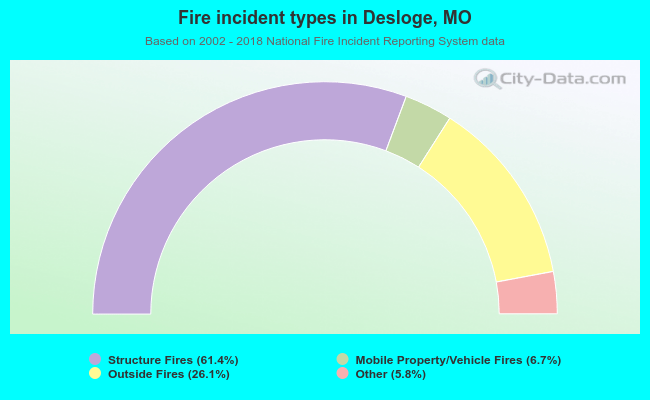 When looking into fire subcategories, the most incidents belonged to: Structure Fires (61.4%), and Outside Fires (26.1%).
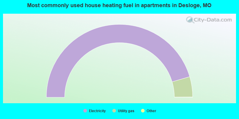
- 66.3%Electricity
- 32.4%Utility gas
- 1.3%Solar energy
- 91.0%Electricity
- 9.0%Utility gas
Desloge compared to Missouri state average:
- Median house value below state average.
- Unemployed percentage below state average.
- Black race population percentage significantly below state average.
- Hispanic race population percentage significantly below state average.
- Foreign-born population percentage significantly below state average.
- Number of college students below state average.

|
Total of 1 patent application in 2008-2024.