Dexter, Missouri
Submit your own pictures of this city and show them to the world
- OSM Map
- General Map
- Google Map
- MSN Map

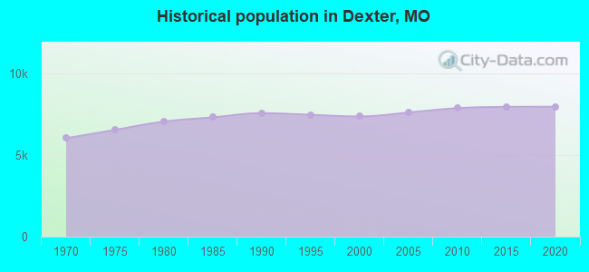
Population change since 2000: +6.9%
 |
| Males: 3,552 | |
| Females: 4,314 |
| Median resident age: | 39.1 years |
| Missouri median age: | 39.1 years |
Zip codes: 63841.
| Dexter: | $44,850 |
| MO: | $64,811 |
Estimated per capita income in 2022: $23,565 (it was $15,034 in 2000)
Dexter city income, earnings, and wages data
Estimated median house or condo value in 2022: $138,666 (it was $57,300 in 2000)
| Dexter: | $138,666 |
| MO: | $221,200 |
Mean prices in 2022: all housing units: $169,618; detached houses: $174,833; townhouses or other attached units: $159,794; mobile homes: $114,045; occupied boats, rvs, vans, etc.: $50,685
Median gross rent in 2022: $672.
(21.9% for White Non-Hispanic residents, 55.4% for Black residents, 23.3% for Hispanic or Latino residents, 21.0% for American Indian residents, 6.0% for two or more races residents)
Detailed information about poverty and poor residents in Dexter, MO

Compare current foreclosures near Dexter, MO:
| Photo | Address | Area | Beds / Baths | Price | Details |
|---|---|---|---|---|---|

|
#1
Glenstone Rd
Dexter, MO 63841
|
- sq. feet
|
1 baths 3 beds |
show details | |

|
#2
N Poplar St
Dexter, MO 63841
|
- sq. feet
|
1 baths 3 beds |
show details | |

|
#3
N Walnut St
Dexter, MO 63841
|
1,250 sq. feet
|
- baths - beds |
show details | |

|
#4
N Sassafrass St
Dexter, MO 63841
|
- sq. feet
|
- baths - beds |
show details | |

|
#5
Mcnair St
Dexter, MO 63841
|
- sq. feet
|
- baths - beds |
show details | |

|
#6
N Hickory St
Dexter, MO 63841
|
- sq. feet
|
- baths - beds |
show details | |

|
#7
Cabin Ln
Dexter, MO 63841
|
- sq. feet
|
- baths - beds |
show details | |

|
#8
E Taylor St
Dexter, MO 63841
|
- sq. feet
|
- baths - beds |
show details | |

|
#9
E Stanley St
Dexter, MO 63841
|
- sq. feet
|
- baths - beds |
show details | |

|
#10
E Castor St
Dexter, MO 63841
|
- sq. feet
|
- baths - beds |
show details |
| Photo | Address | Area | Beds / Baths | Price | Details |
|---|---|---|---|---|---|

|
#11
State Highway Af
Dexter, MO 63841
|
- sq. feet
|
- baths - beds |
show details | |

|
#12
E Oak St
Dexter, MO 63841
|
- sq. feet
|
- baths - beds |
show details | |

|
#13
W Elk St
Dexter, MO 63841
|
- sq. feet
|
- baths - beds |
show details | |

|
#14
Thrower St
Dexter, MO 63841
|
- sq. feet
|
- baths - beds |
show details | |

|
#15
County Road 648
Dexter, MO 63841
|
- sq. feet
|
- baths - beds |
show details | |

|
#16
Colonial Ridge Dr
Dexter, MO 63841
|
- sq. feet
|
- baths - beds |
show details | |

|
#17
Kent Blvd
Malden, MO 63863
|
1,872 sq. feet
|
- baths - beds |
$37,900
|
show details |

|
#18
N Madison St
Malden, MO 63863
|
- sq. feet
|
1 baths 3 beds |
show details | |

|
#19
W Main Ave
Bernie, MO 63822
|
1,070 sq. feet
|
1 baths 3 beds |
show details | |

|
#20
County Road 644
Fisk, MO 63940
|
1,116 sq. feet
|
1 baths 3 beds |
show details |
| Photo | Address | Area | Beds / Baths | Price | Details |
|---|---|---|---|---|---|

|
#21
Dayton St
Bernie, MO 63822
|
1,008 sq. feet
|
- baths - beds |
show details | |

|
#22
Newcomer St
Bloomfield, MO 63825
|
- sq. feet
|
- baths - beds |
$64,900
|
show details |

|
#23
W Sue Dr
Malden, MO 63863
|
1,459 sq. feet
|
- baths - beds |
show details | |

|
#24
Fleming St
Bernie, MO 63822
|
- sq. feet
|
- baths - beds |
show details | |

|
#25
East St
Sikeston, MO 63801
|
1,295 sq. feet
|
- baths - beds |
show details | |

|
#26
S Edwards St
Malden, MO 63863
|
- sq. feet
|
- baths - beds |
show details | |

|
#27
Ken Ln
Campbell, MO 63933
|
- sq. feet
|
- baths - beds |
show details | |

|
#28
Maple Ln
Bloomfield, MO 63825
|
- sq. feet
|
- baths - beds |
show details | |

|
#29
Tom St
Malden, MO 63863
|
1,404 sq. feet
|
- baths - beds |
show details | |

|
#30
Fairview Ln
Puxico, MO 63960
|
- sq. feet
|
- baths - beds |
show details |
| Photo | Address | Area | Beds / Baths | Price | Details |
|---|---|---|---|---|---|

|
#31
N Bedford St
Puxico, MO 63960
|
- sq. feet
|
- baths - beds |
show details | |

|
#32
N Buena Vista St
Puxico, MO 63960
|
- sq. feet
|
- baths - beds |
show details | |

|
#33
Hard Acre Ln
Campbell, MO 63933
|
1,976 sq. feet
|
- baths - beds |
show details | |

|
#34
County Road 518
Bell City, MO 63735
|
- sq. feet
|
- baths - beds |
show details | |

|
#35
E Hobgood Ave
Bernie, MO 63822
|
- sq. feet
|
- baths - beds |
show details | |

|
#36
Lockwood Ct
Bloomfield, MO 63825
|
- sq. feet
|
- baths - beds |
show details | |

|
#37
County Road 307
Advance, MO 63730
|
- sq. feet
|
- baths - beds |
show details | |

|
#38
Fleming St
Bernie, MO 63822
|
- sq. feet
|
- baths - beds |
show details | |

|
Check over 1 million property listings on Foreclosure.com!
|
browse all offers | |||


- 7,36992.8%White alone
- 2292.9%Hispanic
- 1842.3%Two or more races
- 961.2%Black alone
- 120.2%American Indian alone
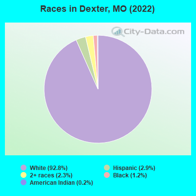
Races in Dexter detailed stats: ancestries, foreign born residents, place of birth
According to our research of Missouri and other state lists, there were 56 registered sex offenders living in Dexter, Missouri as of May 01, 2024.
The ratio of all residents to sex offenders in Dexter is 142 to 1.
Type |
2009 |
2010 |
2011 |
2012 |
2013 |
2014 |
2015 |
2016 |
2017 |
2018 |
2019 |
2020 |
2021 |
2022 |
|---|---|---|---|---|---|---|---|---|---|---|---|---|---|---|
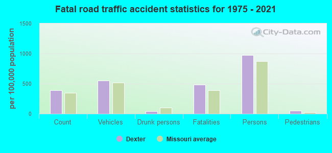
| Murders (per 100,000) | 0 (0.0) | 0 (0.0) | 0 (0.0) | 0 (0.0) | 0 (0.0) | 0 (0.0) | 0 (0.0) | 0 (0.0) | 0 (0.0) | 1 (12.8) | 0 (0.0) | 0 (0.0) | 1 (12.8) | 0 (0.0) |
| Rapes (per 100,000) | 0 (0.0) | 1 (12.7) | 1 (12.7) | 1 (12.8) | 1 (12.7) | 0 (0.0) | 0 (0.0) | 0 (0.0) | 0 (0.0) | 1 (12.8) | 7 (89.0) | 9 (115.3) | 11 (140.4) | 2 (25.5) |
| Robberies (per 100,000) | 0 (0.0) | 1 (12.7) | 0 (0.0) | 4 (51.0) | 3 (38.1) | 0 (0.0) | 0 (0.0) | 1 (12.5) | 1 (12.6) | 1 (12.8) | 1 (12.7) | 2 (25.6) | 1 (12.8) | 1 (12.7) |
| Assaults (per 100,000) | 18 (234.6) | 10 (127.2) | 6 (76.0) | 20 (255.2) | 16 (203.0) | 8 (100.6) | 13 (162.7) | 9 (112.3) | 9 (113.4) | 2 (25.5) | 7 (89.0) | 26 (333.0) | 20 (255.3) | 13 (165.5) |
| Burglaries (per 100,000) | 53 (690.6) | 70 (890.1) | 52 (658.8) | 59 (752.7) | 40 (507.5) | 41 (515.5) | 29 (362.9) | 47 (586.5) | 28 (352.9) | 61 (778.2) | 42 (534.3) | 45 (576.4) | 25 (319.2) | 25 (318.3) |
| Thefts (per 100,000) | 200 (2,606) | 239 (3,039) | 217 (2,749) | 246 (3,139) | 255 (3,235) | 210 (2,641) | 197 (2,465) | 188 (2,346) | 121 (1,525) | 146 (1,862) | 146 (1,857) | 172 (2,203) | 156 (1,992) | 125 (1,592) |
| Auto thefts (per 100,000) | 8 (104.2) | 11 (139.9) | 13 (164.7) | 13 (165.9) | 8 (101.5) | 11 (138.3) | 6 (75.1) | 3 (37.4) | 5 (63.0) | 8 (102.1) | 5 (63.6) | 16 (204.9) | 13 (166.0) | 16 (203.7) |
| Arson (per 100,000) | 0 (0.0) | 1 (12.7) | 1 (12.7) | 1 (12.8) | 0 (0.0) | 0 (0.0) | 0 (0.0) | 3 (37.4) | 2 (25.2) | 0 (0.0) | 0 (0.0) | 2 (25.6) | 2 (25.5) | 0 (0.0) |
| City-Data.com crime index | 207.8 | 234.5 | 194.6 | 268.1 | 235.2 | 172.9 | 162.5 | 164.1 | 117.2 | 181.8 | 209.6 | 311.4 | 308.1 | 159.5 |
The City-Data.com crime index weighs serious crimes and violent crimes more heavily. Higher means more crime, U.S. average is 246.1. It adjusts for the number of visitors and daily workers commuting into cities.
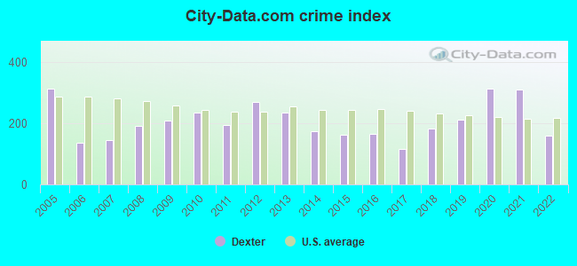
Crime rate in Dexter detailed stats: murders, rapes, robberies, assaults, burglaries, thefts, arson
Full-time law enforcement employees in 2021, including police officers: 25 (18 officers - 18 male; 0 female).
| Officers per 1,000 residents here: | 2.30 |
| Missouri average: | 2.54 |
 Recent articles from our blog. Our writers, many of them Ph.D. graduates or candidates, create easy-to-read articles on a wide variety of topics.

 | Is the ‘Midwesternness’ of Northern Missouri overstated? (99 replies) |
| Does Missouri have any of the magic of the Southern States? (72 replies) |
| Is St. Louis a Southern city? (755 replies) |
| Interesting Missouri facts. (1186 replies) |
| New Madrid grumpy today (4 replies) |
| Missouri Outlaw History (3407 replies) |
Latest news from Dexter, MO collected exclusively by city-data.com from local newspapers, TV, and radio stations
Ancestries: American (26.6%), German (18.9%), Irish (13.6%), English (8.6%), European (2.4%), French (1.5%).
Current Local Time: CST time zone
Incorporated in 1873
Elevation: 368 feet
Land area: 6.09 square miles.
Population density: 1,292 people per square mile (low).
100 residents are foreign born
| This city: | 1.4% |
| Missouri: | 2.7% |
Median real estate property taxes paid for housing units with mortgages in 2022: $1,039 (0.7%)
Median real estate property taxes paid for housing units with no mortgage in 2022: $1,238 (1.1%)
Nearest city with pop. 50,000+: Jonesboro, AR  (78.4 miles , pop. 55,515).
Nearest city with pop. 200,000+: Memphis, TN (116.2 miles , pop. 650,100).
Nearest city with pop. 1,000,000+: Chicago, IL (369.6 miles , pop. 2,896,016).
Nearest cities:
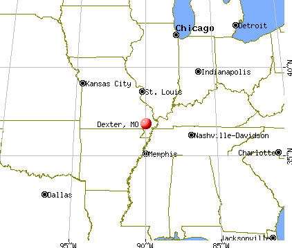
), ), )Latitude: 36.80 N, Longitude: 89.96 W
Daytime population change due to commuting: +1,869 (+23.5%)
Workers who live and work in this city: 1,562 (49.9%)
Area code: 573

Dexter, Missouri accommodation & food services, waste management - Economy and Business Data
Single-family new house construction building permits:
- 2022: 4 buildings, average cost: $306,300
- 2021: 6 buildings, average cost: $223,000
- 2020: 2 buildings, average cost: $67,500
- 2019: 13 buildings, average cost: $122,700
- 2018: 10 buildings, average cost: $118,500
- 2017: 7 buildings, average cost: $137,100
- 2016: 12 buildings, average cost: $88,200
- 2015: 13 buildings, average cost: $157,800
- 2014: 12 buildings, average cost: $193,400
- 2013: 9 buildings, average cost: $103,300
- 2012: 9 buildings, average cost: $90,800
- 2011: 4 buildings, average cost: $62,500
- 2010: 7 buildings, average cost: $87,000
- 2009: 11 buildings, average cost: $176,300
- 2008: 21 buildings, average cost: $70,300
- 2007: 15 buildings, average cost: $100,100
- 2006: 34 buildings, average cost: $122,000
- 2005: 49 buildings, average cost: $111,300
- 2004: 16 buildings, average cost: $139,100
- 2003: 24 buildings, average cost: $90,000
- 2002: 31 buildings, average cost: $71,900
- 2001: 20 buildings, average cost: $111,900
- 2000: 27 buildings, average cost: $71,400
- 1999: 31 buildings, average cost: $108,900
- 1998: 23 buildings, average cost: $88,200
- 1997: 16 buildings, average cost: $84,800
| Here: | 4.4% |
| Missouri: | 2.8% |
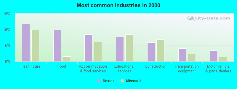
- Health care (11.8%)
- Food (9.9%)
- Accommodation & food services (8.5%)
- Educational services (7.7%)
- Construction (6.0%)
- Transportation equipment (4.1%)
- Motor vehicle & parts dealers (3.5%)
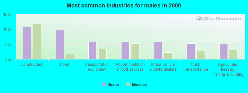
- Construction (10.8%)
- Food (9.7%)
- Transportation equipment (6.0%)
- Accommodation & food services (5.9%)
- Motor vehicle & parts dealers (5.8%)
- Truck transportation (5.3%)
- Agriculture, forestry, fishing & hunting (5.1%)
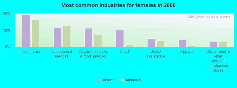
- Health care (19.1%)
- Educational services (11.6%)
- Accommodation & food services (11.1%)
- Food (10.2%)
- Social assistance (4.9%)
- Apparel (4.2%)
- Department & other general merchandise stores (3.1%)
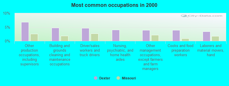
- Other production occupations, including supervisors (6.8%)
- Building and grounds cleaning and maintenance occupations (4.7%)
- Driver/sales workers and truck drivers (4.7%)
- Nursing, psychiatric, and home health aides (4.0%)
- Other management occupations, except farmers and farm managers (3.9%)
- Cooks and food preparation workers (3.9%)
- Laborers and material movers, hand (3.4%)
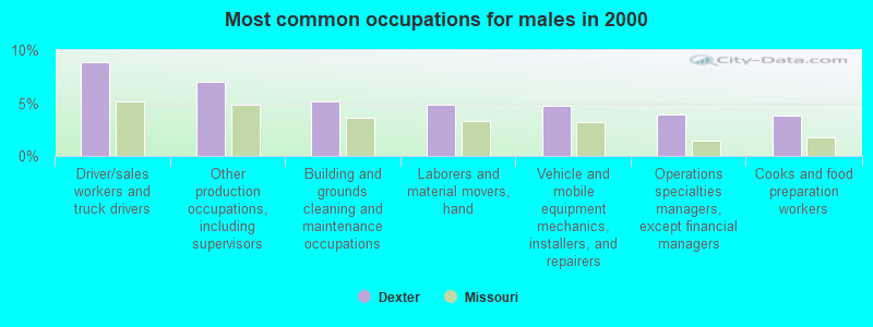
- Driver/sales workers and truck drivers (8.9%)
- Other production occupations, including supervisors (7.0%)
- Building and grounds cleaning and maintenance occupations (5.2%)
- Laborers and material movers, hand (4.8%)
- Vehicle and mobile equipment mechanics, installers, and repairers (4.7%)
- Operations specialties managers, except financial managers (3.9%)
- Cooks and food preparation workers (3.8%)
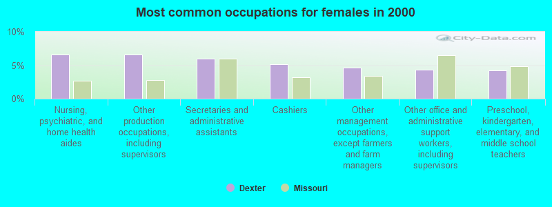
- Nursing, psychiatric, and home health aides (6.6%)
- Other production occupations, including supervisors (6.6%)
- Secretaries and administrative assistants (6.0%)
- Cashiers (5.1%)
- Other management occupations, except farmers and farm managers (4.6%)
- Other office and administrative support workers, including supervisors (4.4%)
- Preschool, kindergarten, elementary, and middle school teachers (4.2%)
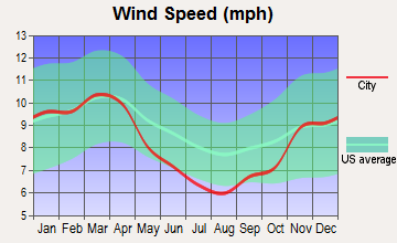
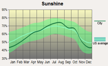
Average climate in Dexter, Missouri
Based on data reported by over 4,000 weather stations


|
|


Tornado activity:
Dexter-area historical tornado activity is slightly above Missouri state average. It is 81% greater than the overall U.S. average.
On 4/24/2002, a category F4 (max. wind speeds 207-260 mph) tornado 20.4 miles away from the Dexter city center injured 16 people and caused $45 million in damages.
On 4/22/1981, a category F4 tornado 28.8 miles away from the city center killed one person and injured 32 people and caused between $5,000,000 and $50,000,000 in damages.
Earthquake activity:
Dexter-area historical earthquake activity is significantly above Missouri state average. It is 413% greater than the overall U.S. average.On 5/4/1991 at 01:18:54, a magnitude 5.0 (4.4 MB, 4.6 LG, 5.0 LG, Depth: 3.1 mi, Class: Moderate, Intensity: VI - VII) earthquake occurred 17.9 miles away from Dexter center
On 9/26/1990 at 13:18:51, a magnitude 5.0 (4.7 MB, 4.8 LG, 5.0 LG, Depth: 7.7 mi) earthquake occurred 34.8 miles away from Dexter center
On 4/18/2008 at 09:36:59, a magnitude 5.4 (5.1 MB, 4.8 MS, 5.4 MW, 5.2 MW) earthquake occurred 161.4 miles away from Dexter center
On 3/25/1976 at 00:41:20, a magnitude 5.0 (4.9 MB, 5.0 LG) earthquake occurred 82.7 miles away from the city center
On 4/18/2008 at 09:36:59, a magnitude 5.2 (5.2 MW, Depth: 8.9 mi) earthquake occurred 161.4 miles away from the city center
On 4/27/1989 at 16:47:49, a magnitude 4.7 (4.6 MB, 4.7 LG, 4.3 LG, Class: Light, Intensity: IV - V) earthquake occurred 55.7 miles away from Dexter center
Magnitude types: regional Lg-wave magnitude (LG), body-wave magnitude (MB), surface-wave magnitude (MS), moment magnitude (MW)
Natural disasters:
The number of natural disasters in Stoddard County (22) is greater than the US average (15).Major Disasters (Presidential) Declared: 15
Emergencies Declared: 5
Causes of natural disasters: Floods: 15, Storms: 13, Tornadoes: 13, Winter Storms: 5, Winds: 4, Heavy Rain: 1, Hurricane: 1, Other: 1 (Note: some incidents may be assigned to more than one category).
Hospitals in Dexter:
- DEXTER MEMORIAL HOSPICE (1200 N ONE MILE ROAD)
- PREFERRED HOSPICE OF MISSOURI (423 BUSINESS HIGHWAY 60 WEST BOX 99)
- SOUTHEASTHEALTH CENTER OF STODDARD COUNTY (Proprietary, 1200 N ONE MILE RD)
Nursing Homes in Dexter:
- CROWLEY RIDGE CARE CENTER (1204 NORTH OUTER ROAD, PO BOX 668)
- CYPRESS POINT-SKILLED NURSING BY AMERICARE (801 BAILIFF DRIVE)
- DEXTER NURSING CENTER (P O BOX 517)
- GOLDEN LIVINGCENTER-DEXTER (415 S CATALPA STREET)
- VINTAGE VILLA (228 E MARKET ST)
Dialysis Facilities in Dexter:
Home Health Centers in Dexter:
Airports and heliports located in Dexter:
- Dexter Municipal Airport (DXE) (Runways: 1, Air Taxi Ops: 660, Itinerant Ops: 2,860, Local Ops: 1,650, Military Ops: 40)
- Southeast Health Center Of Stoddard County Heliport (68MO)
Colleges/universities with over 2000 students nearest to Dexter:
- Three Rivers Community College (about 26 miles; Poplar Bluff, MO; Full-time enrollment: 3,360)
- Southeast Missouri State University (about 44 miles; Cape Girardeau, MO; FT enrollment: 9,678)
- Dyersburg State Community College (about 61 miles; Dyersburg, TN; FT enrollment: 2,211)
- The University of Tennessee-Martin (about 69 miles; Martin, TN; FT enrollment: 7,013)
- West Kentucky Community and Technical College (about 75 miles; Paducah, KY; FT enrollment: 4,107)
- Southern Illinois University-Carbondale (about 76 miles; Carbondale, IL; FT enrollment: 14,539)
- Arkansas State University-Main Campus (about 78 miles; Jonesboro, AR; FT enrollment: 12,323)
Public high schools in Dexter:
- DEXTER HIGH (Students: 609, Location: 1101 W GRANT ST, Grades: 9-12)
- CROWLEY RIDGE SCHOOL (Location: 910 NINA ST, Grades: KG-12)
Public elementary/middle schools in Dexter:
- SOUTHWEST ELEM. (Students: 556, Location: 915 W GRANT ST, Grades: PK-2)
- CENTRAL ELEM. (Students: 463, Location: 1213 CENTRAL DR, Grades: 3-5)
- T. S. HILL MIDDLE (Students: 441, Location: 1107 BROWN PILOT LN, Grades: 6-8)
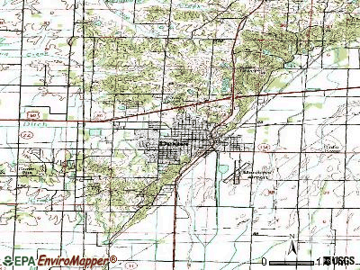
Points of interest:
Notable locations in Dexter: Dexter Junction (A), Dexter Fire Department Station 2 (B), Dexter Fire Department Station 3 (C). Display/hide their locations on the map
Cemeteries: Dexter Cemetery (1), Miller Cemetery (2). Display/hide their locations on the map
Creek: Dexter Creek (A). Display/hide its location on the map
Park in Dexter: East Park (1). Display/hide its location on the map
Tourist attraction: Bootheel Buggies (Tours & Charters; 1021 Scott Avenue).
Hotels: Dexter Inn (Business Route 60), Country Hearth Inn - Dexter (913 Outer Rd), Oak Tree Inn (1608 West Business USHighway).
Courts: Missouri State - Conservation Dept- Otter Slough CA (7001 County Road 675), Crossroad Court Sc (1309 West Business USHighway), Dexter-City - Municipal Court (134 South Elm Street).
Birthplace of: David Lee (American football coach) - Football coach, George K. Sisler - Army Medal of Honor recipient, Brett Hale - College basketball player (SE Missouri State Indians), Clarence Paul Oliver - Biologist, Max West - Baseball player, Remond Willis - Football player.
Drinking water stations with addresses in Dexter that have no violations reported:
- DEXTER (Population served: 8,000, Primary Water Source Type: Groundwater)
- HWY 60 RV PARK (Population served: 25, Primary Water Source Type: Groundwater)
| This city: | 2.3 people |
| Missouri: | 2.5 people |
| This city: | 62.8% |
| Whole state: | 65.3% |
| This city: | 6.7% |
| Whole state: | 6.7% |
Likely homosexual households (counted as self-reported same-sex unmarried-partner households)
- Lesbian couples: 0.3% of all households
- Gay men: 0.1% of all households
12 people in group homes intended for adults in 2010
People in group quarters in Dexter in 2000:
- 102 people in nursing homes
- 41 people in other noninstitutional group quarters
- 8 people in homes for the mentally retarded
Banks with most branches in Dexter (2011 data):
- First Midwest Bank of Dexter: First Midwest Bank Of Dexter at 20 West Stoddard Street, branch established on 1964/01/15; Dexter Branch at 819 Bus 60 West, branch established on 1979/12/10. Info updated 2006/11/03: Bank assets: $249.5 mil, Deposits: $223.1 mil, local headquarters, positive income, Commercial Lending Specialization, 5 total offices, Holding Company: Midwest Bancorporation, Inc. And Affiliates Esop Trust
- Regions Bank: Dexter Mo at 1028 Highway 60 West, branch established on 1996/03/25. Info updated 2011/02/24: Bank assets: $123,368.2 mil, Deposits: $98,301.3 mil, headquarters in Birmingham, AL, positive income, Commercial Lending Specialization, 1778 total offices, Holding Company: Regions Financial Corporation
- First National Bank: Dexter Branch at 310 North Walnut, branch established on 1998/08/17. Info updated 2006/11/03: Bank assets: $186.0 mil, Deposits: $167.5 mil, headquarters in Malden, MO, positive income, Agricultural Specialization, 4 total offices, Holding Company: First Malden Bancshares, Inc.
- First Commercial Bank: Dexter Branch at 303 Market Street, branch established on 1998/10/26. Info updated 2006/11/03: Bank assets: $223.9 mil, Deposits: $176.7 mil, headquarters in Gideon, MO, positive income, Commercial Lending Specialization, 9 total offices, Holding Company: Gideon Bancshares Company
- Montgomery Bank, National Association: Dexter Branch at 140 South Walnut, branch established on 2007/05/21. Info updated 2010/06/03: Bank assets: $881.2 mil, Deposits: $723.4 mil, headquarters in Sikeston, MO, positive income, Commercial Lending Specialization, 12 total offices, Holding Company: Montgomery Bancorporation, Inc.
- Southern Bank: Business 60 W Branch at 713 Business 60 West, branch established on 1887/01/01. Info updated 2010/12/20: Bank assets: $773.3 mil, Deposits: $630.2 mil, headquarters in Poplar Bluff, MO, positive income, Commercial Lending Specialization, 19 total offices, Holding Company: Southern Missouri Bancorp, Inc.
- The Bank of Advance: Dexter Branch at 1428 Business Highway 60 West, branch established on 1999/02/01. Info updated 2006/11/03: Bank assets: $262.4 mil, Deposits: $217.2 mil, headquarters in Advance, MO, positive income, Agricultural Specialization, 6 total offices, Holding Company: Miles Bancshares, Inc.
- U.S. Bank National Association: Dexter Branch at 1603 W Business Us Highway 60, branch established on 1984/04/02. Info updated 2012/01/30: Bank assets: $330,470.8 mil, Deposits: $236,091.5 mil, headquarters in Cincinnati, OH, positive income, 3121 total offices, Holding Company: U.S. Bancorp
- First State Bank and Trust Company, Inc.: Dexter Branch at 710 West Business 60, branch established on 2003/08/01. Info updated 2011/04/12: Bank assets: $361.3 mil, Deposits: $319.4 mil, headquarters in Caruthersville, MO, positive income, Agricultural Specialization, 5 total offices, Holding Company: First State Bancorp, Inc.
For population 15 years and over in Dexter:
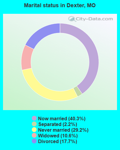
- Never married: 29.2%
- Now married: 40.3%
- Separated: 2.2%
- Widowed: 10.6%
- Divorced: 17.7%
For population 25 years and over in Dexter:
- High school or higher: 82.5%
- Bachelor's degree or higher: 13.0%
- Graduate or professional degree: 4.6%
- Unemployed: 7.8%
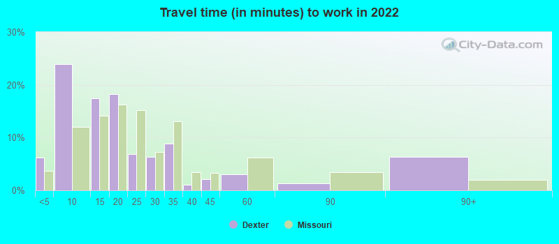
- Mean travel time to work (commute): 16.8 minutes
| Here: | 11.4 |
| Missouri average: | 11.1 |
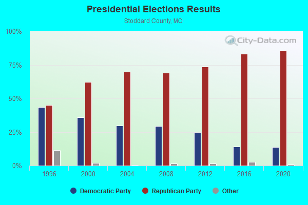
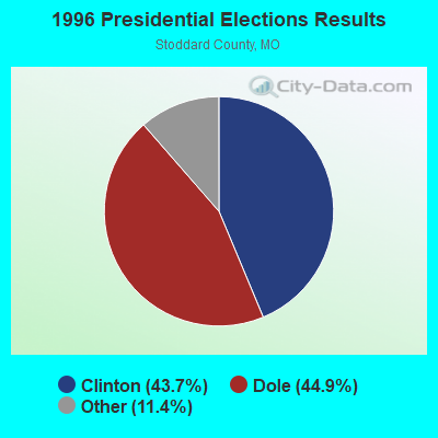
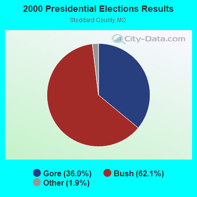

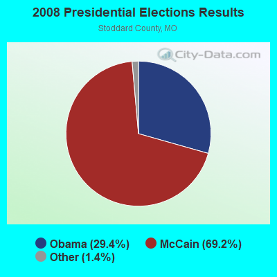
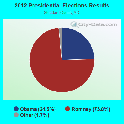


Graphs represent county-level data. Detailed 2008 Election Results
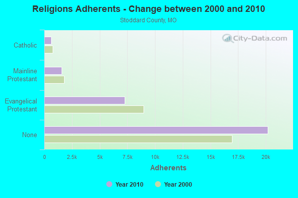
Religion statistics for Dexter, MO (based on Stoddard County data)
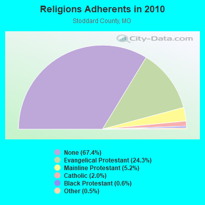
| Religion | Adherents | Congregations |
|---|---|---|
| Evangelical Protestant | 7,276 | 54 |
| Mainline Protestant | 1,568 | 9 |
| Catholic | 610 | 2 |
| Black Protestant | 181 | 1 |
| Other | 136 | 3 |
| None | 20,197 | - |
Food Environment Statistics:
| Stoddard County: | 2.02 / 10,000 pop. |
| Missouri: | 1.88 / 10,000 pop. |
| Stoddard County: | 2.36 / 10,000 pop. |
| Missouri: | 0.60 / 10,000 pop. |
| This county: | 6.74 / 10,000 pop. |
| Missouri: | 4.34 / 10,000 pop. |
| Stoddard County: | 6.74 / 10,000 pop. |
| State: | 7.37 / 10,000 pop. |
| This county: | 9.2% |
| Missouri: | 8.8% |
| Stoddard County: | 28.5% |
| Missouri: | 29.6% |
| Stoddard County: | 16.8% |
| Missouri: | 13.5% |
Health and Nutrition:
| Dexter: | 49.5% |
| Missouri: | 50.9% |
| This city: | 45.2% |
| State: | 48.6% |
| Here: | 29.3 |
| Missouri: | 28.7 |
| Here: | 21.0% |
| Missouri: | 20.6% |
| This city: | 14.0% |
| Missouri: | 10.1% |
| This city: | 6.9 |
| Missouri: | 6.8 |
| Here: | 35.2% |
| Missouri: | 34.3% |
| Dexter: | 55.3% |
| State: | 57.5% |
| This city: | 75.9% |
| Missouri: | 79.3% |
More about Health and Nutrition of Dexter, MO Residents
| Local government employment and payroll (March 2022) | |||||
| Function | Full-time employees | Monthly full-time payroll | Average yearly full-time wage | Part-time employees | Monthly part-time payroll |
|---|---|---|---|---|---|
| Other and Unallocable | 0 | $0 | 0 | $0 | |
| Totals for Government | 0 | $0 | 0 | $0 | |
Dexter government finances - Expenditure in 2021 (per resident):
- Construction - Sewerage: $1,856,000 ($235.95)
Regular Highways: $527,000 ($67.00)
Water Utilities: $73,000 ($9.28)
Electric Utilities: $72,000 ($9.15)
Parks and Recreation: $33,000 ($4.20)
Air Transportation: $30,000 ($3.81)
- Current Operations - Electric Utilities: $8,462,000 ($1075.77)
Parks and Recreation: $1,163,000 ($147.85)
Police Protection: $1,057,000 ($134.38)
Water Utilities: $920,000 ($116.96)
Sewerage: $769,000 ($97.76)
General - Other: $758,000 ($96.36)
Local Fire Protection: $448,000 ($56.95)
Financial Administration: $437,000 ($55.56)
Central Staff Services: $437,000 ($55.56)
Regular Highways: $383,000 ($48.69)
General Public Buildings: $248,000 ($31.53)
Libraries: $177,000 ($22.50)
Air Transportation: $140,000 ($17.80)
Protective Inspection and Regulation - Other: $136,000 ($17.29)
Judicial and Legal Services: $50,000 ($6.36)
- General - Interest on Debt: $29,000 ($3.69)
- Other Capital Outlay - Local Fire Protection: $178,000 ($22.63)
Regular Highways: $94,000 ($11.95)
Police Protection: $61,000 ($7.75)
Parks and Recreation: $53,000 ($6.74)
Water Utilities: $27,000 ($3.43)
Libraries: $10,000 ($1.27)
General Public Building: $7,000 ($0.89)
- Total Salaries and Wages: $2,705,000 ($343.89)
- Water Utilities - Interest on Debt: $5,000 ($0.64)
Dexter government finances - Revenue in 2021 (per resident):
- Charges - Sewerage: $1,412,000 ($179.51)
Parks and Recreation: $701,000 ($89.12)
Other: $596,000 ($75.77)
Air Transportation: $104,000 ($13.22)
- Local Intergovernmental - Other: $386,000 ($49.07)
- Miscellaneous - Interest Earnings: $107,000 ($13.60)
Fines and Forfeits: $93,000 ($11.82)
General Revenue - Other: $59,000 ($7.50)
Donations From Private Sources: $58,000 ($7.37)
Sale of Property: $31,000 ($3.94)
Rents: $3,000 ($0.38)
- Revenue - Electric Utilities: $9,130,000 ($1160.69)
Water Utilities: $1,385,000 ($176.07)
- State Intergovernmental - Highways: $345,000 ($43.86)
Housing and Community Development: $148,000 ($18.82)
Public Welfare: $132,000 ($16.78)
Other: $120,000 ($15.26)
- Tax - General Sales and Gross Receipts: $3,715,000 ($472.29)
Property: $400,000 ($50.85)
Public Utilities Sales: $205,000 ($26.06)
Other Selective Sales: $127,000 ($16.15)
Occupation and Business License - Other: $60,000 ($7.63)
Other License: $51,000 ($6.48)
Dexter government finances - Debt in 2021 (per resident):
- Long Term Debt - Beginning Outstanding - Unspecified Public Purpose: $501,000 ($63.69)
Outstanding Unspecified Public Purpose: $268,000 ($34.07)
Retired Unspecified Public Purpose: $233,000 ($29.62)
Dexter government finances - Cash and Securities in 2021 (per resident):
- Other Funds - Cash and Securities: $7,059,000 ($897.41)
- Sinking Funds - Cash and Securities: $2,241,000 ($284.90)
| Businesses in Dexter, MO | ||||
| Name | Count | Name | Count | |
|---|---|---|---|---|
| AT&T | 1 | MasterBrand Cabinets | 2 | |
| AutoZone | 1 | McDonald's | 1 | |
| Burger King | 1 | Nissan | 1 | |
| Chevrolet | 1 | Pizza Hut | 1 | |
| Curves | 1 | RadioShack | 1 | |
| Econo Lodge | 1 | SONIC Drive-In | 1 | |
| FedEx | 1 | Subway | 1 | |
| Ford | 1 | Taco Bell | 1 | |
| H&R Block | 1 | U-Haul | 2 | |
| Jones New York | 1 | UPS | 1 | |
| KFC | 1 | Walmart | 1 | |
Strongest AM radio stations in Dexter:
- KDEX (1590 AM; daytime; 1 kW; DEXTER, MO; Owner: DEXTER BROADCASTING COMPANY)
- KWOC (930 AM; 5 kW; POPLAR BLUFF, MO; Owner: ZIMMER RADIO OF MID-MISSOURI, INC)
- KRHW (1520 AM; 5 kW; SIKESTON, MO)
- KOTC (830 AM; daytime; 10 kW; KENNETT, MO; Owner: EAGLE BLUFF ENTERPRISES)
- WCRV (640 AM; 50 kW; COLLIERVILLE, TN; Owner: BOTT BROADCASTING COMPANY/TENNESSEE)
- WDIA (1070 AM; 50 kW; MEMPHIS, TN; Owner: CLEAR CHANNEL BROADCASTING LICENSES, INC.)
- WGSF (1030 AM; 50 kW; MEMPHIS, TN; Owner: FLINN BROADCASTING CORPORATION)
- WMQM (1600 AM; 50 kW; LAKELAND, TN; Owner: WMQM, INC.)
- KXEN (1010 AM; 50 kW; FESTUS-ST. LOUIS, MO; Owner: BDJ RADIO ENTERPRISES, LLC)
- KZIM (960 AM; 5 kW; CAPE GIRARDEAU, MO; Owner: ZIMMER RADIO OF MID-MISSOURI, INC)
- KMOX (1120 AM; 50 kW; ST. LOUIS, MO; Owner: INFINITY BROADCASTING OPERATIONS, INC.)
- KMAL (1470 AM; daytime; 1 kW; MALDEN, MO; Owner: ZIMMER RADIO OF MID-MISSOURI, INC.)
- WSM (650 AM; 50 kW; NASHVILLE, TN; Owner: GAYLORD ENTERTAINMENT COMPANY)
Strongest FM radio stations in Dexter:
- KDEX-FM (102.3 FM; DEXTER, MO; Owner: DEXTER BROADCASTING, INC.)
- KLSC (92.9 FM; MALDEN, MO; Owner: ZIMMER RADIO OF MID-MISSOURI, INC.)
- KKLR-FM (94.5 FM; POPLAR BLUFF, MO; Owner: ZIMMER RADIO OF MID-MISSOURI, INC)
- KBHI (107.1 FM; MINER, MO; Owner: DANA R WITHERS)
- KLUE (103.5 FM; POPLAR BLUFF, MO; Owner: BENJAMIN STRATEMEYER)
- KWKZ (106.1 FM; CHARLESTON, MO; Owner: ANDERSON BROADCASTING COMPANY, INC.)
- KBXB (97.9 FM; SIKESTON, MO; Owner: W. RUSSELL WITHERS, JR.)
- WJZN (98.9 FM; MUNFORD, TN; Owner: MEMPHIS III LIMITED PARTNERSHIP)
- KJEZ (95.5 FM; POPLAR BLUFF, MO; Owner: ZIMMER RADIO OF MID-MISSOURI, INC.)
- KFEB (107.5 FM; CAMPBELL, MO; Owner: EAGLE BLUFF ENTERPRISES)
- KTMO (106.5 FM; NEW MADRID, MO; Owner: POLLACK BROADCASTING CO.)
- KOKS (89.5 FM; POPLAR BLUFF, MO; Owner: CALVARY ED. B/CASTING NETWORK)
- KPPL (92.5 FM; POPLAR BLUFF, MO; Owner: GEORGE S. FLINN, JR.)
TV broadcast stations around Dexter:
- KBSI (Channel 23; CAPE GIRARDEAU, MO; Owner: KBSI LICENSEE L.P.)
- KFVS-TV (Channel 12; CAPE GIRARDEAU, MO; Owner: RAYCOM AMERICA, INC.)
- WDKA (Channel 49; PADUCAH, KY; Owner: WDKA ACQUISITION CORPORATION)
- K47FB (Channel 47; CAPE GIRARDEAU, MO; Owner: MS COMMUNICATIONS, LLC)
- K39CP (Channel 39; POPLAR BLUFF, MO; Owner: TRINITY BROADCASTING NETWORK)
- K69HT (Channel 69; CAPE GIRARDEAU, MO; Owner: MS COMMUNICATIONS, LLC)
- KPOB-TV (Channel 15; POPLAR BLUFF, MO; Owner: WSIL-TV, INC.)
- K26EC (Channel 26; POPLAR BLUFF, MO; Owner: VINCIE PRITCHARD)
- K28ED (Channel 28; POPLAR BLUFF, MO; Owner: JAMES W. PRINGLE)
- K31EB (Channel 31; POPLAR BLUFF, MO; Owner: LYN GUIN)
- K35EP (Channel 35; POPLAR BLUFF, MO; Owner: JEFFREY NAROD)
- K56FP (Channel 56; POPLAR BLUFF, MO; Owner: LLOYD JOHNSON)
- K59FE (Channel 59; POPLAR BLUFF, MO; Owner: MARIE JOHNSON)
- K61FY (Channel 61; POPLAR BLUFF, MO; Owner: MARIE JOHNSON)
- K68FL (Channel 68; POPLAR BLUFF, MO; Owner: ANA WINKLER)
- K62DA (Channel 62; MALDEN, MO; Owner: NEW YORK TIMES MANAGEMENT SERVICES)
Medal of Honor Recipients
Medal of Honor Recipient born in Dexter: George K. Sisler.
- National Bridge Inventory (NBI) Statistics
- 64Number of bridges
- 381ft / 116mTotal length
- $4,633,000Total costs
- 164,139Total average daily traffic
- 26,446Total average daily truck traffic
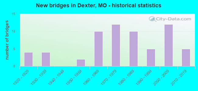
- New bridges - historical statistics
- 41920-1929
- 41930-1939
- 21950-1959
- 101960-1969
- 121970-1979
- 101980-1989
- 51990-1999
- 122000-2009
- 52010-2019
FCC Registered Antenna Towers: 140 (See the full list of FCC Registered Antenna Towers)
FCC Registered Commercial Land Mobile Towers: 2 (See the full list of FCC Registered Commercial Land Mobile Towers in Dexter, MO)
FCC Registered Broadcast Land Mobile Towers: 16 (See the full list of FCC Registered Broadcast Land Mobile Towers)
FCC Registered Microwave Towers: 23 (See the full list of FCC Registered Microwave Towers in this town)
FCC Registered Paging Towers: 3 (See the full list of FCC Registered Paging Towers)
FCC Registered Maritime Coast & Aviation Ground Towers: 2 (See the full list of FCC Registered Maritime Coast & Aviation Ground Towers)
FCC Registered Amateur Radio Licenses: 52 (See the full list of FCC Registered Amateur Radio Licenses in Dexter)
FAA Registered Aircraft Manufacturers and Dealers: 1 (See the full list of FAA Registered Manufacturers and Dealers in Dexter)
FAA Registered Aircraft: 17 (See the full list of FAA Registered Aircraft)
2002 - 2018 National Fire Incident Reporting System (NFIRS) incidents
- Fire incident types reported to NFIRS in Dexter, MO
- 39641.4%Structure Fires
- 36638.3%Outside Fires
- 18419.2%Mobile Property/Vehicle Fires
- 101.0%Other
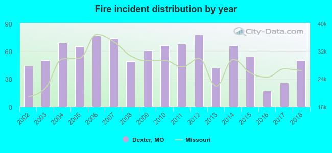 According to the data from the years 2002 - 2018 the average number of fire incidents per year is 56. The highest number of reported fires - 78 took place in 2012, and the least - 17 in 2016. The data has a rising trend.
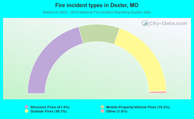 When looking into fire subcategories, the most incidents belonged to: Structure Fires (41.4%), and Outside Fires (38.3%).
Fire-safe hotels and motels in Dexter, Missouri:
- Econolodge, 913 S Outer Rd, Dexter, Missouri 63841 , Phone: (573) 624-7400, Fax: (573) 624-4499
- Americas Best Value Inn, 1802 N Outer Rd, Dexter, Missouri 63841 , Phone: (573) 624-3566, Fax: (573) 624-2078
| Most common first names in Dexter, MO among deceased individuals | ||
| Name | Count | Lived (average) |
|---|---|---|
| John | 135 | 71.4 years |
| William | 126 | 76.2 years |
| James | 114 | 73.7 years |
| Mary | 113 | 77.0 years |
| Charles | 78 | 72.0 years |
| Robert | 63 | 72.9 years |
| George | 52 | 77.6 years |
| Ruth | 42 | 80.7 years |
| Ruby | 35 | 79.3 years |
| Walter | 35 | 78.2 years |
| Most common last names in Dexter, MO among deceased individuals | ||
| Last name | Count | Lived (average) |
|---|---|---|
| Smith | 70 | 77.8 years |
| Miller | 47 | 80.0 years |
| Edwards | 46 | 77.7 years |
| Davis | 40 | 72.7 years |
| Gaines | 37 | 78.1 years |
| Brown | 37 | 79.0 years |
| Williams | 36 | 72.0 years |
| Jones | 34 | 79.8 years |
| Johnson | 33 | 70.8 years |
| Jackson | 29 | 79.8 years |
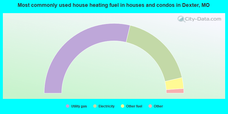
- 57.5%Utility gas
- 35.4%Electricity
- 5.1%Other fuel
- 1.8%Bottled, tank, or LP gas
- 0.3%No fuel used
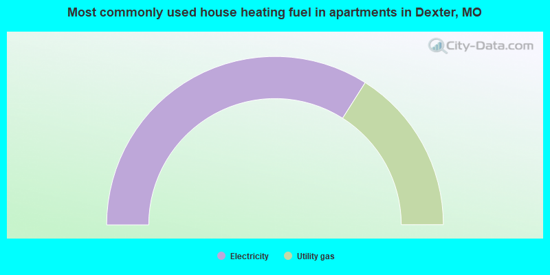
- 68.0%Electricity
- 32.0%Utility gas
Dexter compared to Missouri state average:
- Median house value below state average.
- Unemployed percentage below state average.
- Black race population percentage significantly below state average.
- Median age above state average.
- Foreign-born population percentage significantly below state average.
- Percentage of population with a bachelor's degree or higher below state average.

|
Total of 4 patent applications in 2008-2024.