District 1, Taneytown, Maryland
Submit your own pictures of this city and show them to the world
- OSM Map
- General Map
- Google Map
- MSN Map

| Males: 4,311 | |
| Females: 4,479 |
| Median resident age: | 34.2 years |
| Maryland median age: | 36.0 years |
Zip code: 21787
| District 1, Taneytown: | $83,713 |
| MD: | $94,991 |
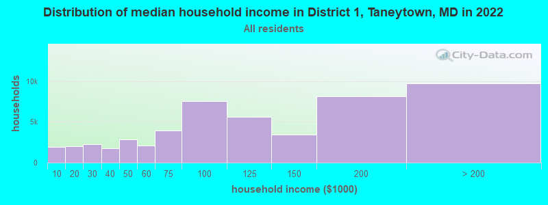
Estimated per capita income in 2022: $38,800 (it was $18,623 in 2000)
District 1, Taneytown income, earnings, and wages data
Estimated median house or condo value in 2022: $338,140 (it was $132,800 in 2000)
| District 1, Taneytown: | $338,140 |
| MD: | $398,100 |
Mean prices in 2022: all housing units: $437,969; detached houses: $459,464; townhouses or other attached units: $306,699; in 2-unit structures: $253,074; in 3-to-4-unit structures: $406,896; in 5-or-more-unit structures: $226,520; mobile homes: $39,227
District 1, Taneytown, MD residents, houses, and apartments details
Detailed information about poverty and poor residents in District 1, Taneytown, MD


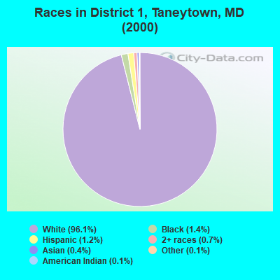
- 7,55896.1%White alone
- 1091.4%Black alone
- 981.2%Hispanic
- 530.7%Two or more races
- 300.4%Asian alone
- 90.1%American Indian alone
- 100.1%Other race alone
Races in District 1, Taneytown detailed stats: ancestries, foreign born residents, place of birth
 Recent articles from our blog. Our writers, many of them Ph.D. graduates or candidates, create easy-to-read articles on a wide variety of topics.
Current Local Time: EST time zone
Land area: 39.1 square miles.
Population density: 225 people per square mile (very low).

| District 1, Taneytown: | 1.1% ($1,487) |
| Maryland: | 1.2% ($1,782) |
Nearest city with pop. 50,000+: Frederick, MD  (21.1 miles , pop. 52,767).
Nearest city with pop. 200,000+: Baltimore, MD (38.6 miles , pop. 651,154).
Nearest city with pop. 1,000,000+: Philadelphia, PA (110.1 miles , pop. 1,517,550).
Nearest cities:
), ), ), )Latitude: 39.66 N, Longitude: 77.17 W

| Here: | 1.6% |
| Maryland: | 2.0% |
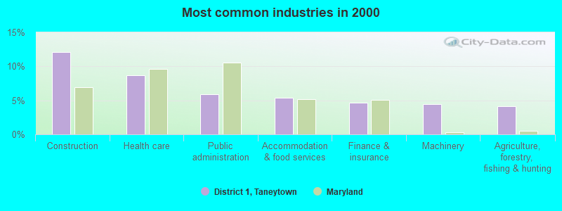
- Construction (12.1%)
- Health care (8.6%)
- Public administration (5.9%)
- Accommodation & food services (5.4%)
- Finance & insurance (4.6%)
- Machinery (4.5%)
- Agriculture, forestry, fishing & hunting (4.1%)

- Construction (21.0%)
- Public administration (6.6%)
- Agriculture, forestry, fishing & hunting (6.1%)
- Machinery (5.2%)
- Professional, scientific, technical services (4.5%)
- Accommodation & food services (4.0%)
- Utilities (2.7%)
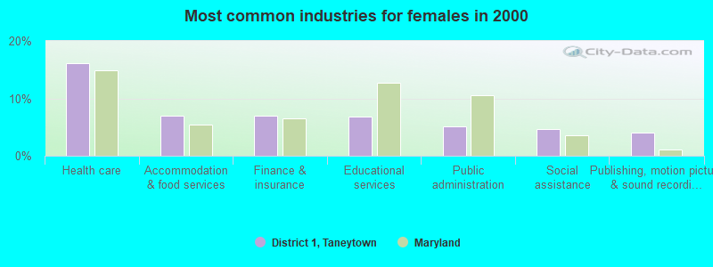
- Health care (16.2%)
- Accommodation & food services (7.0%)
- Finance & insurance (7.0%)
- Educational services (6.8%)
- Public administration (5.1%)
- Social assistance (4.6%)
- Publishing, motion picture & sound recording industries (4.0%)
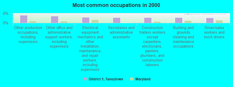
- Other production occupations, including supervisors (4.9%)
- Other office and administrative support workers, including supervisors (4.4%)
- Electrical equipment mechanics and other installation, maintenance, and repair workers, including supervisors (3.6%)
- Secretaries and administrative assistants (3.4%)
- Construction traders workers except carpenters, electricians, painters, plumbers, and construction laborers (3.4%)
- Building and grounds cleaning and maintenance occupations (3.4%)
- Driver/sales workers and truck drivers (3.3%)
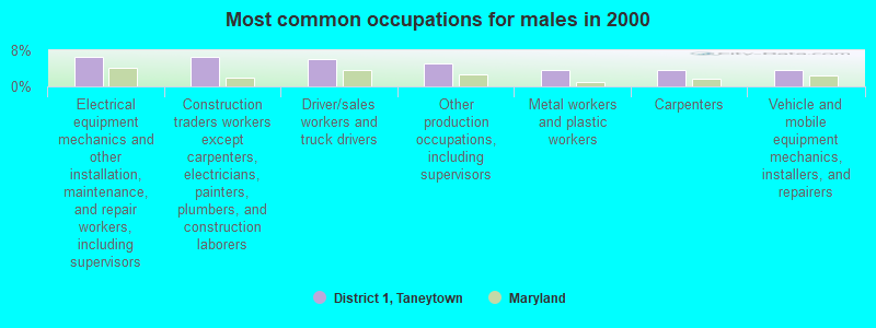
- Electrical equipment mechanics and other installation, maintenance, and repair workers, including supervisors (6.5%)
- Construction traders workers except carpenters, electricians, painters, plumbers, and construction laborers (6.4%)
- Driver/sales workers and truck drivers (6.0%)
- Other production occupations, including supervisors (5.2%)
- Metal workers and plastic workers (3.7%)
- Carpenters (3.7%)
- Vehicle and mobile equipment mechanics, installers, and repairers (3.7%)

- Other office and administrative support workers, including supervisors (8.2%)
- Secretaries and administrative assistants (7.4%)
- Other production occupations, including supervisors (4.5%)
- Building and grounds cleaning and maintenance occupations (3.7%)
- Financial clerks, except bookkeeping, accounting and auditing clerks (3.5%)
- Nursing, psychiatric, and home health aides (3.4%)
- Other food preparation and serving workers, including supervisors (3.4%)
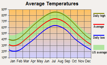
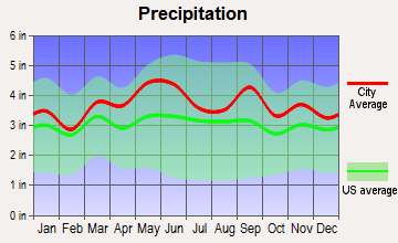
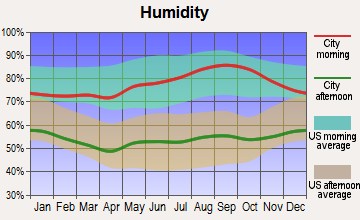
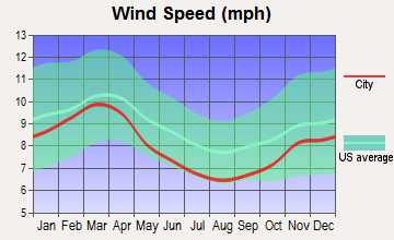
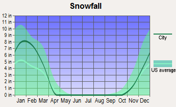
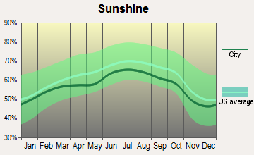
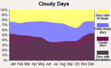
Average climate in District 1, Taneytown, Maryland
Based on data reported by over 4,000 weather stations
(lower is better)
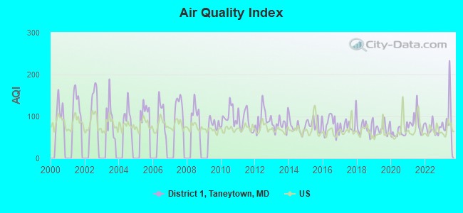
Air Quality Index (AQI) level in 2023 was 92.5. This is worse than average.
| City: | 92.5 |
| U.S.: | 72.6 |
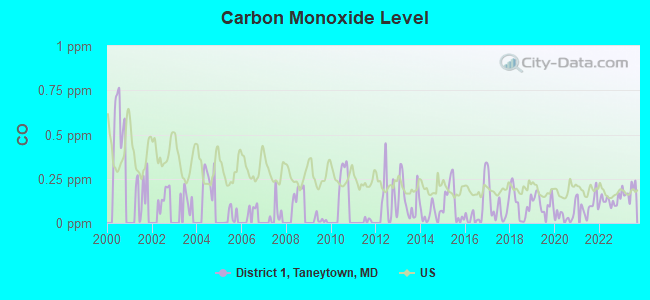
Carbon Monoxide (CO) [ppm] level in 2023 was 0.183. This is better than average. Closest monitor was 19.1 miles away from the city center.
| City: | 0.183 |
| U.S.: | 0.251 |
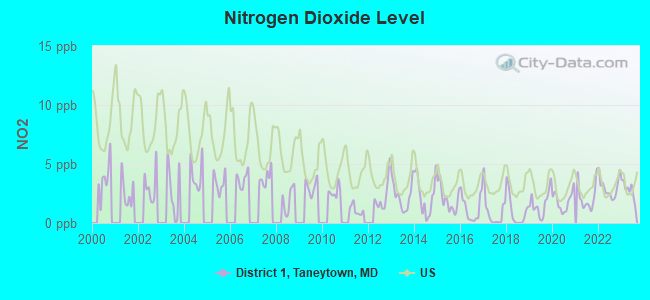
Nitrogen Dioxide (NO2) [ppb] level in 2023 was 2.84. This is significantly better than average. Closest monitor was 9.0 miles away from the city center.
| City: | 2.84 |
| U.S.: | 5.11 |
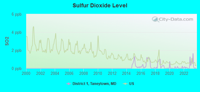
Sulfur Dioxide (SO2) [ppb] level in 2023 was 0.475. This is significantly better than average. Closest monitor was 9.0 miles away from the city center.
| City: | 0.475 |
| U.S.: | 1.515 |
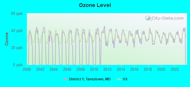
Ozone [ppb] level in 2023 was 38.0. This is about average. Closest monitor was 13.1 miles away from the city center.
| City: | 38.0 |
| U.S.: | 33.3 |
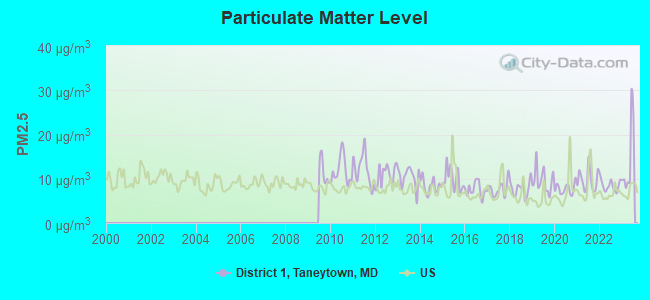
Particulate Matter (PM2.5) [µg/m3] level in 2023 was 14.3. This is significantly worse than average. Closest monitor was 19.1 miles away from the city center.
| City: | 14.3 |
| U.S.: | 8.1 |
Tornado activity:
District 1, Taneytown-area historical tornado activity is slightly above Maryland state average. It is 11% greater than the overall U.S. average.
On 5/22/1983, a category F3 (max. wind speeds 158-206 mph) tornado 4.1 miles away from the District 1, Taneytown city center caused between $5000 and $50,000 in damages.
On 4/5/1952, a category F3 tornado 13.9 miles away from the city center injured 4 people and caused between $500,000 and $5,000,000 in damages.
Earthquake activity:
District 1, Taneytown-area historical earthquake activity is significantly above Maryland state average. It is 57% smaller than the overall U.S. average.On 8/23/2011 at 17:51:04, a magnitude 5.8 (5.8 MW, Depth: 3.7 mi, Class: Moderate, Intensity: VI - VII) earthquake occurred 128.2 miles away from District 1, Taneytown center
On 1/16/1994 at 01:49:16, a magnitude 4.6 (4.6 MB, 4.6 LG, Depth: 3.1 mi, Class: Light, Intensity: IV - V) earthquake occurred 75.8 miles away from District 1, Taneytown center
On 9/25/1998 at 19:52:52, a magnitude 5.2 (4.8 MB, 4.3 MS, 5.2 LG, 4.5 MW, Depth: 3.1 mi) earthquake occurred 211.3 miles away from District 1, Taneytown center
On 8/25/2011 at 05:07:52, a magnitude 4.5 (4.5 ML, Depth: 4.2 mi) earthquake occurred 126.3 miles away from the city center
On 1/16/1994 at 00:42:43, a magnitude 4.2 (4.2 MB, 4.0 LG, Depth: 3.1 mi) earthquake occurred 76.9 miles away from District 1, Taneytown center
On 12/9/2003 at 20:59:18, a magnitude 4.5 (4.5 ML, Depth: 6.2 mi) earthquake occurred 140.0 miles away from the city center
Magnitude types: regional Lg-wave magnitude (LG), body-wave magnitude (MB), local magnitude (ML), surface-wave magnitude (MS), moment magnitude (MW)
Natural disasters:
The number of natural disasters in Carroll County (17) is near the US average (15).Major Disasters (Presidential) Declared: 12
Emergencies Declared: 5
Causes of natural disasters: Hurricanes: 5, Floods: 4, Snowstorms: 3, Storms: 3, Winter Storms: 3, Blizzard: 1, Heavy Rain: 1, Snow: 1, Snowfall: 1, Tropical Storm: 1, Other: 1 (Note: some incidents may be assigned to more than one category).
Hospitals and medical centers near District 1, Taneytown:
- LORIEN TANEYTOWN, INC (Nursing Home, about 2 miles away; TANEYTOWN, MD)
- LITTLESTOWN DIALYSIS CENTER (Dialysis Facility, about 7 miles away; LITTLESTOWN, PA)
- ST JOSEPH'S MINISTRIES (Nursing Home, about 9 miles away; EMMITSBURG, MD)
- ST. VINCENT CARE CENTER (Nursing Home, about 9 miles away; EMMITSBURG, MD)
- THERAPY MANAGEMENT SVCS/DBA COMP REHAB (Hospital, about 12 miles away; WESTMINSTER, MD)
- GETTYSBURG HOSPITAL Acute Care Hospitals (about 12 miles away; GETTYSBURG, PA)
- LUTHERAN HOME CARE AND HOSPICE, INC (Home Health Center, about 12 miles away; WESTMINSTER, MD)
Colleges/universities with over 2000 students nearest to District 1, Taneytown:
- Mount St Mary's University (about 10 miles; Emmitsburg, MD; Full-time enrollment: 2,313)
- McDaniel College (about 11 miles; Westminster, MD; FT enrollment: 2,558)
- Gettysburg College (about 13 miles; Gettysburg, PA; FT enrollment: 2,772)
- Carroll Community College (about 14 miles; Westminster, MD; FT enrollment: 2,682)
- Frederick Community College (about 20 miles; Frederick, MD; FT enrollment: 3,798)
- Hagerstown Community College (about 27 miles; Hagerstown, MD; FT enrollment: 3,220)
- Stevenson University (about 31 miles; Stevenson, MD; FT enrollment: 3,862)
Points of interest:
Notable locations in District 1, Taneytown: Sewells Farm (A), White Rose Farm (B), Mason and Dixon Line (C), Taneytown Industrial Development Area (D), Monocacy Farms (E), Taneytown City Hall (F), Bethesda Police Department District 2 (G), Bowie Volunteer Fire Department and Rescue Squad (H), Carroll County Public Library - Taneytown Branch (I), Carroll County Fire Department Station 5 Taneytown Volunteer Fire Company (J), Taneytown Police Department (K), Carroll County Fire Department Station 11 Harney Volunteer Fire Department (L). Display/hide their locations on the map
Shopping Center: Taneytown Shopping Center (1). Display/hide its location on the map
Churches in District 1, Taneytown include: Piney Creek Presbyterian Church (A), Piney Creek Church (B), Grace United Church of Christ (C), Saint Josephs Roman Catholic Church (D), Saint Pauls Lutheran Church (E), Taneytown Baptist Church (F), Taneytown Presbyterian Church (G). Display/hide their locations on the map
Cemeteries: Sunrise Cemetery (1), Mount Pleasant Cemetery (2), Mountainview Cemetery (3), Trinity Cemetery (4), Saint Joseph Cemetery (5), Piney Creek Cemetery (6), Grace Cemetery (7). Display/hide their locations on the map
Streams, rivers, and creeks: Alloway Creek (A), Silver Run (B). Display/hide their locations on the map
Parks in District 1, Taneytown include: Big Pipe Creek Park (1), Roth Recreational Park (2), Taneytown Memorial Park (3), Taneytown Historic District (4), Roberts Mill Park (5). Display/hide their locations on the map
| This city: | 2.7 people |
| Maryland: | 2.6 people |
| This city: | 75.1% |
| Whole state: | 67.1% |
| This city: | 7.4% |
| Whole state: | 6.4% |
Likely homosexual households (counted as self-reported same-sex unmarried-partner households)
- Lesbian couples: 0.5% of all households
- Gay men: 0.1% of all households
| This city: | 8.5% |
| Whole state: | 8.5% |
| This city: | 4.2% |
| Whole state: | 4.2% |
8 people in other noninstitutional group quarters in 2000
3 people in homes for the mentally retarded in 2000
For population 15 years and over in District 1, Taneytown:
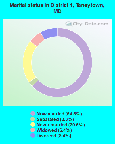
- Never married: 20.6%
- Now married: 64.5%
- Separated: 2.3%
- Widowed: 6.4%
- Divorced: 8.4%
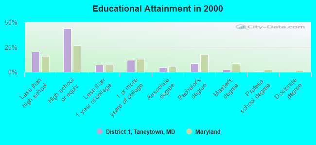
For population 25 years and over in District 1, Taneytown:
- High school or higher: 79.5%
- Bachelor's degree or higher: 12.1%
- Graduate or professional degree: 3.3%
- Unemployed: 3.8%
- Mean travel time to work (commute): 30.8 minutes
| Here: | 10.3 |
| Maryland average: | 12.7 |
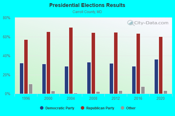
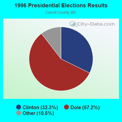
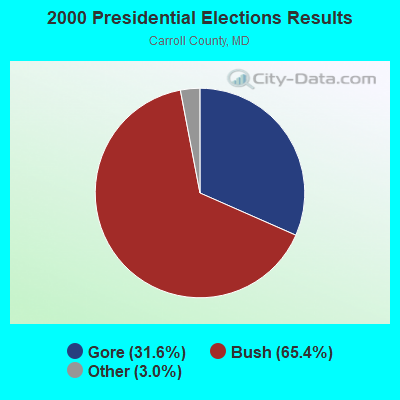


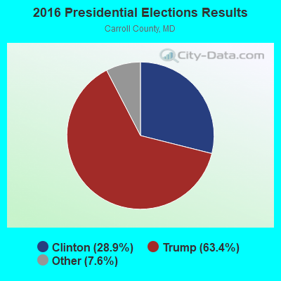
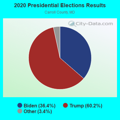
Graphs represent county-level data. Detailed 2008 Election Results
Religion statistics for District 1, Taneytown, MD (based on Carroll County data)
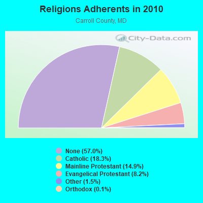
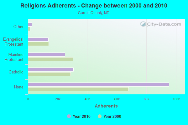
| Religion | Adherents | Congregations |
|---|---|---|
| Catholic | 30,551 | 4 |
| Mainline Protestant | 24,903 | 75 |
| Evangelical Protestant | 13,764 | 68 |
| Other | 2,472 | 9 |
| Orthodox | 226 | 2 |
| None | 95,218 | - |
Food Environment Statistics:
| Carroll County: | 1.18 / 10,000 pop. |
| Maryland: | 1.96 / 10,000 pop. |
| Carroll County: | 0.06 / 10,000 pop. |
| Maryland: | 0.07 / 10,000 pop. |
| This county: | 1.01 / 10,000 pop. |
| Maryland: | 1.22 / 10,000 pop. |
| Carroll County: | 1.84 / 10,000 pop. |
| State: | 2.05 / 10,000 pop. |
| Carroll County: | 5.63 / 10,000 pop. |
| State: | 5.40 / 10,000 pop. |
| Carroll County: | 7.6% |
| State: | 9.1% |
| Here: | 24.5% |
| State: | 26.7% |
| This county: | 13.8% |
| Maryland: | 15.5% |
6.27% of this county's 2020 resident taxpayers moved to other counties in 2021 ($82,015 average adjusted gross income)
| Here: | 6.27% |
| Maryland average: | 7.91% |
0.03% of residents moved to foreign countries ($566 average AGI)
Carroll County: 0.03% Maryland average: 0.04%
Top counties to which taxpayers relocated from this county between 2020 and 2021:
| to Baltimore County, MD | |
| to Frederick County, MD | |
| to York County, PA |
Strongest AM radio stations in District 1, Taneytown:
- WCBM (680 AM; 50 kW; BALTIMORE, MD; Owner: WCBM MARYLAND, INC.)
- WBAL (1090 AM; 50 kW; BALTIMORE, MD; Owner: HEARST RADIO, INC.)
- WGOP (700 AM; daytime; 25 kW; WALKERSVILLE, MD; Owner: BIRACH BROADCASTING CORPORATION)
- WMET (1150 AM; 50 kW; GAITHERSBURG, MD; Owner: BELTWAY ACQUISITION CORPORATION)
- WHVR (1280 AM; 5 kW; HANOVER, PA)
- WTEM (980 AM; 50 kW; WASHINGTON, DC; Owner: AMFM RADIO LICENSES, L.L.C.)
- WWLG (1370 AM; 50 kW; BALTIMORE, MD; Owner: M-10 BROADCASTING, INC.)
- WTOP (1500 AM; 50 kW; WASHINGTON, DC; Owner: BONNEVILLE HOLDING COMPANY)
- WBIS (1190 AM; 50 kW; ANNAPOLIS, MD; Owner: NATIONS RADIO, LLC)
- WCAO (600 AM; 5 kW; BALTIMORE, MD; Owner: CITICASTERS LICENSES, L.P.)
- WTRI (1520 AM; daytime; 17 kW; BRUNSWICK, MD; Owner: JMK COMMUNICATIONS, INC.)
- WPGC (1580 AM; 50 kW; MORNINGSIDE, MD; Owner: INFINITY WPGC(AM), INC.)
- WFMD (930 AM; 5 kW; FREDERICK, MD; Owner: CAPSTAR TX LIMITED PARTNERSHIP)
Strongest FM radio stations in District 1, Taneytown:
- WAYZ-FM (104.7 FM; HAGERSTOWN, MD; Owner: HJV LIMITED PARTNERSHIP)
- WETH (89.1 FM; HAGERSTOWN, MD; Owner: GREATER WASHINGTON EDUCATIONAL TELECOMMUNICATIONS ASSN.)
- WFRE (99.9 FM; FREDERICK, MD; Owner: CAPSTAR TX LIMITED PARTNERSHIP)
- WYCR (98.5 FM; YORK-HANOVER, PA; Owner: RADIO HANOVER, INC.)
- W219BX (91.7 FM; FREDERICK, MD; Owner: CEDAR RIDGE CHILDREN'S HOME & SCHOOL, INC)
- WGTY (107.7 FM; GETTYSBURG, PA; Owner: TIMES AND NEWS PUBLISHING COMPANY)
- W219BE (91.7 FM; WAYNESBORO, PA; Owner: MARANATHA BIBLE INSTITUTE, NDBA)
- WWVZ (103.9 FM; BRADDOCK HEIGHTS, MD; Owner: BONNEVILLE HOLDING COMPANY)
- WZBT (91.1 FM; GETTYSBURG, PA; Owner: GETTYSBURG COLLEGE)
- WZBA (100.7 FM; WESTMINSTER, MD; Owner: SHAMROCK COMMUNICATIONS, INC.)
- WARX (106.9 FM; HAGERSTOWN, MD; Owner: MANNING BROADCASTING INC.)
- WWMX (106.5 FM; BALTIMORE, MD; Owner: INFINITY RADIO OPERATIONS INC.)
- WROZ (101.3 FM; LANCASTER, PA; Owner: HALL COMMUNICATIONS, INC.)
- WARM-FM (103.3 FM; YORK, PA; Owner: WSBA LICO, INC.)
- WEEO-FM (103.7 FM; MCCONNELLSBURG, PA; Owner: ALLEGHENY MOUNTAIN NETWORK)
- WHBO (92.7 FM; STARVIEW, PA; Owner: HALL COMMUNICATIONS, INC.)
- WSOX (96.1 FM; RED LION, PA; Owner: LANCASTER-YORK BROADCASTING, LLC)
- WIYY (97.9 FM; BALTIMORE, MD; Owner: HEARST RADIO, INC.)
- WLIF (101.9 FM; BALTIMORE, MD; Owner: INFINITY WLIF, INC.)
- WPOC (93.1 FM; BALTIMORE, MD; Owner: CITICASTERS LICENSES, L.P.)
TV broadcast stations around District 1, Taneytown:
- WMPB (Channel 67; BALTIMORE, MD; Owner: MARYLAND PUBLIC BROADCASTING COMMISSION)
- WBAL-TV (Channel 11; BALTIMORE, MD; Owner: WBAL HEARST-ARGYLE TV, INC. (CA CORP.))
- WMAR-TV (Channel 2; BALTIMORE, MD; Owner: SCRIPPS HOWARD BROADCASTING COMPANY)
- WBFF (Channel 45; BALTIMORE, MD; Owner: CHESAPEAKE TELEVISION LICENSEE, LLC)
- WNUV (Channel 54; BALTIMORE, MD; Owner: BALTIMORE (WNUV-TV) LICENSEE, INC.)
- WJZ-TV (Channel 13; BALTIMORE, MD; Owner: VIACOM INC.)
- WUTB (Channel 24; BALTIMORE, MD; Owner: FOX TELEVISION STATIONS, INC.)
- WPMT (Channel 43; YORK, PA; Owner: TRIBUNE TELEVISION COMPANY)
- WGAL (Channel 8; LANCASTER, PA; Owner: WGAL HEARST-ARGYLE TELEVISION, INC.)
- WFPT (Channel 62; FREDERICK, MD; Owner: MARYLAND PUBLIC BROADCASTING COMMISSION)
- W52AS (Channel 52; FREDERICK, MD; Owner: THREE ANGELS BROADCASTING NETWORK)
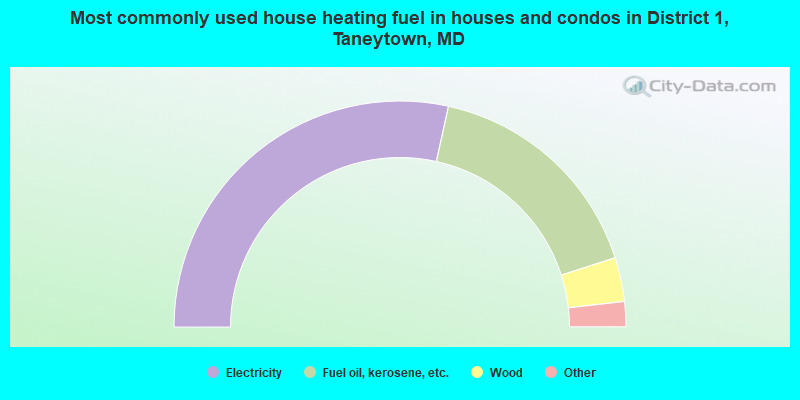
- 56.9%Electricity
- 33.2%Fuel oil, kerosene, etc.
- 6.3%Wood
- 1.4%Bottled, tank, or LP gas
- 0.7%Utility gas
- 0.7%Other fuel
- 0.4%Coal or coke
- 0.3%No fuel used
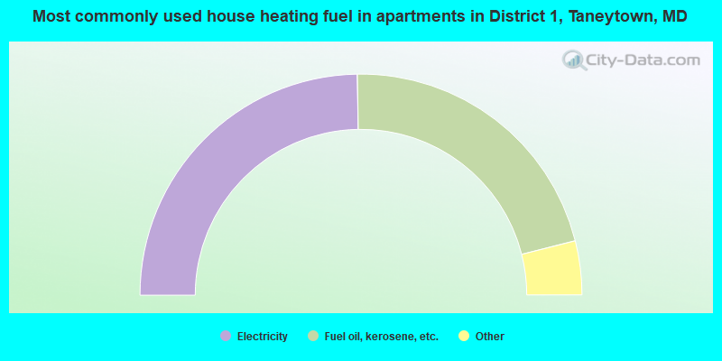
- 49.5%Electricity
- 42.6%Fuel oil, kerosene, etc.
- 3.8%Bottled, tank, or LP gas
- 2.5%Wood
- 1.1%Other fuel
- 0.6%Utility gas
District 1, Taneytown compared to Maryland state average:
- Unemployed percentage significantly below state average.
- Black race population percentage significantly below state average.
- Hispanic race population percentage significantly below state average.
- Foreign-born population percentage significantly below state average.
- Renting percentage below state average.
- Length of stay since moving in significantly above state average.
- Number of rooms per house significantly below state average.
- House age significantly below state average.
- Number of college students below state average.
- Percentage of population with a bachelor's degree or higher significantly below state average.
District 1, Taneytown on our top lists:
- #13 on the list of "Top 101 cities with largest percentage of females in industries: publishing, and motion picture and sound recording industries (population 5,000+)"
- #15 on the list of "Top 101 cities with largest percentage of males in occupations: woodworkers (population 5,000+)"
- #22 on the list of "Top 101 cities with largest percentage of females in occupations: other food preparation and serving workers including supervisors (population 5,000+)"
- #23 on the list of "Top 101 cities with largest percentage of females in industries: machinery (population 5,000+)"
- #38 on the list of "Top 101 cities with largest percentage of males in industries: used merchandise, gift, novelty, and souvenir, and other miscellaneous stores (population 5,000+)"
- #43 on the list of "Top 101 cities with largest percentage of males in occupations: construction trades workers except carpenters, electricians, painters, plumbers, and construction laborers (population 5,000+)"
- #49 on the list of "Top 101 cities with largest percentage of females in industries: wood products (population 5,000+)"
- #50 on the list of "Top 101 cities with largest percentage of males in industries: machinery (population 5,000+)"
- #52 on the list of "Top 101 cities with largest percentage of females in industries: apparel (population 5,000+)"
- #54 on the list of "Top 101 cities with largest percentage of females in industries: rail transportation (population 5,000+)"
- #58 on the list of "Top 101 cities with largest percentage of females in industries: miscellaneous nondurable goods merchant wholesalers (population 5,000+)"
- #62 on the list of "Top 101 cities with largest percentage of females in industries: nonmetallic mineral products (population 5,000+)"
- #69 on the list of "Top 101 cities with largest percentage of females in occupations: financial clerks except bookkeeping, accounting, and auditing clerks (population 5,000+)"
- #70 on the list of "Top 101 cities with largest percentage of females in industries: furniture and related product manufacturing (population 5,000+)"
- #74 on the list of "Top 101 cities with largest percentage of females in occupations: painters and paperhangers (population 5,000+)"
- #75 on the list of "Top 101 cities with the most cars per house, population 5,000+"
- #76 on the list of "Top 101 cities with largest percentage of males in industries: furniture and related product manufacturing (population 5,000+)"
- #82 on the list of "Top 101 cities with largest percentage of males in occupations: other food preparation and serving workers including supervisors (population 5,000+)"
- #85 on the list of "Top 100 low-educated but high-earning cities (pop. 5,000+)"
- #92 on the list of "Top 101 cities with largest percentage of females in industries: beverage and tobacco products (population 5,000+)"
- #17 on the list of "Top 101 counties with the largest decrease in the number of births per 1000 residents 2000-2006 to 2007-2013 (pop 50,000+)"
- #29 on the list of "Top 101 counties with the lowest average weight of females"
- #36 on the list of "Top 101 counties with the lowest percentage of residents that exercised in the past month"
- #53 on the list of "Top 101 counties with the lowest number of births per 1000 residents 2007-2013"
- #58 on the list of "Top 101 counties with the highest percentage of residents that visited a dentist within the past year"