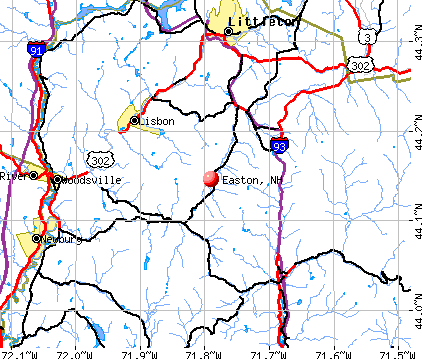
Easton, New Hampshire

Submit your own pictures of this town and show them to the world
- OSM Map
- General Map
- Google Map
- MSN Map
Population change since 2000: -0.8%
 |
| Males: 131 | |
| Females: 123 |
| Median resident age: | 54.9 years |
| New Hampshire median age: | 43.9 years |
Zip codes: 03580.
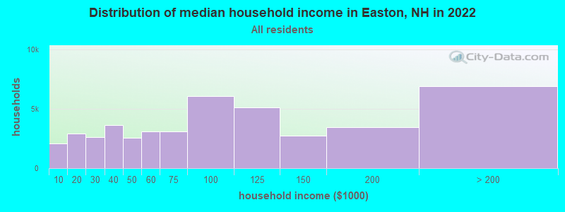
| Easton: | $96,132 |
| NH: | $89,992 |
Estimated per capita income in 2022: $72,406 (it was $31,841 in 2000)
Easton town income, earnings, and wages data
Estimated median house or condo value in 2022: $460,257 (it was $144,000 in 2000)
| Easton: | $460,257 |
| NH: | $384,700 |
Mean prices in 2022: all housing units: $486,096; detached houses: $533,852; townhouses or other attached units: $375,744; in 2-unit structures: $230,260; in 3-to-4-unit structures: $242,363; in 5-or-more-unit structures: $588,257; mobile homes: $127,035
Detailed information about poverty and poor residents in Easton, NH
Compare current foreclosures near Easton, NH:
| Photo | Address | Area | Beds / Baths | Price | Details |
|---|---|---|---|---|---|

|
#1
Saint Johnsbury Rd
Littleton, NH 03561
|
1,672 sq. feet
|
1 baths 3 beds |
show details | |

|
#2
Sugar Hill Rd
Franconia, NH 03580
|
- sq. feet
|
- baths - beds |
show details | |

|
#3
Nh Route 118
Warren, NH 03279
|
- sq. feet
|
- baths - beds |
show details | |

|
#4
Depot St
Haverhill, NH 03765
|
- sq. feet
|
- baths - beds |
show details | |

|
#5
Mountain View Dr
Monroe, NH 03771
|
- sq. feet
|
- baths - beds |
show details | |

|
#6
Adams Dr
Woodsville, NH 03785
|
- sq. feet
|
- baths - beds |
show details | |

|
#7
Bishop Rd
Lisbon, NH 03585
|
- sq. feet
|
- baths - beds |
show details | |

|
#8
Eastside Rd
North Woodstock, NH 03262
|
- sq. feet
|
- baths - beds |
show details | |

|
#9
Maciver Rd
Littleton, NH 03561
|
- sq. feet
|
- baths - beds |
show details | |

|
#10
Washington St
Littleton, NH 03561
|
- sq. feet
|
- baths - beds |
show details |
| Photo | Address | Area | Beds / Baths | Price | Details |
|---|---|---|---|---|---|

|
Check over 1 million property listings on Foreclosure.com!
|
browse all offers | |||
| Photo | Address | Area | Beds / Baths | Price | Details |
|---|

- 24897.6%White alone
- 20.8%American Indian alone
- 20.8%Other race alone
- 10.4%Two or more races
- 10.4%Hispanic
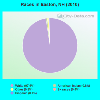
Races in Easton detailed stats: ancestries, foreign born residents, place of birth
According to our research of New Hampshire and other state lists, there were 2 registered sex offenders living in Easton, New Hampshire as of May 17, 2024.
The ratio of all residents to sex offenders in Easton is 127 to 1.
 Recent articles from our blog. Our writers, many of them Ph.D. graduates or candidates, create easy-to-read articles on a wide variety of topics.

 | Possible Relocation to New Hampshire (30 replies) |
| Thinking of moving to NH....no clue where (11 replies) |
| Moving from CT to southern NH, looking at Windham or Bedford (20 replies) |
| Moving to Manchester area 6/2019 (2 replies) |
| Moving to New Hampshire. (16 replies) |
| The Facts about NH Property Taxes (9 replies) |
Latest news from Easton, NH collected exclusively by city-data.com from local newspapers, TV, and radio stations
Ancestries: English (30.5%), Irish (25.8%), German (15.2%), Italian (12.5%), French (12.1%), Scottish (7.8%).
Current Local Time: EST time zone
Incorporated in 1876
Elevation: 1167 feet
Land area: 31.2 square miles.
Population density: 8.1 people per square mile (very low).
7 residents are foreign born (2.0% Europe, 0.8% Asia).
| This town: | 2.7% |
| New Hampshire: | 4.4% |
| Easton town: | 1.7% ($2,389) |
| New Hampshire: | 2.3% ($2,946) |
Nearest city with pop. 50,000+: Manchester, NH  (81.0 miles , pop. 107,006).
Nearest city with pop. 200,000+: Boston, MA (130.1 miles , pop. 589,141).
Nearest city with pop. 1,000,000+: Bronx, NY (250.5 miles , pop. 1,332,650).
Nearest cities:
), ), ), Latitude: 44.13 N, Longitude: 71.80 W
Area code commonly used in this area: 603

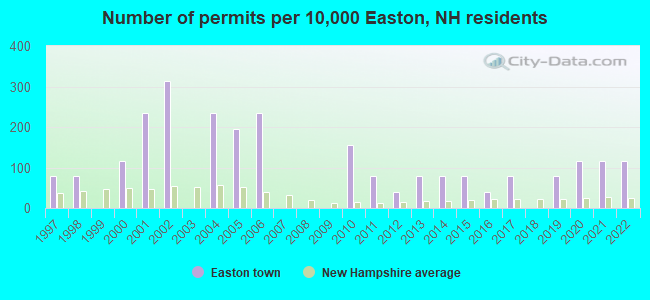
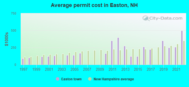
Single-family new house construction building permits:
- 2022: 3 buildings, average cost: $500,000
- 2021: 3 buildings, average cost: $259,200
- 2020: 3 buildings, average cost: $248,200
- 2019: 2 buildings, average cost: $350,000
- 2017: 2 buildings, average cost: $225,000
- 2016: 1 building, cost: $261,800
- 2015: 2 buildings, average cost: $125,000
- 2014: 2 buildings, average cost: $125,000
- 2013: 2 buildings, average cost: $275,000
- 2012: 1 building, cost: $400,000
- 2011: 2 buildings, average cost: $350,000
- 2010: 4 buildings, average cost: $165,900
- 2006: 6 buildings, average cost: $171,000
- 2005: 5 buildings, average cost: $138,800
- 2004: 6 buildings, average cost: $138,800
- 2002: 8 buildings, average cost: $130,700
- 2001: 6 buildings, average cost: $121,400
- 2000: 3 buildings, average cost: $118,000
- 1998: 2 buildings, average cost: $101,700
- 1997: 2 buildings, average cost: $91,700
| Here: | 2.1% |
| New Hampshire: | 2.5% |
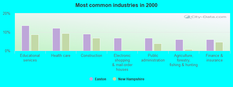
- Educational services (13.5%)
- Health care (12.0%)
- Construction (9.0%)
- Electronic shopping & mail-order houses (6.8%)
- Public administration (6.8%)
- Agriculture, forestry, fishing & hunting (6.0%)
- Finance & insurance (6.0%)
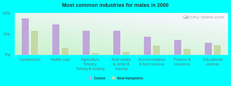
- Construction (17.6%)
- Health care (14.7%)
- Agriculture, forestry, fishing & hunting (11.8%)
- Real estate & rental & leasing (11.8%)
- Accommodation & food services (8.8%)
- Finance & insurance (7.4%)
- Educational services (5.9%)
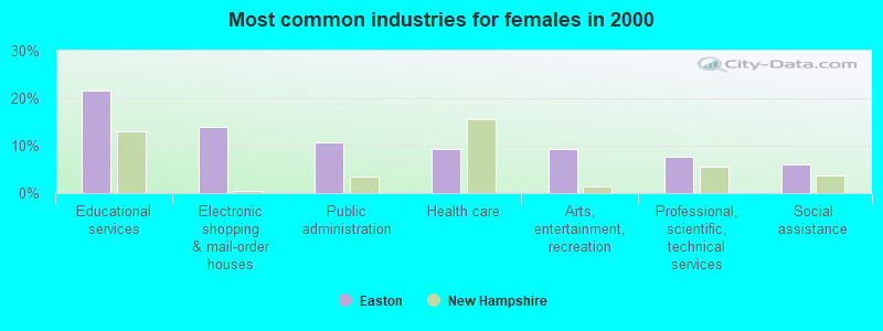
- Educational services (21.5%)
- Electronic shopping & mail-order houses (13.8%)
- Public administration (10.8%)
- Health care (9.2%)
- Arts, entertainment, recreation (9.2%)
- Professional, scientific, technical services (7.7%)
- Social assistance (6.2%)
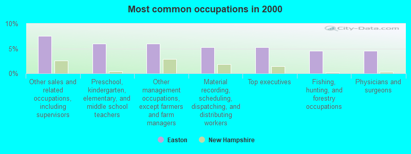
- Other sales and related occupations, including supervisors (7.5%)
- Preschool, kindergarten, elementary, and middle school teachers (6.0%)
- Other management occupations, except farmers and farm managers (6.0%)
- Material recording, scheduling, dispatching, and distributing workers (5.3%)
- Top executives (5.3%)
- Fishing, hunting, and forestry occupations (4.5%)
- Physicians and surgeons (4.5%)
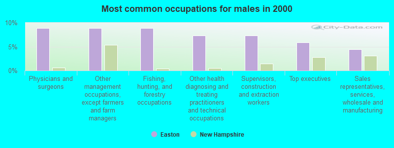
- Physicians and surgeons (8.8%)
- Other management occupations, except farmers and farm managers (8.8%)
- Fishing, hunting, and forestry occupations (8.8%)
- Other health diagnosing and treating practitioners and technical occupations (7.4%)
- Supervisors, construction and extraction workers (7.4%)
- Top executives (5.9%)
- Sales representatives, services, wholesale and manufacturing (4.4%)
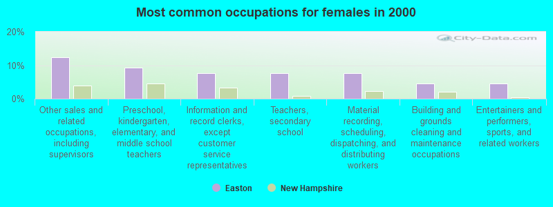
- Other sales and related occupations, including supervisors (12.3%)
- Preschool, kindergarten, elementary, and middle school teachers (9.2%)
- Information and record clerks, except customer service representatives (7.7%)
- Teachers, secondary school (7.7%)
- Material recording, scheduling, dispatching, and distributing workers (7.7%)
- Building and grounds cleaning and maintenance occupations (4.6%)
- Entertainers and performers, sports, and related workers (4.6%)
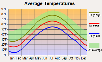
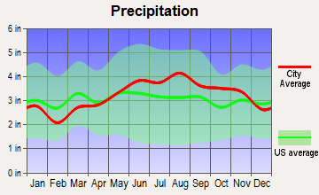
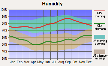
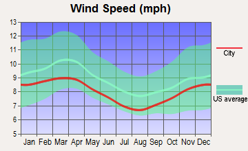
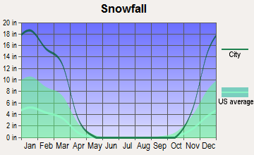
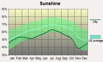
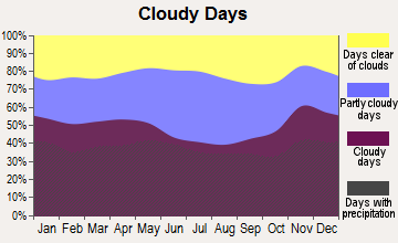
Average climate in Easton, New Hampshire
Based on data reported by over 4,000 weather stations
(lower is better)
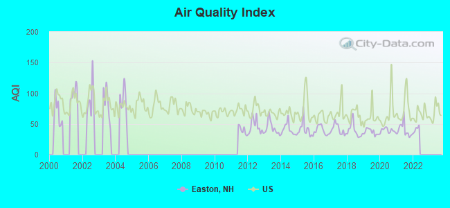
Air Quality Index (AQI) level in 2021 was 39.8. This is significantly better than average.
| City: | 39.8 |
| U.S.: | 72.6 |
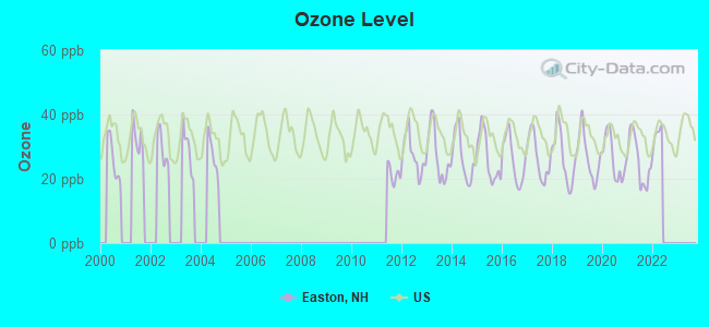
Ozone [ppb] level in 2021 was 25.7. This is better than average. Closest monitor was 5.3 miles away from the city center.
| City: | 25.7 |
| U.S.: | 33.3 |
Tornado activity:
Easton-area historical tornado activity is significantly below New Hampshire state average. It is 80% smaller than the overall U.S. average.
On 8/11/1966, a category F2 (max. wind speeds 113-157 mph) tornado 7.7 miles away from the Easton town center caused between $50,000 and $500,000 in damages.
On 5/11/1973, a category F2 tornado 39.4 miles away from the town center .
Earthquake activity:
Easton-area historical earthquake activity is significantly above New Hampshire state average. It is 72% smaller than the overall U.S. average.On 4/20/2002 at 10:50:47, a magnitude 5.3 (5.3 ML, Depth: 3.0 mi, Class: Moderate, Intensity: VI - VII) earthquake occurred 97.6 miles away from the city center
On 4/20/2002 at 10:50:47, a magnitude 5.2 (5.2 MB, 4.2 MS, 5.2 MW, 5.0 MW) earthquake occurred 98.1 miles away from the city center
On 10/7/1983 at 10:18:46, a magnitude 5.3 (5.1 MB, 5.3 LG, 5.1 ML) earthquake occurred 127.0 miles away from the city center
On 1/19/1982 at 00:14:42, a magnitude 4.7 (4.5 MB, 4.7 MD, 4.5 LG, Class: Light, Intensity: IV - V) earthquake occurred 44.7 miles away from Easton center
On 10/16/2012 at 23:12:25, a magnitude 4.7 (4.7 ML, Depth: 10.0 mi) earthquake occurred 67.9 miles away from the city center
On 6/16/1995 at 12:13:11, a magnitude 3.8 (3.8 LG, Depth: 3.1 mi, Class: Light, Intensity: II - III) earthquake occurred 12.3 miles away from Easton center
Magnitude types: regional Lg-wave magnitude (LG), body-wave magnitude (MB), duration magnitude (MD), local magnitude (ML), surface-wave magnitude (MS), moment magnitude (MW)
Natural disasters:
The number of natural disasters in Grafton County (32) is a lot greater than the US average (15).Major Disasters (Presidential) Declared: 20
Emergencies Declared: 9
Causes of natural disasters: Floods: 16, Storms: 16, Hurricanes: 3, Snows: 3, Winter Storms: 3, Tropical Storms: 2, Blizzard: 1, Heavy Rain: 1, Ice Storm: 1, Landslide: 1, Snowfall: 1, Snowstorm: 1, Wind: 1, Other: 1 (Note: some incidents may be assigned to more than one category).

Hospitals and medical centers near Easton:
- COTTAGE HOSPITAL Critical Access Hospitals (about 8 miles away; WOODSVILLE, NH)
- LAFAYETTE CENTER, GENESIS HEALTHCARE (Nursing Home, about 8 miles away; FRANCONIA, NH)
- GLENCLIFF HOME FOR THE ELDERLY (Nursing Home, about 11 miles away; GLENCLIFF, NH)
- NORTH COUNTRY HOME HEALTH AND HOSPICE AGENCY (Home Health Center, about 12 miles away; LITTLETON, NH)
- GRAFTON COUNTY NURSING HOME (Nursing Home, about 12 miles away; NORTH HAVERHILL, NH)
Colleges/universities with over 2000 students nearest to Easton:
- Plymouth State University (about 27 miles; Plymouth, NH; Full-time enrollment: 4,838)
- Dartmouth College (about 39 miles; Hanover, NH; FT enrollment: 6,030)
- Norwich University (about 43 miles; Northfield, VT; FT enrollment: 4,221)
- NHTI-Concord's Community College (about 65 miles; Concord, NH; FT enrollment: 2,865)
- Saint Joseph's College of Maine (about 69 miles; Standish, ME; FT enrollment: 2,010)
- Middlebury College (about 69 miles; Middlebury, VT; FT enrollment: 3,077)
- Saint Michael's College (about 73 miles; Colchester, VT; FT enrollment: 2,336)
Points of interest:
Notable locations in Easton: Bungay Corner (A), Wildwood Forest Camp (B), Wildwood Campground and Picnic Area (C), Kinsman Cabin (D), Easton Volunteer Fire Department (E). Display/hide their locations on the map
Cemetery: Kinsman Cemetery (1). Display/hide its location on the map
Lake: Mud Pond (A). Display/hide its location on the map
Streams, rivers, and creeks: Reel Brook (A), Clay Brook (B), Bowen Brook (C), Black Brook (D), Slide Brook (E), Kendall Brook (F), Tunnel Brook (G), Underhill Brook (H), Judd Brook (I). Display/hide their locations on the map
Birthplace of: Bode Miller - Alpine skier.
| This town: | 2.1 people |
| New Hampshire: | 2.5 people |
| This town: | 67.5% |
| Whole state: | 66.3% |
| This town: | 8.3% |
| Whole state: | 8.3% |
Likely homosexual households (counted as self-reported same-sex unmarried-partner households)
- Lesbian couples: 1.7% of all households
- Gay men: 2.5% of all households
| This town: | 10.0% |
| Whole state: | 6.5% |
| This town: | 7.6% |
| Whole state: | 2.8% |
For population 15 years and over in Easton:
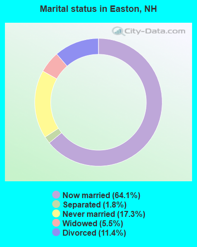
- Never married: 17.3%
- Now married: 64.1%
- Separated: 1.8%
- Widowed: 5.5%
- Divorced: 11.4%
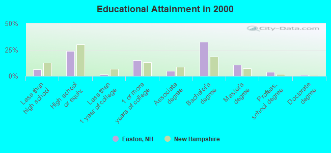
For population 25 years and over in Easton:
- High school or higher: 93.9%
- Bachelor's degree or higher: 48.2%
- Graduate or professional degree: 15.7%
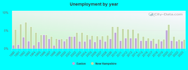
- Unemployed: 6.3%
- Mean travel time to work (commute): 31.8 minutes
| Here: | 10.0 |
| New Hampshire average: | 10.9 |


Graphs represent county-level data. Detailed 2008 Election Results
Religion statistics for Easton, NH (based on Grafton County data)


| Religion | Adherents | Congregations |
|---|---|---|
| Catholic | 9,503 | 12 |
| Mainline Protestant | 7,832 | 57 |
| Evangelical Protestant | 1,494 | 29 |
| Other | 1,320 | 11 |
| None | 68,969 | - |
Food Environment Statistics:
| This county: | 3.87 / 10,000 pop. |
| State: | 2.14 / 10,000 pop. |
| Here: | 0.23 / 10,000 pop. |
| New Hampshire: | 0.15 / 10,000 pop. |
| Grafton County: | 1.29 / 10,000 pop. |
| New Hampshire: | 1.78 / 10,000 pop. |
| Grafton County: | 6.45 / 10,000 pop. |
| New Hampshire: | 4.02 / 10,000 pop. |
| Here: | 14.41 / 10,000 pop. |
| New Hampshire: | 9.70 / 10,000 pop. |
| This county: | 7.2% |
| New Hampshire: | 7.6% |
| Grafton County: | 22.9% |
| State: | 24.4% |
| This county: | 15.9% |
| New Hampshire: | 15.9% |
Strongest AM radio stations in Easton:
- WTWN (1100 AM; daytime; 5 kW; WELLS RIVER, VT; Owner: PUFFER BROADCASTING, INC.)
- WPNH (1300 AM; 5 kW; PLYMOUTH, NH; Owner: NORTHEAST COMMUNICATIONS CORPORATION)
- WRKO (680 AM; 50 kW; BOSTON, MA; Owner: ENTERCOM BOSTON LICENSE, LLC)
- WCHP (760 AM; 35 kW; CHAMPLAIN, NY; Owner: CHAMPLAIN RADIO, INC.)
- WLTN (1400 AM; 1 kW; LITTLETON, NH; Owner: PROFILE BROADCASTING COMPANY, INC.)
- WNNZ (640 AM; 50 kW; WESTFIELD, MA; Owner: CLEAR CHANNEL BROADCASTING LICENSES, INC.)
- WCRN (830 AM; 50 kW; WORCESTER, MA; Owner: CARTER BROADCASTING CORPORATION)
- WDEV (550 AM; 5 kW; WATERBURY, VT; Owner: RADIO VERMONT, INC.)
- WEEI (850 AM; 50 kW; BOSTON, MA; Owner: ENTERCOM BOSTON LICENSE, LLC)
- WNTK (1020 AM; 10 kW; NEWPORT, NH; Owner: KOOR COMMUNICATIONS, INC.)
- WGY (810 AM; 50 kW; SCHENECTADY, NY; Owner: CLEAR CHANNEL BROADCASTING LICENSES, INC.)
- WTME (780 AM; 10 kW; RUMFORD, ME; Owner: MOUNTAIN VALLEY BROADCASTING, INC.)
- WBZ (1030 AM; 50 kW; BOSTON, MA; Owner: INFINITY BROADCASTING OPERATIONS, INC.)
Strongest FM radio stations in Easton:
- WPKQ (103.7 FM; NORTH CONWAY, NH; Owner: CITADEL BROADCASTING COMPANY)
- WHOM (94.9 FM; MT. WASHINGTON, NH; Owner: CITADEL BROADCASTING COMPANY)
- WVFM (105.7 FM; CAMPTON, NH; Owner: DEVON BROADCASTING COMPANY, INC.)
- WLTN-FM (96.7 FM; LISBON, NH; Owner: PROFILE BROADCASTING CO., INC.)
- WMTK (106.3 FM; LITTLETON, NH; Owner: VERMONT BROADCAST ASSOCIATES, INC.)
- WGMT (97.7 FM; LYNDON, VT; Owner: VERMONT BROADCAST ASSOCIATES, INC.)
- WSCY (106.9 FM; MOULTONBOROUGH, NH; Owner: NORTHEAST COMMUNICATIONS CORPORATION)
- WXXS (102.3 FM; LANCASTER, NH; Owner: BARRY P. LUNDERVILLE)
- WYKR-FM (101.3 FM; HAVERHILL, NH; Owner: PUFFER BROADCASTING, INC.)
- WPNH-FM (100.1 FM; PLYMOUTH, NH; Owner: NORTHEAST COMMUNICATIONS CORPORATION)
- WDOT (95.7 FM; DANVILLE, VT; Owner: MONTPELIER BROADCASTING INC)
- WCVT (101.7 FM; STOWE, VT; Owner: RADIO VERMONT CLASSICS, L.L.C.)
- WCKJ (90.5 FM; ST. JOHNSBURY, VT; Owner: CHRISTIAN MINISTRIES, INC.)
- WLKC (103.3 FM; WATERBURY, VT; Owner: RADIO BROADCASTING SERVICES, INC.)
- WVPS (107.9 FM; BURLINGTON, VT; Owner: VERMONT PUBLIC RADIO)
- WEZF (92.9 FM; BURLINGTON, VT; Owner: CAPSTAR TX LIMITED PARTNERSHIP)
- WKXH (105.5 FM; ST. JOHNSBURY, VT; Owner: VERMONT BROADCAST ASSOCIATES, INC.)
- WEVH (91.3 FM; HANOVER, NH; Owner: NEW HAMPSHIRE PUBLIC RADIO INC)
- WDEV-FM (96.1 FM; WARREN, VT; Owner: RADIO VERMONT, INC.)
- WEBK (105.3 FM; KILLINGTON, VT; Owner: 6 JOHNSON ROAD LICENSES, INC.)
TV broadcast stations around Easton:
- WLED-TV (Channel 49; LITTLETON, NH; Owner: UNIVERSITY OF NEW HAMPSHIRE)
- WMUR-LP (Channel 29; LITTLETON, NH; Owner: HEARST-ARGYLE PROPERTIES, INC.)
- W38CB (Channel 38; LITTLETON, NH; Owner: HEARST-ARGYLE PROPERTIES, INC.)
- WMTW-TV (Channel 8; POLAND SPRING, ME; Owner: WMTW BROADCAST GROUP, LLC)
Easton fatal accident list:
Aug 24, 2005 01:20 PM, Sr-112, Tunnel Brook Rd, Lat: 44.043150, Lon: -71.668770, Vehicles: 1, Persons: 1, Fatalities: 1
- National Bridge Inventory (NBI) Statistics
- 7Number of bridges
- 23ft / 7.3mTotal length
- $21,994,000Total costs
- 3,788Total average daily traffic
- 241Total average daily truck traffic
- 5,601Total future (year 2042) average daily traffic
FCC Registered Amateur Radio Licenses:
1- Call Sign: KC1HSM, Licensee ID: L02110791, Grant Date: 06/12/2017, Expiration Date: 06/12/2027, Certifier: Stephen D Whitcomb, Registrant: Stephen D Whitcomb, 1861 Easton Valley Road, Easton, NH 03580
FAA Registered Aircraft:
1- Aircraft: AVIA STROITEL AC-4C (Category: Land, Weight: Up to 12,499 Pounds), Engine: None
N-Number: 5190C, N5190C, N-5190C, Serial Number: 059, Year manufactured: 2002, Airworthiness Date: 06/06/2005, Certificate Issue Date: 04/04/2003
Registrant (Individual): Herbert Weiss, 224 Kinsman Ridge Rd, Easton, NH 03580
Deregistered: Cancel Date: 03/27/2018
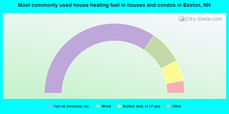
- 68.9%Fuel oil, kerosene, etc.
- 15.5%Wood
- 9.7%Bottled, tank, or LP gas
- 2.9%Coal or coke
- 2.9%Other fuel
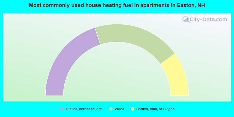
- 40.0%Fuel oil, kerosene, etc.
- 40.0%Wood
- 20.0%Bottled, tank, or LP gas
Easton compared to New Hampshire state average:
- Unemployed percentage below state average.
- Black race population percentage significantly below state average.
- Hispanic race population percentage significantly below state average.
- Median age significantly above state average.
- Foreign-born population percentage below state average.
- Renting percentage below state average.
- Length of stay since moving in significantly above state average.
- Number of rooms per house significantly below state average.
- House age significantly below state average.
- Percentage of population with a bachelor's degree or higher above state average.

|
Total of 1 patent application in 2008-2024.