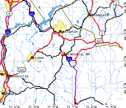
Franconia, New Hampshire
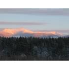
Franconia: White Mountain's Winter Majesty, Franconia Style. Franconia, NH

Franconia: Echo Lake
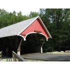
Franconia: covered bridge Franconia Notch State Park
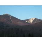
Franconia: The mountains of Franconia Notch Parkway
- add
your
Submit your own pictures of this town and show them to the world
- OSM Map
- General Map
- Google Map
- MSN Map
Population change since 2000: +19.5%
 |
| Males: 521 | |
| Females: 583 |
| Median resident age: | 53.9 years |
| New Hampshire median age: | 43.9 years |
Zip codes: 03580.
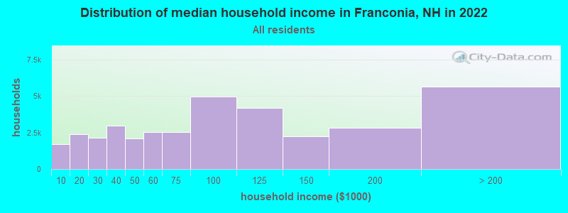
| Franconia: | $78,432 |
| NH: | $89,992 |
Estimated per capita income in 2022: $46,278 (it was $20,351 in 2000)
Franconia town income, earnings, and wages data
Estimated median house or condo value in 2022: $443,956 (it was $138,900 in 2000)
| Franconia: | $443,956 |
| NH: | $384,700 |
Mean prices in 2022: all housing units: $486,096; detached houses: $533,852; townhouses or other attached units: $375,744; in 2-unit structures: $230,260; in 3-to-4-unit structures: $242,363; in 5-or-more-unit structures: $588,257; mobile homes: $127,035
Detailed information about poverty and poor residents in Franconia, NH


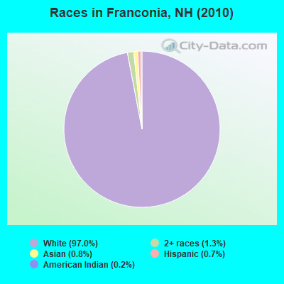
- 1,07197.0%White alone
- 141.3%Two or more races
- 90.8%Asian alone
- 80.7%Hispanic
- 20.2%American Indian alone
Races in Franconia detailed stats: ancestries, foreign born residents, place of birth
According to our research of New Hampshire and other state lists, there were 3 registered sex offenders living in Franconia, New Hampshire as of May 22, 2024.
The ratio of all residents to sex offenders in Franconia is 368 to 1.
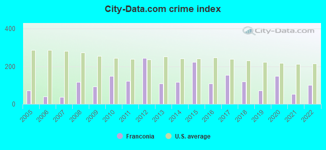
Type |
2009 |
2010 |
2011 |
2012 |
2013 |
2014 |
2015 |
2016 |
2017 |
2018 |
2019 |
2020 |
2021 |
2022 |
|---|---|---|---|---|---|---|---|---|---|---|---|---|---|---|
| Murders (per 100,000) | 0 (0.0) | 0 (0.0) | 0 (0.0) | 0 (0.0) | 0 (0.0) | 0 (0.0) | 0 (0.0) | 0 (0.0) | 0 (0.0) | 0 (0.0) | 0 (0.0) | 0 (0.0) | 0 (0.0) | 0 (0.0) |
| Rapes (per 100,000) | 0 (0.0) | 0 (0.0) | 0 (0.0) | 1 (90.6) | 0 (0.0) | 0 (0.0) | 1 (88.7) | 0 (0.0) | 1 (90.7) | 1 (90.8) | 0 (0.0) | 1 (90.5) | 0 (0.0) | 1 (90.8) |
| Robberies (per 100,000) | 0 (0.0) | 0 (0.0) | 0 (0.0) | 0 (0.0) | 0 (0.0) | 0 (0.0) | 0 (0.0) | 0 (0.0) | 0 (0.0) | 0 (0.0) | 0 (0.0) | 0 (0.0) | 0 (0.0) | 0 (0.0) |
| Assaults (per 100,000) | 0 (0.0) | 1 (90.6) | 0 (0.0) | 0 (0.0) | 1 (90.6) | 1 (89.8) | 3 (266.2) | 2 (178.6) | 0 (0.0) | 1 (90.8) | 1 (90.0) | 1 (90.5) | 0 (0.0) | 0 (0.0) |
| Burglaries (per 100,000) | 5 (472.1) | 4 (362.3) | 5 (452.5) | 11 (996.4) | 4 (362.3) | 1 (89.8) | 4 (354.9) | 2 (178.6) | 1 (90.7) | 1 (90.8) | 0 (0.0) | 2 (181.0) | 0 (0.0) | 1 (90.8) |
| Thefts (per 100,000) | 14 (1,322) | 29 (2,627) | 25 (2,262) | 26 (2,355) | 14 (1,268) | 24 (2,154) | 17 (1,508) | 17 (1,518) | 21 (1,906) | 6 (545.0) | 13 (1,170) | 13 (1,176) | 15 (1,343) | 6 (545.0) |
| Auto thefts (per 100,000) | 1 (94.4) | 0 (0.0) | 0 (0.0) | 1 (90.6) | 2 (181.2) | 1 (89.8) | 2 (177.5) | 0 (0.0) | 0 (0.0) | 0 (0.0) | 1 (90.0) | 0 (0.0) | 0 (0.0) | 0 (0.0) |
| Arson (per 100,000) | 0 (0.0) | 0 (0.0) | 0 (0.0) | 0 (0.0) | 0 (0.0) | 0 (0.0) | 0 (0.0) | 0 (0.0) | 0 (0.0) | 0 (0.0) | 1 (90.0) | 0 (0.0) | 0 (0.0) | 0 (0.0) |
| City-Data.com crime index | 93.5 | 148.6 | 122.2 | 243.7 | 108.7 | 117.6 | 223.6 | 108.9 | 155.2 | 119.0 | 72.0 | 150.2 | 53.7 | 100.8 |
The City-Data.com crime index weighs serious crimes and violent crimes more heavily. Higher means more crime, U.S. average is 246.1. It adjusts for the number of visitors and daily workers commuting into cities.
Crime rate in Franconia detailed stats: murders, rapes, robberies, assaults, burglaries, thefts, arson
Full-time law enforcement employees in 2021, including police officers: 4 (4 officers - 3 male; 1 female).
| Officers per 1,000 residents here: | 3.58 |
| New Hampshire average: | 2.14 |
 Recent articles from our blog. Our writers, many of them Ph.D. graduates or candidates, create easy-to-read articles on a wide variety of topics.

 | Possible Relocation to New Hampshire (30 replies) |
| Attractions near Twin Mountain NH (7 replies) |
| Franconia or Crawford Notch? (3 replies) |
| Thinking of moving to NH....no clue where (11 replies) |
| Am I missing something with Franconia? (4 replies) |
| Bethlehem Question (1 reply) |
Latest news from Franconia, NH collected exclusively by city-data.com from local newspapers, TV, and radio stations
Ancestries: English (39.2%), Irish (19.6%), Scottish (13.5%), German (12.1%), French (11.5%), Italian (7.4%).
Current Local Time: EST time zone
Incorporated in 1764
Elevation: 977 feet
Land area: 65.9 square miles.
Population density: 17 people per square mile (very low).
41 residents are foreign born (1.6% Asia, 1.4% Europe, 0.6% North America).
| This town: | 4.4% |
| New Hampshire: | 4.4% |
| Franconia town: | 1.9% ($2,684) |
| New Hampshire: | 2.3% ($2,946) |
Nearest city with pop. 50,000+: Portland, ME  (81.9 miles , pop. 64,249).
Nearest city with pop. 200,000+: Boston, MA (134.7 miles , pop. 589,141).
Nearest city with pop. 1,000,000+: Bronx, NY (257.3 miles , pop. 1,332,650).
Nearest cities:
), ), ), Latitude: 44.21 N, Longitude: 71.73 W
Area code: 603

Franconia tourist attractions:
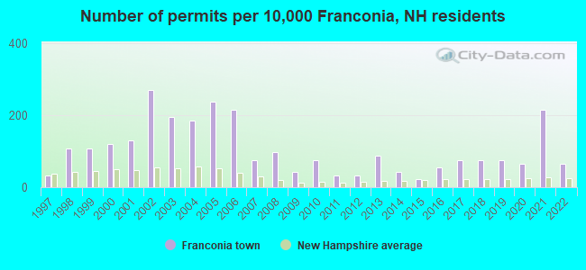
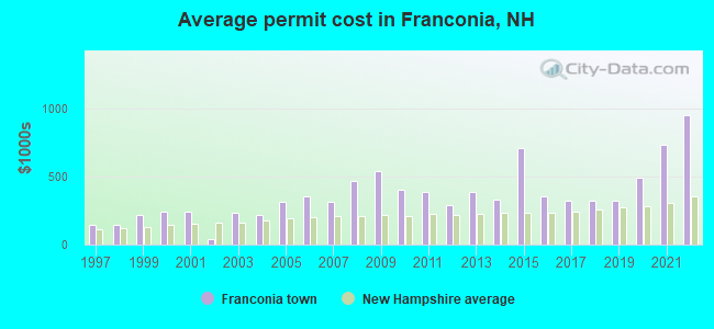
Single-family new house construction building permits:
- 2022: 6 buildings, average cost: $949,900
- 2021: 20 buildings, average cost: $733,100
- 2020: 6 buildings, average cost: $487,500
- 2019: 7 buildings, average cost: $324,300
- 2018: 7 buildings, average cost: $324,300
- 2017: 7 buildings, average cost: $324,300
- 2016: 5 buildings, average cost: $350,000
- 2015: 2 buildings, average cost: $706,500
- 2014: 4 buildings, average cost: $329,700
- 2013: 8 buildings, average cost: $383,600
- 2012: 3 buildings, average cost: $293,300
- 2011: 3 buildings, average cost: $386,700
- 2010: 7 buildings, average cost: $403,400
- 2009: 4 buildings, average cost: $537,500
- 2008: 9 buildings, average cost: $463,700
- 2007: 7 buildings, average cost: $311,400
- 2006: 20 buildings, average cost: $357,100
- 2005: 22 buildings, average cost: $310,700
- 2004: 17 buildings, average cost: $215,700
- 2003: 18 buildings, average cost: $233,300
- 2002: 25 buildings, average cost: $37,100
- 2001: 12 buildings, average cost: $244,100
- 2000: 11 buildings, average cost: $244,100
- 1999: 10 buildings, average cost: $214,100
- 1998: 10 buildings, average cost: $141,300
- 1997: 3 buildings, average cost: $148,300
| Here: | 1.8% |
| New Hampshire: | 2.5% |
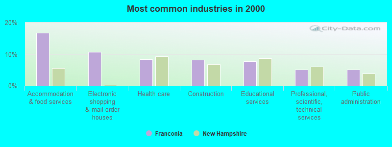
- Accommodation & food services (16.8%)
- Electronic shopping & mail-order houses (10.7%)
- Health care (8.4%)
- Construction (8.2%)
- Educational services (7.8%)
- Professional, scientific, technical services (5.0%)
- Public administration (5.0%)
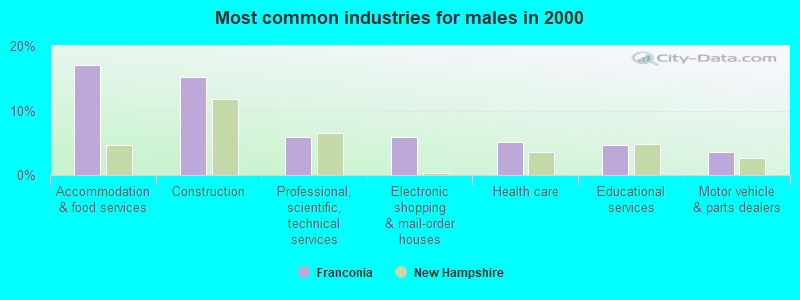
- Accommodation & food services (17.1%)
- Construction (15.2%)
- Professional, scientific, technical services (5.8%)
- Electronic shopping & mail-order houses (5.8%)
- Health care (5.1%)
- Educational services (4.7%)
- Motor vehicle & parts dealers (3.5%)
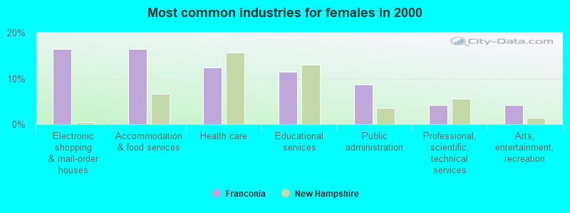
- Electronic shopping & mail-order houses (16.4%)
- Accommodation & food services (16.4%)
- Health care (12.3%)
- Educational services (11.4%)
- Public administration (8.7%)
- Professional, scientific, technical services (4.1%)
- Arts, entertainment, recreation (4.1%)
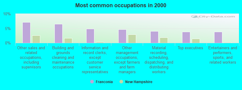
- Other sales and related occupations, including supervisors (7.1%)
- Building and grounds cleaning and maintenance occupations (6.5%)
- Information and record clerks, except customer service representatives (4.8%)
- Other management occupations, except farmers and farm managers (4.6%)
- Material recording, scheduling, dispatching, and distributing workers (4.0%)
- Top executives (3.8%)
- Entertainers and performers, sports, and related workers (3.8%)
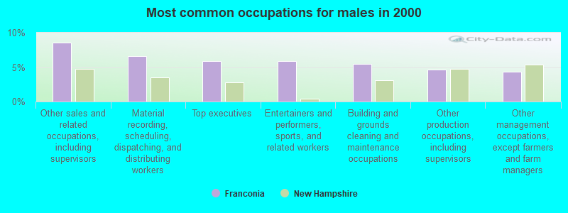
- Other sales and related occupations, including supervisors (8.6%)
- Material recording, scheduling, dispatching, and distributing workers (6.6%)
- Top executives (5.8%)
- Entertainers and performers, sports, and related workers (5.8%)
- Building and grounds cleaning and maintenance occupations (5.4%)
- Other production occupations, including supervisors (4.7%)
- Other management occupations, except farmers and farm managers (4.3%)
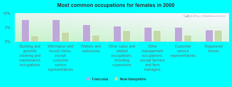
- Building and grounds cleaning and maintenance occupations (7.8%)
- Information and record clerks, except customer service representatives (7.8%)
- Waiters and waitresses (5.9%)
- Other sales and related occupations, including supervisors (5.5%)
- Other management occupations, except farmers and farm managers (5.0%)
- Customer service representatives (5.0%)
- Registered nurses (4.1%)
Average climate in Franconia, New Hampshire
Based on data reported by over 4,000 weather stations


(lower is better)
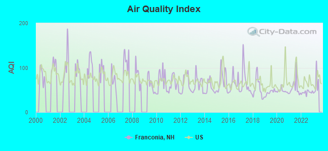
Air Quality Index (AQI) level in 2022 was 44.6. This is significantly better than average.
| City: | 44.6 |
| U.S.: | 72.6 |
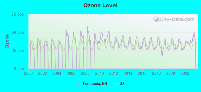
Ozone [ppb] level in 2022 was 35.4. This is about average. Closest monitor was 4.2 miles away from the city center.
| City: | 35.4 |
| U.S.: | 33.3 |
Earthquake activity:
Franconia-area historical earthquake activity is significantly above New Hampshire state average. It is 72% smaller than the overall U.S. average.On 4/20/2002 at 10:50:47, a magnitude 5.3 (5.3 ML, Depth: 3.0 mi, Class: Moderate, Intensity: VI - VII) earthquake occurred 99.6 miles away from Franconia center
On 4/20/2002 at 10:50:47, a magnitude 5.2 (5.2 MB, 4.2 MS, 5.2 MW, 5.0 MW) earthquake occurred 100.3 miles away from the city center
On 10/7/1983 at 10:18:46, a magnitude 5.3 (5.1 MB, 5.3 LG, 5.1 ML) earthquake occurred 131.2 miles away from Franconia center
On 1/19/1982 at 00:14:42, a magnitude 4.7 (4.5 MB, 4.7 MD, 4.5 LG, Class: Light, Intensity: IV - V) earthquake occurred 49.7 miles away from the city center
On 10/16/2012 at 23:12:25, a magnitude 4.7 (4.7 ML, Depth: 10.0 mi) earthquake occurred 68.2 miles away from the city center
On 6/16/1995 at 12:13:11, a magnitude 3.8 (3.8 LG, Depth: 3.1 mi, Class: Light, Intensity: II - III) earthquake occurred 10.6 miles away from the city center
Magnitude types: regional Lg-wave magnitude (LG), body-wave magnitude (MB), duration magnitude (MD), local magnitude (ML), surface-wave magnitude (MS), moment magnitude (MW)
Natural disasters:
The number of natural disasters in Grafton County (32) is a lot greater than the US average (15).Major Disasters (Presidential) Declared: 20
Emergencies Declared: 9
Causes of natural disasters: Floods: 16, Storms: 16, Hurricanes: 3, Snows: 3, Winter Storms: 3, Tropical Storms: 2, Blizzard: 1, Heavy Rain: 1, Ice Storm: 1, Landslide: 1, Snowfall: 1, Snowstorm: 1, Wind: 1, Other: 1 (Note: some incidents may be assigned to more than one category).

Hospitals and medical centers in Franconia:
Other hospitals and medical centers near Franconia:
Airports located in Franconia:
- Franconia Airport (1B5) (Runways: 1, Itinerant Ops: 200, Local Ops: 4,000)
- Presby Field Airport (25NH) (Runways: 1)
Colleges/universities with over 2000 students nearest to Franconia:
- Plymouth State University (about 32 miles; Plymouth, NH; Full-time enrollment: 4,838)
- Dartmouth College (about 46 miles; Hanover, NH; FT enrollment: 6,030)
- Norwich University (about 47 miles; Northfield, VT; FT enrollment: 4,221)
- Saint Joseph's College of Maine (about 68 miles; Standish, ME; FT enrollment: 2,010)
- NHTI-Concord's Community College (about 70 miles; Concord, NH; FT enrollment: 2,865)
- Middlebury College (about 74 miles; Middlebury, VT; FT enrollment: 3,077)
- Saint Michael's College (about 74 miles; Colchester, VT; FT enrollment: 2,336)
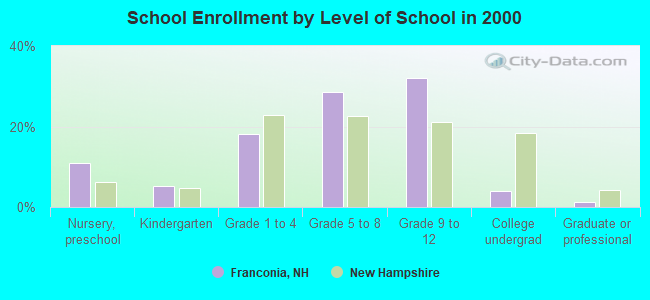
Public elementary/middle school in Franconia:
- LAFAYETTE REGIONAL SCHOOL (Students: 110, Location: 149 MAIN ST., Grades: KG-6)
Points of interest:
Notable locations in Franconia: Mittersill Alpine Resort (A), Coppermine Shelter WMNF (B), Galehead Hut (C), Cannon Mountain Aerial Passenger Tramway (D), Cannon Mountain Ski Area (E), Greenleaf Hut (F), Cannon Mountain Winter Sports Area (G), Eagle Lakes Hut (H), Cannon Mountain Aerial Tramway (I), Profile Golf Club (J), Thirteen Falls Campsite (K), Stone Iron Furnace Museum (L), Robert From Museum (M), Franconia Town Hall (N), Franconia-Sugar Hill-Easton Chamber of Commerce (O), Franconia Fire Department (P), Abbie Greenleaf Memorial Library (Q), Franconia Life Squad (R). Display/hide their locations on the map
Churches in Franconia include: Community Church of Christ (A), Our Lady of the Snows Roman Catholic Church (B). Display/hide their locations on the map
Cemeteries: Willow Cemetery (1), Elmwood Cemetery (2). Display/hide their locations on the map
Lakes and reservoirs: Profile Lake (A), Echo Lake (B), Eagles Lakes (C), Garfield Pond (D), Bethlehem Reservoir (E). Display/hide their locations on the map
Streams, rivers, and creeks: Wiseman Brook (A), Hellgate Brook (B), Ham Branch (C), Meadow Brook (D), Redrock Brook (E), Coppermine Brook (F), Burnt Brook (G), Bowen Brook (H), Beaver Brook (I). Display/hide their locations on the map
Park in Franconia: Franconia Notch State Park (1). Display/hide its location on the map
Tourist attraction: Franconia Heritage Museum (553 Main) (1). Display/hide its approximate location on the map
Hotels: 1784-Lovett's Inn (1474 Profile Rd) (1), Franconia Inn (Easton Road) (2), Pinestead Farm Lodge (2059 Easton Road) (3), Franconia Village Hotel (87 Wallace Hill Rd) (4), Cannon Mountain View Motel (729 Main St) (5), Gale River Motel (1 Main Street) (6), Mittersill Alpine Inn (Route 18) (7), Westwind Vacation Cottages (Profile Rd.) (8). Display/hide their approximate locations on the map
Drinking water stations with addresses in Franconia and their reported violations in the past:
MITTERSILL WATER DEPT (Population served: 475, Groundwater):Past health violations:FRANCONIA VILLAGE WATER (Population served: 427, Groundwater):Past monitoring violations:
- MCL, Monthly (TCR) - In SEP-2013, Contaminant: Coliform. Follow-up actions: St Public Notif requested (SEP-05-2013), St Violation/Reminder Notice (SEP-05-2013), St Public Notif received (SEP-12-2013), St Compliance achieved (APR-10-2014)
- MCL, Monthly (TCR) - In AUG-2013, Contaminant: Coliform. Follow-up actions: St Public Notif requested (SEP-03-2013), St Violation/Reminder Notice (SEP-03-2013), St Public Notif received (SEP-06-2013), St Compliance achieved (APR-10-2014)
- Monitoring, Source Water (GWR) - Between SEP-07-2013 and OCT-07-2013, Contaminant: E. COLI. Follow-up actions: St Public Notif requested (OCT-22-2013), St Violation/Reminder Notice (OCT-22-2013), St Compliance achieved (OCT-24-2013), St Public Notif received (OCT-29-2013)
- Follow-up Or Routine LCR Tap M/R - In OCT-01-2008, Contaminant: Lead and Copper Rule. Follow-up actions: St Public Notif requested (NOV-07-2008), St Violation/Reminder Notice (NOV-07-2008), St Compliance achieved (NOV-22-2008), St Public Notif received (DEC-01-2008)
- One routine major monitoring violation
- 30 regular monitoring violations
Past health violations:PROFILE CLUB GOLF COURSE (Population served: 50, Groundwater):Past monitoring violations:
- Public Education - In NOV-26-2012, Contaminant: Lead and Copper Rule. Follow-up actions: St Violation/Reminder Notice (DEC-05-2012), St Compliance achieved (DEC-07-2012)
- Public Education - In DEC-11-2010, Contaminant: Lead and Copper Rule. Follow-up actions: St Public Notif requested (JAN-14-2011), St Violation/Reminder Notice (JAN-14-2011), St Public Notif received (JAN-24-2011), St Compliance achieved (JAN-24-2011)
- Follow-up Or Routine LCR Tap M/R - In JAN-01-2012, Contaminant: Lead and Copper Rule. Follow-up actions: St Public Notif requested (AUG-13-2012), St Violation/Reminder Notice (AUG-13-2012), St Compliance achieved (SEP-03-2012), St Public Notif received (OCT-01-2012)
- One routine major monitoring violation
Past monitoring violations:
- 4 routine major monitoring violations
| This town: | 2.1 people |
| New Hampshire: | 2.5 people |
| This town: | 63.2% |
| Whole state: | 66.3% |
| This town: | 7.0% |
| Whole state: | 8.3% |
Likely homosexual households (counted as self-reported same-sex unmarried-partner households)
- Lesbian couples: 0.6% of all households
- Gay men: 0.2% of all households
| This town: | 8.9% |
| Whole state: | 6.5% |
| This town: | 1.8% |
| Whole state: | 2.8% |
9 people in emergency and transitional shelters (with sleeping facilities) for people experiencing homelessness in 2010
69 people in nursing homes in 2000
Banks with branches in Franconia (2011 data):
- Woodsville Guaranty Savings Bank: Franconia Branch at 278 Main Street, branch established on 2007/05/30. Info updated 2006/10/31: Bank assets: $393.0 mil, Deposits: $296.3 mil, headquarters in Woodsville, NH, positive income, Commercial Lending Specialization, 9 total offices, Holding Company: Guaranty Bancorp, Inc.
- Connecticut River Bank, National Association: Franconia Branch at Kelly's Foodtown, 347 Main Street, branch established on 2000/07/01. Info updated 2008/07/16: Bank assets: $267.5 mil, Deposits: $242.4 mil, headquarters in Springfield, VT, positive income, Commercial Lending Specialization, 11 total offices, Holding Company: Connecticut River Bancorp, Inc.
For population 15 years and over in Franconia:
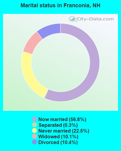
- Never married: 22.5%
- Now married: 56.8%
- Separated: 0.3%
- Widowed: 10.1%
- Divorced: 10.4%
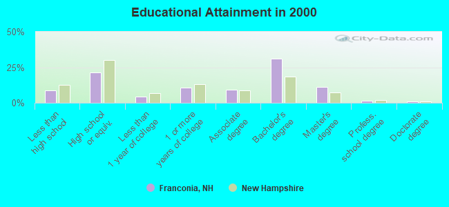
For population 25 years and over in Franconia:
- High school or higher: 91.1%
- Bachelor's degree or higher: 45.0%
- Graduate or professional degree: 13.8%
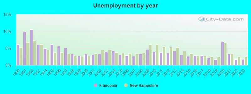
- Unemployed: 3.3%
- Mean travel time to work (commute): 16.9 minutes
| Here: | 9.7 |
| New Hampshire average: | 10.9 |


Graphs represent county-level data. Detailed 2008 Election Results
Religion statistics for Franconia, NH (based on Grafton County data)


| Religion | Adherents | Congregations |
|---|---|---|
| Catholic | 9,503 | 12 |
| Mainline Protestant | 7,832 | 57 |
| Evangelical Protestant | 1,494 | 29 |
| Other | 1,320 | 11 |
| None | 68,969 | - |
Food Environment Statistics:
| Grafton County: | 3.87 / 10,000 pop. |
| New Hampshire: | 2.14 / 10,000 pop. |
| This county: | 0.23 / 10,000 pop. |
| New Hampshire: | 0.15 / 10,000 pop. |
| Grafton County: | 1.29 / 10,000 pop. |
| New Hampshire: | 1.78 / 10,000 pop. |
| This county: | 6.45 / 10,000 pop. |
| New Hampshire: | 4.02 / 10,000 pop. |
| This county: | 14.41 / 10,000 pop. |
| State: | 9.70 / 10,000 pop. |
| Grafton County: | 7.2% |
| State: | 7.6% |
| Grafton County: | 22.9% |
| New Hampshire: | 24.4% |
| Grafton County: | 15.9% |
| State: | 15.9% |
| Businesses in Franconia, NH | ||||
| Name | Count | Name | Count | |
|---|---|---|---|---|
| Best Western | 1 | True Value | 1 | |
| FedEx | 1 | UPS | 2 | |
Strongest AM radio stations in Franconia:
- WTWN (1100 AM; daytime; 5 kW; WELLS RIVER, VT; Owner: PUFFER BROADCASTING, INC.)
- WLTN (1400 AM; 1 kW; LITTLETON, NH; Owner: PROFILE BROADCASTING COMPANY, INC.)
- WRKO (680 AM; 50 kW; BOSTON, MA; Owner: ENTERCOM BOSTON LICENSE, LLC)
- WCHP (760 AM; 35 kW; CHAMPLAIN, NY; Owner: CHAMPLAIN RADIO, INC.)
- WPNH (1300 AM; 5 kW; PLYMOUTH, NH; Owner: NORTHEAST COMMUNICATIONS CORPORATION)
- WNNZ (640 AM; 50 kW; WESTFIELD, MA; Owner: CLEAR CHANNEL BROADCASTING LICENSES, INC.)
- WCRN (830 AM; 50 kW; WORCESTER, MA; Owner: CARTER BROADCASTING CORPORATION)
- WDEV (550 AM; 5 kW; WATERBURY, VT; Owner: RADIO VERMONT, INC.)
- WEEI (850 AM; 50 kW; BOSTON, MA; Owner: ENTERCOM BOSTON LICENSE, LLC)
- WTME (780 AM; 10 kW; RUMFORD, ME; Owner: MOUNTAIN VALLEY BROADCASTING, INC.)
- WGY (810 AM; 50 kW; SCHENECTADY, NY; Owner: CLEAR CHANNEL BROADCASTING LICENSES, INC.)
- WNTK (1020 AM; 10 kW; NEWPORT, NH; Owner: KOOR COMMUNICATIONS, INC.)
- WBZ (1030 AM; 50 kW; BOSTON, MA; Owner: INFINITY BROADCASTING OPERATIONS, INC.)
Strongest FM radio stations in Franconia:
- WPKQ (103.7 FM; NORTH CONWAY, NH; Owner: CITADEL BROADCASTING COMPANY)
- WHOM (94.9 FM; MT. WASHINGTON, NH; Owner: CITADEL BROADCASTING COMPANY)
- WMTK (106.3 FM; LITTLETON, NH; Owner: VERMONT BROADCAST ASSOCIATES, INC.)
- WLTN-FM (96.7 FM; LISBON, NH; Owner: PROFILE BROADCASTING CO., INC.)
- WVFM (105.7 FM; CAMPTON, NH; Owner: DEVON BROADCASTING COMPANY, INC.)
- WXXS (102.3 FM; LANCASTER, NH; Owner: BARRY P. LUNDERVILLE)
- WGMT (97.7 FM; LYNDON, VT; Owner: VERMONT BROADCAST ASSOCIATES, INC.)
- WSCY (106.9 FM; MOULTONBOROUGH, NH; Owner: NORTHEAST COMMUNICATIONS CORPORATION)
- WCKJ (90.5 FM; ST. JOHNSBURY, VT; Owner: CHRISTIAN MINISTRIES, INC.)
- WKXH (105.5 FM; ST. JOHNSBURY, VT; Owner: VERMONT BROADCAST ASSOCIATES, INC.)
- WDOT (95.7 FM; DANVILLE, VT; Owner: MONTPELIER BROADCASTING INC)
- WCVT (101.7 FM; STOWE, VT; Owner: RADIO VERMONT CLASSICS, L.L.C.)
- WLKC (103.3 FM; WATERBURY, VT; Owner: RADIO BROADCASTING SERVICES, INC.)
- WPNH-FM (100.1 FM; PLYMOUTH, NH; Owner: NORTHEAST COMMUNICATIONS CORPORATION)
- WVPS (107.9 FM; BURLINGTON, VT; Owner: VERMONT PUBLIC RADIO)
- WEZF (92.9 FM; BURLINGTON, VT; Owner: CAPSTAR TX LIMITED PARTNERSHIP)
- WDEV-FM (96.1 FM; WARREN, VT; Owner: RADIO VERMONT, INC.)
- WNCS (104.7 FM; MONTPELIER, VT; Owner: MONTPELIER BROADCASTING, INC.)
- WYKR-FM (101.3 FM; HAVERHILL, NH; Owner: PUFFER BROADCASTING, INC.)
- WEBK (105.3 FM; KILLINGTON, VT; Owner: 6 JOHNSON ROAD LICENSES, INC.)
TV broadcast stations around Franconia:
- WLED-TV (Channel 49; LITTLETON, NH; Owner: UNIVERSITY OF NEW HAMPSHIRE)
- WMUR-LP (Channel 29; LITTLETON, NH; Owner: HEARST-ARGYLE PROPERTIES, INC.)
- W38CB (Channel 38; LITTLETON, NH; Owner: HEARST-ARGYLE PROPERTIES, INC.)
- WMTW-TV (Channel 8; POLAND SPRING, ME; Owner: WMTW BROADCAST GROUP, LLC)
- Franconia, New Hampshire
- Fatal accident count24
- Vehicles involved in fatal accidents33
- Fatal accidents involving drunk persons:5
- Fatalities29
- Persons involved in fatal accidents55
- Pedestrians involved in fatal accidents0
- New Hampshire average
- Fatal accident count2490
- Vehicles involved in fatal accidents3578
- Fatal accidents involving drunk persons1105
- Fatalities2708
- Persons involved in fatal accidents5865
- Pedestrians involved in fatal accidents163
- National Bridge Inventory (NBI) Statistics
- 26Number of bridges
- 282ft / 86.3mTotal length
- $75,408,000Total costs
- 71,372Total average daily traffic
- 6,089Total average daily truck traffic
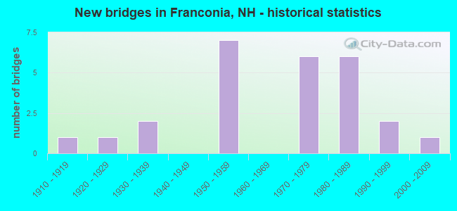
- New bridges - historical statistics
- 11910-1919
- 11920-1929
- 21930-1939
- 71950-1959
- 61970-1979
- 61980-1989
- 21990-1999
- 12000-2009
FCC Registered Antenna Towers:
5- PERRY S WILLIAMS, 1643 Profile Road (Lat: 44.200972 Lon: -71.719222), Type: 15.0, Structure height: 33009 m, Overall height: 15 m, Registrant: Perry Williams 158 Quebec Road Lyman Nh 03585, Perrywilliams@earthlink.Net, , Lyman, Phone: (603) 838-6896
- Perry Williams, 1643 Profile Road (Lat: 44.200889 Lon: -71.718556), Type: 13.0, Structure height: 33009 m, Overall height: 13 m, Registrant: Perrywilliams@earthlink.Net, , Lyman, Phone: (603) 838-6896
- Perry S Williams, 1643 Profile Road (Lat: 44.200889 Lon: -71.718556), Type: 13.0, Structure height: 33009 m, Overall height: 13 m, Registrant: Perrywilliams@earthlink.Net, , Lyman, Phone: (603) 838-6896
- Perry Williams, 1643 Profile Road (Lat: 44.200889 Lon: -71.718556), Type: 13.0, Structure height: 33009 m, Overall height: 13 m, Registrant: Perrywilliams@earthlink.Net, , Lyman, Phone: (603) 838-6896
- Perry Williams, 1643 Profile Road (Lat: 44.200889 Lon: -71.718556), Type: 13.0, Structure height: 33009 m, Overall height: 13 m, Registrant: Perrywilliams@earthlink.Net, , Lyman, Phone: (603) 838-6896
FCC Registered Broadcast Land Mobile Towers:
7- Fire Station Rt 18 (Lat: 44.221722 Lon: -71.734528), Type: Bant, Structure height: 18 m, Overall height: 24 m, Call Sign: KNGG386, Licensee ID: L00071708,
Assigned Frequencies: 154.400 MHz, Grant Date: 05/01/2013, Expiration Date: 05/04/2023, Cancellation Date: 07/15/2023, Registrant: Franconia, Town Of, Franconia, NH 03580, Phone: (603) 823-8821
- 840 Easton Road (Lat: 44.205000 Lon: -71.753333), Type: Bant, Structure height: 6 m, Overall height: 9 m, Call Sign: KAQ977,
Assigned Frequencies: 154.965 MHz, Grant Date: 07/28/2021, Expiration Date: 09/27/2031, Registrant: 816 Profile Rd, Franconia, NH 03580, Phone: (603) 823-7025, Email:
- Hwy Patrol 124 (Lat: 44.204500 Lon: -71.709528), Call Sign: WBC275, Licensee ID: L00307774,
Assigned Frequencies: 458.925 MHz, 458.975 MHz, Grant Date: 04/28/2015, Expiration Date: 05/21/2025, Registrant: State Of New Hampshire, Department Of Transportation, Division Of Operations, Seven Hazen Drive, Concord, NH 03302-0483, Phone: (603) 271-6862, Fax: (603) 271-8626
- Cannon Mountain Fire Tower (Lat: 44.157000 Lon: -71.698417), Call Sign: KCA453,
Assigned Frequencies: 48.1200 MHz, 48.4200 MHz, 48.4800 MHz, Grant Date: 08/06/2022, Expiration Date: 09/23/2032, Registrant: Utilities Technology Council, 2550 South Clark St., Suite 960, Arlington, VA 22202, Phone: (202) 833-6818, Fax: (202) 872-1331, Email:
- Lat: 44.214083 Lon: -71.737556, Call Sign: WQCM994,
Assigned Frequencies: 159.645 MHz, 159.645 MHz, Grant Date: 04/12/2005, Expiration Date: 04/12/2015, Cancellation Date: 06/13/2015, Certifier: John L Taylor, Registrant: Business Radio Licensing, 26941 Cabot Road #134, Laguna Hills, CA 92653, Phone: (949) 348-8510, Email:
- Lat: 44.214083 Lon: -71.737556, Call Sign: WQRP456, Licensee ID: L01759703,
Assigned Frequencies: 159.645 MHz, Grant Date: 07/01/2013, Expiration Date: 07/01/2023, Cancellation Date: 09/02/2023, Certifier: Gregg Weiskerger, Registrant: Weiskerger Campground Operations LLC, 974 Profile Rd, Franconia, NH 03580, Phone: (603) 823-5675, Fax: (603) 823-5676, Email:
- Lat: 44.205306 Lon: -71.691583, Call Sign: WRYD537,
Assigned Frequencies: 462.212 MHz, 467.212 MHz, 462.387 MHz, 467.387 MHz, Grant Date: 07/27/2023, Expiration Date: 07/27/2033, Certifier: Matt Fiorentino, Registrant: Cara Enterprises, Inc., Las Vegas, NV 89140, Phone: (702) 838-9728, Fax: (702) 363-4607, Email:
FCC Registered Microwave Towers:
17 (See the full list of FCC Registered Microwave Towers in this town)FCC Registered Paging Towers:
1 (See the full list of FCC Registered Paging Towers)FCC Registered Maritime Coast & Aviation Ground Towers:
1 (See the full list of FCC Registered Maritime Coast & Aviation Ground Towers)FCC Registered Amateur Radio Licenses:
23 (See the full list of FCC Registered Amateur Radio Licenses in Franconia)FAA Registered Aircraft:
12 (See the full list of FAA Registered Aircraft in Franconia)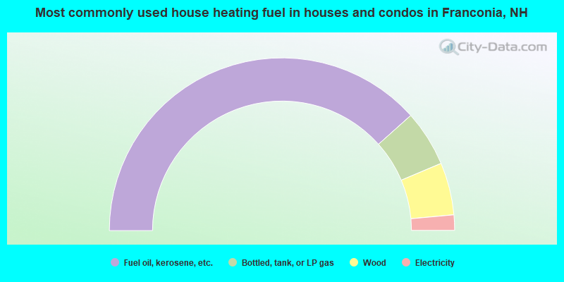
- 76.8%Fuel oil, kerosene, etc.
- 10.5%Bottled, tank, or LP gas
- 9.8%Wood
- 2.9%Electricity
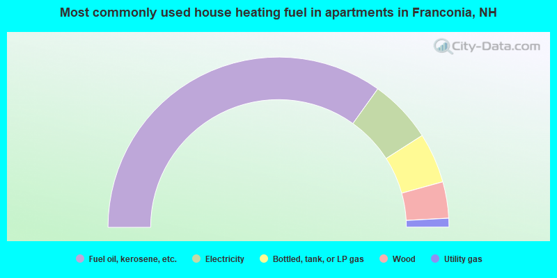
- 69.8%Fuel oil, kerosene, etc.
- 12.1%Electricity
- 9.5%Bottled, tank, or LP gas
- 6.9%Wood
- 1.7%Utility gas
Franconia compared to New Hampshire state average:
- Unemployed percentage significantly below state average.
- Black race population percentage significantly below state average.
- Hispanic race population percentage significantly below state average.
- Median age significantly above state average.
- Length of stay since moving in significantly above state average.
- Number of rooms per house significantly below state average.
- House age significantly below state average.
- Institutionalized population percentage significantly above state average.
- Number of college students significantly below state average.

|
|
Total of 16 patent applications in 2008-2024.