Echo, Alabama
Submit your own pictures of this place and show them to the world
- OSM Map
- General Map
- Google Map
- MSN Map

| Males: 1,014 | |
| Females: 1,045 |
| Median resident age: | 39.4 years |
| Alabama median age: | 35.8 years |
Zip code: 36360
| Echo: | $57,601 |
| AL: | $59,674 |
Estimated per capita income in 2022: $27,917 (it was $15,584 in 2000)
Echo CCD income, earnings, and wages data
Estimated median house or condo value in 2022: $115,236 (it was $52,200 in 2000)
| Echo: | $115,236 |
| AL: | $200,900 |
Detailed information about poverty and poor residents in Echo, AL
Compare current foreclosures near Echo, AL:
| Photo | Address | Area | Beds / Baths | Price | Details |
|---|---|---|---|---|---|

|
#1
Newton Ave
Ozark, AL 36360
|
2,135 sq. feet
|
1 baths 3 beds |
show details | |

|
#2
Joseph Dr
Ozark, AL 36360
|
1,856 sq. feet
|
1 baths 3 beds |
show details | |

|
#3
S College St
Newton, AL 36352
|
1,594 sq. feet
|
1 baths 2 beds |
show details | |

|
#4
Cornell Ave
Dothan, AL 36303
|
1,757 sq. feet
|
2 baths 3 beds |
show details | |

|
#5
Ronald Ln
Dothan, AL 36303
|
1,375 sq. feet
|
1 baths 2 beds |
show details | |

|
#6
Fairmont St
Dothan, AL 36303
|
1,769 sq. feet
|
2 baths 3 beds |
show details | |

|
#7
Charlton Dr
Dothan, AL 36303
|
1,456 sq. feet
|
2 baths 3 beds |
show details | |

|
#8
Wentworth Dr
Dothan, AL 36305
|
2,642 sq. feet
|
2 baths 4 beds |
show details | |

|
#9
Montezuma Ave
Dothan, AL 36303
|
1,615 sq. feet
|
2 baths 3 beds |
show details | |

|
#10
Headland Ave
Dothan, AL 36303
|
1,670 sq. feet
|
2 baths 3 beds |
show details |
| Photo | Address | Area | Beds / Baths | Price | Details |
|---|---|---|---|---|---|

|
#11
Verde Trl
Dothan, AL 36303
|
1,816 sq. feet
|
2 baths 3 beds |
show details | |

|
#12
Vining Dr
Dothan, AL 36303
|
1,717 sq. feet
|
2 baths 3 beds |
show details | |

|
#13
Caravan Ln
Dothan, AL 36303
|
1,601 sq. feet
|
2 baths 3 beds |
show details | |

|
#14
Rosedale Ter
Dothan, AL 36303
|
2,121 sq. feet
|
2 baths 3 beds |
show details | |

|
#15
Sawgrass Dr
Dothan, AL 36303
|
2,645 sq. feet
|
3 baths 4 beds |
show details | |

|
#16
Shadowlawn Dr
Dothan, AL 36303
|
1,811 sq. feet
|
2 baths 3 beds |
show details | |

|
#17
Sanders Rd
Dothan, AL 36303
|
1,400 sq. feet
|
2 baths 3 beds |
show details | |

|
#18
Lingo Rd
Dothan, AL 36303
|
1,440 sq. feet
|
1 baths 2 beds |
show details | |

|
#19
Thorndale Pl
Dothan, AL 36303
|
1,636 sq. feet
|
2 baths 3 beds |
show details | |

|
#20
Kristi Lea Dr
Dothan, AL 36303
|
1,668 sq. feet
|
2 baths 3 beds |
show details |
| Photo | Address | Area | Beds / Baths | Price | Details |
|---|---|---|---|---|---|

|
#21
Rock Spring Rd
Dothan, AL 36303
|
1,404 sq. feet
|
2 baths 3 beds |
show details | |

|
#22
Peachtree Dr
Dothan, AL 36303
|
2,219 sq. feet
|
3 baths 3 beds |
show details | |

|
#23
Kristi Lea Dr
Dothan, AL 36303
|
1,056 sq. feet
|
1 baths 3 beds |
show details | |

|
#24
Richland Rd
Dothan, AL 36303
|
1,617 sq. feet
|
2 baths 3 beds |
show details | |

|
#25
Crichton Ct
Dothan, AL 36305
|
2,792 sq. feet
|
2 baths 4 beds |
show details | |

|
#26
Sundance Ln
Midland City, AL 36350
|
1,226 sq. feet
|
2 baths 3 beds |
show details | |

|
#27
Chinook St
Dothan, AL 36303
|
1,025 sq. feet
|
1 baths 3 beds |
show details | |

|
#28
Sundance Ln
Midland City, AL 36350
|
1,507 sq. feet
|
2 baths 3 beds |
show details | |

|
#29
Candle Brook Dr
Dothan, AL 36303
|
1,423 sq. feet
|
2 baths 3 beds |
show details | |

|
#30
E Columbia Rd
Newville, AL 36353
|
1,296 sq. feet
|
1 baths - beds |
show details |
| Photo | Address | Area | Beds / Baths | Price | Details |
|---|---|---|---|---|---|

|
#31
E Alabama St
Abbeville, AL 36310
|
1,375 sq. feet
|
1 baths - beds |
show details | |

|
#32
Balfour Dr
Dothan, AL 36303
|
1,171 sq. feet
|
1 baths - beds |
show details | |

|
#33
Monte Carlo Dr # 4
Dothan, AL 36303
|
1,779 sq. feet
|
1 baths - beds |
show details | |

|
#34
Azure Dr
Dothan, AL 36303
|
1,846 sq. feet
|
1 baths - beds |
show details | |

|
#35
Randall Rd
Dothan, AL 36303
|
1,500 sq. feet
|
1 baths - beds |
show details | |

|
#36
Ross Ln
Headland, AL 36345
|
1,729 sq. feet
|
1 baths - beds |
show details | |

|
#37
Selkirk Dr
Dothan, AL 36303
|
1,876 sq. feet
|
1 baths - beds |
show details | |

|
#38
Keating Rd
Dothan, AL 36303
|
1,537 sq. feet
|
1 baths - beds |
show details | |

|
#39
Granada Dr
Dothan, AL 36303
|
2,126 sq. feet
|
1 baths - beds |
show details | |

|
#40
Silverado Dr
Dothan, AL 36303
|
1,025 sq. feet
|
1 baths - beds |
show details |
| Photo | Address | Area | Beds / Baths | Price | Details |
|---|---|---|---|---|---|

|
#41
Denton Rd
Dothan, AL 36303
|
2,177 sq. feet
|
1 baths - beds |
show details | |

|
#42
Tarboro St
Dothan, AL 36303
|
2,088 sq. feet
|
1 baths - beds |
show details | |

|
#43
Silverado Dr
Dothan, AL 36303
|
1,025 sq. feet
|
1 baths - beds |
show details | |

|
#44
Dothan Rd
Abbeville, AL 36310
|
2,770 sq. feet
|
1 baths - beds |
show details | |

|
#45
Briarhill Rd
Dothan, AL 36303
|
1,051 sq. feet
|
1 baths - beds |
show details | |

|
#46
County Road 45 S
Headland, AL 36345
|
2,921 sq. feet
|
1 baths - beds |
show details | |

|
#47
Alberta Dr
Abbeville, AL 36310
|
1,134 sq. feet
|
1 baths - beds |
show details | |

|
#48
Fleetside Ct
Dothan, AL 36303
|
1,278 sq. feet
|
1 baths - beds |
show details | |

|
#49
Copper Ct
Midland City, AL 36350
|
1,389 sq. feet
|
1 baths - beds |
show details | |

|
Check over 1 million property listings on Foreclosure.com!
|
browse all offers | |||

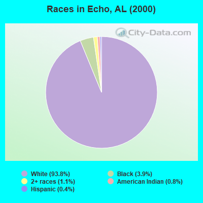
- 1,96493.8%White alone
- 813.9%Black alone
- 221.1%Two or more races
- 160.8%American Indian alone
- 90.4%Hispanic
- 20.10%Asian alone
 Recent articles from our blog. Our writers, many of them Ph.D. graduates or candidates, create easy-to-read articles on a wide variety of topics.

Current Local Time: CST time zone
Elevation: 454 feet
Land area: 95.4 square miles.
Population density: 22 people per square mile (very low).

| Echo CCD: | 0.4% ($199) |
| Alabama: | 0.4% ($289) |
Nearest city with pop. 50,000+: Dothan, AL  (17.7 miles , pop. 57,737).
Nearest city with pop. 200,000+: Montgomery, AL (77.4 miles , pop. 201,568).
Nearest city with pop. 1,000,000+: Houston, TX (601.7 miles , pop. 1,953,631).
Nearest cities:
), ), ), ), )Latitude: 31.48 N, Longitude: 85.47 W
Area code: 334

| Here: | 2.8% |
| Alabama: | 2.6% |
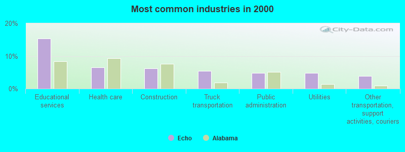
- Educational services (15.4%)
- Health care (6.5%)
- Construction (6.1%)
- Truck transportation (5.5%)
- Public administration (4.9%)
- Utilities (4.8%)
- Other transportation, support activities, couriers (3.9%)
- Educational services (11.0%)
- Construction (10.7%)
- Truck transportation (8.1%)
- Utilities (6.3%)
- Other transportation, support activities, couriers (5.7%)
- Public administration (5.2%)
- Plastics & rubber products (5.2%)

- Educational services (21.3%)
- Health care (13.4%)
- Apparel (8.2%)
- Personal & laundry services (7.4%)
- Social assistance (5.7%)
- Public administration (4.5%)
- Professional, scientific, technical services (4.0%)
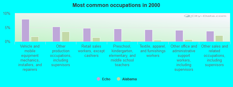
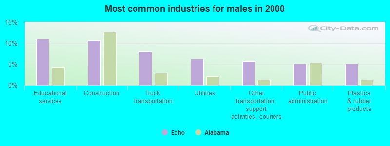
- Vehicle and mobile equipment mechanics, installers, and repairers (7.9%)
- Other production occupations, including supervisors (5.3%)
- Retail sales workers, except cashiers (4.8%)
- Preschool, kindergarten, elementary, and middle school teachers (4.5%)
- Textile, apparel, and furnishings workers (4.2%)
- Other office and administrative support workers, including supervisors (4.0%)
- Other sales and related occupations, including supervisors (3.7%)
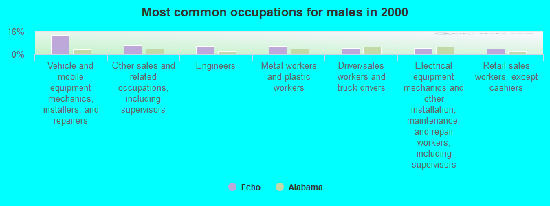
- Vehicle and mobile equipment mechanics, installers, and repairers (13.8%)
- Other sales and related occupations, including supervisors (6.4%)
- Engineers (5.7%)
- Metal workers and plastic workers (5.7%)
- Driver/sales workers and truck drivers (4.4%)
- Electrical equipment mechanics and other installation, maintenance, and repair workers, including supervisors (4.2%)
- Retail sales workers, except cashiers (3.9%)

- Textile, apparel, and furnishings workers (9.9%)
- Secretaries and administrative assistants (8.2%)
- Other production occupations, including supervisors (7.2%)
- Preschool, kindergarten, elementary, and middle school teachers (6.7%)
- Retail sales workers, except cashiers (5.9%)
- Other teachers, instructors, education, training, and library occupations (5.2%)
- Information and record clerks, except customer service representatives (5.0%)
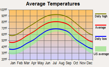
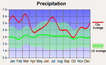
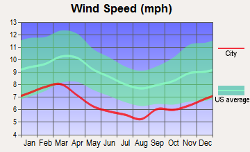
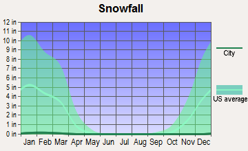
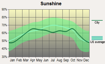
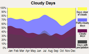
Average climate in Echo, Alabama
Based on data reported by over 4,000 weather stations

(lower is better)
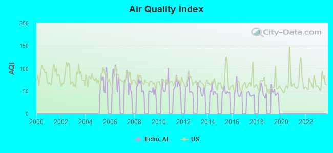
Air Quality Index (AQI) level in 2019 was 47.9. This is significantly better than average.
| City: | 47.9 |
| U.S.: | 72.6 |
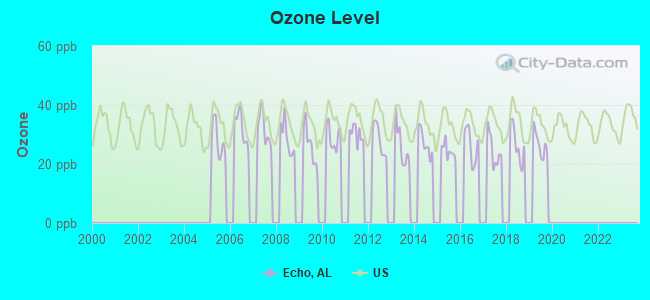
Ozone [ppb] level in 2019 was 26.7. This is better than average. Closest monitor was 20.2 miles away from the city center.
| City: | 26.7 |
| U.S.: | 33.3 |
Tornado activity:
Echo-area historical tornado activity is slightly below Alabama state average. It is 52% greater than the overall U.S. average.
On 3/1/2007, a category F4 (max. wind speeds 207-260 mph) tornado 30.0 miles away from the Echo place center killed 9 people and injured 50 people and caused $250 million in damages.
On 1/13/1972, a category F3 (max. wind speeds 158-206 mph) tornado 9.4 miles away from the place center injured 2 people and caused between $50,000 and $500,000 in damages.
Earthquake activity:
Echo-area historical earthquake activity is significantly above Alabama state average. It is 15% greater than the overall U.S. average.On 10/24/1997 at 08:35:17, a magnitude 4.9 (4.8 MB, 4.2 MS, 4.9 LG, Depth: 6.2 mi, Class: Light, Intensity: IV - V) earthquake occurred 109.4 miles away from Echo center
On 1/18/1999 at 07:00:53, a magnitude 4.8 (4.8 MB, 4.0 LG, Depth: 0.6 mi) earthquake occurred 169.2 miles away from the city center
On 4/29/2003 at 08:59:39, a magnitude 4.9 (4.4 MB, 4.6 MW, 4.9 LG) earthquake occurred 208.8 miles away from the city center
On 8/2/1974 at 08:52:09, a magnitude 4.9 (4.3 MB, 4.9 LG) earthquake occurred 239.8 miles away from the city center
On 4/29/2003 at 08:59:39, a magnitude 4.6 (4.6 MW, Depth: 12.3 mi) earthquake occurred 208.8 miles away from the city center
On 11/7/2004 at 11:20:21, a magnitude 4.3 (4.3 MW, Depth: 3.1 mi) earthquake occurred 165.6 miles away from Echo center
Magnitude types: regional Lg-wave magnitude (LG), body-wave magnitude (MB), surface-wave magnitude (MS), moment magnitude (MW)
Natural disasters:
The number of natural disasters in Dale County (24) is greater than the US average (15).Major Disasters (Presidential) Declared: 17
Emergencies Declared: 5
Causes of natural disasters: Storms: 14, Tornadoes: 10, Floods: 9, Hurricanes: 6, Winds: 4, Drought: 1, Snowfall: 1, Tropical Storm: 1, Winter Storm: 1, Other: 1 (Note: some incidents may be assigned to more than one category).
Hospitals and medical centers near Echo:
- COMMUNITY HOSPICE OF DALE MEDICAL CENTER (Hospital, about 10 miles away; OZARK, AL)
- DALE MEDICAL CTR HOME HEALTH (Home Health Center, about 10 miles away; OZARK, AL)
- DALE MEDICAL CENTER Acute Care Hospitals (about 10 miles away; OZARK, AL)
- OZARK DIALYSIS (Dialysis Facility, about 10 miles away; OZARK, AL)
- OZARK HEALTH AND REHABILITATION, LLC (Nursing Home, about 10 miles away; OZARK, AL)
- AMEDISYS HOME HEALTH OF OZARK (Home Health Center, about 11 miles away; OZARK, AL)
- OAKVIEW MANOR HEALTH CARE CENTER (Nursing Home, about 11 miles away; OZARK, AL)
Operable nuclear power plants near Echo:
- 18 miles: Joseph M. Farley 1 and 2 in Dothan, AL.
Colleges/universities with over 2000 students nearest to Echo:
- George C Wallace State Community College-Dothan (about 12 miles; Dothan, AL; Full-time enrollment: 3,611)
- Enterprise State Community College (about 26 miles; Enterprise, AL; FT enrollment: 2,101)
- Troy University (about 37 miles; Troy, AL; FT enrollment: 16,148)
- Tuskegee University (about 68 miles; Tuskegee, AL; FT enrollment: 2,810)
- Bainbridge State College (about 69 miles; Bainbridge, GA; FT enrollment: 2,308)
- Auburn University at Montgomery (about 75 miles; Montgomery, AL; FT enrollment: 4,092)
- Darton State College (about 75 miles; Albany, GA; FT enrollment: 5,000)
Points of interest:
Notable locations in Echo: Adams Mill (A), Choctawhatchee Volunteer Fire Department (B), Echo Volunteer Fire Department (C). Display/hide their locations on the map
Churches in Echo include: Mount Carmel Church (A), New Hope Church (B), Peniel Baptist Church (C), Mount Pisgah Baptist Church (D), Mount Enon Baptist Church (E), Browns United Methodist Church (F), Clopton United Methodist Church (G), Christian Hill Church (H), Echo United Methodist Church (I). Display/hide their locations on the map
Cemeteries: Salem Cemetery (1), Dykes Cemetery (2), Abbeville Cemetery (3), Christian Hill Cemetery (4), Clopton Cemetery (5), New Hope Cemetery (6), Mount Carmel Cemetery (7). Display/hide their locations on the map
Reservoirs: Barfield Lake (A), Lake Arthur (B), Ammons Pond (C), Harris Pond (D), Newton Pond (E), Jerry Mcdaniel Lake (F). Display/hide their locations on the map
Streams, rivers, and creeks: Seabes Creek (A), Roberts Branch (B), Middle Creek (C), Stuckey Mill Creek (D), Kelly Creek (E), Hopn Branch (F), Sikes Creek (G), Dry Creek (H), Caney Branch (I). Display/hide their locations on the map
| This place: | 2.4 people |
| Alabama: | 2.5 people |
| This place: | 72.3% |
| Whole state: | 67.8% |
| This place: | 3.8% |
| Whole state: | 4.7% |
Likely homosexual households (counted as self-reported same-sex unmarried-partner households)
- Lesbian couples: 0.4% of all households
- Gay men: 0.5% of all households
| This place: | 11.8% |
| Whole state: | 16.1% |
| This place: | 1.0% |
| Whole state: | 7.3% |
For population 15 years and over in Echo:
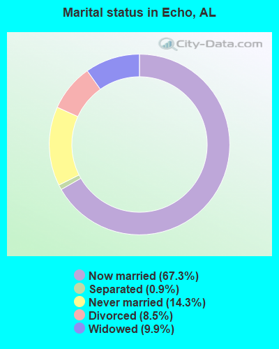
- Never married: 14.3%
- Now married: 67.3%
- Separated: 0.9%
- Widowed: 9.9%
- Divorced: 8.5%
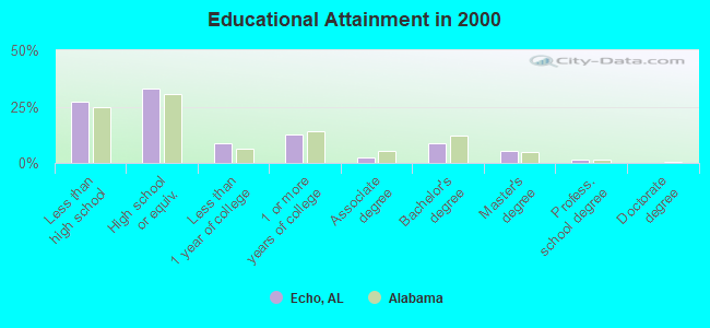
For population 25 years and over in Echo:
- High school or higher: 72.6%
- Bachelor's degree or higher: 15.6%
- Graduate or professional degree: 6.8%
- Unemployed: 4.0%
- Mean travel time to work (commute): 30.1 minutes
| Here: | 13.4 |
| Alabama average: | 13.2 |
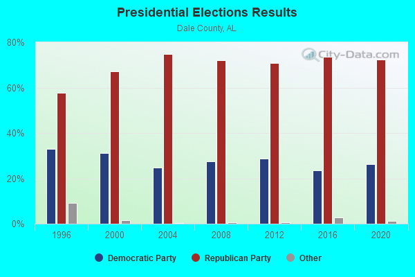
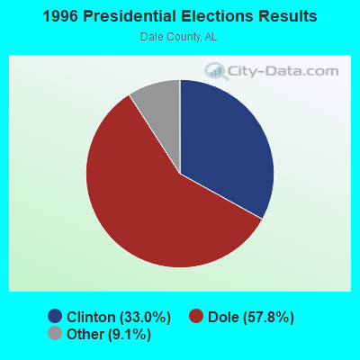
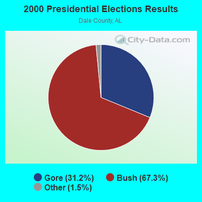


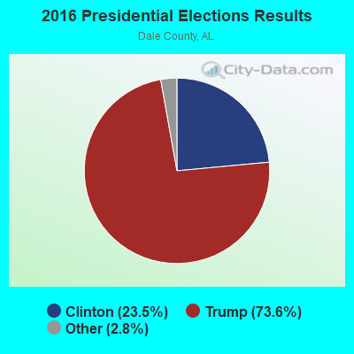

Graphs represent county-level data. Detailed 2008 Election Results
Religion statistics for Echo, AL (based on Dale County data)
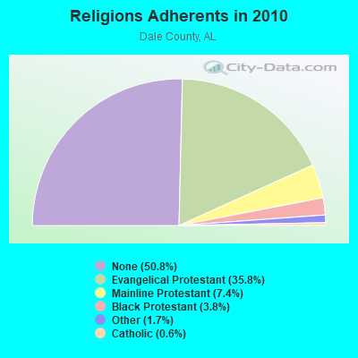
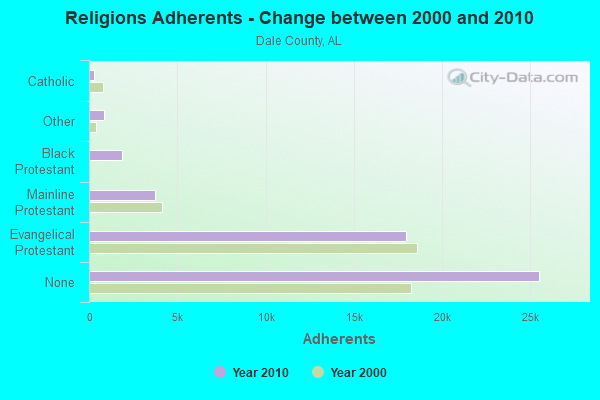
| Religion | Adherents | Congregations |
|---|---|---|
| Evangelical Protestant | 17,979 | 68 |
| Mainline Protestant | 3,712 | 27 |
| Black Protestant | 1,891 | 9 |
| Other | 872 | 4 |
| Catholic | 278 | 1 |
| None | 25,519 | - |
Food Environment Statistics:
| Dale County: | 1.66 / 10,000 pop. |
| State: | 1.89 / 10,000 pop. |
| Dale County: | 0.21 / 10,000 pop. |
| Alabama: | 0.20 / 10,000 pop. |
| This county: | 0.62 / 10,000 pop. |
| State: | 0.65 / 10,000 pop. |
| Dale County: | 6.65 / 10,000 pop. |
| Alabama: | 6.32 / 10,000 pop. |
| Dale County: | 4.98 / 10,000 pop. |
| Alabama: | 5.75 / 10,000 pop. |
| Here: | 12.5% |
| Alabama: | 11.8% |
| Here: | 33.1% |
| Alabama: | 31.7% |
| Dale County: | 11.1% |
| Alabama: | 13.5% |
13.66% of this county's 2021 resident taxpayers lived in other counties in 2020 ($45,663 average adjusted gross income)
| Here: | 13.66% |
| Alabama average: | 6.87% |
0.30% of residents moved from foreign countries ($1,125 average AGI)
Dale County: 0.30% Alabama average: 0.02%
Top counties from which taxpayers relocated into this county between 2020 and 2021:
| from Houston County, AL | |
| from Coffee County, AL | |
| from Henry County, AL |
12.52% of this county's 2020 resident taxpayers moved to other counties in 2021 ($49,280 average adjusted gross income)
| Here: | 12.52% |
| Alabama average: | 6.41% |
0.33% of residents moved to foreign countries ($1,788 average AGI)
Dale County: 0.33% Alabama average: 0.02%
Top counties to which taxpayers relocated from this county between 2020 and 2021:
| to Houston County, AL | |
| to Coffee County, AL | |
| to Henry County, AL |
Strongest AM radio stations in Echo:
- WQLS (1200 AM; 10 kW; OZARK, AL; Owner: STYLES BROADCASTING OF DOTHAN, INC.)
- WOOF (560 AM; 5 kW; DOTHAN, AL; Owner: WOOF, INC.)
- WAGF (1320 AM; 2 kW; DOTHAN, AL)
- WOZK (900 AM; 1 kW; OZARK, AL; Owner: OZARK B/CING. CORP.)
- WTKN (1560 AM; daytime; 5 kW; DALEVILLE, AL; Owner: JOSEPH A. ADAMS, SR.)
- WTBF (970 AM; 5 kW; TROY, AL; Owner: TROY BROADCASTING CORP.)
- WSTT (730 AM; 25 kW; THOMASVILLE, GA; Owner: MARION R. WILLIAMS)
- WJOX (690 AM; 50 kW; BIRMINGHAM, AL; Owner: CITADEL BROADCASTING COMPANY)
- WMAC (940 AM; 50 kW; MACON, GA; Owner: CUMULUS LICENSING CORP.)
- WASG (550 AM; 25 kW; ATMORE, AL; Owner: 550 AM, INC)
- WGST (640 AM; 50 kW; ATLANTA, GA; Owner: CITICASTERS LICENSES, L.P.)
- WNSI (810 AM; 50 kW; JACKSONVILLE, AL; Owner: UNITED BROADCASTING NETWORK, INC.)
- WMSP (740 AM; 10 kW; MONTGOMERY, AL; Owner: CUMULUS LICENSING CORP.)
Strongest FM radio stations in Echo:
- WAQG (91.7 FM; OZARK, AL; Owner: AMERICAN FAMILY ASSOCIATION)
- WJRL-FM (103.9 FM; OZARK, AL; Owner: STYLES BROADCASTING OF DOTHAN, INC.)
- WTVY-FM (95.5 FM; DOTHAN, AL; Owner: STYLES BROADCASTING OF DOTHAN, INC.)
- WOOF-FM (99.7 FM; DOTHAN, AL; Owner: WOOF, INC.)
- WIZB (94.3 FM; ABBEVILLE, AL; Owner: CELEBRATIONS COMMUNICATIONS COMPANY, INC.)
- WDYF (90.3 FM; DOTHAN, AL; Owner: FAITH BROADCASTING, INC.)
- WXUS (100.5 FM; FORT RUCKER, AL; Owner: SKYWAY BROADCASTING, LTD.)
- WKMX (106.7 FM; ENTERPRISE, AL; Owner: WKMX, INC.)
- WDJR (96.9 FM; ENTERPRISE, AL; Owner: GULF SOUTH COMMUNICATIONS, INC.)
- WESP (102.5 FM; DOTHAN, AL; Owner: GULF SOUTH COMMUNICATIONS, INC)
- WAGF-FM (101.3 FM; DOTHAN, AL; Owner: WILSON BROADCASTING CO., INC.)
- WQLD (104.3 FM; LUVERNE, AL; Owner: CAPSTAR TX LIMITED PARTNERSHIP)
- WZHT (105.7 FM; TROY, AL; Owner: CAPSTAR TX LIMITED PARTNERSHIP)
- WOAB (104.9 FM; OZARK, AL; Owner: OZARK BROADCASTING CORPORATION)
- WRWA (88.7 FM; DOTHAN, AL; Owner: TROY STATE UNIVERSITY)
- WZTZ (101.1 FM; ELBA, AL; Owner: ELBA RADIO COMPANY)
- WJJN (92.1 FM; COLUMBIA, AL; Owner: WILSON BROADCASTING CO., INC.)
- WVOB (91.3 FM; DOTHAN, AL; Owner: BETHANY BIBLE COLLEGE & B.T.S. INC.)
- WGTF (89.5 FM; DOTHAN, AL; Owner: DOTHAN COMMUNITY EDUCL. RADIO, INC.)
TV broadcast stations around Echo:
- WGIQ (Channel 43; LOUISVILLE, AL; Owner: ALABAMA EDUCATIONAL TELEVISION COMMISSION)
- WDFX-TV (Channel 34; OZARK, AL; Owner: WAITT LICENSE CO. OF ALABAMA, L.L.C.)
- WDHN (Channel 18; DOTHAN, AL; Owner: MORRIS NETWORK OF ALABAMA, INC.)
- WTVY (Channel 4; DOTHAN, AL; Owner: GRAY MIDAMERICA TV LICENSEE CORP.)
- WJJN-LP (Channel 5; DOTHAN, AL; Owner: JAMES WILSON, III)
- WRJM-TV (Channel 67; TROY, AL; Owner: JOSIE PARK BROADCASTING, INC.)
- WSFA (Channel 12; MONTGOMERY, AL; Owner: LIBCO, INC.)
- WCOV-TV (Channel 20; MONTGOMERY, AL; Owner: WOODS COMMUNICATIONS CORPORATION)
- W41BN (Channel 41; DOTHAN, AL; Owner: TRINITY BROADCASTING NETWORK)
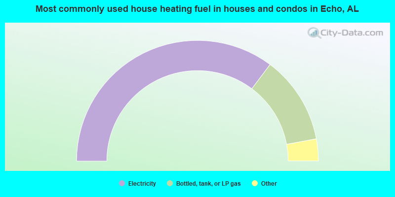
- 70.5%Electricity
- 23.6%Bottled, tank, or LP gas
- 3.3%Wood
- 1.7%Utility gas
- 0.9%No fuel used
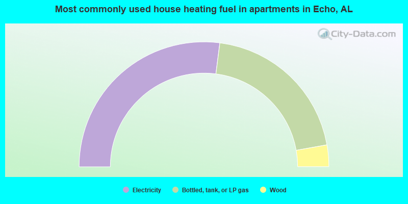
- 54.0%Electricity
- 40.3%Bottled, tank, or LP gas
- 5.6%Wood
Echo compared to Alabama state average:
- Median house value below state average.
- Unemployed percentage significantly below state average.
- Black race population percentage significantly below state average.
- Hispanic race population percentage significantly below state average.
- Foreign-born population percentage significantly below state average.
- Renting percentage below state average.
- Length of stay since moving in significantly above state average.
- Number of rooms per house significantly below state average.
- House age significantly below state average.