Flora, Oregon
Submit your own pictures of this place and show them to the world
- OSM Map
- General Map
- Google Map
- MSN Map

| Males: 68 | |
| Females: 82 |
| Median resident age: | 48.7 years |
| Oregon median age: | 36.3 years |
Zip code: 97828
| Flora: | $60,563 |
| OR: | $75,657 |
Estimated per capita income in 2022: $37,198 (it was $16,922 in 2000)
Estimated median house or condo value in 2022: $388,259 (it was $121,900 in 2000)
| Flora: | $388,259 |
| OR: | $475,600 |
Mean prices in 2022: all housing units: $473,224; detached houses: $509,938; mobile homes: $235,906
Detailed information about poverty and poor residents in Flora, OR
Compare current foreclosures near your location:
| Photo | Address | Area | Beds / Baths | Price | Details |
|---|---|---|---|---|---|

|
#1
S High St
Columbus, OH 43207
|
1,678 sq. feet
|
2 baths 4 beds |
$27,500
|
show details |

|
#2
Bayberry Cir
Columbus, OH 43207
|
1,564 sq. feet
|
1 baths 3 beds |
$127,500
|
show details |

|
#3
E 21st Ave
Columbus, OH 43211
|
1,061 sq. feet
|
1 baths 3 beds |
$179,900
|
show details |

|
#4
Rockwell Rd
Columbus, OH 43207
|
1,900 sq. feet
|
2 baths 4 beds |
show details | |

|
#5
Grove Cir
Columbus, OH 43230
|
1,236 sq. feet
|
2 baths 2 beds |
show details | |

|
#6
Rohr Rd
Groveport, OH 43125
|
1,212 sq. feet
|
1 baths 3 beds |
show details | |

|
#7
Oak Rd
Columbus, OH 43217
|
1,243 sq. feet
|
2 baths 3 beds |
show details | |

|
#8
Legend
Columbus, OH 43230
|
2,100 sq. feet
|
3 baths 3 beds |
show details | |

|
#9
Thrailkill Rd
Grove City, OH 43123
|
1,670 sq. feet
|
1 baths 4 beds |
show details | |

|
#10
Basswood Rd
Columbus, OH 43207
|
910 sq. feet
|
1 baths 2 beds |
show details |
| Photo | Address | Area | Beds / Baths | Price | Details |
|---|---|---|---|---|---|

|
#11
S 8th St
Columbus, OH 43207
|
1,053 sq. feet
|
1 baths 3 beds |
show details | |

|
#12
Troutbrook Dr
Dublin, OH 43017
|
2,628 sq. feet
|
3 baths 3 beds |
show details | |

|
#13
Corbins Mill Dr
Dublin, OH 43017
|
1,330 sq. feet
|
2 baths 2 beds |
show details | |

|
#14
Linview Ave
Columbus, OH 43211
|
1,085 sq. feet
|
1 baths 2 beds |
show details | |

|
#15
Scott St
Columbus, OH 43222
|
1,920 sq. feet
|
2 baths 5 beds |
show details | |

|
#16
Slaton Ct
Columbus, OH 43235
|
1,024 sq. feet
|
2 baths 2 beds |
show details | |

|
#17
Village Park Dr
Columbus, OH 43228
|
1,345 sq. feet
|
2 baths 3 beds |
show details | |

|
#18
Bluebird Ct
Westerville, OH 43081
|
976 sq. feet
|
2 baths 3 beds |
show details | |

|
#19
E Mound St
Columbus, OH 43209
|
1,665 sq. feet
|
2 baths 4 beds |
show details | |

|
#20
Eminence Ln
Grove City, OH 43123
|
1,704 sq. feet
|
3 baths 4 beds |
show details |
| Photo | Address | Area | Beds / Baths | Price | Details |
|---|---|---|---|---|---|

|
#21
Arklow Way
Canal Winchester, OH 43110
|
980 sq. feet
|
2 baths 2 beds |
show details | |

|
#22
Gilman Rd
Columbus, OH 43228
|
1,142 sq. feet
|
3 baths 3 beds |
show details | |

|
#23
Ashby Rd
Columbus, OH 43209
|
1,129 sq. feet
|
2 baths 3 beds |
show details | |

|
#24
Passage Creek Dr
Dublin, OH 43016
|
1,504 sq. feet
|
3 baths 2 beds |
show details | |

|
#25
Boston Harbor Way
Orient, OH 43146
|
1,300 sq. feet
|
3 baths 2 beds |
show details | |

|
#26
Floribunda Dr
Columbus, OH 43209
|
1,604 sq. feet
|
2 baths 3 beds |
show details | |

|
#27
Cleggan St
Canal Winchester, OH 43110
|
1,356 sq. feet
|
3 baths 3 beds |
show details | |

|
#28
Melrose Ave
Columbus, OH 43211
|
1,488 sq. feet
|
1 baths 4 beds |
show details | |

|
#29
Karikal Dr
Westerville, OH 43081
|
1,260 sq. feet
|
2 baths 3 beds |
show details | |

|
#30
Rohr Rd
Groveport, OH 43125
|
1,926 sq. feet
|
3 baths 3 beds |
show details |
| Photo | Address | Area | Beds / Baths | Price | Details |
|---|---|---|---|---|---|

|
#31
Rhoads Ave
Columbus, OH 43207
|
1,030 sq. feet
|
1 baths 3 beds |
show details | |

|
#32
Lewis Rd
Columbus, OH 43207
|
1,976 sq. feet
|
2 baths 4 beds |
show details | |

|
#33
Battalion Pl
Galloway, OH 43119
|
1,552 sq. feet
|
2 baths 3 beds |
show details | |

|
#34
Maize Rd
Columbus, OH 43224
|
1,678 sq. feet
|
2 baths 3 beds |
show details | |

|
#35
Oakland Park Ave
Columbus, OH 43224
|
1,127 sq. feet
|
1 baths 3 beds |
show details | |

|
#36
E Livingston Ave
Reynoldsburg, OH 43068
|
1,404 sq. feet
|
2 baths 4 beds |
show details | |

|
#37
Golden Cloud Ln
Columbus, OH 43228
|
1,576 sq. feet
|
3 baths 3 beds |
show details | |

|
#38
Blendon Grove Way
Columbus, OH 43230
|
976 sq. feet
|
3 baths 2 beds |
show details | |

|
#39
San Miguel Pl
Reynoldsburg, OH 43068
|
1,024 sq. feet
|
2 baths 2 beds |
show details | |

|
#40
Meadowleigh Way
Columbus, OH 43230
|
976 sq. feet
|
3 baths 2 beds |
show details |
| Photo | Address | Area | Beds / Baths | Price | Details |
|---|---|---|---|---|---|

|
#41
Blendon Point Dr
Columbus, OH 43230
|
896 sq. feet
|
2 baths 2 beds |
show details | |

|
#42
Clement Dr
Columbus, OH 43085
|
1,078 sq. feet
|
2 baths 3 beds |
show details | |

|
#43
Oldenburgh Way
Dublin, OH 43016
|
1,566 sq. feet
|
3 baths 3 beds |
show details | |

|
#44
Lieutenant Dr
Galloway, OH 43119
|
1,848 sq. feet
|
3 baths 3 beds |
show details | |

|
#45
Sandrell Dr
Columbus, OH 43228
|
1,132 sq. feet
|
2 baths 3 beds |
show details | |

|
#46
Alderson Ct
Columbus, OH 43228
|
1,224 sq. feet
|
3 baths 3 beds |
show details | |

|
#47
Brentwood Rd
Columbus, OH 43209
|
3,716 sq. feet
|
4 baths 4 beds |
show details | |

|
#48
Meadowsview Ln
Hilliard, OH 43026
|
2,972 sq. feet
|
4 baths 4 beds |
show details | |

|
#49
Holly River Ave
Dublin, OH 43016
|
1,335 sq. feet
|
3 baths 2 beds |
show details | |

|
Check over 1 million property listings on Foreclosure.com!
|
browse all offers | |||

- 15396.2%White alone
- 31.9%Two or more races
- 31.9%Hispanic

 Recent articles from our blog. Our writers, many of them Ph.D. graduates or candidates, create easy-to-read articles on a wide variety of topics.
Current Local Time: PST time zone
Elevation: 4360 feet
Land area: 475.6 square miles.
Population density: 0.3 people per square mile (very low).

| Flora CCD: | 0.5% ($567) |
| Oregon: | 1.2% ($1,687) |
Nearest city with pop. 50,000+: Kennewick, WA  (80.3 miles , pop. 54,693).
Nearest city with pop. 200,000+: Portland, OR (247.4 miles , pop. 529,121).
Nearest city with pop. 1,000,000+: Los Angeles, CA (818.2 miles , pop. 3,694,820).
Nearest cities:
), Latitude: 45.90 N, Longitude: 117.55 W
Area code commonly used in this area: 541


| Here: | 4.6% |
| Oregon: | 3.9% |
Average climate in Flora, Oregon
Based on data reported by over 4,000 weather stations


Earthquake activity:
Flora-area historical earthquake activity is significantly above Oregon state average. It is 1185% greater than the overall U.S. average.On 10/28/1983 at 14:06:06, a magnitude 7.3 (6.2 MB, 7.3 MS, 7.0 MW, Class: Major, Intensity: VIII - XII) earthquake occurred 222.2 miles away from the city center, causing 2 deaths (2 shaking deaths) and 3 injuries, causing $15,000,000 total damage
On 8/18/1959 at 06:37:13, a magnitude 7.7 (7.7 UK) earthquake occurred 347.9 miles away from the city center, causing $26,000,000 total damage
On 10/3/1915 at 06:52:48, a magnitude 7.6 (7.6 UK) earthquake occurred 373.4 miles away from the city center
On 4/13/1949 at 19:55:42, a magnitude 7.0 (7.0 UK) earthquake occurred 253.4 miles away from Flora center, causing $80,000,000 total damage
On 3/31/2020 at 23:52:30, a magnitude 6.5 (6.5 MW, Depth: 7.5 mi, Class: Strong, Intensity: VII - IX) earthquake occurred 154.4 miles away from the city center
On 2/28/2001 at 18:54:32, a magnitude 6.8 (6.5 MB, 6.6 MS, 6.8 MW) earthquake occurred 253.5 miles away from the city center, causing $2,000,000,000 total damage and $305,000,000 insured losses
Magnitude types: body-wave magnitude (MB), surface-wave magnitude (MS), moment magnitude (MW)
Natural disasters:
The number of natural disasters in Wallowa County (9) is smaller than the US average (15).Major Disasters (Presidential) Declared: 6
Emergencies Declared: 2
Causes of natural disasters: Floods: 5, Storms: 3, Winter Storms: 2, Drought: 1, Heavy Rain: 1, Hurricane: 1, Landslide: 1, Mudslide: 1, Snow: 1, Other: 1 (Note: some incidents may be assigned to more than one category).
Colleges/universities with over 2000 students nearest to Flora:
- Walla Walla Community College (about 38 miles; Walla Walla, WA; Full-time enrollment: 4,263)
- Lewis-Clark State College (about 44 miles; Lewiston, ID; FT enrollment: 3,199)
- Eastern Oregon University (about 48 miles; La Grande, OR; FT enrollment: 3,127)
- Washington State University (about 61 miles; Pullman, WA; FT enrollment: 25,055)
- University of Idaho (about 63 miles; Moscow, ID; FT enrollment: 10,416)
- Columbia Basin College (about 80 miles; Pasco, WA; FT enrollment: 5,111)
- Eastern Washington University (about 111 miles; Cheney, WA; FT enrollment: 11,643)
Points of interest:
Notable locations in Flora: Bone Spring Campground (A), Joseph Canyon Viewpoint (B), Jaussaud Corral (C), Feagin Ranch (D), Eden Community Hall (E), United State Fish and Wildlife River Testing Site (F), Skyline Recreation Site (G), Timothy Spring Campground (H), Mottet Recreation Site (I), Mud Creek Boat Launch (J), Troy Boat Access 1 (K), Troy Boat Access 2 (L), Sled Springs Work Center (M), Bear Canyon Campground (N), Deduck Forest Camp (O), Timothy Guard Station (P), Wallowa County Branch Library Troy Elementary School (Q). Display/hide their locations on the map
Cemeteries: Lost Prairie Cemetery (1), Nicoson Cemetery (2), Bartlett Cemetery (3), Eden Cemetery (4), Paradise Cemetery (5). Display/hide their locations on the map
Lakes and reservoirs: Wade Pond (A), Reed Reservoir (B). Display/hide their locations on the map
Streams, rivers, and creeks: Hidden Branch (A), Jaussaud Creek (B), Evans Creek (C), Elk Creek (D), Ditch Creek (E), Courtney Creek (F), Burnt Creek (G), Buck Creek (H), Bobcat Creek (I). Display/hide their locations on the map
Park in Flora: Grande Ronde Scenic Area (1). Display/hide its location on the map
| This place: | 2.1 people |
| Oregon: | 2.5 people |
| This place: | 65.5% |
| Whole state: | 63.4% |
| This place: | 7.3% |
| Whole state: | 8.0% |
Likely homosexual households (counted as self-reported same-sex unmarried-partner households)
- Lesbian couples: 0.0% of all households
- Gay men: 1.8% of all households
| This place: | 14.4% |
| Whole state: | 11.6% |
For population 15 years and over in Flora:

- Never married: 2.7%
- Now married: 85.7%
- Separated: 0.0%
- Widowed: 5.4%
- Divorced: 6.2%
For population 25 years and over in Flora:
- High school or higher: 84.8%
- Bachelor's degree or higher: 25.0%
- Graduate or professional degree: 10.7%
- Mean travel time to work (commute): 18.5 minutes


| Here: | 10.3 |
| Oregon average: | 11.5 |

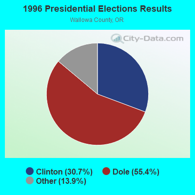
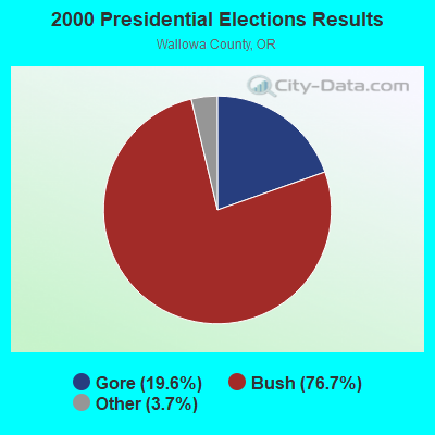


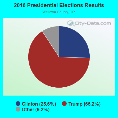

Graphs represent county-level data. Detailed 2008 Election Results
Religion statistics for Flora, OR (based on Wallowa County data)
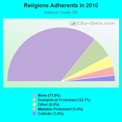
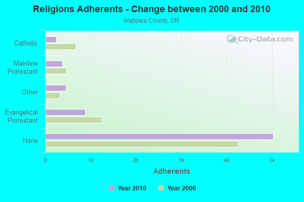
| Religion | Adherents | Congregations |
|---|---|---|
| Evangelical Protestant | 887 | 13 |
| Other | 462 | 4 |
| Mainline Protestant | 377 | 6 |
| Catholic | 250 | 2 |
| None | 5,032 | - |
Food Environment Statistics:
| Here: | 10.38 / 10,000 pop. |
| Oregon: | 2.03 / 10,000 pop. |
| Wallowa County: | 2.96 / 10,000 pop. |
| State: | 2.01 / 10,000 pop. |
| Here: | 1.48 / 10,000 pop. |
| Oregon: | 1.69 / 10,000 pop. |
| Wallowa County: | 29.65 / 10,000 pop. |
| State: | 9.93 / 10,000 pop. |
| Wallowa County: | 8.8% |
| Oregon: | 7.4% |
| Wallowa County: | 25.9% |
| Oregon: | 25.6% |
| Wallowa County: | 10.0% |
| Oregon: | 14.2% |
Strongest AM radio stations in Flora:
- KQQQ (1150 AM; 25 kW; PULLMAN, WA; Owner: RADIO PALOUSE, INC.)
- KTBI (810 AM; daytime; 50 kW; EPHRATA, WA; Owner: TACOMA BROADCASTERS, INCORPORATED)
- KOZE (950 AM; 5 kW; LEWISTON, ID; Owner: 4-K RADIO, INC.)
- KWEI (1260 AM; 50 kW; WEISER, ID; Owner: TREASURE VALLEY BROADCASTING CO.)
- KGA (1510 AM; 50 kW; SPOKANE, WA; Owner: CITADEL BROADCASTING COMPANY)
- KCLK (1430 AM; 5 kW; ASOTIN, WA; Owner: CLARKSTON BROADCASTERS, INC.)
- KMAX (840 AM; 10 kW; COLFAX, WA; Owner: PALOUSE COUNTRY, INC.)
- KBOI (670 AM; 50 kW; BOISE, ID; Owner: CITADEL BROADCASTING COMPANY)
- KRLC (1350 AM; 5 kW; CLARKSTON LEWISTON,, WA; Owner: IDA-VEND COMPANY, INC.)
- KUJ (1420 AM; 5 kW; WALLA WALLA, WA; Owner: ALEXANDRA COMMUNICATIONS)
- KFLD (870 AM; 10 kW; PASCO, WA; Owner: CAPSTAR TX LIMITED PARTNERSHIP)
- KERR (750 AM; 50 kW; POLSON, MT; Owner: ANDERSON RADIO BROADCASTING, INC.)
- KXLY (920 AM; 20 kW; SPOKANE, WA; Owner: SPOKANE RADIO, INC.)
Strongest FM radio stations in Flora:
- KUBQ (98.7 FM; LA GRANDE, OR; Owner: GRANDE RADIO, INC.)
- K208DB (89.5 FM; ENTERPRISE, ETC., OR; Owner: WALLOWA VALLEY TV ASSOCIATION, INC.)
- KNLT (95.7 FM; WALLA WALLA, WA; Owner: NEW NORTHWEST BROADCASTERS, LLC)
- KWWS (89.7 FM; WALLA WALLA, WA; Owner: WASHINGTON STATE UNIVERSITY)
- K234AD (94.7 FM; ENTERPRISE, OR; Owner: WALLOWA VALLEY TV ASSOCIATION, INC.)
- KGTS (91.3 FM; COLLEGE PLACE, WA; Owner: WALLA WALLA COLLEGE)
- KZZM (101.9 FM; WESTON, OR; Owner: BUTTERFIELD BROADCASTING CORPORATION)
- KZHR (92.5 FM; DAYTON, WA; Owner: COMMONWEALTH LICENSE SUBSIDIARY, LLC)
- KHSS (100.7 FM; WALLA WALLA, WA; Owner: TWO HEARTS COMMUNICATIONS, LLC)
- KNWO (90.1 FM; COTTONWOOD, ID; Owner: WASHINGTON STATE UNIVERSITY)
- KRKL (93.3 FM; WALLA WALLA, WA; Owner: EDUCATIONAL MEDIA FOUNDATION)
- KCMB (104.7 FM; BAKER, OR; Owner: OREGON TRAIL RADIO, INC.)
- KORT-FM (92.7 FM; GRANGEVILLE, ID; Owner: 4-K RADIO, INC.)
- KCLK-FM (94.1 FM; CLARKSTON, WA; Owner: CLARKSTON BROADCASTERS, INC.)
- KMOK (106.9 FM; LEWISTON, ID; Owner: IDA-VEND COMPANY, INC.)
- KVAB (102.9 FM; CLARKSTON, WA; Owner: CLARKSTON BROADCASTERS, INC.)
- KLRF (88.5 FM; MILTON-FREEWATER, OR; Owner: LIFETALK RADIO, INC.)
- KNWV (90.5 FM; CLARKSTON, WA; Owner: WASHINGTON STATE UNIVERSITY)
- KVTY (105.1 FM; LEWISTON, ID; Owner: IDAVEND CO. INC.)
FCC Registered Broadcast Land Mobile Towers:
1- Day Ridge Approx 7 1/2 Mi Sw (Lat: 45.828194 Lon: -117.398222), Structure height: 12 m, Call Sign: WNNE302, Licensee ID: L00099881,
Assigned Frequencies: 469.675 MHz, Grant Date: 03/18/1999, Expiration Date: 04/26/2004, Cancellation Date: 06/27/2004, Registrant: Kenneth F Coreson, 81060 Day Ridge Rd, Enterprise, OR 97828, Phone: (503) 828-7726

- 43.8%Wood
- 22.9%Fuel oil, kerosene, etc.
- 18.8%Electricity
- 14.6%Bottled, tank, or LP gas

- 40.0%Bottled, tank, or LP gas
- 40.0%Wood
- 20.0%Fuel oil, kerosene, etc.
Flora compared to Oregon state average:
- Unemployed percentage significantly below state average.
- Black race population percentage significantly below state average.
- Hispanic race population percentage significantly below state average.
- Median age significantly above state average.
- Foreign-born population percentage significantly below state average.
- Length of stay since moving in significantly above state average.
- Number of rooms per house significantly below state average.
- House age significantly below state average.
- Number of college students significantly below state average.