Percentage of residents living in poverty in 2022: 7.7%
(6.9% for White Non-Hispanic residents, 8.3% for Black residents, 4.2% for Hispanic or Latino residents, 0.9% for other race residents, 15.4% for two or more races residents)
According to our research of Georgia and other state lists, there were 21 registered sex offenders living in Georgetown, Georgia as of May 06, 2024. The ratio of all residents to sex offenders in Georgetown is 615 to 1. The ratio of registered sex offenders to all residents in this city is lower than the state average.
Recent articles from our blog. Our writers, many of them Ph.D. graduates or candidates, create easy-to-read articles on a wide variety of topics.
Latest news from Georgetown, GA collected exclusively by city-data.com from local newspapers, TV, and radio stations
Ancestries: English (8.5%), American (6.5%), Irish (4.5%), German (3.4%), Nigerian (3.3%), Scottish (2.5%).
Current Local Time: EST time zone
Land area: 11.5 square miles.
Population density: 1,030 people per square mile (low).
1,188 residents are foreign born (3.9% Latin America, 2.6% Asia, 1.6% Africa).
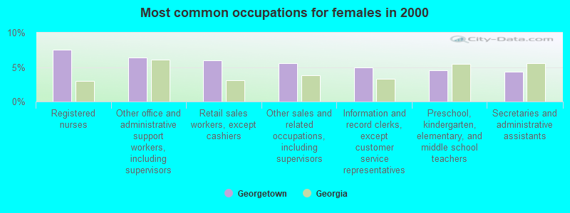
This place:
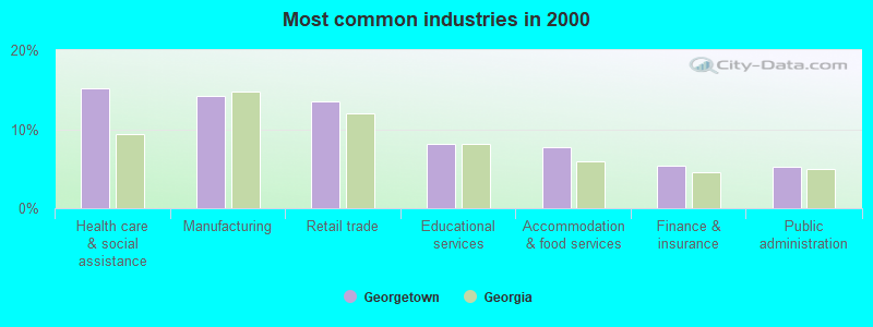
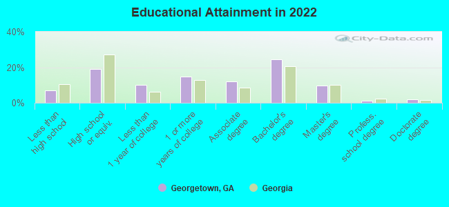
9.4%
Georgia:
10.4%
Median real estate property taxes paid for housing units with mortgages in 2022: $2,021 (0.8%) Median real estate property taxes paid for housing units with no mortgage in 2022: $1,610 (0.5%)
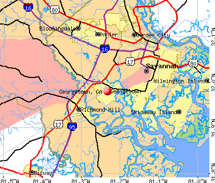
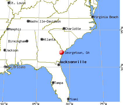
Nearest city with pop. 50,000+: Savannah, GA (9.0 miles , pop. 131,510).
Nearest city with pop. 200,000+: Jacksonville, FL (117.6 miles , pop. 735,617).
Nearest city with pop. 1,000,000+: Philadelphia, PA (650.5 miles , pop. 1,517,550).
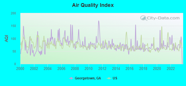
Air Quality Index (AQI) level in 2023 was 76.6. This is about average.
City:
76.6
U.S.:
72.6
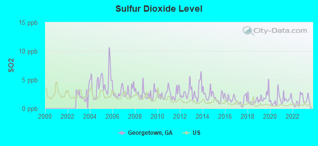
Sulfur Dioxide (SO2) [ppb] level in 2023 was 1.41. This is about average.Closest monitor was 8.2 miles away from the city center.
City:
1.41
U.S.:
1.51
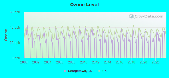
Ozone [ppb] level in 2022 was 28.0. This is about average.Closest monitor was 12.4 miles away from the city center.
City:
28.0
U.S.:
33.3
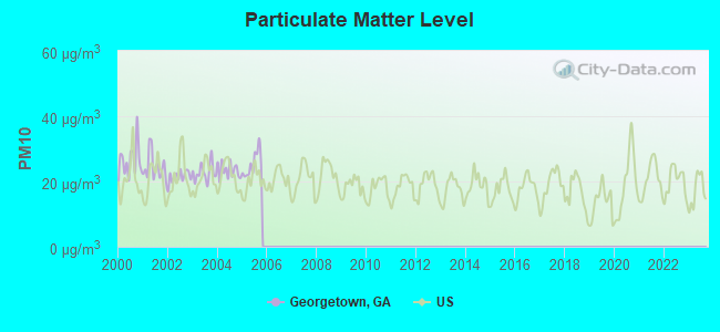
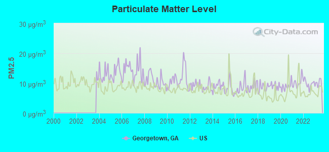
Particulate Matter (PM10) [µg/m3] level in 2005 was 25.2. This is worse than average.Closest monitor was 9.7 miles away from the city center.
City:
25.2
U.S.:
19.2
Particulate Matter (PM2.5) [µg/m3] level in 2023 was 9.90. This is worse than average.Closest monitor was 9.4 miles away from the city center.
City:
9.90
U.S.:
8.11
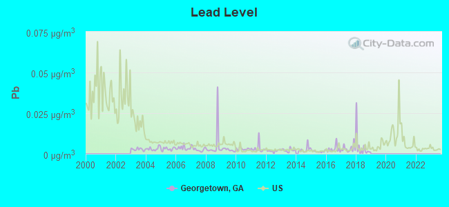
Lead (Pb) [µg/m3] level in 2018 was 0.00517. This is significantly better than average.Closest monitor was 10.7 miles away from the city center.
City:
0.00517
U.S.:
0.00931
Tornado activity:
Georgetown-area historical tornado activity is significantly below Georgia state average. It is 41% smaller than the overall U.S. average.
On 4/9/1998, a category F3 (max. wind speeds 158-206 mph) tornado 17.8 miles away from the Georgetown place center killed 2 peopleand injured 17 peopleand caused $3 million in damages.
On 5/11/2008, a category F4 (max. wind speeds 207-260 mph) tornado 41.6 miles away from the place center injured 9 peopleand caused $13 million in damages.
Earthquake activity:
Georgetown-area historical earthquake activity is significantly above Georgia state average. It is 48% smaller than the overall U.S. average.
On 11/22/1974 at 05:25:55, a magnitude 4.7 (4.7 MB, Class: Light, Intensity: IV - V) earthquake occurred 89.9 miles away from the city center On 8/2/1974 at 08:52:09, a magnitude 4.9 (4.3 MB, 4.9 LG) earthquake occurred 149.8 miles away from the city center On 8/21/1992 at 16:31:55, a magnitude 4.4 (4.1 MB, 4.1 LG, 4.4 LG, Depth: 6.2 mi) earthquake occurred 98.6 miles away from Georgetown center On 11/11/2002 at 23:39:29, a magnitude 4.0 (4.0 MB, Depth: 1.5 mi) earthquake occurred 81.3 miles away from the city center On 8/9/2020 at 12:07:37, a magnitude 5.1 (5.1 MW, Depth: 4.7 mi, Class: Moderate, Intensity: VI - VII) earthquake occurred 311.1 miles away from the city center On 4/17/1995 at 13:45:57, a magnitude 3.9 (3.9 LG, Depth: 6.2 mi, Class: Light, Intensity: II - III) earthquake occurred 95.4 miles away from Georgetown center Magnitude types: regional Lg-wave magnitude (LG), body-wave magnitude (MB), moment magnitude (MW)
Natural disasters:
The number of natural disasters in Chatham County (9) is smaller than the US average (15). Major Disasters (Presidential) Declared: 3 Emergencies Declared: 5
Causes of natural disasters: Hurricanes: 4, Floods: 2, Tornadoes: 2, Drought: 1, Heavy Rain: 1, Snowfall: 1, Storm: 1, Wind: 1, Winter Storm: 1, Other: 1 (Note: some incidents may be assigned to more than one category).
Hospitals and medical centers near Georgetown:
ABERCORN DIALYSIS (Dialysis Facility, about 5 miles away; SAVANNAH, GA)
ST JOSEPH'S HOSPITAL - SAVANNAH Acute Care Hospitals (about 5 miles away; SAVANNAH, GA)
ST JOSEPH'S HOSP TRANS CARE UN (Nursing Home, about 5 miles away; SAVANNAH, GA)
KINDRED TRANSITIONAL CARE AND REHAB - ABERCORN (Nursing Home, about 5 miles away; SAVANNAH, GA)
UNIHEALTH POST-ACUTE CARE - SAVANNAH (Nursing Home, about 6 miles away; SAVANNAH, GA)
BRYAN COUNTY HLTH AND REHAB CTR (Nursing Home, about 6 miles away; RICHMOND HILL, GA)
CHARLTON VISITING NURSES SERVICES- GREATER SAVAN (Home Health Center, about 7 miles away; POOLER, GA)
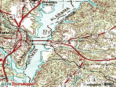
Notable locations in Georgetown: Camp O'Hara Boy Scout Camp (A), Vandiver Causeway (B), Georgetown Industrial Park (C), Georgetown Water Pollution Control Plant (D), Southside Fire Department Station 3 (E), Savannah Fire Department Station 12 (F), Quitman County Volunteer Fire Department Station 1 (G), Southside Fire Department Station 7 (H), Savannah Fire Department Station 15 (I). Display/hide their locations on the map
Churches in Georgetown include: Bethel Church (A), Georgetown Baptist Church (B), Coastal Christian Center (C), The Church of Jesus Christ of Latter Day Saints (D), Hawkins Chapel (E), Chevis Oaks Church (F), Ogeechee Church (G), New Mount Olive Church (H), Saint Bartholomews Church (I). Display/hide their locations on the map
Chatham County has a predicted average indoor radon screening level less than 2 pCi/L (pico curies per liter) - Low Potential
Drinking water stations with addresses in Georgetown and their reported violations in the past:
BONAPARTE`S RETREAT, INC. (Population served: 428, Groundwater):
Past monitoring violations:
Follow-up Or Routine LCR Tap M/R - In OCT-01-2012, Contaminant: Lead and Copper Rule. Follow-up actions: St Public Notif requested (MAR-18-2013), St Violation/Reminder Notice (MAR-18-2013), St Public Notif received (SEP-06-2013)
Likely homosexual households (counted as self-reported same-sex unmarried-partner households)
Lesbian couples: 0.7% of all households
Gay men: 0.3% of all households
3 people in group homes intended for adults in 2010
Banks with branches in Georgetown (2011 data):
Farmers State Bank: Georgetown Branch at 78 Main Street, branch established on 1998/11/23. Info updated 2006/11/03: Bank assets: $48.8 mil, Deposits: $45.3 mil, headquarters in Lumpkin, GA, negative income in the last year, 3 total offices
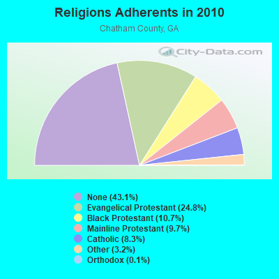
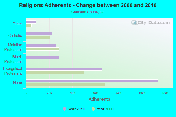
Religion statistics for Georgetown, GA (based on Chatham County data)
Religion
Adherents
Congregations
Evangelical Protestant
65,804
170
Black Protestant
28,308
57
Mainline Protestant
25,660
63
Catholic
22,109
10
Other
8,607
22
Orthodox
365
2
None
114,275
-
Source: Clifford Grammich, Kirk Hadaway, Richard Houseal, Dale E.Jones, Alexei Krindatch, Richie Stanley and Richard H.Taylor. 2012. 2010 U.S.Religion Census: Religious Congregations & Membership Study. Association of Statisticians of American Religious Bodies. Jones, Dale E., et al. 2002. Congregations and Membership in the United States 2000. Nashville, TN: Glenmary Research Center. Graphs represent county-level data
Aircraft: FREEMAN ARTHUR F CHALLENGER II (Category: Land, Seats: 2, Weight: Up to 12,499 Pounds), Engine: ROTAX SEE BOMBADIER (Reciprocating) N-Number: 101XX, N101XX, N-101XX, Serial Number: CH2-0604-2482, Year manufactured: 2004, Airworthiness Date: 11/24/2006, Certificate Issue Date: 09/04/2019 Registrant (Individual): Mark J Murray, 667 Hatcher Rd, Georgetown, GA 39854
Aircraft: QUAD CITY ULTRALIGHTS CHALLENGER 2 (Category: Land, Seats: 2, Weight: Up to 12,499 Pounds), Engine: ROTAX 503 SERIES (52 HP) (2 Cycle) N-Number: 155KL, N155KL, N-155KL, Serial Number: CH2-0500-1977, Year manufactured: 2000, Airworthiness Date: 07/19/2010, Certificate Issue Date: 12/09/2016 Registrant (Individual): Mark J Murray, 667 Hatcher Rd, Georgetown, GA 39854
Aircraft: EVERS JOHN H CHALLENGER 1 (Category: Land, Weight: Up to 12,499 Pounds), Engine: ROTAX 503 DCDI (52 HP) (Reciprocating) N-Number: 24JE, N24JE, N-24JE, Serial Number: 1298-0710, Year manufactured: 2008, Airworthiness Date: 12/03/2008, Certificate Issue Date: 06/16/2020 Registrant (Individual): Mark J Murray, 667 Hatcher Rd, Georgetown, GA 39854
Aircraft: STARLING DENNIS A RANS S-7 COURIER (Category: Land, Seats: 2, Weight: Up to 12,499 Pounds), Engine: BOMBARDIER ROTAX (ALL) (Reciprocating) N-Number: 41815, N41815, N-41815, Serial Number: 0491081, Year manufactured: 2004, Airworthiness Date: 02/04/2005, Certificate Issue Date: 05/08/2019 Registrant (Individual): Mark J Murray, 667 Hatcher Rd, Georgetown, GA 39854
Aircraft: MURRAY MARK J HURRICANE (Category: Land, Weight: Up to 12,499 Pounds), Engine: ROTAX 503 DCDI (52 HP) (2 Cycle) N-Number: 4407G, N4407G, N-4407G, Serial Number: 19692, Year manufactured: 2007, Airworthiness Date: 01/04/2008, Certificate Issue Date: 12/20/2007 Registrant (Individual): Mark J Murray, 667 Hatcher Rd, Georgetown, GA 39854
Home Mortgage Disclosure Act Aggregated Statistics For Year 2009 (Based on 2 partial tracts)
A) FHA, FSA/RHS & VA Home Purchase Loans
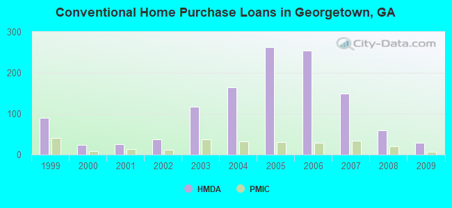
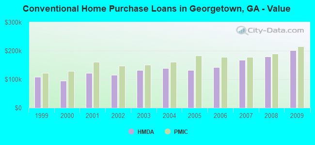
B) Conventional Home Purchase Loans
C) Refinancings
D) Home Improvement Loans
E) Loans on Dwellings For 5+ Families
F) Non-occupant Loans on < 5 Family Dwellings (A B C & D)
G) Loans On Manufactured Home Dwelling (A B C & D)
Number
Average Value
Number
Average Value
Number
Average Value
Number
Average Value
Number
Average Value
Number
Average Value
Number
Average Value
LOANS ORIGINATED
74
$173,313
29
$201,583
160
$189,045
3
$75,723
1
$5,851,910
21
$176,844
1
$63,100
APPLICATIONS APPROVED, NOT ACCEPTED
2
$192,590
2
$140,495
14
$161,873
0
$0
0
$0
1
$141,490
1
$48,850
APPLICATIONS DENIED
10
$164,236
2
$293,000
72
$189,179
4
$43,238
0
$0
7
$159,107
2
$41,035
APPLICATIONS WITHDRAWN
4
$190,365
3
$170,150
53
$184,320
1
$81,800
0
$0
4
$145,278
1
$30,800
FILES CLOSED FOR INCOMPLETENESS
2
$112,150
0
$0
7
$210,981
0
$0
0
$0
1
$135,450
0
$0
Aggregated Statistics For Year 2008 (Based on 2 partial tracts)
A) FHA, FSA/RHS & VA Home Purchase Loans
B) Conventional Home Purchase Loans
C) Refinancings
D) Home Improvement Loans
E) Loans on Dwellings For 5+ Families
F) Non-occupant Loans on < 5 Family Dwellings (A B C & D)
G) Loans On Manufactured Home Dwelling (A B C & D)
Number
Average Value
Number
Average Value
Number
Average Value
Number
Average Value
Number
Average Value
Number
Average Value
Number
Average Value
LOANS ORIGINATED
81
$173,049
60
$179,262
97
$175,120
6
$83,585
1
$5,246,050
28
$170,992
2
$54,120
APPLICATIONS APPROVED, NOT ACCEPTED
2
$168,945
2
$208,755
16
$171,720
2
$40,645
0
$0
1
$80,000
1
$30,260
APPLICATIONS DENIED
7
$171,166
5
$210,462
84
$175,741
14
$70,173
0
$0
4
$129,678
1
$57,220
APPLICATIONS WITHDRAWN
5
$170,192
10
$178,829
36
$203,851
3
$142,367
0
$0
3
$150,903
0
$0
FILES CLOSED FOR INCOMPLETENESS
2
$145,835
1
$195,910
9
$209,091
1
$100,410
0
$0
0
$0
0
$0
Aggregated Statistics For Year 2007 (Based on 2 partial tracts)
A) FHA, FSA/RHS & VA Home Purchase Loans
B) Conventional Home Purchase Loans
C) Refinancings
D) Home Improvement Loans
F) Non-occupant Loans on < 5 Family Dwellings (A B C & D)
G) Loans On Manufactured Home Dwelling (A B C & D)
Number
Average Value
Number
Average Value
Number
Average Value
Number
Average Value
Number
Average Value
Number
Average Value
LOANS ORIGINATED
49
$186,415
149
$168,112
116
$172,363
14
$83,544
31
$135,914
1
$39,440
APPLICATIONS APPROVED, NOT ACCEPTED
1
$250,440
16
$167,182
33
$149,690
7
$55,093
3
$141,543
1
$35,950
APPLICATIONS DENIED
5
$186,970
18
$165,514
108
$173,440
26
$74,245
8
$195,684
3
$63,810
APPLICATIONS WITHDRAWN
2
$194,150
22
$180,379
50
$175,753
6
$110,132
6
$159,833
0
$0
FILES CLOSED FOR INCOMPLETENESS
1
$127,570
3
$150,867
14
$213,007
2
$109,295
1
$75,500
0
$0
Aggregated Statistics For Year 2006 (Based on 2 partial tracts)
A) FHA, FSA/RHS & VA Home Purchase Loans
B) Conventional Home Purchase Loans
C) Refinancings
D) Home Improvement Loans
F) Non-occupant Loans on < 5 Family Dwellings (A B C & D)
G) Loans On Manufactured Home Dwelling (A B C & D)
Number
Average Value
Number
Average Value
Number
Average Value
Number
Average Value
Number
Average Value
Number
Average Value
LOANS ORIGINATED
89
$175,567
254
$141,982
124
$144,398
17
$55,345
53
$129,285
3
$59,500
APPLICATIONS APPROVED, NOT ACCEPTED
3
$153,767
28
$144,626
22
$126,046
4
$50,932
4
$128,562
2
$49,020
APPLICATIONS DENIED
5
$187,028
29
$156,579
105
$161,178
25
$65,369
7
$111,714
3
$47,500
APPLICATIONS WITHDRAWN
6
$181,850
24
$176,657
65
$160,716
4
$80,610
7
$149,723
0
$0
FILES CLOSED FOR INCOMPLETENESS
1
$225,640
8
$138,985
14
$195,471
1
$138,830
1
$107,110
0
$0
Aggregated Statistics For Year 2005 (Based on 2 partial tracts)
A) FHA, FSA/RHS & VA Home Purchase Loans
B) Conventional Home Purchase Loans
C) Refinancings
D) Home Improvement Loans
F) Non-occupant Loans on < 5 Family Dwellings (A B C & D)
G) Loans On Manufactured Home Dwelling (A B C & D)
Number
Average Value
Number
Average Value
Number
Average Value
Number
Average Value
Number
Average Value
Number
Average Value
LOANS ORIGINATED
57
$162,280
262
$131,527
116
$147,776
16
$66,145
46
$131,236
2
$43,055
APPLICATIONS APPROVED, NOT ACCEPTED
2
$198,185
31
$131,469
21
$124,799
3
$90,783
3
$102,280
2
$72,745
APPLICATIONS DENIED
3
$173,227
33
$109,721
92
$133,537
25
$40,401
6
$107,975
4
$54,175
APPLICATIONS WITHDRAWN
5
$161,506
28
$146,330
60
$128,976
8
$124,120
5
$156,340
1
$69,950
FILES CLOSED FOR INCOMPLETENESS
0
$0
9
$113,096
20
$173,504
1
$74,370
2
$94,295
0
$0
Aggregated Statistics For Year 2004 (Based on 2 partial tracts)
A) FHA, FSA/RHS & VA Home Purchase Loans
B) Conventional Home Purchase Loans
C) Refinancings
D) Home Improvement Loans
F) Non-occupant Loans on < 5 Family Dwellings (A B C & D)
G) Loans On Manufactured Home Dwelling (A B C & D)
Number
Average Value
Number
Average Value
Number
Average Value
Number
Average Value
Number
Average Value
Number
Average Value
LOANS ORIGINATED
57
$145,035
165
$138,191
121
$143,442
10
$61,155
36
$106,146
2
$37,045
APPLICATIONS APPROVED, NOT ACCEPTED
2
$140,380
16
$145,576
28
$149,109
4
$36,125
3
$92,243
2
$30,595
APPLICATIONS DENIED
4
$148,238
26
$107,993
85
$119,647
17
$35,101
7
$93,810
6
$47,965
APPLICATIONS WITHDRAWN
5
$126,526
18
$148,098
41
$125,330
3
$56,490
3
$105,100
0
$0
FILES CLOSED FOR INCOMPLETENESS
0
$0
3
$132,680
17
$136,745
2
$31,590
2
$98,040
0
$0
Aggregated Statistics For Year 2003 (Based on 2 partial tracts)
A) FHA, FSA/RHS & VA Home Purchase Loans
B) Conventional Home Purchase Loans
C) Refinancings
D) Home Improvement Loans
F) Non-occupant Loans on < 5 Family Dwellings (A B C & D)
Number
Average Value
Number
Average Value
Number
Average Value
Number
Average Value
Number
Average Value
LOANS ORIGINATED
53
$127,302
117
$132,394
266
$127,295
4
$17,035
34
$104,451
APPLICATIONS APPROVED, NOT ACCEPTED
1
$81,130
12
$108,124
25
$129,546
0
$0
3
$98,553
APPLICATIONS DENIED
2
$113,115
11
$111,537
72
$106,307
9
$21,122
6
$88,288
APPLICATIONS WITHDRAWN
3
$111,367
12
$161,903
44
$117,386
1
$64,420
2
$83,745
FILES CLOSED FOR INCOMPLETENESS
1
$85,730
3
$123,537
15
$127,589
1
$59,480
1
$127,180
Aggregated Statistics For Year 2002 (Based on 1 partial tract)
A) FHA, FSA/RHS & VA Home Purchase Loans
B) Conventional Home Purchase Loans
C) Refinancings
D) Home Improvement Loans
F) Non-occupant Loans on < 5 Family Dwellings (A B C & D)
Number
Average Value
Number
Average Value
Number
Average Value
Number
Average Value
Number
Average Value
LOANS ORIGINATED
13
$132,811
37
$115,944
33
$99,961
1
$30,640
12
$79,897
APPLICATIONS APPROVED, NOT ACCEPTED
0
$0
3
$72,840
5
$87,380
0
$0
0
$0
APPLICATIONS DENIED
3
$117,920
5
$78,278
18
$84,555
2
$11,765
1
$128,390
APPLICATIONS WITHDRAWN
1
$144,690
3
$150,073
6
$96,803
0
$0
0
$0
FILES CLOSED FOR INCOMPLETENESS
0
$0
1
$108,610
4
$115,432
0
$0
0
$0
Aggregated Statistics For Year 2001 (Based on 1 partial tract)
A) FHA, FSA/RHS & VA Home Purchase Loans
B) Conventional Home Purchase Loans
C) Refinancings
D) Home Improvement Loans
F) Non-occupant Loans on < 5 Family Dwellings (A B C & D)
Number
Average Value
Number
Average Value
Number
Average Value
Number
Average Value
Number
Average Value
LOANS ORIGINATED
11
$125,080
25
$121,800
26
$93,628
2
$22,950
5
$77,398
APPLICATIONS APPROVED, NOT ACCEPTED
0
$0
2
$106,865
3
$69,003
0
$0
0
$0
APPLICATIONS DENIED
2
$108,485
9
$78,701
13
$78,266
1
$16,030
1
$60,250
APPLICATIONS WITHDRAWN
1
$145,980
3
$108,053
8
$90,349
0
$0
0
$0
FILES CLOSED FOR INCOMPLETENESS
0
$0
1
$139,390
2
$80,750
0
$0
0
$0
Aggregated Statistics For Year 2000 (Based on 1 partial tract)
A) FHA, FSA/RHS & VA Home Purchase Loans
B) Conventional Home Purchase Loans
C) Refinancings
D) Home Improvement Loans
F) Non-occupant Loans on < 5 Family Dwellings (A B C & D)
Number
Average Value
Number
Average Value
Number
Average Value
Number
Average Value
Number
Average Value
LOANS ORIGINATED
10
$119,292
23
$95,614
9
$76,991
2
$11,315
4
$64,198
APPLICATIONS APPROVED, NOT ACCEPTED
0
$0
3
$83,743
1
$99,560
1
$17,070
0
$0
APPLICATIONS DENIED
1
$52,750
10
$56,181
9
$60,498
1
$10,210
0
$0
APPLICATIONS WITHDRAWN
1
$164,210
3
$112,277
5
$72,590
0
$0
0
$0
FILES CLOSED FOR INCOMPLETENESS
0
$0
1
$45,900
1
$100,470
0
$0
0
$0
Aggregated Statistics For Year 1999 (Based on 2 partial tracts)
A) FHA, FSA/RHS & VA Home Purchase Loans
B) Conventional Home Purchase Loans
C) Refinancings
D) Home Improvement Loans
F) Non-occupant Loans on < 5 Family Dwellings (A B C & D)
#3 on the list of "Top 101 cities with the lowest number of police officers per 1000 residents (population 5,000+)"
#23 on the list of "Top 101 cities that people commute from (largest negative percentage daily daytime population change due to commuting) (population 5,000+)"
#96 on the list of "Top 101 cities with the smallest racial income disparities between White and Black householders (with at least 200 householders)"
#87 (31419) on the list of "Top 101 zip codes with the most hotels or motels in 2005"
#8 on the list of "Top 101 counties with the lowest lead air pollution readings in 2012 (µg/m3)"
#20 on the list of "Top 101 counties with the highest lead air pollution readings in 2012 (µg/m3)"
#20 on the list of "Top 101 counties with the highest Sulfur Oxides Annual air pollution readings in 2012 (µg/m3)"
#32 on the list of "Top 101 counties with the largest decrease in the number of deaths per 1000 residents 2000-2006 to 2007-2013 (pop. 50,000+)"
#33 on the list of "Top 101 counties with the largest number of people moving in compared to moving out (pop. 50,000+)"


 Recent articles from our blog. Our writers, many of them Ph.D. graduates or candidates, create easy-to-read articles on a wide variety of topics.

 (9.0 miles