Gray-Griswold, Georgia
Submit your own pictures of this place and show them to the world
- OSM Map
- Google Map
- MSN Map
| Males: 11,442 | |
| Females: 12,184 |
| Median resident age: | 36.2 years |
| Georgia median age: | 33.4 years |
Zip code: 31032
| Gray-Griswold: | $70,545 |
| GA: | $72,837 |
Estimated per capita income in 2022: $32,566 (it was $19,229 in 2000)
Gray-Griswold CCD income, earnings, and wages data
Estimated median house or condo value in 2022: $199,498 (it was $81,700 in 2000)
| Gray-Griswold: | $199,498 |
| GA: | $297,400 |
Mean prices in 2022: all housing units: $188,273; detached houses: $221,346; townhouses or other attached units: $182,213; mobile homes: $68,656
Detailed information about poverty and poor residents in Gray-Griswold, GA
Compare current foreclosures near your location:
| Photo | Address | Area | Beds / Baths | Price | Details |
|---|---|---|---|---|---|

|
#1
Bayberry Cir
Columbus, OH 43207
|
1,564 sq. feet
|
1 baths 3 beds |
$127,500
|
show details |

|
#2
S High St
Columbus, OH 43207
|
1,678 sq. feet
|
2 baths 4 beds |
$31,900
|
show details |

|
#3
E 21st Ave
Columbus, OH 43211
|
1,061 sq. feet
|
1 baths 3 beds |
$187,900
|
show details |

|
#4
Wrexham Ave
Columbus, OH 43223
|
1,235 sq. feet
|
1 baths 3 beds |
show details | |

|
#5
Striebel Ct
Columbus, OH 43227
|
925 sq. feet
|
1 baths 3 beds |
show details | |

|
#6
Stoneybrook Blvd # 21a
Hilliard, OH 43026
|
1,231 sq. feet
|
2 baths 3 beds |
show details | |

|
#7
Derrer Rd -872
Columbus, OH 43204
|
1,667 sq. feet
|
2 baths 5 beds |
show details | |

|
#8
Midland Ave
Columbus, OH 43223
|
1,518 sq. feet
|
1 baths 2 beds |
show details | |

|
#9
Hiawatha Park Dr
Columbus, OH 43211
|
1,278 sq. feet
|
1 baths 4 beds |
show details | |

|
#10
Bretton Pl
Columbus, OH 43211
|
1,056 sq. feet
|
1 baths 3 beds |
show details |
| Photo | Address | Area | Beds / Baths | Price | Details |
|---|---|---|---|---|---|

|
#11
E Howard Rd
Columbus, OH 43207
|
1,056 sq. feet
|
1 baths 3 beds |
show details | |

|
#12
High Free Pike
West Jefferson, OH 43162
|
1,216 sq. feet
|
2 baths 4 beds |
show details | |

|
#13
Falls Peak Ln
Delaware, OH 43015
|
1,352 sq. feet
|
2 baths 2 beds |
show details | |

|
#14
S Richardson Ave
Columbus, OH 43204
|
1,520 sq. feet
|
2 baths 3 beds |
show details | |

|
#15
Mayflower Blvd
Columbus, OH 43213
|
1,591 sq. feet
|
2 baths 4 beds |
show details | |

|
#16
Marshrun Dr
Grove City, OH 43123
|
2,036 sq. feet
|
2 baths 4 beds |
show details | |

|
#17
Summertree Ln
Westerville, OH 43081
|
2,496 sq. feet
|
2 baths 3 beds |
show details | |

|
#18
Mink St SW
Pataskala, OH 43062
|
1,442 sq. feet
|
1 baths 3 beds |
show details | |

|
#19
Lehner Rd
Columbus, OH 43224
|
1,628 sq. feet
|
2 baths 4 beds |
show details | |

|
#20
N 18th St
Columbus, OH 43203
|
1,690 sq. feet
|
1 baths 4 beds |
show details |
| Photo | Address | Area | Beds / Baths | Price | Details |
|---|---|---|---|---|---|

|
#21
N Roys Ave
Columbus, OH 43204
|
1,248 sq. feet
|
2 baths 3 beds |
show details | |

|
#22
Armada Rd
Columbus, OH 43232
|
1,028 sq. feet
|
1 baths 4 beds |
show details | |

|
#23
Grasmere Ave
Columbus, OH 43211
|
720 sq. feet
|
1 baths 2 beds |
show details | |

|
#24
Brookstone Dr
Westerville, OH 43082
|
1,783 sq. feet
|
3 baths 3 beds |
show details | |

|
#25
Fergus Rd
Grove City, OH 43123
|
3,312 sq. feet
|
2 baths 4 beds |
show details | |

|
#26
E Welch Ave
Columbus, OH 43207
|
1,864 sq. feet
|
2 baths 4 beds |
show details | |

|
#27
N Wayne Ave
Columbus, OH 43204
|
947 sq. feet
|
1 baths 3 beds |
show details | |

|
#28
N Grener Ave
Columbus, OH 43228
|
1,120 sq. feet
|
1 baths 3 beds |
show details | |

|
#29
Glenmate Ct
Columbus, OH 43223
|
1,050 sq. feet
|
1 baths 3 beds |
show details | |

|
#30
Kingsglen Dr
Grove City, OH 43123
|
1,635 sq. feet
|
2 baths 4 beds |
show details |
| Photo | Address | Area | Beds / Baths | Price | Details |
|---|---|---|---|---|---|

|
#31
Elaine Rd
Columbus, OH 43213
|
764 sq. feet
|
1 baths 2 beds |
show details | |

|
#32
Trotter Dr
Columbus, OH 43207
|
1,478 sq. feet
|
1 baths 3 beds |
show details | |

|
#33
Bernadette Rd
Columbus, OH 43204
|
1,168 sq. feet
|
1 baths 3 beds |
show details | |

|
#34
Sleeping Meadow Dr
New Albany, OH 43054
|
3,211 sq. feet
|
2 baths 4 beds |
show details | |

|
#35
Scottwood Rd
Columbus, OH 43227
|
1,008 sq. feet
|
1 baths 3 beds |
show details | |

|
#36
Edgeview Rd
Columbus, OH 43207
|
1,700 sq. feet
|
1 baths 4 beds |
show details | |

|
#37
Hildreth Ave
Columbus, OH 43203
|
1,798 sq. feet
|
2 baths 4 beds |
show details | |

|
#38
Rosewood Ct
Powell, OH 43065
|
2,801 sq. feet
|
3 baths 4 beds |
show details | |

|
#39
S Hague Ave
Columbus, OH 43204
|
979 sq. feet
|
1 baths 2 beds |
show details | |

|
#40
Chester Rd
Columbus, OH 43221
|
3,300 sq. feet
|
4 baths 5 beds |
show details |
| Photo | Address | Area | Beds / Baths | Price | Details |
|---|---|---|---|---|---|

|
#41
London Groveport Rd
Grove City, OH 43123
|
816 sq. feet
|
1 baths 2 beds |
show details | |

|
#42
Fahlander Dr N
Columbus, OH 43229
|
1,338 sq. feet
|
2 baths 3 beds |
show details | |

|
#43
Fairfield Ave
Columbus, OH 43203
|
984 sq. feet
|
1 baths 2 beds |
show details | |

|
#44
Meadowbrook Dr
Columbus, OH 43207
|
1,752 sq. feet
|
2 baths 4 beds |
show details | |

|
#45
Oreily Dr
Galloway, OH 43119
|
1,533 sq. feet
|
2 baths 3 beds |
show details | |

|
#46
Bostwick Rd
Columbus, OH 43227
|
1,284 sq. feet
|
1 baths 4 beds |
show details | |

|
#47
Pendent Ln
Columbus, OH 43207
|
1,260 sq. feet
|
2 baths 3 beds |
show details | |

|
#48
Wesson Dr
Columbus, OH 43232
|
1,200 sq. feet
|
1 baths 3 beds |
show details | |

|
#49
Barthel Ave
Columbus, OH 43227
|
1,276 sq. feet
|
1 baths 3 beds |
show details | |

|
Check over 1 million property listings on Foreclosure.com!
|
browse all offers | |||

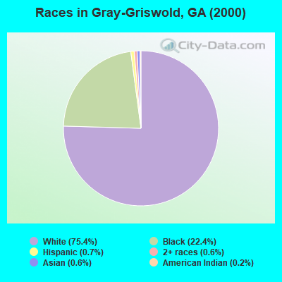
- 15,48275.4%White alone
- 4,60422.4%Black alone
- 1460.7%Hispanic
- 1210.6%Asian alone
- 1270.6%Two or more races
- 310.2%American Indian alone
- 130.06%Other race alone
- 20.01%Native Hawaiian and Other
Pacific Islander alone
Races in Gray-Griswold detailed stats: ancestries, foreign born residents, place of birth
 Recent articles from our blog. Our writers, many of them Ph.D. graduates or candidates, create easy-to-read articles on a wide variety of topics.
Current Local Time: EST time zone
Land area: 197.3 square miles.
Population density: 120 people per square mile (very low).
| Gray-Griswold CCD: | 0.7% ($597) |
| Georgia: | 0.9% ($919) |
Nearest city with pop. 50,000+: Macon, GA  (10.1 miles , pop. 97,255).
Nearest city with pop. 200,000+: Atlanta, GA (74.8 miles , pop. 416,474).
Nearest city with pop. 1,000,000+: Chicago, IL (654.9 miles , pop. 2,896,016).
Nearest cities:
), ), ), ), )Latitude: 32.96 N, Longitude: 83.53 W
Area code commonly used in this area: 478
| Here: | 2.6% |
| Georgia: | 2.9% |
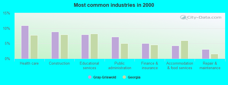
- Health care (10.9%)
- Construction (8.8%)
- Educational services (7.9%)
- Public administration (7.2%)
- Finance & insurance (5.0%)
- Accommodation & food services (4.3%)
- Repair & maintenance (3.1%)
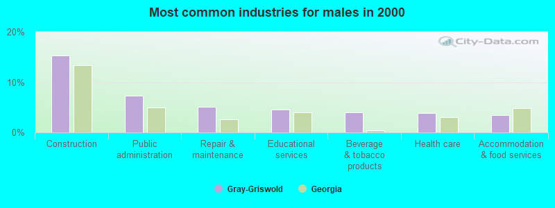
- Construction (15.3%)
- Public administration (7.3%)
- Repair & maintenance (5.1%)
- Educational services (4.6%)
- Beverage & tobacco products (4.0%)
- Health care (3.9%)
- Accommodation & food services (3.4%)
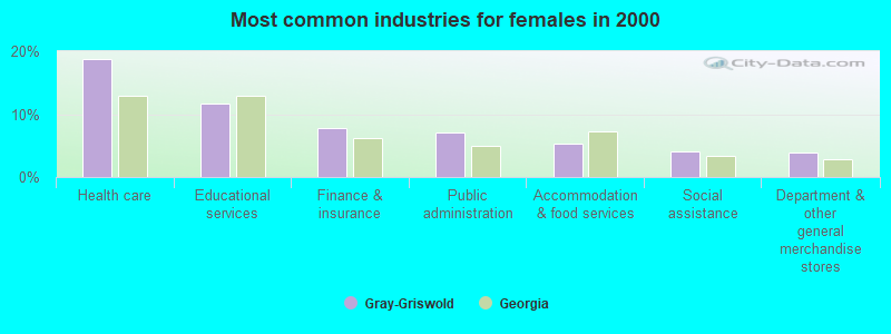
- Health care (18.8%)
- Educational services (11.7%)
- Finance & insurance (7.8%)
- Public administration (7.0%)
- Accommodation & food services (5.3%)
- Social assistance (4.1%)
- Department & other general merchandise stores (3.9%)
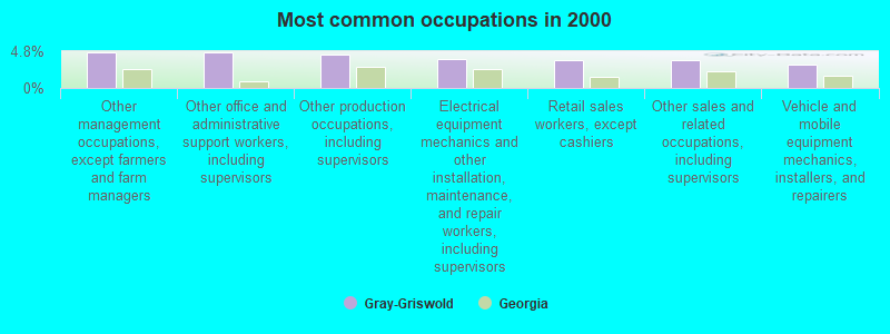
- Other management occupations, except farmers and farm managers (4.7%)
- Other office and administrative support workers, including supervisors (4.6%)
- Other production occupations, including supervisors (4.3%)
- Electrical equipment mechanics and other installation, maintenance, and repair workers, including supervisors (3.8%)
- Retail sales workers, except cashiers (3.7%)
- Other sales and related occupations, including supervisors (3.6%)
- Vehicle and mobile equipment mechanics, installers, and repairers (3.1%)
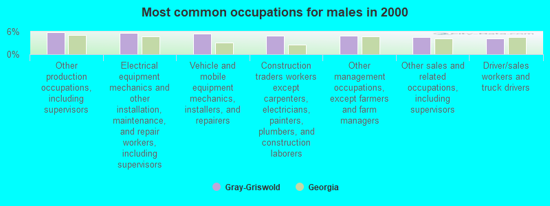
- Other production occupations, including supervisors (5.8%)
- Electrical equipment mechanics and other installation, maintenance, and repair workers, including supervisors (5.6%)
- Vehicle and mobile equipment mechanics, installers, and repairers (5.4%)
- Construction traders workers except carpenters, electricians, painters, plumbers, and construction laborers (5.0%)
- Other management occupations, except farmers and farm managers (4.9%)
- Other sales and related occupations, including supervisors (4.5%)
- Driver/sales workers and truck drivers (4.1%)

- Other office and administrative support workers, including supervisors (8.0%)
- Secretaries and administrative assistants (5.8%)
- Cashiers (5.4%)
- Registered nurses (4.9%)
- Retail sales workers, except cashiers (4.7%)
- Preschool, kindergarten, elementary, and middle school teachers (4.7%)
- Other management occupations, except farmers and farm managers (4.6%)
Average climate in Gray-Griswold, Georgia
Based on data reported by over 4,000 weather stations


(lower is better)
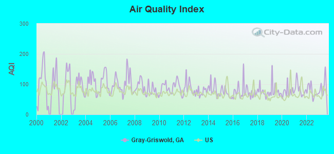
Air Quality Index (AQI) level in 2023 was 90.5. This is worse than average.
| City: | 90.5 |
| U.S.: | 72.6 |

Sulfur Dioxide (SO2) [ppb] level in 2023 was 1.31. This is about average. Closest monitor was 9.7 miles away from the city center.
| City: | 1.31 |
| U.S.: | 1.51 |
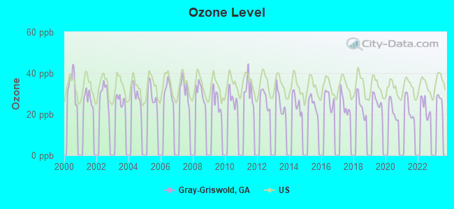
Ozone [ppb] level in 2022 was 23.4. This is significantly better than average. Closest monitor was 10.7 miles away from the city center.
| City: | 23.4 |
| U.S.: | 33.3 |
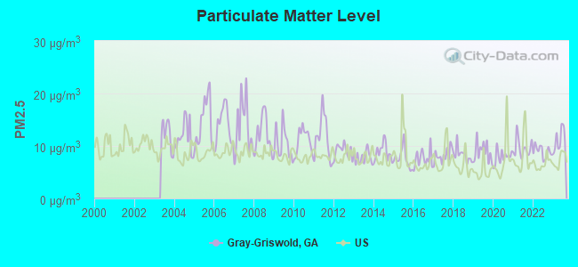
Particulate Matter (PM2.5) [µg/m3] level in 2023 was 11.1. This is worse than average. Closest monitor was 10.7 miles away from the city center.
| City: | 11.1 |
| U.S.: | 8.1 |
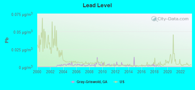
Lead (Pb) [µg/m3] level in 2018 was 0.00153. This is significantly better than average. Closest monitor was 9.8 miles away from the city center.
| City: | 0.00153 |
| U.S.: | 0.00931 |
Tornado activity:
Gray-Griswold-area historical tornado activity is near Georgia state average. It is 13% greater than the overall U.S. average.
On 11/22/1992, a category F4 (max. wind speeds 207-260 mph) tornado 16.0 miles away from the Gray-Griswold place center killed 5 people and injured 86 people and caused between $5,000,000 and $50,000,000 in damages.
On 4/30/1953, a category F4 tornado 25.2 miles away from the place center killed 18 people and injured 300 people and caused between $5,000,000 and $50,000,000 in damages.
Earthquake activity:
Gray-Griswold-area historical earthquake activity is significantly above Georgia state average. It is 10% greater than the overall U.S. average.On 8/2/1974 at 08:52:09, a magnitude 4.9 (4.3 MB, 4.9 LG, Class: Light, Intensity: IV - V) earthquake occurred 87.3 miles away from the city center
On 4/29/2003 at 08:59:39, a magnitude 4.9 (4.4 MB, 4.6 MW, 4.9 LG) earthquake occurred 160.6 miles away from the city center
On 4/29/2003 at 08:59:39, a magnitude 4.6 (4.6 MW, Depth: 12.3 mi) earthquake occurred 160.7 miles away from the city center
On 11/22/1974 at 05:25:55, a magnitude 4.7 (4.7 MB) earthquake occurred 196.7 miles away from Gray-Griswold center
On 11/30/1973 at 07:48:41, a magnitude 4.7 (4.7 MB, 4.6 ML) earthquake occurred 197.9 miles away from the city center
On 1/18/1999 at 07:00:53, a magnitude 4.8 (4.8 MB, 4.0 LG, Depth: 0.6 mi) earthquake occurred 217.7 miles away from the city center
Magnitude types: regional Lg-wave magnitude (LG), body-wave magnitude (MB), local magnitude (ML), moment magnitude (MW)
Natural disasters:
The number of natural disasters in Jones County (11) is smaller than the US average (15).Major Disasters (Presidential) Declared: 7
Emergencies Declared: 3
Causes of natural disasters: Tornadoes: 3, Winter Storms: 3, Floods: 2, Heavy Rains: 2, Hurricanes: 2, Tropical Storms: 2, Drought: 1, Storm: 1, Wind: 1, Other: 1 (Note: some incidents may be assigned to more than one category).
Hospitals and medical centers near Gray-Griswold:
- GRAY HEALTH AND REHABILITATION (Nursing Home, about 4 miles away; GRAY, GA)
- EAST MACON HEALTH CARE FACILITY (Nursing Home, about 6 miles away; MACON, GA)
- LYNN HAVEN HEALTH AND REHABILITATION (Nursing Home, about 7 miles away; GRAY, GA)
- ROSEWOOD NURSING CENTER, INC (Nursing Home, about 8 miles away; MACON, GA)
- EASTVIEW NH (Nursing Home, about 9 miles away; MACON, GA)
- EASTVIEW NURSING CENTER (Nursing Home, about 9 miles away; MACON, GA)
- HOSPITALITY CARE CTR OF MACON (Nursing Home, about 10 miles away; MACON, GA)
Colleges/universities with over 2000 students nearest to Gray-Griswold:
- Mercer University (about 12 miles; Macon, GA; Full-time enrollment: 6,297)
- Middle Georgia State College (about 16 miles; Macon, GA; FT enrollment: 7,091)
- Georgia College and State University (about 20 miles; Milledgeville, GA; FT enrollment: 6,271)
- Georgia Military College-Distance Learning Campuses (about 20 miles; Milledgeville, GA; FT enrollment: 6,438)
- Central Georgia Technical College (about 30 miles; Warner Robins, GA; FT enrollment: 6,829)
- Fort Valley State University (about 37 miles; Fort Valley, GA; FT enrollment: 3,200)
- Gordon State College (about 37 miles; Barnesville, GA; FT enrollment: 3,336)
Points of interest:
Notable locations in Gray-Griswold: River North Country Club (A), Camp Willis (B), Camp Joycliff (C), Gray Fire Department (D), Jones County Station 7B (E), Jones County Station 6 (F), Jones County Fire Department Station 7 (G), Jones County Fire Department Station 8 (H), Jones County Fire Department Station 6 (I), Jones County Fire Department Station 4 (J), Jones County Fire Department Station 2 (K), Jones County Fire Department Station 1 (L). Display/hide their locations on the map
Shopping Center: Jones County Shopping Center (1). Display/hide its location on the map
Churches in Gray-Griswold include: Calvery Church (A), Mount Zion Church (B), Frendship Church (C), Friendship Church (D), Saint Pauls Church (E), Kings Chapel (F), Mount Pleasant Church (G), Mountain Springs Church (H), New Hope Church (I). Display/hide their locations on the map
Cemeteries: Salem Cemetery (1), Edwards Cemetery (2), Ethridge - Minter Cemetery (3), Happoldt - Stevens Cemetery (4), James Cemetery (5), Mountain Springs Cemetery (6), New Salem Cemetery (7). Display/hide their locations on the map
Reservoirs: Baker Lake (A), Martin-Marietta Lake (B), Washburn Lake (C), Ray Lake (D), Jones Lake (E), Cherokee Products Lake (F), Briscoe Lake (G), Lake Tonawanda (H). Display/hide their locations on the map
Streams, rivers, and creeks: Pumphouse Branch (A), Mason Branch (B), Glawson Creek (C), Bray Branch (D), Bonner Creek (E), Town Creek (F), Buttlers Creek (G), Sand Creek (H), Rock Creek (I). Display/hide their locations on the map
Park in Gray-Griswold: Old Clinton Historic District (1). Display/hide its location on the map
| This place: | 2.7 people |
| Georgia: | 2.6 people |
| This place: | 68.0% |
| Whole state: | 70.7% |
| This place: | 3.8% |
| Whole state: | 4.8% |
Likely homosexual households (counted as self-reported same-sex unmarried-partner households)
- Lesbian couples: 0.2% of all households
- Gay men: 0.2% of all households
| This place: | 9.8% |
| Whole state: | 13.0% |
| This place: | 4.8% |
| Whole state: | 6.1% |
People in group quarters in Gray-Griswold in 2000:
- 262 people in nursing homes
- 74 people in local jails and other confinement facilities (including police lockups)
- 13 people in other noninstitutional group quarters
- 3 people in homes for the mentally retarded
For population 15 years and over in Gray-Griswold:
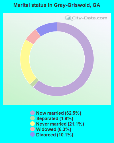
- Never married: 21.1%
- Now married: 62.5%
- Separated: 1.9%
- Widowed: 6.3%
- Divorced: 10.1%
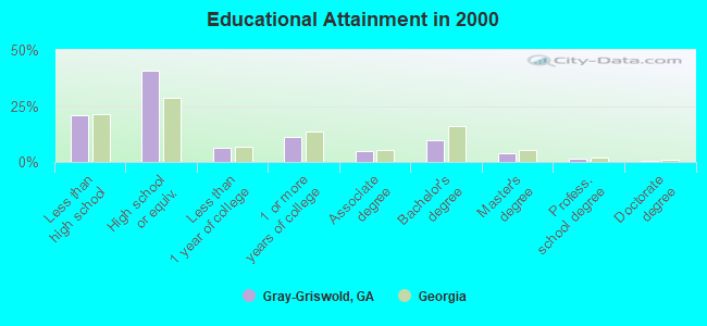
For population 25 years and over in Gray-Griswold:
- High school or higher: 78.9%
- Bachelor's degree or higher: 15.8%
- Graduate or professional degree: 5.9%
- Unemployed: 4.4%
- Mean travel time to work (commute): 26.6 minutes
| Here: | 11.6 |
| Georgia average: | 13.3 |
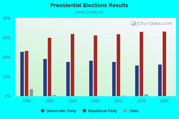
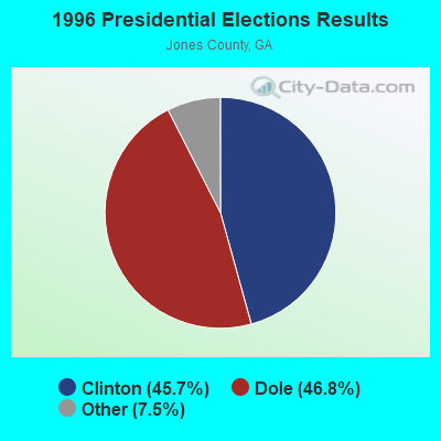
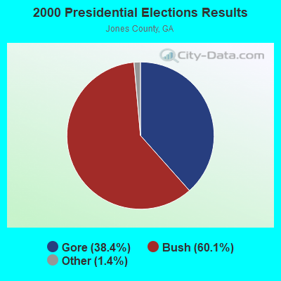


Graphs represent county-level data. Detailed 2008 Election Results
Religion statistics for Gray-Griswold, GA (based on Jones County data)
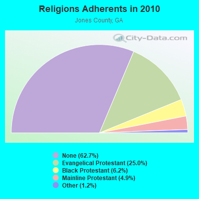
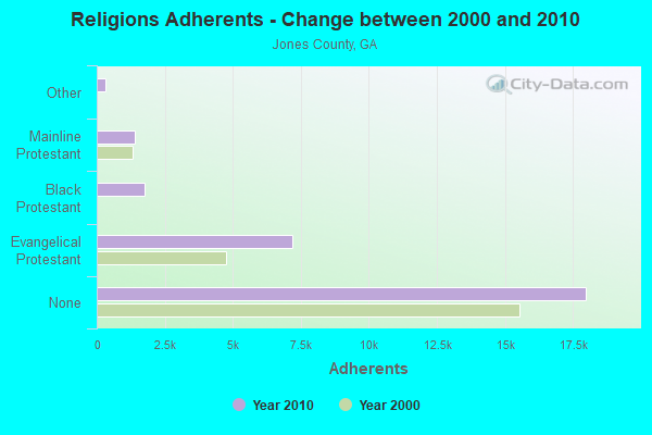
| Religion | Adherents | Congregations |
|---|---|---|
| Evangelical Protestant | 7,173 | 19 |
| Black Protestant | 1,764 | 11 |
| Mainline Protestant | 1,409 | 6 |
| Other | 334 | 2 |
| None | 17,989 | - |
Food Environment Statistics:
| Jones County: | 0.74 / 10,000 pop. |
| Georgia: | 1.91 / 10,000 pop. |
| Here: | 1.10 / 10,000 pop. |
| Georgia: | 0.86 / 10,000 pop. |
| Here: | 2.58 / 10,000 pop. |
| State: | 5.12 / 10,000 pop. |
| Here: | 2.95 / 10,000 pop. |
| Georgia: | 7.41 / 10,000 pop. |
| Jones County: | 11.5% |
| Georgia: | 10.4% |
| Jones County: | 29.6% |
| Georgia: | 27.8% |
| Jones County: | 12.6% |
| Georgia: | 14.6% |
Strongest AM radio stations in Gray-Griswold:
- WMAC (940 AM; 50 kW; MACON, GA; Owner: CUMULUS LICENSING CORP.)
- WXJO (1120 AM; daytime; 10 kW; GORDON, GA; Owner: ROBERTS COMMUNICATIONS, INC.)
- WLCG (1280 AM; 5 kW; MACON, GA)
- WBML (900 AM; 2 kW; MACON, GA; Owner: WBML, INC.)
- WNNG (1350 AM; 15 kW; WARNER ROBINS, GA; Owner: CHASE BROADCASTING, INC.)
- WGST (640 AM; 50 kW; ATLANTA, GA; Owner: CITICASTERS LICENSES, L.P.)
- WSB (750 AM; 50 kW; ATLANTA, GA; Owner: CXR HOLDINGS, INC.)
- WGUN (1010 AM; 50 kW; ATLANTA, GA; Owner: WGUN, INC.)
- WCNN (680 AM; 50 kW; NORTH ATLANTA, GA; Owner: DICKEY BROADCASTING COMPANY)
- WNEX (1400 AM; 1 kW; MACON, GA; Owner: RADIO PEACH, INC)
- WDDO (1240 AM; 1 kW; MACON, GA; Owner: CUMULUS LICENSING CORP.)
- WAOK (1380 AM; 50 kW; ATLANTA, GA; Owner: INFINITY BROADCASTING OPERATIONS, INC.)
- WQXI (790 AM; 28 kW; ATLANTA, GA; Owner: JEFFERSON-PILOT COMMUNICATIONS COMPANY OF GEORGIA)
Strongest FM radio stations in Gray-Griswold:
- WAYS (105.5 FM; MACON, GA; Owner: CUMULUS LICENSING CORP.)
- WFXM (107.1 FM; GORDON, GA; Owner: ROBERTS COMMUNICATIONS, INC.)
- WDEN-FM (99.1 FM; MACON, GA; Owner: CUMULUS LICENSING CORP.)
- WBKG (88.9 FM; MACON, GA; Owner: AMERICAN FAMILY ASSOCIATION)
- WYNF (96.5 FM; GRAY, GA; Owner: CLEVELAND RADIO LICENSES, LLC)
- WPEZ (93.7 FM; JEFFERSONVILLE, GA; Owner: CUMULUS LICENSING CORP.)
- WQMJ (100.1 FM; FORSYTH, GA; Owner: ROBERTS COMMUNICATIONS, INC.)
- WQBZ (106.3 FM; FORT VALLEY, GA; Owner: CLEVELAND RADIO LICENSES, LLC)
- WMKS (92.3 FM; MACON, GA; Owner: CUMULUS LICENSING CORP.)
- W282AE (104.3 FM; MACON, GA; Owner: BIBLE BROADCASTING NETWORK, INC.)
- WDCO-FM (89.7 FM; COCHRAN, GA; Owner: GEORGIA PUBLIC TELECOMMUNICATIONS COMMISSION)
- W203BH (88.5 FM; MACON, GA; Owner: CALVARY CHAPEL OF TWIN FALLS, INC.)
- WPWB (90.5 FM; BYRON, GA; Owner: AUGUSTA RADIO FELLOWSHIP INST., INC.)
- WKZR (102.3 FM; MILLEDGEVILLE, GA; Owner: WMVG, INC.)
- WLRR (100.7 FM; MILLEDGEVILLE, GA; Owner: PRESTON W. SMALL)
- WGUR (88.9 FM; MILLEDGEVILLE, GA; Owner: GEORGIA COLLEGE & STATE UNIVERSITY)
- WJTG (91.3 FM; FORT VALLEY, GA; Owner: JOY PUBLIC B/CNG CORP)
- WVKX (103.7 FM; IRWINTON, GA; Owner: WILKINSON BROADCASTING, INC.)
- WMGZ (97.7 FM; EATONTON, GA; Owner: MIDDLE GEORGIA COMMUNICATIONS, INC.)
- WRBV (101.7 FM; WARNER ROBINS, GA; Owner: CLEVELAND RADIO LICENSES, LLC)
TV broadcast stations around Gray-Griswold:
- WDMA-LP (Channel 32; MACON, GA; Owner: WORD OF GOD FELLOWSHIP, INC.)
- WPGA-TV (Channel 58; PERRY, GA; Owner: RADIO PERRY, INC.)
- WMGT-TV (Channel 41; MACON, GA; Owner: MORRIS NETWORK, INC.)
- WMAZ-TV (Channel 13; MACON, GA; Owner: GANNETT GEORGIA, L.P.)
- WGXA (Channel 24; MACON, GA; Owner: PIEDMONT TELEVISION OF MACON LICENSE LLC)
- WGNM (Channel 64; MACON, GA; Owner: GOOD NEWS TELEVISION)
- WDCO-TV (Channel 29; COCHRAN, GA; Owner: GEORGIA PUBLIC TELECOMMUNICATIONS COMMISSION)
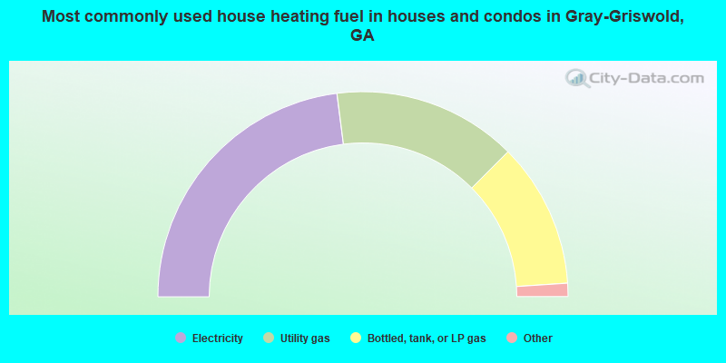
- 46.0%Electricity
- 29.1%Utility gas
- 22.9%Bottled, tank, or LP gas
- 1.3%Wood
- 0.4%Fuel oil, kerosene, etc.
- 0.2%No fuel used
- 0.1%Other fuel
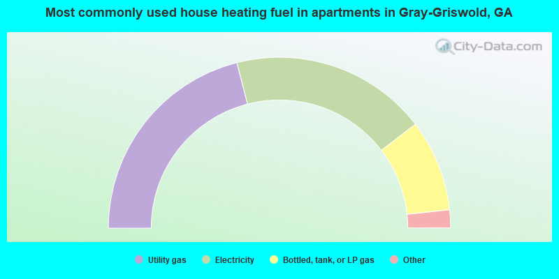
- 42.0%Utility gas
- 37.2%Electricity
- 17.4%Bottled, tank, or LP gas
- 2.9%Wood
- 0.6%Other fuel
Gray-Griswold compared to Georgia state average:
- Unemployed percentage significantly below state average.
- Hispanic race population percentage significantly below state average.
- Foreign-born population percentage significantly below state average.
- Renting percentage significantly below state average.
- Length of stay since moving in significantly above state average.
- Number of rooms per house significantly below state average.
- House age significantly below state average.
- Institutionalized population percentage significantly above state average.
Gray-Griswold on our top lists:
- #5 on the list of "Top 101 cities with largest percentage of males in industries: beverage and tobacco products (population 5,000+)"
- #13 on the list of "Top 101 cities with largest percentage of females in industries: beverage and tobacco products (population 5,000+)"
- #28 on the list of "Top 101 cities with largest percentage of females in occupations: electrical equipment mechanics and other installation, maintenance, and repair occupations including supervisors (population 5,000+)"
- #55 on the list of "Top 101 cities with largest percentage of males in occupations: electricians (population 5,000+)"
- #55 on the list of "Top 101 cities with largest percentage of females in occupations: vehicle and mobile equipment mechanics, installers, and repairers (population 5,000+)"
- #58 on the list of "Top 101 cities with largest percentage of females in industries: warehousing and storage (population 5,000+)"
- #59 on the list of "Top 101 cities with largest percentage of females in occupations: supervisors of transportation and material moving workers (population 5,000+)"
- #65 on the list of "Top 101 cities with largest percentage of males in occupations: supervisors of transportation and material moving workers (population 5,000+)"
- #68 on the list of "Top 101 cities with largest percentage of males in occupations: registered nurses (population 5,000+)"
- #72 on the list of "Top 101 cities with largest percentage of males in industries: rail transportation (population 5,000+)"
- #75 on the list of "Top 101 cities with largest percentage of males in industries: drugs, sundries, and chemical and allied products merchant wholesalers (population 5,000+)"
- #84 on the list of "Top 101 cities with largest percentage of males in industries: repair and maintenance (population 5,000+)"
- #85 on the list of "Top 101 cities with largest percentage of males in industries: farm product raw materials merchant wholesalers (population 5,000+)"
- #85 on the list of "Top 101 cities with largest percentage of females in industries: nonmetallic mineral products (population 5,000+)"
- #89 on the list of "Top 101 cities with largest percentage of males in industries: textile mills and textile products (population 5,000+)"
- #95 on the list of "Top 101 cities with largest percentage of males in industries: used merchandise, gift, novelty, and souvenir, and other miscellaneous stores (population 5,000+)"