Hampstead, Maryland
Submit your own pictures of this town and show them to the world
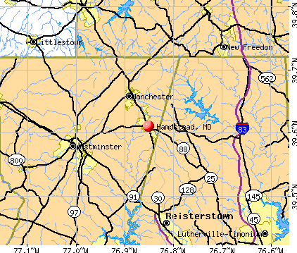
- OSM Map
- General Map
- Google Map
- MSN Map
Population change since 2000: +25.3%
| Males: 2,783 | |
| Females: 3,559 |
| Median resident age: | 41.2 years |
| Maryland median age: | 39.7 years |
Zip codes: 21074.
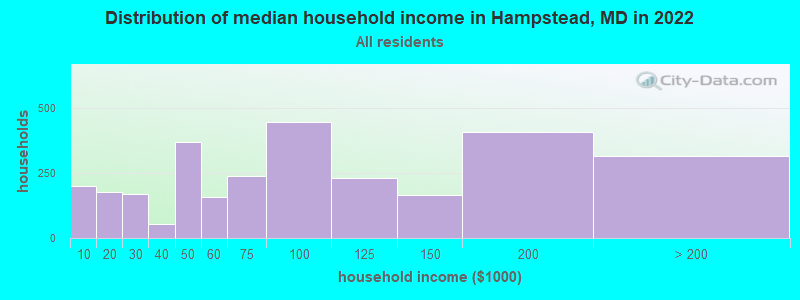
| Hampstead: | $82,184 |
| MD: | $94,991 |
Estimated per capita income in 2022: $46,134 (it was $22,730 in 2000)
Hampstead town income, earnings, and wages data
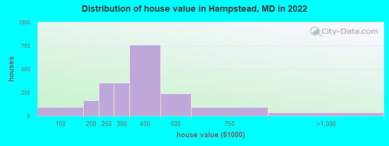
Estimated median house or condo value in 2022: $319,789 (it was $125,800 in 2000)
| Hampstead: | $319,789 |
| MD: | $398,100 |
Mean prices in 2022: all housing units: $320,373; detached houses: $352,014; townhouses or other attached units: $311,208; in 5-or-more-unit structures: $264,012
Median gross rent in 2022: $1,046.
(6.7% for White Non-Hispanic residents, 5.9% for Black residents, 32.4% for Hispanic or Latino residents)
Detailed information about poverty and poor residents in Hampstead, MD


Compare current foreclosures near Hampstead, MD:
| Photo | Address | Area | Beds / Baths | Price | Details |
|---|---|---|---|---|---|

|
#1
N Main Street
Hampstead, MD 21074
|
1,352 sq. feet
|
2 baths 3 beds |
$169,900
|
show details |

|
#2
Broadmoor Ct
Hampstead, MD 21074
|
2,184 sq. feet
|
3 baths - beds |
show details | |

|
#3
Harrowsmith Ct
Hampstead, MD 21074
|
1,926 sq. feet
|
3 baths - beds |
show details | |

|
#4
Glouster Cir
Hampstead, MD 21074
|
1,976 sq. feet
|
2 baths - beds |
show details | |

|
#5
Fairway Oaks Ct
Hampstead, MD 21074
|
2,262 sq. feet
|
2 baths - beds |
show details | |

|
#6
Century St
Hampstead, MD 21074
|
1,200 sq. feet
|
1 baths - beds |
show details | |

|
#7
Marshall Mill Rd
Hampstead, MD 21074
|
2,076 sq. feet
|
2 baths - beds |
show details | |

|
#8
Susanann Dr
Hampstead, MD 21074
|
1,200 sq. feet
|
1 baths - beds |
show details | |

|
#9
Maple Grove Rd
Hampstead, MD 21074
|
1,440 sq. feet
|
1 baths - beds |
show details | |

|
#10
Fairmount Rd
Hampstead, MD 21074
|
- sq. feet
|
- baths - beds |
show details |
| Photo | Address | Area | Beds / Baths | Price | Details |
|---|---|---|---|---|---|

|
#11
Greenmount Church Rd
Hampstead, MD 21074
|
- sq. feet
|
- baths - beds |
show details | |

|
#12
Singer St
Hampstead, MD 21074
|
- sq. feet
|
- baths - beds |
show details | |

|
#13
Falls Rd
Hampstead, MD 21074
|
- sq. feet
|
- baths - beds |
show details | |

|
#14
Hampstead Mexico Rd
Hampstead, MD 21074
|
- sq. feet
|
- baths - beds |
show details | |

|
#15
Willow Branch Way Unit 303
Owings Mills, MD 21117
|
1,200 sq. feet
|
2 baths 2 beds |
$259,000
|
show details |

|
#16
E George St
Westminster, MD 21157
|
924 sq. feet
|
1 baths 2 beds |
$329,900
|
show details |

|
#17
Ann Dr
Westminster, MD 21157
|
1,092 sq. feet
|
1 baths 3 beds |
$279,300
|
show details |

|
#18
Wembley Dr Unit 1b
Hampstead, MD 21074
|
- sq. feet
|
- baths - beds |
show details | |

|
#19
Cedarmere Rd
Owings Mills, MD 21117
|
1,162 sq. feet
|
1 baths 3 beds |
show details | |

|
#20
Sticks Rd
Glen Rock, PA 17327
|
- sq. feet
|
1 baths 2 beds |
show details |
| Photo | Address | Area | Beds / Baths | Price | Details |
|---|---|---|---|---|---|

|
#21
Rainflower Path
Sparks Glencoe, MD 21152
|
1,181 sq. feet
|
2 baths 3 beds |
show details | |

|
#22
Bollinger Rd
Littlestown, PA 17340
|
1,343 sq. feet
|
2 baths 3 beds |
show details | |

|
#23
Sara Ln
Hanover, PA 17331
|
1,632 sq. feet
|
2 baths 3 beds |
show details | |

|
#24
Hanover St
Spring Grove, PA 17362
|
1,256 sq. feet
|
2 baths 3 beds |
show details | |

|
#25
Rayville Rd
Parkton, MD 21120
|
1,864 sq. feet
|
3 baths 3 beds |
show details | |

|
#26
Sheraton Rd
Randallstown, MD 21133
|
1,413 sq. feet
|
1 baths 3 beds |
show details | |

|
#27
Filbert St
Hanover, PA 17331
|
1,128 sq. feet
|
2 baths 3 beds |
show details | |

|
#28
Cypress Grove Ct
Owings Mills, MD 21117
|
1,280 sq. feet
|
4 baths 3 beds |
show details | |

|
#29
Valley Manor Rd Apt 3b
Owings Mills, MD 21117
|
1,346 sq. feet
|
2 baths 2 beds |
show details | |

|
#30
Doe Meadow Dr
Owings Mills, MD 21117
|
2,155 sq. feet
|
2 baths 4 beds |
show details |
| Photo | Address | Area | Beds / Baths | Price | Details |
|---|---|---|---|---|---|

|
#31
Blue Moon Lane
Westminster, MD 21157
|
3,113 sq. feet
|
4 baths 6 beds |
show details | |

|
#32
Joshua Dr
Hanover, PA 17331
|
- sq. feet
|
2 baths 5 beds |
show details | |

|
#33
Homestead Dr
Hanover, PA 17331
|
- sq. feet
|
2 baths 3 beds |
show details | |

|
#34
Whispering Meadow Dr
Randallstown, MD 21133
|
2,338 sq. feet
|
2 baths 4 beds |
show details | |

|
#35
Tevis Cir
Randallstown, MD 21133
|
1,804 sq. feet
|
2 baths 4 beds |
show details | |

|
#36
North St
Mc Sherrystown, PA 17344
|
1,612 sq. feet
|
1 baths 3 beds |
show details | |

|
#37
Albright Dr
Hanover, PA 17331
|
1,906 sq. feet
|
1 baths 2 beds |
show details | |

|
#38
Bowman Rd # B
Hanover, PA 17331
|
1,280 sq. feet
|
1 baths 3 beds |
show details | |

|
#39
Whitcraft Rd
New Freedom, PA 17349
|
1,568 sq. feet
|
1 baths 2 beds |
show details | |

|
#40
Trout Ln
Stewartstown, PA 17363
|
1,594 sq. feet
|
1 baths 3 beds |
show details |
| Photo | Address | Area | Beds / Baths | Price | Details |
|---|---|---|---|---|---|

|
#41
Gardenia Dr
Hanover, PA 17331
|
1,648 sq. feet
|
2 baths 3 beds |
show details | |

|
#42
Conewago Dr
Hanover, PA 17331
|
708 sq. feet
|
1 baths 3 beds |
show details | |

|
#43
S Center St
Hanover, PA 17331
|
1,292 sq. feet
|
1 baths 3 beds |
show details | |

|
#44
S Center St
Hanover, PA 17331
|
1,292 sq. feet
|
1 baths 3 beds |
show details | |

|
#45
Rosepointe Way
Spring Grove, PA 17362
|
1,842 sq. feet
|
2 baths 2 beds |
show details | |

|
#46
Senft Rd
Spring Grove, PA 17362
|
2,374 sq. feet
|
2 baths 4 beds |
show details | |

|
#47
Lois Ln
Shrewsbury, PA 17361
|
1,511 sq. feet
|
2 baths 3 beds |
show details | |

|
#48
Little Knoll Dr
Hanover, PA 17331
|
1,692 sq. feet
|
2 baths 3 beds |
show details | |

|
#49
Covington Dr
Shrewsbury, PA 17361
|
1,360 sq. feet
|
2 baths 3 beds |
show details | |

|
Check over 1 million property listings on Foreclosure.com!
|
browse all offers | |||


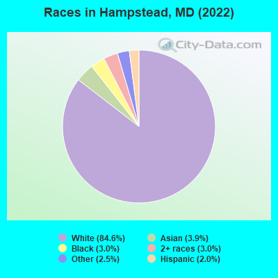
- 5,37784.6%White alone
- 2463.9%Asian alone
- 1923.0%Black alone
- 1893.0%Two or more races
- 1602.5%Other race alone
- 1252.0%Hispanic
Races in Hampstead detailed stats: ancestries, foreign born residents, place of birth
According to our research of Maryland and other state lists, there were 8 registered sex offenders living in Hampstead, Maryland as of May 02, 2024.
The ratio of all residents to sex offenders in Hampstead is 802 to 1.
The ratio of registered sex offenders to all residents in this city is near the state average.
Type |
2009 |
2010 |
2011 |
2012 |
2013 |
2014 |
2015 |
2016 |
2017 |
2018 |
2019 |
2020 |
2021 |
2022 |
|---|---|---|---|---|---|---|---|---|---|---|---|---|---|---|
| Murders (per 100,000) | 0 (0.0) | 1 (15.8) | 0 (0.0) | 0 (0.0) | 0 (0.0) | 0 (0.0) | 0 (0.0) | 0 (0.0) | 0 (0.0) | 0 (0.0) | 0 (0.0) | 0 (0.0) | 0 (0.0) | 0 (0.0) |
| Rapes (per 100,000) | 0 (0.0) | 1 (15.8) | 0 (0.0) | 1 (15.6) | 2 (31.6) | 1 (15.7) | 0 (0.0) | 0 (0.0) | 0 (0.0) | 0 (0.0) | 0 (0.0) | 1 (15.6) | 0 (0.0) | 0 (0.0) |
| Robberies (per 100,000) | 0 (0.0) | 1 (15.8) | 2 (31.3) | 1 (15.6) | 1 (15.8) | 0 (0.0) | 0 (0.0) | 0 (0.0) | 0 (0.0) | 1 (15.7) | 0 (0.0) | 0 (0.0) | 1 (15.5) | 1 (15.8) |
| Assaults (per 100,000) | 7 (127.2) | 4 (63.3) | 3 (47.0) | 2 (31.3) | 3 (47.3) | 4 (62.9) | 9 (141.3) | 2 (31.4) | 4 (62.9) | 3 (47.1) | 7 (109.4) | 2 (31.2) | 9 (139.8) | 9 (141.9) |
| Burglaries (per 100,000) | 10 (181.8) | 13 (205.6) | 13 (203.7) | 12 (187.7) | 14 (221.0) | 15 (235.8) | 8 (125.6) | 3 (47.1) | 8 (125.8) | 5 (78.6) | 12 (187.6) | 4 (62.4) | 4 (62.1) | 2 (31.5) |
| Thefts (per 100,000) | 85 (1,545) | 92 (1,455) | 66 (1,034) | 60 (938.5) | 60 (947.0) | 49 (770.4) | 61 (957.5) | 43 (675.6) | 44 (691.7) | 41 (644.2) | 19 (297.0) | 21 (327.6) | 20 (310.7) | 50 (788.4) |
| Auto thefts (per 100,000) | 2 (36.4) | 3 (47.4) | 2 (31.3) | 1 (15.6) | 1 (15.8) | 2 (31.4) | 2 (31.4) | 2 (31.4) | 6 (94.3) | 2 (31.4) | 0 (0.0) | 1 (15.6) | 0 (0.0) | 2 (31.5) |
| Arson (per 100,000) | 1 (18.2) | 2 (31.6) | 2 (31.3) | 2 (31.3) | 2 (31.6) | 2 (31.4) | 4 (62.8) | 1 (15.7) | 1 (15.7) | 2 (31.4) | 2 (31.3) | 1 (15.6) | 0 (0.0) | 2 (31.5) |
| City-Data.com crime index | 102.9 | 138.1 | 76.9 | 75.4 | 94.1 | 75.0 | 77.9 | 39.1 | 56.6 | 47.9 | 46.9 | 37.4 | 49.4 | 69.4 |
The City-Data.com crime index weighs serious crimes and violent crimes more heavily. Higher means more crime, U.S. average is 246.1. It adjusts for the number of visitors and daily workers commuting into cities.
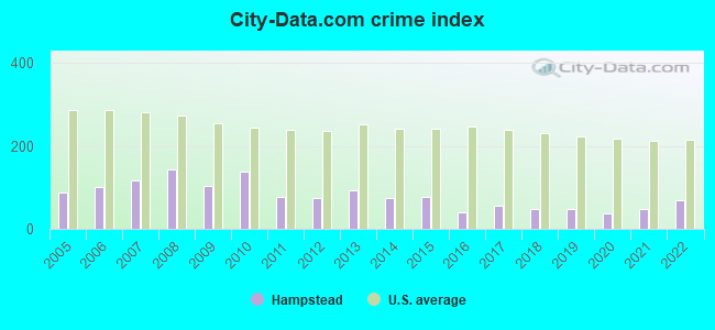
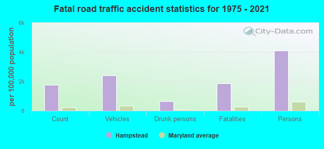
Crime rate in Hampstead detailed stats: murders, rapes, robberies, assaults, burglaries, thefts, arson
Full-time law enforcement employees in 2021, including police officers: 8 (7 officers - 6 male; 1 female).
| Officers per 1,000 residents here: | 1.09 |
| Maryland average: | 2.47 |
 Recent articles from our blog. Our writers, many of them Ph.D. graduates or candidates, create easy-to-read articles on a wide variety of topics.

 | Retirement move to Maryland, please help (116 replies) |
| I miss Maryland (106 replies) |
| Northern Maryland the hidden gem of Maryland (30 replies) |
| Carroll county maryland most diverse schools?? (6 replies) |
| Hampstead, maryland -2015 - diversity etc.?? (2 replies) |
| Moving to Maryland USA (10 replies) |
Latest news from Hampstead, MD collected exclusively by city-data.com from local newspapers, TV, and radio stations
Ancestries: American (32.1%), Irish (15.5%), English (10.4%), German (7.7%), Italian (3.5%), European (2.3%).
Current Local Time: EST time zone
Incorporated in 1888
Elevation: 914 feet
Land area: 2.68 square miles.
Population density: 2,365 people per square mile (low).
159 residents are foreign born (2.0% Asia, 0.3% Europe).
| This town: | 2.5% |
| Maryland: | 15.7% |
Median real estate property taxes paid for housing units with mortgages in 2022: $2,780 (0.9%)
Median real estate property taxes paid for housing units with no mortgage in 2022: $4,027 (1.3%)
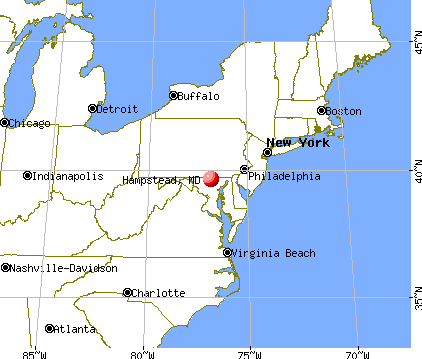
Nearest city with pop. 50,000+: Towson, MD  (19.8 miles , pop. 51,793).
Nearest city with pop. 200,000+: Baltimore, MD (24.4 miles , pop. 651,154).
Nearest city with pop. 1,000,000+: Philadelphia, PA (94.6 miles , pop. 1,517,550).
Nearest cities:
), ), Latitude: 39.61 N, Longitude: 76.85 W
Daytime population change due to commuting: -1,075 (-16.9%)
Workers who live and work in this town: 797 (21.7%)
Area codes: 443, 410
Property values in Hampstead, MD
Hampstead, Maryland accommodation & food services, waste management - Economy and Business Data
| Here: | 1.6% |
| Maryland: | 2.0% |
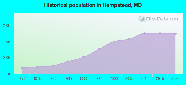
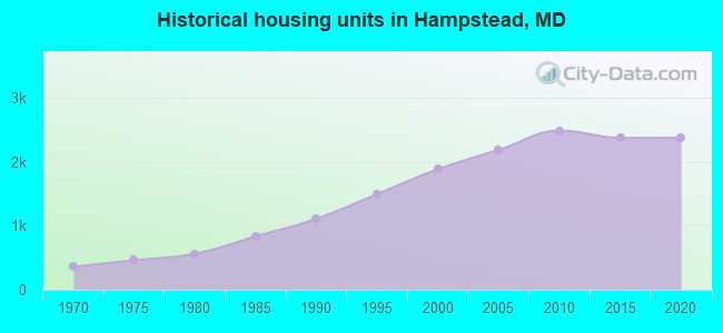
Population change in the 1990s: +2,385 (+89.2%).
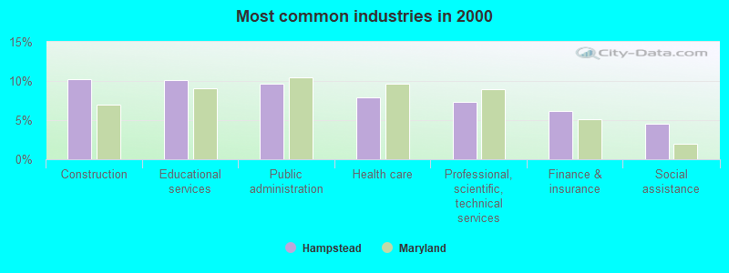
- Construction (10.3%)
- Educational services (10.1%)
- Public administration (9.7%)
- Health care (7.9%)
- Professional, scientific, technical services (7.3%)
- Finance & insurance (6.1%)
- Social assistance (4.6%)
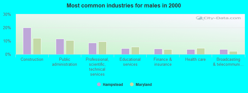
- Construction (20.1%)
- Public administration (11.5%)
- Professional, scientific, technical services (8.7%)
- Educational services (4.5%)
- Finance & insurance (4.3%)
- Health care (3.8%)
- Broadcasting & telecommunications (3.7%)
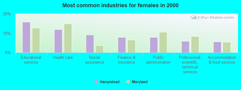
- Educational services (15.7%)
- Health care (12.0%)
- Social assistance (9.1%)
- Finance & insurance (7.9%)
- Public administration (7.9%)
- Professional, scientific, technical services (5.9%)
- Accommodation & food services (5.6%)

- Preschool, kindergarten, elementary, and middle school teachers (5.0%)
- Other sales and related occupations, including supervisors (4.5%)
- Other office and administrative support workers, including supervisors (4.5%)
- Secretaries and administrative assistants (4.2%)
- Computer specialists (3.7%)
- Other management occupations, except farmers and farm managers (3.6%)
- Driver/sales workers and truck drivers (3.4%)
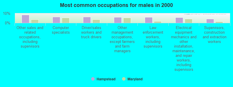
- Other sales and related occupations, including supervisors (8.6%)
- Computer specialists (6.4%)
- Driver/sales workers and truck drivers (6.3%)
- Other management occupations, except farmers and farm managers (6.1%)
- Law enforcement workers, including supervisors (6.1%)
- Electrical equipment mechanics and other installation, maintenance, and repair workers, including supervisors (5.6%)
- Supervisors, construction and extraction workers (4.3%)
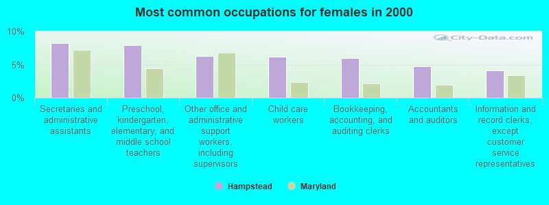
- Secretaries and administrative assistants (8.3%)
- Preschool, kindergarten, elementary, and middle school teachers (7.9%)
- Other office and administrative support workers, including supervisors (6.3%)
- Child care workers (6.2%)
- Bookkeeping, accounting, and auditing clerks (6.0%)
- Accountants and auditors (4.7%)
- Information and record clerks, except customer service representatives (4.1%)
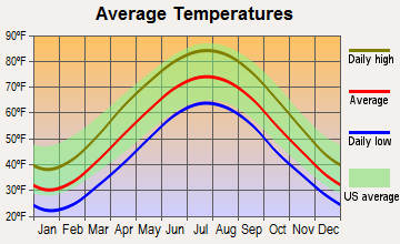
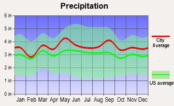
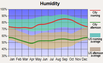
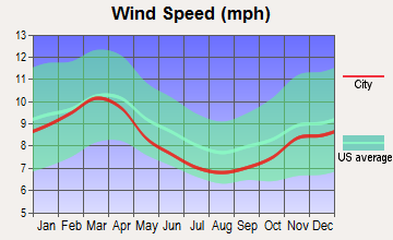
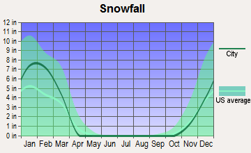
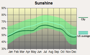
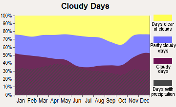
Average climate in Hampstead, Maryland
Based on data reported by over 4,000 weather stations
|
|

(lower is better)
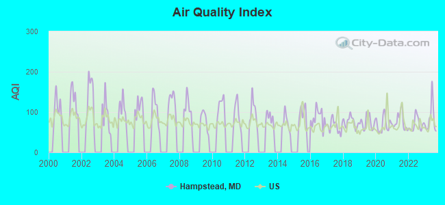
Air Quality Index (AQI) level in 2023 was 83.4. This is about average.
| City: | 83.4 |
| U.S.: | 72.6 |
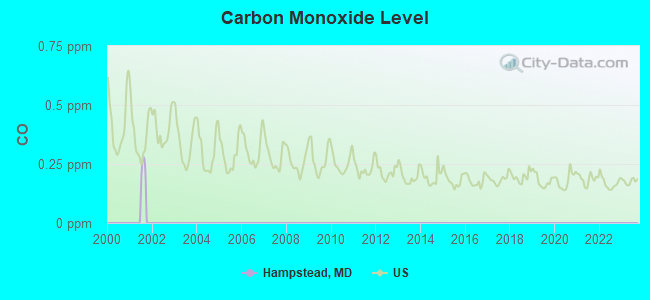
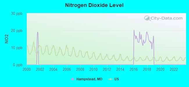
Nitrogen Dioxide (NO2) [ppb] level in 2018 was 14.1. This is significantly worse than average. Closest monitor was 8.2 miles away from the city center.
| City: | 14.1 |
| U.S.: | 5.1 |
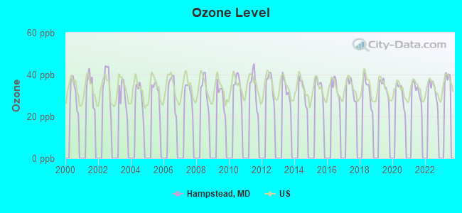
Ozone [ppb] level in 2022 was 32.5. This is about average. Closest monitor was 14.9 miles away from the city center.
| City: | 32.5 |
| U.S.: | 33.3 |
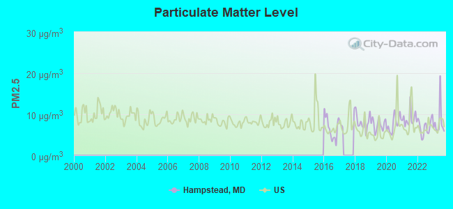
Particulate Matter (PM2.5) [µg/m3] level in 2023 was 8.11. This is about average. Closest monitor was 15.6 miles away from the city center.
| City: | 8.11 |
| U.S.: | 8.11 |
Tornado activity:
Hampstead-area historical tornado activity is slightly above Maryland state average. It is 19% greater than the overall U.S. average.
On 7/19/1996, a category F3 (max. wind speeds 158-206 mph) tornado 10.3 miles away from the Hampstead town center injured 3 people and caused $5 million in damages.
On 4/5/1952, a category F3 tornado 14.8 miles away from the town center injured 4 people and caused between $500,000 and $5,000,000 in damages.
Earthquake activity:
Hampstead-area historical earthquake activity is significantly above Maryland state average. It is 59% smaller than the overall U.S. average.On 8/23/2011 at 17:51:04, a magnitude 5.8 (5.8 MW, Depth: 3.7 mi, Class: Moderate, Intensity: VI - VII) earthquake occurred 131.4 miles away from the city center
On 1/16/1994 at 01:49:16, a magnitude 4.6 (4.6 MB, 4.6 LG, Depth: 3.1 mi, Class: Light, Intensity: IV - V) earthquake occurred 65.9 miles away from Hampstead center
On 9/25/1998 at 19:52:52, a magnitude 5.2 (4.8 MB, 4.3 MS, 5.2 LG, 4.5 MW, Depth: 3.1 mi) earthquake occurred 227.2 miles away from Hampstead center
On 1/16/1994 at 00:42:43, a magnitude 4.2 (4.2 MB, 4.0 LG, Depth: 3.1 mi) earthquake occurred 66.8 miles away from the city center
On 8/25/2011 at 05:07:52, a magnitude 4.5 (4.5 ML, Depth: 4.2 mi) earthquake occurred 129.8 miles away from Hampstead center
On 12/9/2003 at 20:59:18, a magnitude 4.5 (4.5 ML, Depth: 6.2 mi) earthquake occurred 143.8 miles away from Hampstead center
Magnitude types: regional Lg-wave magnitude (LG), body-wave magnitude (MB), local magnitude (ML), surface-wave magnitude (MS), moment magnitude (MW)
Natural disasters:
The number of natural disasters in Carroll County (17) is near the US average (15).Major Disasters (Presidential) Declared: 12
Emergencies Declared: 5
Causes of natural disasters: Hurricanes: 5, Floods: 4, Snowstorms: 3, Storms: 3, Winter Storms: 3, Blizzard: 1, Heavy Rain: 1, Snow: 1, Snowfall: 1, Tropical Storm: 1, Other: 1 (Note: some incidents may be assigned to more than one category).
Main business address for: BANK JOS A CLOTHIERS INC /DE/ (RETAIL-APPAREL & ACCESSORY STORES).
Hospitals and medical centers near Hampstead:
- LONGVIEW NSG. HOME (Nursing Home, about 8 miles away; MANCHESTER, MD)
- AMEDISYS HOME HEALTH OF WESTMINSTER (Home Health Center, about 8 miles away; WESTMINSTER, MD)
- LUTHERAN HOME CARE AND HOSPICE, INC (Home Health Center, about 8 miles away; WESTMINSTER, MD)
- AMBULATORY CARE CTR RICHARD N DIXON (Hospital, about 8 miles away; WESTMINSTER, MD)
- CARROLL HOME CARE (Home Health Center, about 9 miles away; WESTMINSTER, MD)
- THERAPY MANAGEMENT SVCS/DBA COMP REHAB (Hospital, about 9 miles away; WESTMINSTER, MD)
- CARROLL HOSPITAL CENTER Acute Care Hospitals (about 9 miles away; WESTMINSTER, MD)
Colleges/universities with over 2000 students nearest to Hampstead:
- McDaniel College (about 9 miles; Westminster, MD; Full-time enrollment: 2,558)
- Carroll Community College (about 10 miles; Westminster, MD; FT enrollment: 2,682)
- Stevenson University (about 16 miles; Stevenson, MD; FT enrollment: 3,862)
- Towson University (about 20 miles; Towson, MD; FT enrollment: 19,618)
- Loyola University Maryland (about 22 miles; Baltimore, MD; FT enrollment: 5,215)
- Baltimore City Community College (about 23 miles; Baltimore, MD; FT enrollment: 3,560)
- Johns Hopkins University (about 24 miles; Baltimore, MD; FT enrollment: 20,568)
Public high school in Hampstead:
- NORTH CARROLL HIGH (Location: 1400 PANTHER DR, Grades: 9-12)
Private high school in Hampstead:
Public elementary/middle schools in Hampstead:
- HAMPSTEAD ELEMENTARY (Location: 3737 SHILOH RD, Grades: PK-5)
- NORTH CARROLL MIDDLE (Location: 2401 HANOVER PIKE, Grades: 6-8)
- SHILOH MIDDLE (Location: 3675 WILLOW ST, Grades: 6-8)
- SPRING GARDEN ELEMENTARY (Location: 700 BOXWOOD DR, Grades: PK-5)
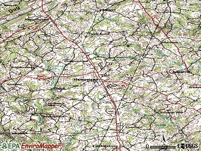
Points of interest:
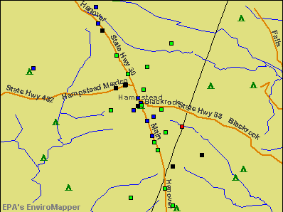
Notable locations in Hampstead: Hampstead North Business Center (A), Roberts Field Business Center (B), Oak Mont Green Golf Course (C), Carroll County Fire Department Hampstead Volunteer Company 2 (D), North Carroll Library (E). Display/hide their locations on the map
Churches in Hampstead include: Saint Johns United Methodist Church (A), Saint Mark Lutheran Church (B). Display/hide their locations on the map
Park in Hampstead: Hampstead Memorial Park (1). Display/hide its location on the map
Tourist attractions: Hampstead Train Station (Museums; 4035 Gill Avenue), Wildlife Rescue Inc (Recreation Areas; 19406 Grave Run Road).
Hotel: Albanstown Inn (18720 Brick Store Road).
Birthplace of: Charlie Snell - Baseball player.
Drinking water stations with addresses in Hampstead and their reported violations in the past:
TOWN OF HAMPSTEAD (Address: 1034 SOUTH CARROLL STREET , Population served: 6,400, Groundwater):Past monitoring violations:JOSEPH A. BANK CLOTHIER (Population served: 275, Groundwater):
- Monitoring and Reporting (DBP) - Between JAN-2010 and DEC-2010, Contaminant: Total Haloacetic Acids (HAA5). Follow-up actions: St Public Notif requested (FEB-10-2011), St Violation/Reminder Notice (FEB-10-2011), St Other (FEB-15-2011), St Compliance achieved (MAY-03-2011)
- Monitoring and Reporting (DBP) - Between JAN-2010 and DEC-2010, Contaminant: TTHM. Follow-up actions: St Public Notif requested (FEB-10-2011), St Violation/Reminder Notice (FEB-10-2011), St Other (FEB-15-2011), St Compliance achieved (MAY-03-2011)
Past health violations:SHILOH STEPPING STONES (Population served: 54, Groundwater):Past monitoring violations:
- MCL, Acute (TCR) - In AUG-2012, Contaminant: Coliform. Follow-up actions: St Violation/Reminder Notice (AUG-22-2012), St Public Notif requested (AUG-22-2012), St Public Notif received (AUG-29-2012), St Compliance achieved (SEP-10-2012)
- Follow-up Or Routine LCR Tap M/R - In JUL-01-2013, Contaminant: Lead and Copper Rule. Follow-up actions: St Violation/Reminder Notice (4 times from MAR-21-2013 to MAR-26-2014)
- Follow-up Or Routine LCR Tap M/R - In JUL-01-2010, Contaminant: Lead and Copper Rule. Follow-up actions: St Compliance achieved (SEP-15-2010)
- Water Quality Parameter M/R - Between JAN-2008 and DEC-2008, Contaminant: Lead and Copper Rule. Follow-up actions: St Compliance achieved (JAN-09-2009)
- Follow-up Or Routine LCR Tap M/R - In OCT-01-2007, Contaminant: Lead and Copper Rule. Follow-up actions: St Violation/Reminder Notice (SEP-11-2008), St Compliance achieved (OCT-14-2008)
- 6 routine major monitoring violations
- 3 regular monitoring violations
Past monitoring violations:UNITED COON CLUB HUNTERS ASSOCIATION (Address: 2855 COON CLUB ROAD , Population served: 50, Groundwater):
- Follow-up Or Routine LCR Tap M/R - In JAN-01-2014, Contaminant: Lead and Copper Rule. Follow-up actions: St Compliance achieved (JAN-15-2014)
Past health violations:CHARLES J. MILLER, LLC (Population served: 36, Groundwater):
- MCL, Monthly (TCR) - In JUN-2012, Contaminant: Coliform. Follow-up actions: St Violation/Reminder Notice (JUN-12-2012), St Tech Assistance Visit (JUN-15-2012), St Public Notif received (JUN-15-2012), St Tech Assistance Visit (2 times from OCT-19-2012 to OCT-19-2012), St Compliance achieved (NOV-01-2012)
- MCL, Acute (TCR) - In JUN-2012, Contaminant: Coliform. Follow-up actions: St Public Notif received (JUN-12-2012), St Violation/Reminder Notice (JUN-12-2012), St Compliance achieved (NOV-01-2012)
- MCL, Monthly (TCR) - In SEP-2009, Contaminant: Coliform. Follow-up actions: St Violation/Reminder Notice (SEP-21-2009), St Compliance achieved (JUN-18-2010)
- MCL, Acute (TCR) - In SEP-2009, Contaminant: Coliform. Follow-up actions: St Tech Assistance Visit (SEP-21-2009), St Violation/Reminder Notice (SEP-21-2009), St Compliance achieved (OCT-31-2009)
Past monitoring violations:
- Monitoring and Reporting (DBP) - Between JAN-2013 and MAR-2013, Contaminant: Chlorine. Follow-up actions: St Violation/Reminder Notice (JUN-07-2013), St Compliance achieved (JUN-19-2013)
- Monitoring and Reporting (DBP) - Between OCT-2012 and DEC-2012, Contaminant: Chlorine. Follow-up actions: St Violation/Reminder Notice (JUN-07-2013), St Compliance achieved (JUN-19-2013)
- 5 routine major monitoring violations
- 10 regular monitoring violations
| This town: | 2.6 people |
| Maryland: | 2.6 people |
| This town: | 68.7% |
| Whole state: | 67.1% |
| This town: | 6.1% |
| Whole state: | 6.4% |
Likely homosexual households (counted as self-reported same-sex unmarried-partner households)
- Lesbian couples: 0.3% of all households
- Gay men: 0.4% of all households
Banks with branches in Hampstead (2011 data):
- Farmers and Merchants Bank: Hampstead Branch at 735 Hanover Pike, branch established on 1990/04/23; Greenmount Branch at 2205 Hanover Pike, branch established on 1995/02/28. Info updated 2006/10/10: Bank assets: $253.9 mil, Deposits: $207.3 mil, headquarters in Upperco, MD, positive income, Commercial Lending Specialization, 7 total offices
- Manufacturers and Traders Trust Company: Hampstead Branch at 1200 North Main Street, branch established on 1900/06/15. Info updated 2011/08/08: Bank assets: $76,887.1 mil, Deposits: $60,064.2 mil, headquarters in Buffalo, NY, positive income, Commercial Lending Specialization, 808 total offices, Holding Company: M&T Bank Corporation
- New Windsor State Bank: North Carroll Branch at 2305 Hanover Pike, branch established on 2009/12/11. Info updated 2006/11/03: Bank assets: $262.6 mil, Deposits: $239.2 mil, headquarters in New Windsor, MD, negative income in the last year, Commercial Lending Specialization, 7 total offices, Holding Company: New Windsor Bancorp, Inc.
- PNC Bank, National Association: Hampstead Branch at 2325 Hanover Pike, branch established on 1986/12/22. Info updated 2012/03/20: Bank assets: $263,309.6 mil, Deposits: $197,343.0 mil, headquarters in Wilmington, DE, positive income, Commercial Lending Specialization, 3085 total offices, Holding Company: Pnc Financial Services Group, Inc., The
- Branch Banking and Trust Company: Hampstead Branch at 999 South Main Street, branch established on 1976/04/05. Info updated 2010/03/29: Bank assets: $168,867.6 mil, Deposits: $127,549.5 mil, headquarters in Winston Salem, NC, positive income, Commercial Lending Specialization, 1793 total offices, Holding Company: Bb&T Corporation
- Fraternity Federal Savings and Loan Association: 1631 N Main Street at 1631 N Main Street, branch established on 2009/09/28. Info updated 2012/04/04: Bank assets: $175.3 mil, Deposits: $128.3 mil, headquarters in Baltimore, MD, positive income, Mortgage Lending Specialization, 4 total offices
For population 15 years and over in Hampstead:
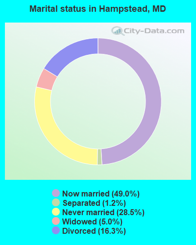
- Never married: 28.5%
- Now married: 49.0%
- Separated: 1.2%
- Widowed: 5.0%
- Divorced: 16.3%
For population 25 years and over in Hampstead:
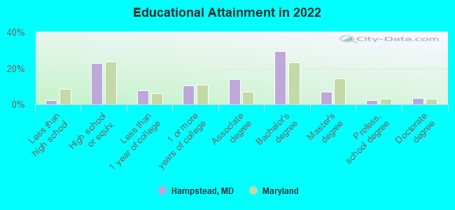
- High school or higher: 97.3%
- Bachelor's degree or higher: 41.1%
- Graduate or professional degree: 12.7%
- Unemployed: 1.0%
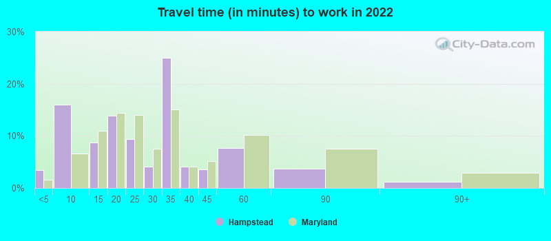
- Mean travel time to work (commute): 29.5 minutes
| Here: | 9.4 |
| Maryland average: | 12.7 |
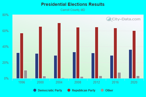
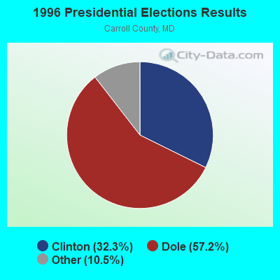
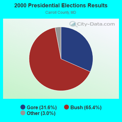


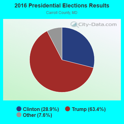
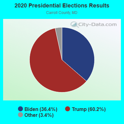
Graphs represent county-level data. Detailed 2008 Election Results
Religion statistics for Hampstead, MD (based on Carroll County data)
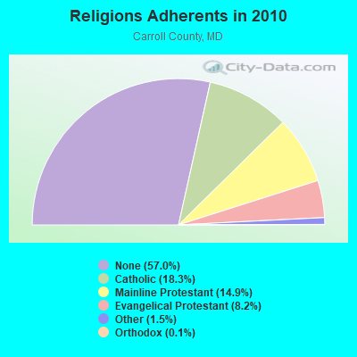
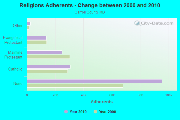
| Religion | Adherents | Congregations |
|---|---|---|
| Catholic | 30,551 | 4 |
| Mainline Protestant | 24,903 | 75 |
| Evangelical Protestant | 13,764 | 68 |
| Other | 2,472 | 9 |
| Orthodox | 226 | 2 |
| None | 95,218 | - |
Food Environment Statistics:
| Carroll County: | 1.18 / 10,000 pop. |
| Maryland: | 1.96 / 10,000 pop. |
| Carroll County: | 0.06 / 10,000 pop. |
| Maryland: | 0.07 / 10,000 pop. |
| This county: | 1.01 / 10,000 pop. |
| State: | 1.22 / 10,000 pop. |
| This county: | 1.84 / 10,000 pop. |
| Maryland: | 2.05 / 10,000 pop. |
| Carroll County: | 5.63 / 10,000 pop. |
| Maryland: | 5.40 / 10,000 pop. |
| Here: | 7.6% |
| Maryland: | 9.1% |
| Here: | 24.5% |
| Maryland: | 26.7% |
| This county: | 13.8% |
| State: | 15.5% |
Health and Nutrition:
| Here: | 58.1% |
| Maryland: | 50.1% |
| Here: | 60.8% |
| Maryland: | 47.6% |
| Hampstead: | 27.2 |
| State: | 28.8 |
| This city: | 18.9% |
| State: | 20.0% |
| Hampstead: | 6.9% |
| Maryland: | 11.3% |
| This city: | 7.0 |
| Maryland: | 6.8 |
| Hampstead: | 29.0% |
| State: | 34.1% |
| Hampstead: | 67.0% |
| Maryland: | 56.5% |
| Hampstead: | 84.9% |
| Maryland: | 80.5% |
More about Health and Nutrition of Hampstead, MD Residents
| Local government employment and payroll (March 2022) | |||||
| Function | Full-time employees | Monthly full-time payroll | Average yearly full-time wage | Part-time employees | Monthly part-time payroll |
|---|---|---|---|---|---|
| Police Protection - Officers | 10 | $60,590 | $72,708 | 0 | $0 |
| Water Supply | 8 | $47,514 | $71,271 | 1 | $3,100 |
| Other Government Administration | 4 | $23,440 | $70,320 | 0 | $0 |
| Police - Other | 1 | $3,984 | $47,808 | 0 | $0 |
| Financial Administration | 1 | $3,289 | $39,468 | 0 | $0 |
| Totals for Government | 24 | $138,817 | $69,409 | 1 | $3,100 |
Hampstead government finances - Expenditure in 2017 (per resident):
- Current Operations - Water Utilities: $931,000 ($146.80)
Police Protection: $843,000 ($132.92)
General - Other: $540,000 ($85.15)
Regular Highways: $416,000 ($65.59)
Solid Waste Management: $363,000 ($57.24)
Financial Administration: $149,000 ($23.49)
Parks and Recreation: $98,000 ($15.45)
General Public Buildings: $34,000 ($5.36)
Central Staff Services: $27,000 ($4.26)
Judicial and Legal Services: $24,000 ($3.78)
- General - Interest on Debt: $122,000 ($19.24)
- Other Capital Outlay - Police Protection: $296,000 ($46.67)
Regular Highways: $200,000 ($31.54)
- Total Salaries and Wages: $1,278,000 ($201.51)
Hampstead government finances - Revenue in 2017 (per resident):
- Charges - Other: $49,000 ($7.73)
- Local Intergovernmental - Highways: $3,000 ($0.47)
- Miscellaneous - General Revenue - Other: $245,000 ($38.63)
Interest Earnings: $28,000 ($4.42)
Sale of Property: $4,000 ($0.63)
Rents: $2,000 ($0.32)
- Revenue - Water Utilities: $1,023,000 ($161.31)
- State Intergovernmental - Highways: $171,000 ($26.96)
Other: $152,000 ($23.97)
- Tax - Property: $1,334,000 ($210.34)
Individual Income: $854,000 ($134.66)
Public Utility License: $46,000 ($7.25)
Amusements Sales: $37,000 ($5.83)
Other License: $11,000 ($1.73)
Occupation and Business License - Other: $6,000 ($0.95)
Alcoholic Beverage License: $3,000 ($0.47)
Hampstead government finances - Debt in 2017 (per resident):
- Long Term Debt - Outstanding Unspecified Public Purpose: $3,617,000 ($570.32)
Beginning Outstanding - Unspecified Public Purpose: $3,229,000 ($509.15)
Issue, Unspecified Public Purpose: $614,000 ($96.81)
Retired Unspecified Public Purpose: $227,000 ($35.79)
Hampstead government finances - Cash and Securities in 2017 (per resident):
- Other Funds - Cash and Securities: $2,059,000 ($324.66)
6.27% of this county's 2020 resident taxpayers moved to other counties in 2021 ($82,015 average adjusted gross income)
| Here: | 6.27% |
| Maryland average: | 7.91% |
0.03% of residents moved to foreign countries ($566 average AGI)
Carroll County: 0.03% Maryland average: 0.04%
Top counties to which taxpayers relocated from this county between 2020 and 2021:
| to Baltimore County, MD | |
| to Frederick County, MD | |
| to York County, PA |
| Businesses in Hampstead, MD | ||||
| Name | Count | Name | Count | |
|---|---|---|---|---|
| 7-Eleven | 1 | McDonald's | 1 | |
| Advance Auto Parts | 1 | Papa John's Pizza | 1 | |
| Burger King | 1 | Pizza Hut | 1 | |
| CVS | 1 | Quiznos | 1 | |
| Curves | 1 | RadioShack | 1 | |
| Domino's Pizza | 1 | T-Mobile | 1 | |
| Dunkin Donuts | 1 | Taco Bell | 1 | |
| FedEx | 2 | True Value | 1 | |
| GameStop | 1 | U-Haul | 2 | |
| H&R Block | 1 | UPS | 2 | |
| JoS. A. Bank | 1 | Walmart | 1 | |
| KFC | 1 | Wendy's | 1 | |
| MasterBrand Cabinets | 2 | |||
Strongest AM radio stations in Hampstead:
- WCBM (680 AM; 50 kW; BALTIMORE, MD; Owner: WCBM MARYLAND, INC.)
- WBAL (1090 AM; 50 kW; BALTIMORE, MD; Owner: HEARST RADIO, INC.)
- WGOP (700 AM; daytime; 25 kW; WALKERSVILLE, MD; Owner: BIRACH BROADCASTING CORPORATION)
- WWLG (1370 AM; 50 kW; BALTIMORE, MD; Owner: M-10 BROADCASTING, INC.)
- WCAO (600 AM; 5 kW; BALTIMORE, MD; Owner: CITICASTERS LICENSES, L.P.)
- WMET (1150 AM; 50 kW; GAITHERSBURG, MD; Owner: BELTWAY ACQUISITION CORPORATION)
- WTEM (980 AM; 50 kW; WASHINGTON, DC; Owner: AMFM RADIO LICENSES, L.L.C.)
- WTOP (1500 AM; 50 kW; WASHINGTON, DC; Owner: BONNEVILLE HOLDING COMPANY)
- WBIS (1190 AM; 50 kW; ANNAPOLIS, MD; Owner: NATIONS RADIO, LLC)
- WHVR (1280 AM; 5 kW; HANOVER, PA)
- WPGC (1580 AM; 50 kW; MORNINGSIDE, MD; Owner: INFINITY WPGC(AM), INC.)
- WVCH (740 AM; 50 kW; CHESTER, PA; Owner: WVCH COMMUNICATIONS, INC.)
- WJFK (1300 AM; 5 kW; BALTIMORE, MD; Owner: INFINITY WLIF-AM, INC.)
Strongest FM radio stations in Hampstead:
- WZBA (100.7 FM; WESTMINSTER, MD; Owner: SHAMROCK COMMUNICATIONS, INC.)
- WWMX (106.5 FM; BALTIMORE, MD; Owner: INFINITY RADIO OPERATIONS INC.)
- WYCR (98.5 FM; YORK-HANOVER, PA; Owner: RADIO HANOVER, INC.)
- WGTY (107.7 FM; GETTYSBURG, PA; Owner: TIMES AND NEWS PUBLISHING COMPANY)
- WLIF (101.9 FM; BALTIMORE, MD; Owner: INFINITY WLIF, INC.)
- WIYY (97.9 FM; BALTIMORE, MD; Owner: HEARST RADIO, INC.)
- WPOC (93.1 FM; BALTIMORE, MD; Owner: CITICASTERS LICENSES, L.P.)
- WSOX (96.1 FM; RED LION, PA; Owner: LANCASTER-YORK BROADCASTING, LLC)
- WROZ (101.3 FM; LANCASTER, PA; Owner: HALL COMMUNICATIONS, INC.)
- WARM-FM (103.3 FM; YORK, PA; Owner: WSBA LICO, INC.)
- WAYZ-FM (104.7 FM; HAGERSTOWN, MD; Owner: HJV LIMITED PARTNERSHIP)
- WBJC (91.5 FM; BALTIMORE, MD; Owner: BALTIMORE CITY COMMUNITY COLLEGE)
- WETH (89.1 FM; HAGERSTOWN, MD; Owner: GREATER WASHINGTON EDUCATIONAL TELECOMMUNICATIONS ASSN.)
- WQSR (102.7 FM; BALTIMORE, MD; Owner: INFINITY OF CHESAPEAKE LICENSEE CORP.)
- WFRE (99.9 FM; FREDERICK, MD; Owner: CAPSTAR TX LIMITED PARTNERSHIP)
- WERQ-FM (92.3 FM; BALTIMORE, MD; Owner: RADIO ONE LICENSES, LLC)
- W219BX (91.7 FM; FREDERICK, MD; Owner: CEDAR RIDGE CHILDREN'S HOME & SCHOOL, INC)
- WHBO (92.7 FM; STARVIEW, PA; Owner: HALL COMMUNICATIONS, INC.)
- WQXA-FM (105.7 FM; YORK, PA; Owner: CITADEL BROADCASTING COMPANY)
- WWVZ (103.9 FM; BRADDOCK HEIGHTS, MD; Owner: BONNEVILLE HOLDING COMPANY)
TV broadcast stations around Hampstead:
- WMPB (Channel 67; BALTIMORE, MD; Owner: MARYLAND PUBLIC BROADCASTING COMMISSION)
- WBAL-TV (Channel 11; BALTIMORE, MD; Owner: WBAL HEARST-ARGYLE TV, INC. (CA CORP.))
- WMAR-TV (Channel 2; BALTIMORE, MD; Owner: SCRIPPS HOWARD BROADCASTING COMPANY)
- WBFF (Channel 45; BALTIMORE, MD; Owner: CHESAPEAKE TELEVISION LICENSEE, LLC)
- WNUV (Channel 54; BALTIMORE, MD; Owner: BALTIMORE (WNUV-TV) LICENSEE, INC.)
- WJZ-TV (Channel 13; BALTIMORE, MD; Owner: VIACOM INC.)
- WUTB (Channel 24; BALTIMORE, MD; Owner: FOX TELEVISION STATIONS, INC.)
- WPMT (Channel 43; YORK, PA; Owner: TRIBUNE TELEVISION COMPANY)
- WGAL (Channel 8; LANCASTER, PA; Owner: WGAL HEARST-ARGYLE TELEVISION, INC.)
- WGCB-TV (Channel 49; RED LION, PA; Owner: RED LION BROADCASTING CO., INC.)
- W23AY (Channel 23; YORK, PA; Owner: WIRELESS CABLE TV OF PA, INC.)
- National Bridge Inventory (NBI) Statistics
- 31Number of bridges
- 138ft / 41.8mTotal length
- $323,000Total costs
- 82,450Total average daily traffic
- 5,316Total average daily truck traffic
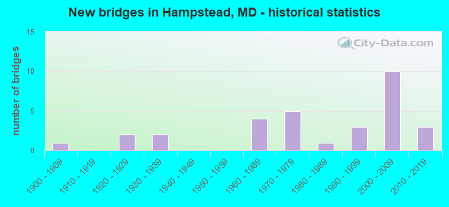
- New bridges - historical statistics
- 11900-1909
- 21920-1929
- 21930-1939
- 41960-1969
- 51970-1979
- 11980-1989
- 31990-1999
- 102000-2009
- 32010-2019
FCC Registered Antenna Towers:
34 (See the full list of FCC Registered Antenna Towers in Hampstead)FCC Registered Broadcast Land Mobile Towers:
6- 1552 N Main St (Lat: 39.616389 Lon: -76.860278), Type: Tower, Structure height: 219.8 m, Overall height: 220.7 m, Call Sign: WNSK754,
Assigned Frequencies: 856.862 MHz, Grant Date: 06/01/2023, Expiration Date: 06/17/2033, Certifier: Albert J Slack, Registrant: Keller And Heckman LLP, 1001 G Street Nw, Suite 500, Washington, DC 20001, Phone: (202) 434-4100, Fax: (202) 434-4646, Email:
- 334 Lees Mill Rd (Lat: 39.565944 Lon: -76.855250), Call Sign: KZT663, Licensee ID: L00049002,
Assigned Frequencies: 31.6400 MHz, Grant Date: 03/22/2001, Expiration Date: 03/07/2011, Cancellation Date: 05/07/2011, Registrant: Lippy Brothers Inc, 334 Lees Mill Rd, Hampstead, MD 21074, Phone: (301) 374-9708
- Lat: 39.612722 Lon: -76.854139, Call Sign: WPVA895,
Assigned Frequencies: 464.325 MHz, 464.762 MHz, Grant Date: 06/10/2002, Expiration Date: 06/10/2012, Cancellation Date: 08/11/2012, Certifier: Gary Beck Mr., Registrant: Mills\' Communications Inc, 210 Pennsylvania Ave, Westminster, MD 21157, Phone: (410) 876-8600, Fax: (410) 857-1225
- Lat: 39.646389 Lon: -76.828889, Call Sign: WPXL539,
Assigned Frequencies: 451.325 MHz, 452.150 MHz, 452.225 MHz, 463.575 MHz, 463.725 MHz, Grant Date: 04/29/2003, Expiration Date: 04/29/2013, Cancellation Date: 06/29/2013, Certifier: Jim Masimore, Registrant: North Carroll Comm, 219 Greenwood Ave, Westminster, MD 21157, Phone: (410) 876-1188
- Lat: 39.612722 Lon: -76.854139, Call Sign: WQPB341,
Assigned Frequencies: 462.337 MHz, 467.337 MHz, Grant Date: 02/10/2022, Expiration Date: 03/27/2032, Certifier: Evan Fogarty, Registrant: Mills\' Communications Inc., 700 M Corporate Center Ct, Westminster, MD 21157, Phone: (410) 876-8600, Fax: (410) 857-1225, Email:
- PLANT, 626 Hanover Pike (Lat: 39.593583 Lon: -76.847000), Call Sign: WQWY388,
Assigned Frequencies: 451.187 MHz, 451.362 MHz, 452.712 MHz, 452.087 MHz, 452.487 MHz, 456.187 MHz, 456.362 MHz, 457.712 MHz, 457.087 MHz, 457.487 MHz, Grant Date: 12/24/2015, Expiration Date: 12/24/2025, Certifier: Jonathan Manger, Registrant: Mills\' Communications, Inc., 210 Pennsylvania Ave., Westminster, MD 21157-4343, Phone: (410) 876-8600, Fax: (410) 857-1225, Email:
FCC Registered Microwave Towers:
11 (See the full list of FCC Registered Microwave Towers in this town)FCC Registered Paging Towers:
2 (See the full list of FCC Registered Paging Towers)FCC Registered Amateur Radio Licenses:
87 (See the full list of FCC Registered Amateur Radio Licenses in Hampstead)FAA Registered Aircraft:
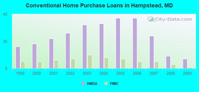
10 (See the full list of FAA Registered Aircraft in Hampstead)| Home Mortgage Disclosure Act Aggregated Statistics For Year 2009 (Based on 1 partial tract) | ||||||||||||
| A) FHA, FSA/RHS & VA Home Purchase Loans | B) Conventional Home Purchase Loans | C) Refinancings | D) Home Improvement Loans | F) Non-occupant Loans on < 5 Family Dwellings (A B C & D) | G) Loans On Manufactured Home Dwelling (A B C & D) | |||||||
|---|---|---|---|---|---|---|---|---|---|---|---|---|
| Number | Average Value | Number | Average Value | Number | Average Value | Number | Average Value | Number | Average Value | Number | Average Value | |
| LOANS ORIGINATED | 10 | $224,164 | 7 | $209,557 | 48 | $216,474 | 2 | $125,325 | 2 | $205,300 | 0 | $0 |
| APPLICATIONS APPROVED, NOT ACCEPTED | 0 | $0 | 0 | $0 | 4 | $217,628 | 1 | $35,300 | 0 | $0 | 0 | $0 |
| APPLICATIONS DENIED | 1 | $358,740 | 1 | $72,290 | 11 | $232,729 | 1 | $52,190 | 0 | $0 | 1 | $27,870 |
| APPLICATIONS WITHDRAWN | 0 | $0 | 1 | $195,760 | 10 | $223,032 | 0 | $0 | 0 | $0 | 0 | $0 |
| FILES CLOSED FOR INCOMPLETENESS | 0 | $0 | 0 | $0 | 3 | $192,547 | 0 | $0 | 0 | $0 | 0 | $0 |
Detailed HMDA statistics for the following Tracts: 5081.00
| Private Mortgage Insurance Companies Aggregated Statistics For Year 2009 (Based on 1 partial tract) | ||||
| A) Conventional Home Purchase Loans | B) Refinancings | |||
|---|---|---|---|---|
| Number | Average Value | Number | Average Value | |
| LOANS ORIGINATED | 1 | $300,470 | 1 | $277,000 |
| APPLICATIONS APPROVED, NOT ACCEPTED | 0 | $0 | 1 | $283,920 |
| APPLICATIONS DENIED | 0 | $0 | 0 | $0 |
| APPLICATIONS WITHDRAWN | 0 | $0 | 0 | $0 |
| FILES CLOSED FOR INCOMPLETENESS | 0 | $0 | 0 | $0 |
Detailed PMIC statistics for the following Tracts: 5081.00

2002 - 2018 National Fire Incident Reporting System (NFIRS) incidents
- Fire incident types reported to NFIRS in Hampstead, MD
- 48251.0%Structure Fires
- 29831.5%Outside Fires
- 848.9%Other
- 828.7%Mobile Property/Vehicle Fires
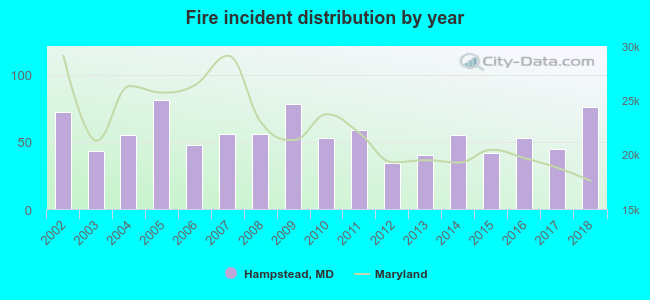 According to the data from the years 2002 - 2018 the average number of fires per year is 56. The highest number of fires - 81 took place in 2005, and the least - 34 in 2012. The data has a growing trend.
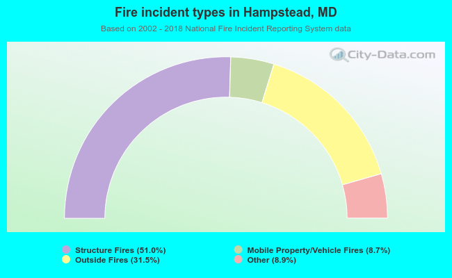 When looking into fire subcategories, the most reports belonged to: Structure Fires (51.0%), and Outside Fires (31.5%).
| Most common first names in Hampstead, MD among deceased individuals | ||
| Name | Count | Lived (average) |
|---|---|---|
| William | 90 | 72.7 years |
| George | 70 | 74.3 years |
| John | 67 | 74.8 years |
| Charles | 67 | 75.1 years |
| Mary | 60 | 81.5 years |
| Robert | 50 | 74.1 years |
| Helen | 40 | 79.4 years |
| Margaret | 37 | 80.2 years |
| James | 37 | 73.1 years |
| Ruth | 33 | 79.2 years |
| Most common last names in Hampstead, MD among deceased individuals | ||
| Last name | Count | Lived (average) |
|---|---|---|
| Martin | 39 | 79.5 years |
| Miller | 34 | 80.0 years |
| Rill | 32 | 79.2 years |
| Smith | 25 | 75.4 years |
| Snyder | 22 | 81.7 years |
| Ruby | 21 | 76.7 years |
| Harris | 19 | 73.0 years |
| Myers | 16 | 76.2 years |
| Armacost | 16 | 80.8 years |
| Reed | 14 | 78.0 years |

- 53.4%Electricity
- 40.4%Utility gas
- 3.6%Fuel oil, kerosene, etc.
- 1.0%Bottled, tank, or LP gas
- 1.0%No fuel used
- 0.5%Wood
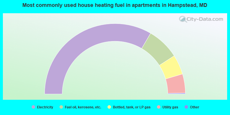
- 67.1%Electricity
- 14.9%Fuel oil, kerosene, etc.
- 9.1%Bottled, tank, or LP gas
- 8.8%Utility gas
Hampstead compared to Maryland state average:
- Unemployed percentage significantly below state average.
- Black race population percentage significantly below state average.
- Hispanic race population percentage significantly below state average.
- Foreign-born population percentage significantly below state average.
- Length of stay since moving in significantly above state average.
Hampstead on our top lists:
- #17 on the list of "Top 101 cities with largest percentage of females in occupations: management occupations (population 5,000+)"
- #74 on the list of "Top 101 cities with the most residents born in Other Western Asia (population 500+)"
- #17 on the list of "Top 101 counties with the largest decrease in the number of births per 1000 residents 2000-2006 to 2007-2013 (pop 50,000+)"
- #29 on the list of "Top 101 counties with the lowest average weight of females"
- #36 on the list of "Top 101 counties with the lowest percentage of residents that exercised in the past month"
- #53 on the list of "Top 101 counties with the lowest number of births per 1000 residents 2007-2013"
- #58 on the list of "Top 101 counties with the highest percentage of residents that visited a dentist within the past year"

|
|
Total of 121 patent applications in 2008-2024.