Hartford, Tennessee

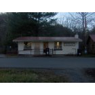

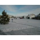
Submit your own pictures of this place and show them to the world
- OSM Map
- General Map
- Google Map
- MSN Map

| Males: 1,991 | |
| Females: 2,095 |
| Median resident age: | 38.6 years |
| Tennessee median age: | 35.9 years |
Zip code: 37722
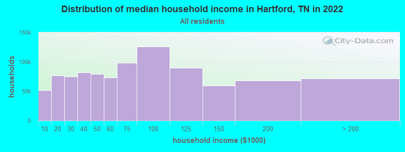
| Hartford: | $43,709 |
| TN: | $65,254 |
Estimated per capita income in 2022: $24,329 (it was $12,821 in 2000)
Hartford CCD income, earnings, and wages data
Estimated median house or condo value in 2022: $168,107 (it was $63,300 in 2000)
| Hartford: | $168,107 |
| TN: | $284,800 |
Detailed information about poverty and poor residents in Hartford, TN


- 3,77797.3%White alone
- 501.3%Hispanic
- 260.7%Two or more races
- 110.3%Black alone
- 110.3%American Indian alone
- 50.1%Other race alone
- 30.08%Asian alone
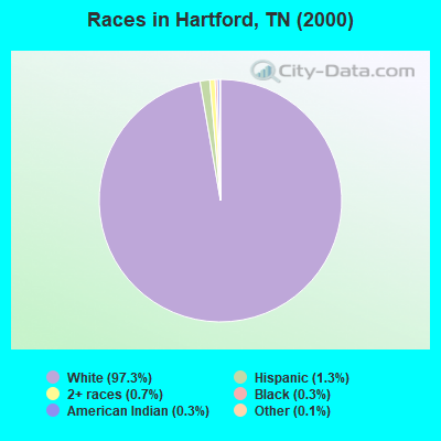
Races in Hartford detailed stats: ancestries, foreign born residents, place of birth
According to our research of Tennessee and other state lists, there were 5 registered sex offenders living in Hartford, Tennessee as of May 15, 2024.
The ratio of all residents to sex offenders in Hartford is 817 to 1.
The ratio of registered sex offenders to all residents in this city is lower than the state average.
 Recent articles from our blog. Our writers, many of them Ph.D. graduates or candidates, create easy-to-read articles on a wide variety of topics.
Hartford, TN City Guides:
Current Local Time: EST time zone
Elevation: 1260 feet
Land area: 87.4 square miles.
Population density: 47 people per square mile (very low).

| Hartford CCD: | 0.6% ($368) |
| Tennessee: | 0.8% ($715) |
Nearest city with pop. 50,000+: Asheville, NC  (38.6 miles , pop. 68,889).
Nearest city with pop. 200,000+: Charlotte, NC (138.9 miles , pop. 540,828).
Nearest city with pop. 1,000,000+: Chicago, IL (482.5 miles , pop. 2,896,016).
Nearest cities:
), ), ), ), ), )Latitude: 35.81 N, Longitude: 83.18 W

| Here: | 3.6% |
| Tennessee: | 3.0% |
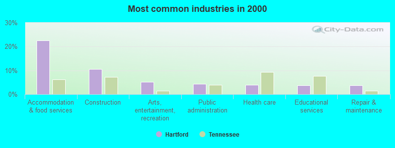
- Accommodation & food services (22.6%)
- Construction (10.5%)
- Arts, entertainment, recreation (5.1%)
- Public administration (4.4%)
- Health care (3.8%)
- Educational services (3.7%)
- Repair & maintenance (3.7%)
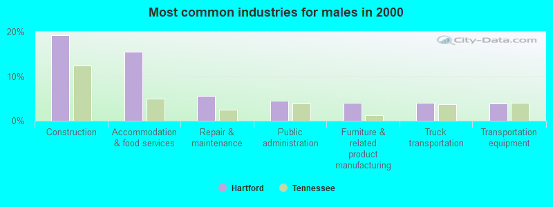
- Construction (19.2%)
- Accommodation & food services (15.5%)
- Repair & maintenance (5.6%)
- Public administration (4.5%)
- Furniture & related product manufacturing (4.0%)
- Truck transportation (4.0%)
- Transportation equipment (3.9%)
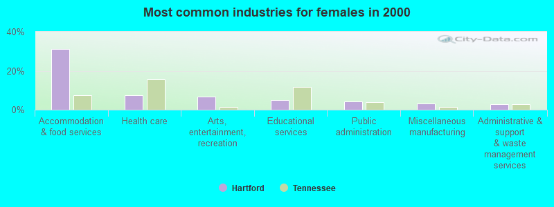
- Accommodation & food services (31.3%)
- Health care (7.4%)
- Arts, entertainment, recreation (6.6%)
- Educational services (5.1%)
- Public administration (4.3%)
- Miscellaneous manufacturing (3.2%)
- Administrative & support & waste management services (3.0%)
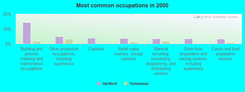
- Building and grounds cleaning and maintenance occupations (14.4%)
- Other production occupations, including supervisors (5.0%)
- Cashiers (4.0%)
- Retail sales workers, except cashiers (3.8%)
- Material recording, scheduling, dispatching, and distributing workers (3.6%)
- Other food preparation and serving workers, including supervisors (3.5%)
- Cooks and food preparation workers (3.3%)
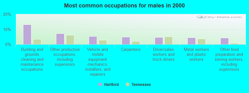
- Building and grounds cleaning and maintenance occupations (13.2%)
- Other production occupations, including supervisors (7.1%)
- Vehicle and mobile equipment mechanics, installers, and repairers (5.4%)
- Carpenters (4.9%)
- Driver/sales workers and truck drivers (4.8%)
- Metal workers and plastic workers (4.6%)
- Other food preparation and serving workers, including supervisors (4.4%)
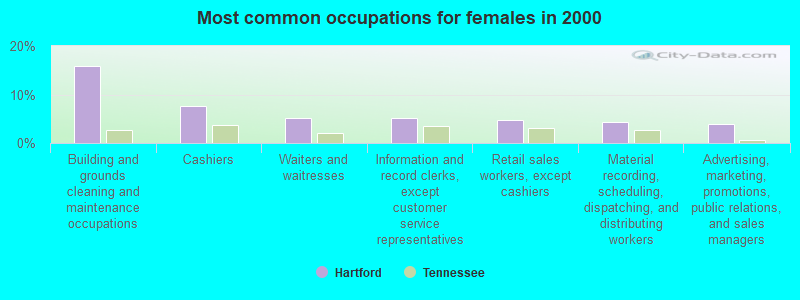
- Building and grounds cleaning and maintenance occupations (15.9%)
- Cashiers (7.7%)
- Waiters and waitresses (5.3%)
- Information and record clerks, except customer service representatives (5.1%)
- Retail sales workers, except cashiers (4.7%)
- Material recording, scheduling, dispatching, and distributing workers (4.3%)
- Advertising, marketing, promotions, public relations, and sales managers (3.9%)
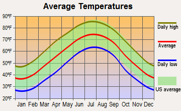
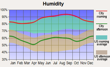
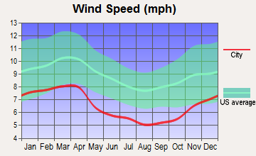
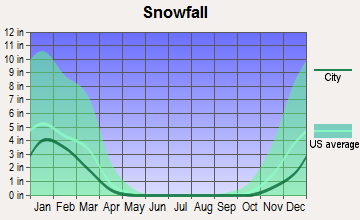
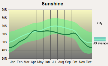
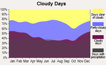
Average climate in Hartford, Tennessee
Based on data reported by over 4,000 weather stations
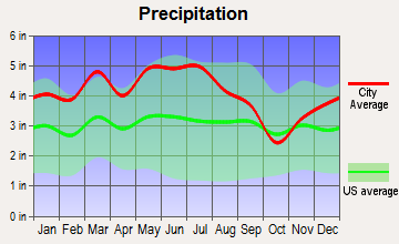
(lower is better)
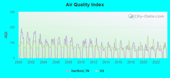
Air Quality Index (AQI) level in 2022 was 60.5. This is about average.
| City: | 60.5 |
| U.S.: | 72.6 |
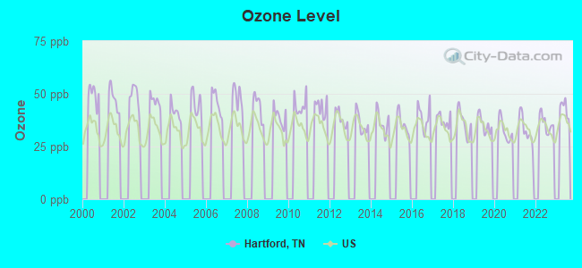
Ozone [ppb] level in 2022 was 35.9. This is about average. Closest monitor was 16.3 miles away from the city center.
| City: | 35.9 |
| U.S.: | 33.3 |
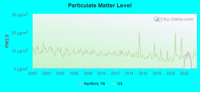
Particulate Matter (PM2.5) [µg/m3] level in 2022 was 6.71. This is better than average. Closest monitor was 22.4 miles away from the city center.
| City: | 6.71 |
| U.S.: | 8.11 |
Tornado activity:
Hartford-area historical tornado activity is significantly below Tennessee state average. It is 53% smaller than the overall U.S. average.
On 2/18/1976, a category F2 (max. wind speeds 113-157 mph) tornado 10.2 miles away from the Hartford place center injured 10 people and caused between $500,000 and $5,000,000 in damages.
On 3/11/1963, a category F2 tornado 13.9 miles away from the place center killed one person and injured one person and caused between $50,000 and $500,000 in damages.
Earthquake activity:
Hartford-area historical earthquake activity is significantly above Tennessee state average. It is 50% greater than the overall U.S. average.On 8/9/2020 at 12:07:37, a magnitude 5.1 (5.1 MW, Depth: 4.7 mi, Class: Moderate, Intensity: VI - VII) earthquake occurred 125.6 miles away from the city center
On 11/30/1973 at 07:48:41, a magnitude 4.7 (4.7 MB, 4.6 ML, Class: Light, Intensity: IV - V) earthquake occurred 43.7 miles away from Hartford center
On 7/27/1980 at 18:52:21, a magnitude 5.2 (5.1 MB, 4.7 MS, 5.0 UK, 5.2 UK) earthquake occurred 171.2 miles away from the city center
On 8/2/1974 at 08:52:09, a magnitude 4.9 (4.3 MB, 4.9 LG) earthquake occurred 139.4 miles away from Hartford center
On 8/23/2011 at 17:51:04, a magnitude 5.8 (5.8 MW, Depth: 3.7 mi) earthquake occurred 324.8 miles away from the city center
On 4/29/2003 at 08:59:39, a magnitude 4.9 (4.4 MB, 4.6 MW, 4.9 LG) earthquake occurred 165.4 miles away from Hartford center
Magnitude types: regional Lg-wave magnitude (LG), body-wave magnitude (MB), local magnitude (ML), surface-wave magnitude (MS), moment magnitude (MW)
Natural disasters:
The number of natural disasters in Cocke County (17) is near the US average (15).Major Disasters (Presidential) Declared: 13
Emergencies Declared: 2
Causes of natural disasters: Floods: 13, Storms: 10, Heavy Rains: 3, Tornadoes: 2, Winter Storms: 2, Flash Flood: 1, Hurricane: 1, Landslide: 1, Mudslide: 1, Snowfall: 1, Wind: 1, Other: 1 (Note: some incidents may be assigned to more than one category).
Hospitals and medical centers near Hartford:
- SMOKY MOUNTAIN HOME HEALTH AND HOSPICE, INC (Home Health Center, about 10 miles away; NEWPORT, TN)
- SMOKY MOUNTAIN HOSPICE INC (Hospital, about 10 miles away; NEWPORT, TN)
- BAPTIST CONVALESCENT CENTER (Nursing Home, about 12 miles away; NEWPORT, TN)
- TENNOVA HEALTHCARE-NEWPORT MEDICAL CENTER Acute Care Hospitals (about 12 miles away; NEWPORT, TN)
- FMC DIALYSIS NEWPORT (Dialysis Facility, about 12 miles away; NEWPORT, TN)
- VIP HOME NURSING REHAB SERVICE INC (Home Health Center, about 12 miles away; NEWPORT, TN)
- NEWPORT HEALTH AND REHABILITATION CENTER (Nursing Home, about 13 miles away; NEWPORT, TN)
Colleges/universities with over 2000 students nearest to Hartford:
- Walters State Community College (about 29 miles; Morristown, TN; Full-time enrollment: 4,359)
- Tusculum College (about 35 miles; Greeneville, TN; FT enrollment: 2,070)
- Western Carolina University (about 37 miles; Cullowhee, NC; FT enrollment: 8,684)
- University of North Carolina at Asheville (about 38 miles; Asheville, NC; FT enrollment: 3,312)
- Asheville-Buncombe Technical Community College (about 39 miles; Asheville, NC; FT enrollment: 6,992)
- The University of Tennessee-Knoxville (about 44 miles; Knoxville, TN; FT enrollment: 25,483)
- Pellissippi State Community College (about 56 miles; Knoxville, TN; FT enrollment: 7,271)
Public elementary/middle school in Hartford:
- GRASSY FORK ELEMENTARY (Students: 121, Location: 4120 BIG CREEK RD, Grades: KG-8)
Points of interest:
Notable locations in Hartford: Snakeden Mountain Campsite (A), Cosby Ranger Station (B), Dayenport Gap Appalachian Trail Shelter (C), Davenport Gap Appalachian Trail Shelter (D), Kyle Carver Orchards (E), Gilliland Creek Campsite (F), Otter Creek Campsite (G), Sugar Cove Campsite (H), Cosby Volunteer Fire Department Station 2 (I), Cosby Volunteer Fire Department Station 1 (J), Davenport Gap Shelter (K), Grassy Fork Volunteer Fire Department (L). Display/hide their locations on the map
Churches in Hartford include: Catons Grove Methodist Church (A), New Prospect Baptist Church (B), Laurel Spring Church (C), Andrews Chapel (D), Browns Baptist Church (E), Allen Grove Church (F), McMillan Church (G), Moraine Seminary Church (H), Ogle Chapel (I). Display/hide their locations on the map
Cemeteries: Johnson Cemetery (1), Mack Cemetery (2), Gunter Cemetery (3), Campbell Cemetery (4), Abe Cemetery (5), Valentine Cemetery (6), Tritt Cemetery (7). Display/hide their locations on the map
Streams, rivers, and creeks: Maddron Creek (A), Long Branch (B), Indian Camp Creek (C), Jones Branch (D), Shoestring Branch (E), Stillhouse Branch (F), Tinker Branch (G), Toms Creek (H), Turnalay Creek (I). Display/hide their locations on the map
Drinking water stations with addresses in Hartford that have no violations reported:
- HARTFORD WELCOME CENTER (Population served: 1,001, Primary Water Source Type: Groundwater)
| This place: | 2.5 people |
| Tennessee: | 2.5 people |
| This place: | 61.8% |
| Whole state: | 69.8% |
| This place: | 6.3% |
| Whole state: | 4.2% |
Likely homosexual households (counted as self-reported same-sex unmarried-partner households)
- Lesbian couples: 0.1% of all households
- Gay men: 0.6% of all households
| This place: | 22.4% |
| Whole state: | 13.5% |
| This place: | 4.3% |
| Whole state: | 5.8% |
For population 15 years and over in Hartford:
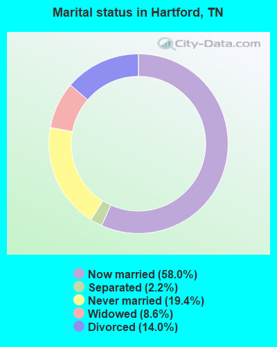
- Never married: 19.4%
- Now married: 58.0%
- Separated: 2.2%
- Widowed: 8.6%
- Divorced: 14.0%
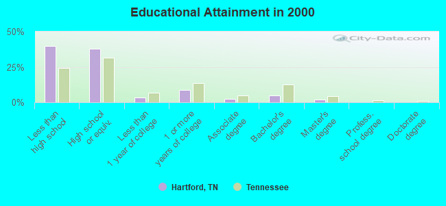
For population 25 years and over in Hartford:
- High school or higher: 60.0%
- Bachelor's degree or higher: 7.1%
- Graduate or professional degree: 2.5%
- Unemployed: 9.6%
- Mean travel time to work (commute): 32.4 minutes
| Here: | 16.4 |
| Tennessee average: | 13.3 |
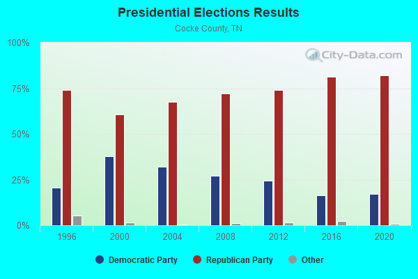
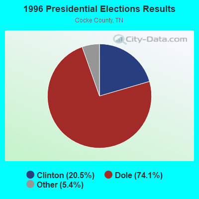
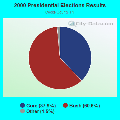
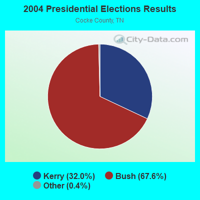
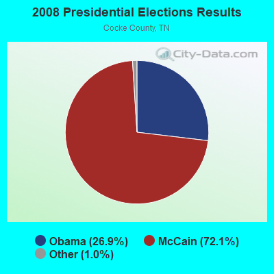
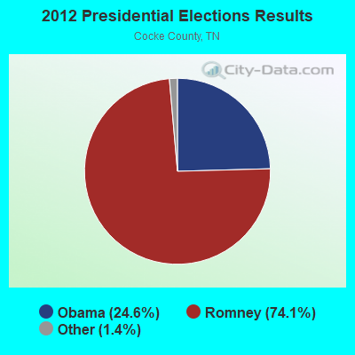
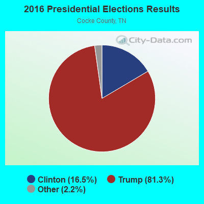
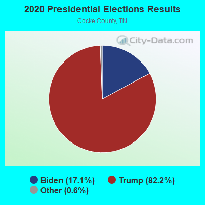
Graphs represent county-level data. Detailed 2008 Election Results
Religion statistics for Hartford, TN (based on Cocke County data)
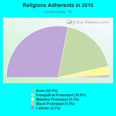
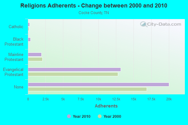
| Religion | Adherents | Congregations |
|---|---|---|
| Evangelical Protestant | 13,136 | 72 |
| Mainline Protestant | 1,900 | 18 |
| Black Protestant | 360 | 2 |
| Catholic | 240 | 1 |
| Other | 3 | 1 |
| None | 20,023 | - |
Food Environment Statistics:
| Cocke County: | 1.98 / 10,000 pop. |
| Tennessee: | 1.99 / 10,000 pop. |
| Cocke County: | 0.28 / 10,000 pop. |
| Tennessee: | 0.17 / 10,000 pop. |
| Cocke County: | 1.70 / 10,000 pop. |
| Tennessee: | 0.65 / 10,000 pop. |
| This county: | 7.65 / 10,000 pop. |
| State: | 5.16 / 10,000 pop. |
| Cocke County: | 6.80 / 10,000 pop. |
| Tennessee: | 6.56 / 10,000 pop. |
| This county: | 12.7% |
| State: | 11.4% |
| Cocke County: | 31.2% |
| Tennessee: | 30.2% |
| Cocke County: | 13.9% |
| State: | 13.5% |
Strongest AM radio stations in Hartford:
- WLIK (1270 AM; 5 kW; NEWPORT, TN; Owner: WLIK, INC)
- WKVL (850 AM; daytime; 50 kW; KNOXVILLE, TN; Owner: HORNE RADIO, LLC)
- WFGW (1010 AM; 50 kW; BLACK MOUNTAIN, NC; Owner: BLUE RIDGE BROADCASTING CORP.)
- WKJV (1380 AM; 25 kW; ASHEVILLE, NC; Owner: INTERNATIONAL BAPTIST OUTREACH MISSIONS)
- WLFJ (660 AM; daytime; 50 kW; GREENVILLE, SC; Owner: CLEAR CHANNEL BROADCASTING LICENSES, INC.)
- WSEV (930 AM; 5 kW; SEVIERVILLE, TN; Owner: EAST TENNESSEE RADIO GROUP, L.P.)
- WCSZ (1070 AM; 50 kW; SANS SOUCI, SC; Owner: WHYZ RADIO, L.P.)
- WOXL (970 AM; 5 kW; CANTON, NC; Owner: SAGA COMMUNICATIONS OF NORTH CAROLINA, LLC)
- WWNC (570 AM; 5 kW; ASHEVILLE, NC; Owner: CAPSTAR TX LIMITED PARTNERSHIP)
- WVLZ (1180 AM; daytime; 10 kW; KNOXVILLE, TN; Owner: KIRKLAND WIRELESS BROADCASTERS, INC.)
- WNPC (1060 AM; daytime; 1 kW; NEWPORT, TN; Owner: HARRIS BROADCASTING INCORPORATED)
- WGCR (720 AM; daytime; 10 kW; PISGAH FOREST, NC; Owner: ANCHOR BAPTIST BROADCASTING ASSOCIATION)
- WNOX (990 AM; 10 kW; KNOXVILLE, TN)
Strongest FM radio stations in Hartford:
- W237AR (95.3 FM; HAZELWOOD, ETC., NC; Owner: WESTERN NORTH CAROLINA PUBLIC RADIO)
- WNPC-FM (92.9 FM; NEWPORT, TN; Owner: HARRIS BROADCASTING INC DBA WNPC INC)
- WIVK-FM (107.7 FM; KNOXVILLE, TN; Owner: CITADEL BROADCASTING COMPANY)
- WQNS (104.9 FM; WAYNESVILLE, NC; Owner: CLEAR CHANNEL BROADCASTING LICENSES, INC.)
- WWST (102.1 FM; SEVIERVILLE, TN; Owner: JOURNAL BROADCAST CORPORATION)
- WKSF (99.9 FM; ASHEVILLE, NC; Owner: CAPSTAR TX LIMITED PARTNERSHIP)
- W220CD (91.9 FM; ENKA, NC; Owner: CALVARY CHAPEL OF TWIN FALLS, INC.)
- WMIT (106.9 FM; BLACK MOUNTAIN, NC; Owner: BLUE RIDGE BROADCASTING CORPORATION)
- WSEV-FM (105.5 FM; GATLINBURG, TN; Owner: EAST TENNESSEE RADIO GROUP, L.P.)
- WNCW (88.7 FM; SPINDALE, NC; Owner: ISOTHERMAL COMMUNITY COLLEGE)
- WIMZ-FM (103.5 FM; KNOXVILLE, TN; Owner: SOUTH CENTRAL COMM., CORP.)
- WFQS (91.3 FM; FRANKLIN, NC; Owner: WESTERN NORTH CAROLINA PUBLIC RADIO)
- WWCU (90.5 FM; CULLOWHEE, NC; Owner: WESTERN CAROLINA UNIVERSITY)
- WOKI-FM (100.3 FM; OAK RIDGE, TN; Owner: OAK RIDGE FM, INC.)
- WCQS (88.1 FM; ASHEVILLE, NC; Owner: WESTERN NORTH CAROLINA PUBLIC RADIO)
- WCVP-FM (95.9 FM; ROBBINSVILLE, NC; Owner: CHEROKEE BROADCASTING COMPANY, INC.)
- WNCC-FM (96.7 FM; FRANKLIN, NC; Owner: SUTTON RADIOCASTING CORPORATION)
- WAEZ (94.9 FM; GREENEVILLE, TN; Owner: BRISTOL BROADCASTING COMPANY, INC.)
- WUOT (91.9 FM; KNOXVILLE, TN; Owner: UNIVERSITY OF TENNESSEE)
- WTFM (98.5 FM; KINGSPORT, TN; Owner: HOLSTON VALLEY BROADCASTING CORP.)
TV broadcast stations around Hartford:
- WASV-TV (Channel 62; ASHEVILLE, NC; Owner: MEDIA GENERAL BROADCASTING OF SOUTH CAROLINA HOLDINGS, INC.)
- W50AB (Channel 50; HIAWASSEE, GA; Owner: GEORGIA PUBLIC TELECOMMUNICATIONS COMMISSION)
- WKOP-TV (Channel 15; KNOXVILLE, TN; Owner: EAST TENNESSEE PUBLIC COMMUNICATIONS CORP.)
- WVLT-TV (Channel 8; KNOXVILLE, TN; Owner: WVLT LICENSEE CORP.)
- WBIR-TV (Channel 10; KNOXVILLE, TN; Owner: GANNETT PACIFIC CORPORATION)
- WATE-TV (Channel 6; KNOXVILLE, TN; Owner: WATE, G.P.)
- W51CK (Channel 51; TALBERT, KY; Owner: MS COMMUNICATIONS, LLC)
- WTNZ (Channel 43; KNOXVILLE, TN; Owner: RAYCOM AMERICA, INC.)
- WHNS (Channel 21; ASHEVILLE, NC; Owner: MEREDITH CORPORATION)
- WJZC-LP (Channel 22; SEVIERVILLE, TN; Owner: SOUTH CENTRAL COMMUNICATIONS CORP.)
FCC Registered Antenna Towers:
2- Edward G Roach, 3552 Mill Creek Road (Tn04795-A) (Lat: 35.819333 Lon: -83.142667), Type: 97.5, Structure height: 47029 m, Overall height: 91.7 m, Registrant: Sba Properties, LLC, Eroach@sbasite.Com, , Boca -Raton, Phone: (561) 995-7670
- Edward G Roach, 3552 Mill Creek Road (Tn04795-A) (Lat: 35.819333 Lon: -83.142667), Type: 97.5, Structure height: 47029 m, Overall height: 91.7 m, Registrant: Sba Properties, LLC, Eroach@sbasite.Com, , Boca -Raton, Phone: (561) 995-7670
FCC Registered Broadcast Land Mobile Towers:
1- Hartford Mnws (Lat: 35.817500 Lon: -83.145000), Type: Pole, Structure height: 16 m, Call Sign: WPCH361,
Assigned Frequencies: 465.100 MHz, Grant Date: 04/11/2023, Expiration Date: 05/20/2033, Certifier: Richard A Donaldson, Registrant: Duke Energy Business Services, LLC, 9700 David Taylor Dr., Charlotte, NC 28262, Phone: (704) 382-4105, Email:
FCC Registered Paging Towers:
1- 1390 Ike Wright Road (Lat: 35.874444 Lon: -83.153889), Type: Upole, Structure height: 15 m, Call Sign: WPRT804,
Assigned Frequencies: 459.600 MHz, Grant Date: 01/25/2001, Expiration Date: 01/25/2011, Cancellation Date: 05/04/2006, Certifier: Stanley C Thompson, Registrant: Bellsouth Telecommunications, Inc, 22j64 Bsc 675 West Peachtree St, Ne, Atlanta, GA 30375, Phone: (404) 927-2692, Fax: (404) 522-7665, Email:
FCC Registered Amateur Radio Licenses:
3- Call Sign: KC4YXN, Grant Date: 04/09/1991, Expiration Date: 04/09/2001, Cancellation Date: 04/10/2003, Registrant: William F Ball, Rt 1 Box 61, Hartford, TN 37753
- Call Sign: KE4BEJ, Licensee ID: L00691435, Grant Date: 08/08/2003, Expiration Date: 08/17/2013, Cancellation Date: 08/18/2015, Registrant: Dawn C Carter, 3770 Trail Hollow Road, Hartford, TN 37753
- Call Sign: KM4WKR, Licensee ID: L02048977, Grant Date: 08/31/2016, Expiration Date: 08/31/2026, Certifier: Theodore D Amato Jr, Registrant: Theodore D Amato Jr, Hartford, TN 37753
2002 - 2018 National Fire Incident Reporting System (NFIRS) incidents
- Fire incident types reported to NFIRS in Hartford, TN
- 6939.4%Structure Fires
- 5531.4%Outside Fires
- 4525.7%Mobile Property/Vehicle Fires
- 63.4%Other
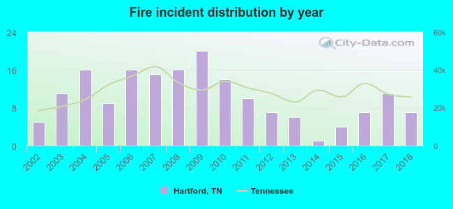 Based on the data from the years 2002 - 2018 the average number of fire incidents per year is 10. The highest number of reported fires - 20 took place in 2009, and the least - 1 in 2014. The data has a growing trend.
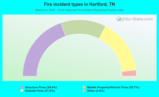 When looking into fire subcategories, the most reports belonged to: Structure Fires (39.4%), and Outside Fires (31.4%).
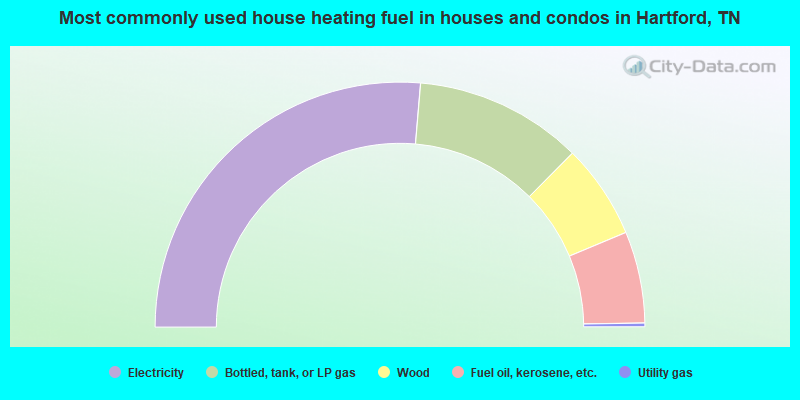
- 52.7%Electricity
- 22.2%Bottled, tank, or LP gas
- 12.5%Wood
- 12.1%Fuel oil, kerosene, etc.
- 0.5%Utility gas
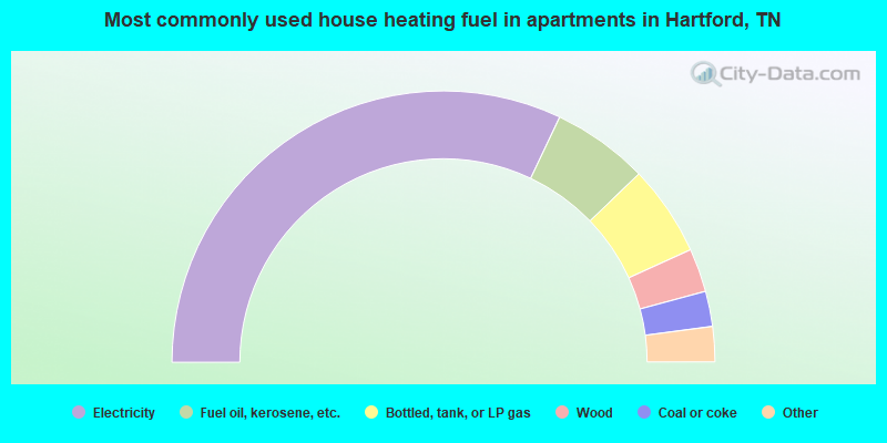
- 64.1%Electricity
- 11.5%Fuel oil, kerosene, etc.
- 10.8%Bottled, tank, or LP gas
- 5.2%Wood
- 4.2%Coal or coke
- 2.4%Utility gas
- 1.7%No fuel used
Hartford compared to Tennessee state average:
- Median house value below state average.
- Black race population percentage significantly below state average.
- Hispanic race population percentage significantly below state average.
- Foreign-born population percentage significantly below state average.
- Renting percentage significantly below state average.
- Length of stay since moving in significantly above state average.
- Number of rooms per house significantly below state average.
- House age significantly below state average.
- Number of college students below state average.
- Percentage of population with a bachelor's degree or higher significantly below state average.

|
Total of 1 patent application in 2008-2024.