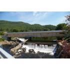
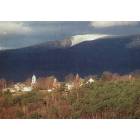
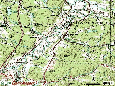
Haverhill, New Hampshire
Submit your own pictures of this town and show them to the world
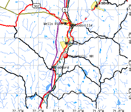
- OSM Map
- General Map
- Google Map
- MSN Map
Population change since 2000: +6.4%
 |
| Males: 2,324 | |
| Females: 2,373 |
| Median resident age: | 45.0 years |
| New Hampshire median age: | 43.9 years |
Zip codes: 03774.
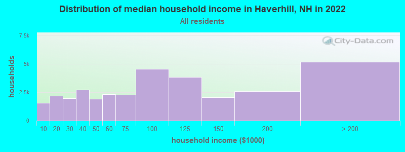
| Haverhill: | $72,056 |
| NH: | $89,992 |
Estimated per capita income in 2022: $39,715 (it was $17,465 in 2000)
Haverhill town income, earnings, and wages data
Estimated median house or condo value in 2022: $258,894 (it was $81,000 in 2000)
| Haverhill: | $258,894 |
| NH: | $384,700 |
Mean prices in 2022: all housing units: $486,096; detached houses: $533,852; townhouses or other attached units: $375,744; in 2-unit structures: $230,260; in 3-to-4-unit structures: $242,363; in 5-or-more-unit structures: $588,257; mobile homes: $127,035
Detailed information about poverty and poor residents in Haverhill, NH


- 4,50295.8%White alone
- 601.3%Hispanic
- 511.1%Two or more races
- 410.9%Asian alone
- 190.4%Black alone
- 170.4%American Indian alone
- 40.09%Other race alone
- 30.06%Native Hawaiian and Other
Pacific Islander alone
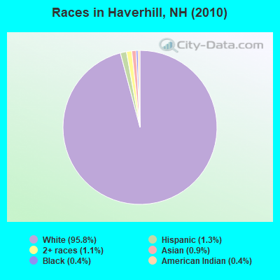
Races in Haverhill detailed stats: ancestries, foreign born residents, place of birth
According to our research of New Hampshire and other state lists, there were 6 registered sex offenders living in Haverhill, New Hampshire as of May 22, 2024.
The ratio of all residents to sex offenders in Haverhill is 783 to 1.
The ratio of registered sex offenders to all residents in this city is lower than the state average.
Type |
2009 |
2010 |
2011 |
2012 |
2013 |
2014 |
2015 |
2016 |
2017 |
2018 |
2019 |
2020 |
2021 |
2022 |
|---|---|---|---|---|---|---|---|---|---|---|---|---|---|---|
| Murders (per 100,000) | 0 (0.0) | 0 (0.0) | 0 (0.0) | 0 (0.0) | 0 (0.0) | 0 (0.0) | 0 (0.0) | 0 (0.0) | 1 (22.0) | 0 (0.0) | 0 (0.0) | 0 (0.0) | 0 (0.0) | 1 (21.6) |
| Rapes (per 100,000) | 3 (63.9) | 3 (63.9) | 0 (0.0) | 0 (0.0) | 6 (129.3) | 4 (86.3) | 4 (86.1) | 2 (43.1) | 2 (44.0) | 4 (87.8) | 5 (109.5) | 4 (87.9) | 1 (22.0) | 2 (43.3) |
| Robberies (per 100,000) | 0 (0.0) | 0 (0.0) | 0 (0.0) | 1 (21.3) | 3 (64.6) | 0 (0.0) | 1 (21.5) | 0 (0.0) | 0 (0.0) | 0 (0.0) | 1 (21.9) | 0 (0.0) | 0 (0.0) | 0 (0.0) |
| Assaults (per 100,000) | 13 (276.9) | 9 (191.6) | 4 (85.1) | 7 (149.1) | 5 (107.7) | 7 (151.0) | 4 (86.1) | 7 (150.8) | 8 (176.1) | 10 (219.4) | 10 (218.9) | 4 (87.9) | 1 (22.0) | 3 (64.9) |
| Burglaries (per 100,000) | 34 (724.3) | 19 (404.5) | 33 (701.7) | 23 (489.8) | 29 (624.9) | 16 (345.1) | 33 (710.1) | 23 (495.6) | 16 (352.3) | 3 (65.8) | 9 (197.0) | 3 (65.9) | 2 (44.0) | 5 (108.2) |
| Thefts (per 100,000) | 102 (2,173) | 89 (1,895) | 62 (1,318) | 73 (1,555) | 82 (1,767) | 73 (1,574) | 136 (2,927) | 111 (2,392) | 49 (1,079) | 84 (1,843) | 62 (1,357) | 61 (1,340) | 35 (770.6) | 55 (1,190) |
| Auto thefts (per 100,000) | 4 (85.2) | 4 (85.2) | 7 (148.8) | 3 (63.9) | 3 (64.6) | 4 (86.3) | 4 (86.1) | 2 (43.1) | 5 (110.1) | 2 (43.9) | 5 (109.5) | 7 (153.8) | 2 (44.0) | 5 (108.2) |
| Arson (per 100,000) | 0 (0.0) | 1 (21.3) | 0 (0.0) | 1 (21.3) | 0 (0.0) | 0 (0.0) | 0 (0.0) | 1 (21.5) | 1 (22.0) | 0 (0.0) | 1 (21.9) | 0 (0.0) | 0 (0.0) | 0 (0.0) |
| City-Data.com crime index | 251.0 | 200.3 | 130.8 | 137.8 | 264.0 | 193.2 | 266.2 | 198.4 | 191.1 | 196.0 | 214.8 | 158.4 | 59.4 | 154.7 |
The City-Data.com crime index weighs serious crimes and violent crimes more heavily. Higher means more crime, U.S. average is 246.1. It adjusts for the number of visitors and daily workers commuting into cities.
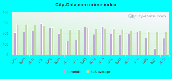
Crime rate in Haverhill detailed stats: murders, rapes, robberies, assaults, burglaries, thefts, arson
Full-time law enforcement employees in 2021, including police officers: 7 (5 officers - 4 male; 1 female).
| Officers per 1,000 residents here: | 1.10 |
| New Hampshire average: | 2.14 |
 Recent articles from our blog. Our writers, many of them Ph.D. graduates or candidates, create easy-to-read articles on a wide variety of topics.

 | Where to go snowshoeing and lodge for a day? (10 replies) |
| Between Hanover and Haverhill (3 replies) |
| Info for the Haverhill and/or Landaff area (2 replies) |
| Nashua tree streets (9 replies) |
| Working in Newburyport, MA, wanting to move back to NH (20 replies) |
| Haverhill NH yay or nay? (3 replies) |
Latest news from Haverhill, NH collected exclusively by city-data.com from local newspapers, TV, and radio stations
Ancestries: English (20.7%), French (14.0%), Irish (13.0%), United States (9.6%), German (7.9%), French Canadian (6.7%).
Current Local Time: EST time zone
Incorporated in 1763
Elevation: 640 feet
Land area: 51.1 square miles.
Population density: 92 people per square mile (very low).
119 residents are foreign born (1.3% Asia, 0.7% Europe, 0.5% North America).
| This town: | 2.7% |
| New Hampshire: | 4.4% |
| Haverhill town: | 2.3% ($1,893) |
| New Hampshire: | 2.3% ($2,946) |
Nearest city with pop. 50,000+: Manchester, NH  (81.4 miles , pop. 107,006).
Nearest city with pop. 200,000+: Boston, MA (130.9 miles , pop. 589,141).
Nearest city with pop. 1,000,000+: Bronx, NY (243.8 miles , pop. 1,332,650).
Nearest cities:
), ), ), )Latitude: 44.09 N, Longitude: 72.01 W

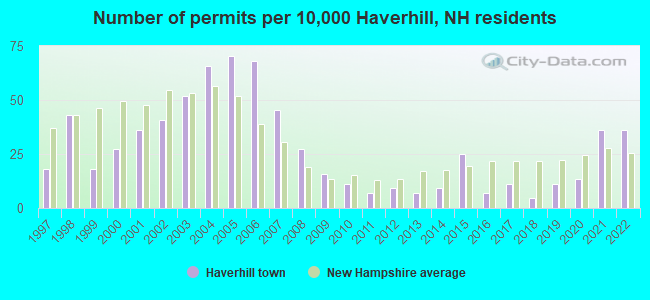
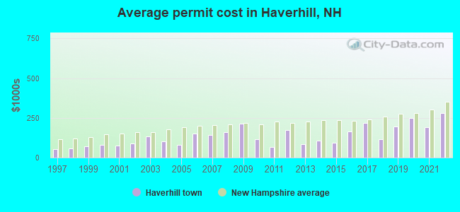
Single-family new house construction building permits:
- 2022: 16 buildings, average cost: $279,200
- 2021: 16 buildings, average cost: $189,500
- 2020: 6 buildings, average cost: $248,200
- 2019: 5 buildings, average cost: $197,200
- 2018: 2 buildings, average cost: $115,000
- 2017: 5 buildings, average cost: $220,000
- 2016: 3 buildings, average cost: $162,900
- 2015: 11 buildings, average cost: $92,300
- 2014: 4 buildings, average cost: $106,300
- 2013: 3 buildings, average cost: $83,300
- 2012: 4 buildings, average cost: $175,000
- 2011: 3 buildings, average cost: $66,700
- 2010: 5 buildings, average cost: $116,000
- 2009: 7 buildings, average cost: $214,300
- 2008: 12 buildings, average cost: $158,200
- 2007: 20 buildings, average cost: $143,800
- 2006: 30 buildings, average cost: $151,500
- 2005: 31 buildings, average cost: $81,000
- 2004: 29 buildings, average cost: $100,700
- 2003: 23 buildings, average cost: $132,800
- 2002: 18 buildings, average cost: $88,000
- 2001: 16 buildings, average cost: $76,200
- 2000: 12 buildings, average cost: $81,600
- 1999: 8 buildings, average cost: $70,000
- 1998: 19 buildings, average cost: $60,300
- 1997: 8 buildings, average cost: $54,100
| Here: | 2.6% |
| New Hampshire: | 2.5% |
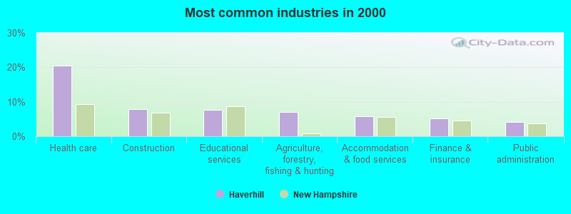
- Health care (20.6%)
- Construction (7.8%)
- Educational services (7.6%)
- Agriculture, forestry, fishing & hunting (6.9%)
- Accommodation & food services (5.8%)
- Finance & insurance (5.1%)
- Public administration (4.2%)
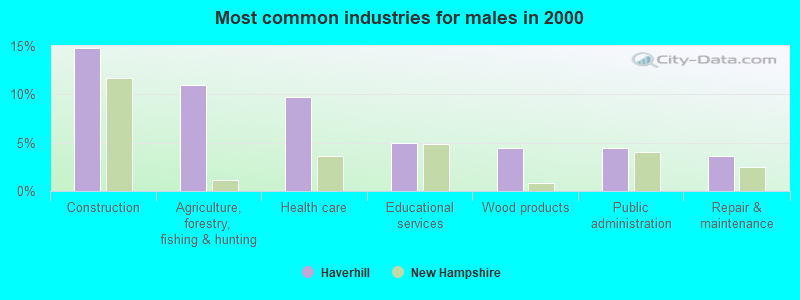
- Construction (14.7%)
- Agriculture, forestry, fishing & hunting (11.0%)
- Health care (9.7%)
- Educational services (4.9%)
- Wood products (4.4%)
- Public administration (4.4%)
- Repair & maintenance (3.6%)
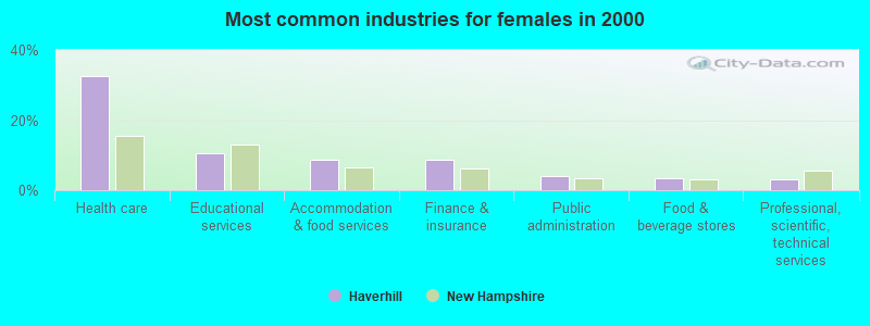
- Health care (32.7%)
- Educational services (10.6%)
- Accommodation & food services (8.7%)
- Finance & insurance (8.6%)
- Public administration (4.0%)
- Food & beverage stores (3.5%)
- Professional, scientific, technical services (3.2%)
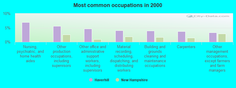
- Nursing, psychiatric, and home health aides (6.9%)
- Other production occupations, including supervisors (5.5%)
- Other office and administrative support workers, including supervisors (4.6%)
- Material recording, scheduling, dispatching, and distributing workers (4.0%)
- Building and grounds cleaning and maintenance occupations (3.9%)
- Carpenters (3.7%)
- Other management occupations, except farmers and farm managers (3.3%)
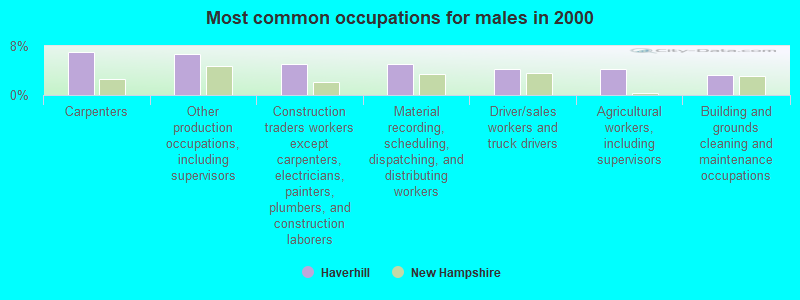
- Carpenters (7.1%)
- Other production occupations, including supervisors (6.6%)
- Construction traders workers except carpenters, electricians, painters, plumbers, and construction laborers (5.1%)
- Material recording, scheduling, dispatching, and distributing workers (5.0%)
- Driver/sales workers and truck drivers (4.3%)
- Agricultural workers, including supervisors (4.3%)
- Building and grounds cleaning and maintenance occupations (3.2%)
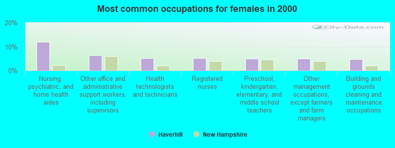
- Nursing, psychiatric, and home health aides (11.9%)
- Other office and administrative support workers, including supervisors (6.3%)
- Health technologists and technicians (5.1%)
- Registered nurses (5.1%)
- Preschool, kindergarten, elementary, and middle school teachers (5.0%)
- Other management occupations, except farmers and farm managers (4.9%)
- Building and grounds cleaning and maintenance occupations (4.7%)
Average climate in Haverhill, New Hampshire
Based on data reported by over 4,000 weather stations


(lower is better)
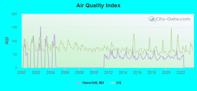
Air Quality Index (AQI) level in 2021 was 39.8. This is significantly better than average.
| City: | 39.8 |
| U.S.: | 72.6 |
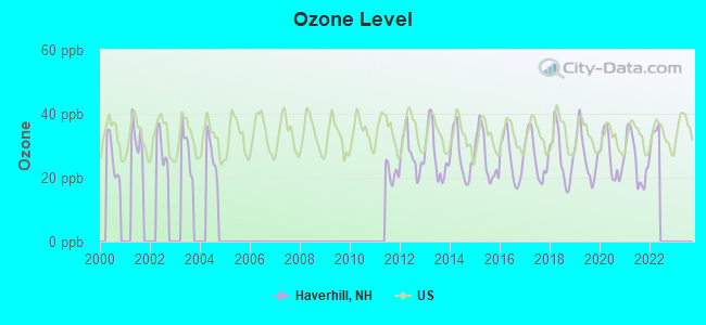
Ozone [ppb] level in 2021 was 25.7. This is better than average. Closest monitor was 0.6 miles away from the city center.
| City: | 25.7 |
| U.S.: | 33.3 |
Tornado activity:
Haverhill-area historical tornado activity is significantly below New Hampshire state average. It is 80% smaller than the overall U.S. average.
On 8/11/1966, a category F2 (max. wind speeds 113-157 mph) tornado 4.1 miles away from the Haverhill town center caused between $50,000 and $500,000 in damages.
On 5/11/1973, a category F2 tornado 36.2 miles away from the town center .
Earthquake activity:
Haverhill-area historical earthquake activity is significantly above New Hampshire state average. It is 72% smaller than the overall U.S. average.On 4/20/2002 at 10:50:47, a magnitude 5.3 (5.3 ML, Depth: 3.0 mi, Class: Moderate, Intensity: VI - VII) earthquake occurred 88.6 miles away from the city center
On 4/20/2002 at 10:50:47, a magnitude 5.2 (5.2 MB, 4.2 MS, 5.2 MW, 5.0 MW) earthquake occurred 89.0 miles away from the city center
On 10/7/1983 at 10:18:46, a magnitude 5.3 (5.1 MB, 5.3 LG, 5.1 ML) earthquake occurred 116.5 miles away from the city center
On 1/19/1982 at 00:14:42, a magnitude 4.7 (4.5 MB, 4.7 MD, 4.5 LG, Class: Light, Intensity: IV - V) earthquake occurred 45.7 miles away from the city center
On 10/16/2012 at 23:12:25, a magnitude 4.7 (4.7 ML, Depth: 10.0 mi) earthquake occurred 75.6 miles away from Haverhill center
On 6/16/1995 at 12:13:11, a magnitude 3.8 (3.8 LG, Depth: 3.1 mi, Class: Light, Intensity: II - III) earthquake occurred 14.2 miles away from Haverhill center
Magnitude types: regional Lg-wave magnitude (LG), body-wave magnitude (MB), duration magnitude (MD), local magnitude (ML), surface-wave magnitude (MS), moment magnitude (MW)
Natural disasters:
The number of natural disasters in Grafton County (32) is a lot greater than the US average (15).Major Disasters (Presidential) Declared: 20
Emergencies Declared: 9
Causes of natural disasters: Floods: 16, Storms: 16, Hurricanes: 3, Snows: 3, Winter Storms: 3, Tropical Storms: 2, Blizzard: 1, Heavy Rain: 1, Ice Storm: 1, Landslide: 1, Snowfall: 1, Snowstorm: 1, Wind: 1, Other: 1 (Note: some incidents may be assigned to more than one category).
Hospitals and medical centers near Haverhill:
- GRAFTON COUNTY NURSING HOME (Nursing Home, about 1 miles away; NORTH HAVERHILL, NH)
- COTTAGE HOSPITAL Critical Access Hospitals (about 4 miles away; WOODSVILLE, NH)
- GLENCLIFF HOME FOR THE ELDERLY (Nursing Home, about 10 miles away; GLENCLIFF, NH)
- LAFAYETTE CENTER, GENESIS HEALTHCARE (Nursing Home, about 16 miles away; FRANCONIA, NH)
Airports and heliports located in Haverhill:
- Dean Memorial Airport (5B9) (Runways: 1, Itinerant Ops: 750, Local Ops: 4,000)
- Brookside Heliport (2NH9)
Colleges/universities with over 2000 students nearest to Haverhill:
- Plymouth State University (about 29 miles; Plymouth, NH; Full-time enrollment: 4,838)
- Dartmouth College (about 31 miles; Hanover, NH; FT enrollment: 6,030)
- Norwich University (about 33 miles; Northfield, VT; FT enrollment: 4,221)
- Middlebury College (about 59 miles; Middlebury, VT; FT enrollment: 3,077)
- Saint Michael's College (about 64 miles; Colchester, VT; FT enrollment: 2,336)
- Community College of Vermont (about 65 miles; Winooski, VT; FT enrollment: 3,394)
- NHTI-Concord's Community College (about 65 miles; Concord, NH; FT enrollment: 2,865)
Public elementary/middle school in Haverhill:
- HAVERHILL COOPERATIVE MIDDLE SCHOOL (Students: 310, Location: 175 MORRILL DR., Grades: 4-8)
Points of interest:
Notable locations in Haverhill: Blackmount Station (A), Haverhill Corner Historic District (B), Woodsville Emergency Services (C), Woodsville Opera Building (D), Woodsville Free Public Library (E), North Haverhill Fire Department (F), Woodsville Fire and Rescue (G), Haverhill Corner Fire Department (H), Grafton County Offices (I). Display/hide their locations on the map
Shopping Center: Ames Plaza Shopping Center (1). Display/hide its location on the map
Churches in Haverhill include: Church at the Crossroads Advent Christian Church (A), East Haverhill United Methodist Church (B), First Congregational Church (C), North Haverhill United Methodist Church (D), Saint Luke Episcopal Church (E), Trinity Church of the Nazarene (F). Display/hide their locations on the map
Cemeteries: Ladd Street Cemetery (1), Abbot Cemetery (2), Center Haverhill Cemetery (3), East Haverhill Cemetery (4), Pine Grove Cemetery (5), Horse Meadow Cemetery (6), North Haverhill Cemetery (7). Display/hide their locations on the map
Lakes and reservoirs: Wood Pond (A), Clark Pond (B), French Pond (C), Lower Mountain Lake (D), Upper Mountain Lake (E), Oliverian Brook (F), Ammonoosuc River Reservoir (G). Display/hide their locations on the map
Streams, rivers, and creeks: Wilmont Brook (A), Clark Brook (B), Oliverian Brook (C), Morris Brook (D), Titus Brook (E). Display/hide their locations on the map
Tourist attraction: Alumni Hall Cultural & Interpretive Center (Cultural Attractions- Events- & Facilities; 75 Court Street) (1). Display/hide its approximate location on the map
Birthplace of: John Page (New Hampshire) - Politician.
Drinking water stations with addresses in Haverhill and their reported violations in the past:
OLIVERIAN SCH (Population served: 76, Groundwater):Past monitoring violations:WINDY RIDGE ORCHARD (Population served: 50, Groundwater):
- 2 routine major monitoring violations
Past health violations:BECKET HOUSE AT CAMPTON (Population served: 25, Groundwater):Past monitoring violations:
- MCL, Monthly (TCR) - Between OCT-2013 and DEC-2013, Contaminant: Coliform. Follow-up actions: St Public Notif requested (OCT-29-2013), St Violation/Reminder Notice (OCT-29-2013), St Public Notif received (NOV-12-2013)
- MCL, Monthly (TCR) - Between JUL-2013 and SEP-2013, Contaminant: Coliform. Follow-up actions: St Public Notif requested (OCT-14-2013), St Violation/Reminder Notice (OCT-14-2013), St Public Notif received (OCT-30-2013)
- Monitoring, Source Water (GWR) - Between OCT-24-2012 and NOV-24-2012, Contaminant: E. COLI. Follow-up actions: St Public Notif requested (DEC-03-2012), St Violation/Reminder Notice (DEC-03-2012), St Public Notif received (FEB-15-2013), St Compliance achieved (MAY-21-2013)
- Monitoring, Repeat Major (TCR) - Between OCT-2012 and DEC-2012, Contaminant: Coliform (TCR). Follow-up actions: St Public Notif requested (DEC-03-2012), St Violation/Reminder Notice (DEC-03-2012), St Public Notif received (FEB-15-2013), St Compliance achieved (MAY-21-2013)
- One minor monitoring violation
Past health violations:Past monitoring violations:
- MCL, Monthly (TCR) - In AUG-2013, Contaminant: Coliform. Follow-up actions: St Public Notif requested (AUG-15-2013), St Violation/Reminder Notice (AUG-15-2013), St Public Notif received (SEP-04-2013), St Compliance achieved (APR-10-2014)
- MCL, Monthly (TCR) - In OCT-2012, Contaminant: Coliform. Follow-up actions: St Public Notif requested (OCT-11-2012), St Violation/Reminder Notice (OCT-11-2012), St Public Notif received (NOV-01-2012), St Formal NOV issued (NOV-20-2012), St Compliance achieved (APR-16-2013)
- MCL, Monthly (TCR) - In SEP-2012, Contaminant: Coliform. Follow-up actions: St Public Notif requested (SEP-24-2012), St Violation/Reminder Notice (SEP-24-2012), St Public Notif received (OCT-09-2012), St Formal NOV issued (NOV-20-2012), St Compliance achieved (APR-16-2013)
- MCL, Monthly (TCR) - In OCT-2011, Contaminant: Coliform. Follow-up actions: St Public Notif requested (OCT-17-2011), St Violation/Reminder Notice (OCT-17-2011), St Public Notif received (OCT-27-2011), St Compliance achieved (MAY-07-2012)
- MCL, Monthly (TCR) - In JUN-2010, Contaminant: Coliform. Follow-up actions: St Public Notif requested (JUN-14-2010), St Violation/Reminder Notice (JUN-14-2010), St Public Notif received (JUN-24-2010), St Compliance achieved (JAN-03-2011)
- OCCT/SOWT Study/Recommendation - In NOV-01-2009, Contaminant: Lead and Copper Rule. Follow-up actions: St Public Notif requested (OCT-29-2009), St Formal NOV issued (OCT-29-2009), St BCA signed (NOV-12-2009), St Public Notif received (NOV-18-2009), St Compliance achieved (APR-02-2010), St Intentional no-action (APR-02-2010)
- 4 other older health violations
- Initial, Follow-up, or Routine Source Water M/R - In JUL-01-2009, Contaminant: Lead and Copper Rule. Follow-up actions: St Public Notif requested (OCT-29-2009), St Formal NOV issued (OCT-29-2009), St BCA signed (NOV-12-2009), St Public Notif received (NOV-18-2009), St Compliance achieved (JAN-06-2010)
- Monitoring, Repeat Major (TCR) - Between JUL-2008 and SEP-2008, Contaminant: Coliform (TCR). Follow-up actions: St Public Notif requested (SEP-26-2008), St Violation/Reminder Notice (SEP-26-2008), St Public Notif received (OCT-02-2008), St Compliance achieved (JAN-05-2009)
- One regular monitoring violation
| This town: | 2.3 people |
| New Hampshire: | 2.5 people |
| This town: | 62.7% |
| Whole state: | 66.3% |
| This town: | 9.9% |
| Whole state: | 8.3% |
Likely homosexual households (counted as self-reported same-sex unmarried-partner households)
- Lesbian couples: 0.4% of all households
- Gay men: 0.2% of all households
| This town: | 6.8% |
| Whole state: | 6.5% |
| This town: | 3.0% |
| Whole state: | 2.8% |
People in group quarters in Haverhill in 2010:
- 130 people in nursing facilities/skilled-nursing facilities
- 118 people in local jails and other municipal confinement facilities
- 20 people in workers' group living quarters and job corps centers
- 8 people in college/university student housing
People in group quarters in Haverhill in 2000:
- 102 people in nursing homes
- 71 people in local jails and other confinement facilities (including police lockups)
- 51 people in homes or halfway houses for drug/alcohol abuse
- 14 people in other noninstitutional group quarters
For population 15 years and over in Haverhill:
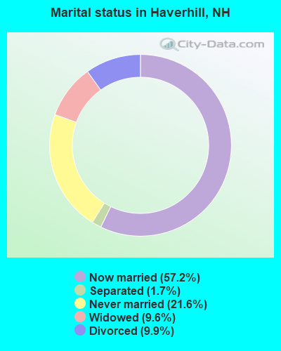
- Never married: 21.6%
- Now married: 57.2%
- Separated: 1.7%
- Widowed: 9.6%
- Divorced: 9.9%
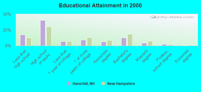
For population 25 years and over in Haverhill:
- High school or higher: 82.4%
- Bachelor's degree or higher: 19.4%
- Graduate or professional degree: 7.0%
- Unemployed: 5.3%
- Mean travel time to work (commute): 26.0 minutes
| Here: | 10.8 |
| New Hampshire average: | 10.9 |


Graphs represent county-level data. Detailed 2008 Election Results
Religion statistics for Haverhill, NH (based on Grafton County data)


| Religion | Adherents | Congregations |
|---|---|---|
| Catholic | 9,503 | 12 |
| Mainline Protestant | 7,832 | 57 |
| Evangelical Protestant | 1,494 | 29 |
| Other | 1,320 | 11 |
| None | 68,969 | - |
Food Environment Statistics:
| Grafton County: | 3.87 / 10,000 pop. |
| New Hampshire: | 2.14 / 10,000 pop. |
| Grafton County: | 0.23 / 10,000 pop. |
| New Hampshire: | 0.15 / 10,000 pop. |
| Grafton County: | 1.29 / 10,000 pop. |
| State: | 1.78 / 10,000 pop. |
| Grafton County: | 6.45 / 10,000 pop. |
| New Hampshire: | 4.02 / 10,000 pop. |
| Grafton County: | 14.41 / 10,000 pop. |
| New Hampshire: | 9.70 / 10,000 pop. |
| Here: | 7.2% |
| New Hampshire: | 7.6% |
| Grafton County: | 22.9% |
| State: | 24.4% |
| This county: | 15.9% |
| New Hampshire: | 15.9% |
Strongest AM radio stations in Haverhill:
- WTWN (1100 AM; daytime; 5 kW; WELLS RIVER, VT; Owner: PUFFER BROADCASTING, INC.)
- WPNH (1300 AM; 5 kW; PLYMOUTH, NH; Owner: NORTHEAST COMMUNICATIONS CORPORATION)
- WCHP (760 AM; 35 kW; CHAMPLAIN, NY; Owner: CHAMPLAIN RADIO, INC.)
- WRKO (680 AM; 50 kW; BOSTON, MA; Owner: ENTERCOM BOSTON LICENSE, LLC)
- WDEV (550 AM; 5 kW; WATERBURY, VT; Owner: RADIO VERMONT, INC.)
- WNNZ (640 AM; 50 kW; WESTFIELD, MA; Owner: CLEAR CHANNEL BROADCASTING LICENSES, INC.)
- WNTK (1020 AM; 10 kW; NEWPORT, NH; Owner: KOOR COMMUNICATIONS, INC.)
- WCRN (830 AM; 50 kW; WORCESTER, MA; Owner: CARTER BROADCASTING CORPORATION)
- WEEI (850 AM; 50 kW; BOSTON, MA; Owner: ENTERCOM BOSTON LICENSE, LLC)
- WGY (810 AM; 50 kW; SCHENECTADY, NY; Owner: CLEAR CHANNEL BROADCASTING LICENSES, INC.)
- WKOX (1200 AM; 50 kW; FRAMINGHAM, MA; Owner: CAPSTAR TX LIMITED PARTNERSHIP)
- WBZ (1030 AM; 50 kW; BOSTON, MA; Owner: INFINITY BROADCASTING OPERATIONS, INC.)
- WICY (1490 AM; 50 kW; MALONE, NY; Owner: CARTIER COMMUNICATIONS INC.)
Strongest FM radio stations in Haverhill:
- WYKR-FM (101.3 FM; HAVERHILL, NH; Owner: PUFFER BROADCASTING, INC.)
- WPKQ (103.7 FM; NORTH CONWAY, NH; Owner: CITADEL BROADCASTING COMPANY)
- WHOM (94.9 FM; MT. WASHINGTON, NH; Owner: CITADEL BROADCASTING COMPANY)
- WVFM (105.7 FM; CAMPTON, NH; Owner: DEVON BROADCASTING COMPANY, INC.)
- WLTN-FM (96.7 FM; LISBON, NH; Owner: PROFILE BROADCASTING CO., INC.)
- WGMT (97.7 FM; LYNDON, VT; Owner: VERMONT BROADCAST ASSOCIATES, INC.)
- WMTK (106.3 FM; LITTLETON, NH; Owner: VERMONT BROADCAST ASSOCIATES, INC.)
- WDOT (95.7 FM; DANVILLE, VT; Owner: MONTPELIER BROADCASTING INC)
- WPNH-FM (100.1 FM; PLYMOUTH, NH; Owner: NORTHEAST COMMUNICATIONS CORPORATION)
- WCVT (101.7 FM; STOWE, VT; Owner: RADIO VERMONT CLASSICS, L.L.C.)
- WEVH (91.3 FM; HANOVER, NH; Owner: NEW HAMPSHIRE PUBLIC RADIO INC)
- WSCY (106.9 FM; MOULTONBOROUGH, NH; Owner: NORTHEAST COMMUNICATIONS CORPORATION)
- WLKC (103.3 FM; WATERBURY, VT; Owner: RADIO BROADCASTING SERVICES, INC.)
- WVPS (107.9 FM; BURLINGTON, VT; Owner: VERMONT PUBLIC RADIO)
- WEZF (92.9 FM; BURLINGTON, VT; Owner: CAPSTAR TX LIMITED PARTNERSHIP)
- WDEV-FM (96.1 FM; WARREN, VT; Owner: RADIO VERMONT, INC.)
- WEBK (105.3 FM; KILLINGTON, VT; Owner: 6 JOHNSON ROAD LICENSES, INC.)
- WJJR (98.1 FM; RUTLAND, VT; Owner: 6 JOHNSON ROAD LICENSES, INC.)
- WZRT (97.1 FM; RUTLAND, VT; Owner: CAPSTAR TX LIMITED PARTNERSHIP)
- WNCS (104.7 FM; MONTPELIER, VT; Owner: MONTPELIER BROADCASTING, INC.)
TV broadcast stations around Haverhill:
- WLED-TV (Channel 49; LITTLETON, NH; Owner: UNIVERSITY OF NEW HAMPSHIRE)
- W15BK (Channel 15; HANOVER, NH; Owner: UNIVERSITY OF NEW HAMPSHIRE)
- National Bridge Inventory (NBI) Statistics
- 15Number of bridges
- 144ft / 43.9mTotal length
- $47,130,000Total costs
- 24,533Total average daily traffic
- 1,980Total average daily truck traffic
- 36,299Total future (year 2042) average daily traffic
- New bridges - historical statistics
- 21920-1929
- 11930-1939
- 11940-1949
- 11960-1969
- 41970-1979
- 11980-1989
- 21990-1999
- 22010-2019
- 12020-2022
FCC Registered Antenna Towers:
1- Anthony Handley, Off Castle Road (Lat: 44.063556 Lon: -72.045806), Type: 50.6, Structure height: 33009 m, Overall height: 48.8 m, Registrant: Blue Sky Towers Iii, LLC, Chuck.Laurette@blueskytower.Com, Suite 106, North- Reading, Phone: (888) 960-7958
FCC Registered Broadcast Land Mobile Towers:
3- HAVERHILL, Nh Route 10 (Lat: 44.108000 Lon: -72.038667), Type: Tower, Structure height: 30.4 m, Overall height: 31.6 m, Call Sign: KOB536, Licensee ID: L00307774,
Assigned Frequencies: 453.775 MHz, Grant Date: 08/25/2022, Expiration Date: 11/06/2032, Registrant: State Of New Hampshire, Department Of Transportation, Division Of Operations, Seven Hazen Drive, Concord, NH 03301-0483, Phone: (603) 271-6862, Fax: (603) 271-8626, Email:
- Grafton County Courthouse Rt 10 (Lat: 44.113389 Lon: -72.041750), Call Sign: KQL793,
Assigned Frequencies: 155.475 MHz, 156.090 MHz, Grant Date: 04/27/2022, Expiration Date: 07/09/2032, Registrant: Nh Dept. Of Safety/Emergency Services And Communications, 33 Hazen Dr (Mailing), Concord, NH 03305, Phone: (603) 528-7541, Fax: (603) 271-6629, Email:
- Lat: 44.086222 Lon: -71.990778, Call Sign: WQDK238,
Assigned Frequencies: 72.1000 MHz, Grant Date: 09/15/2005, Expiration Date: 09/15/2015, Cancellation Date: 11/21/2015, Certifier: Pat Ausden, Registrant: Primex Wireless, Inc., 965 Wells Street, Lake Geneva, WI 53147, Phone: (262) 249-2344, Email:
FCC Registered Amateur Radio Licenses:
1- Call Sign: K1THJ, Licensee ID: L00328691, Grant Date: 02/27/2001, Expiration Date: 03/05/2011, Cancellation Date: 03/06/2013, Registrant: William F Koch Jr, 293 Dartmouth College Hwy, Haverhill, NH 03765
FAA Registered Aircraft:
1- Aircraft: CESSNA 152 (Category: Land, Seats: 2, Weight: Up to 12,499 Pounds), Engine: LYCOMING 0-235 SERIES (115 HP) (4 Cycle)
N-Number: 94652, N94652, N-94652, Serial Number: 15285752, Year manufactured: 1983, Airworthiness Date: 04/26/1983, Certificate Issue Date: 02/05/2018
Registrant (Individual): Clifford E Batchelder, 291 Cemetery Rd, Haverhill, NH 03765
- 65.8%Fuel oil, kerosene, etc.
- 24.9%Bottled, tank, or LP gas
- 8.2%Wood
- 1.0%Electricity
- 63.3%Fuel oil, kerosene, etc.
- 24.8%Bottled, tank, or LP gas
- 4.8%Electricity
- 3.6%Wood
- 2.0%Utility gas
- 1.4%No fuel used
Haverhill compared to New Hampshire state average:
- Unemployed percentage below state average.
- Black race population percentage significantly below state average.
- Hispanic race population percentage significantly below state average.
- Foreign-born population percentage below state average.
- Length of stay since moving in significantly above state average.
- Number of rooms per house significantly below state average.
- House age significantly below state average.
- Institutionalized population percentage significantly above state average.
- Number of college students below state average.
- Percentage of population with a bachelor's degree or higher below state average.
Haverhill on our top lists:
- #49 on the list of "Top 101 cities with the largest percentage of people in homes or halfway houses for drug/alcohol abuse (population 1,000+)"
- #22 on the list of "Top 101 counties with highest percentage of residents voting for 3rd party candidates in the 2012 Presidential Election"
- #35 on the list of "Top 101 counties with the best general health status score of residents (1-5), 3 years of data"
- #50 on the list of "Top 101 counties with the highest percentage of residents that keep firearms around their homes"
- #67 on the list of "Top 101 counties with the highest percentage of residents that exercised in the past month"
- #67 on the list of "Top 101 counties with the lowest Particulate Matter (PM2.5) Annual air pollution readings in 2012 (µg/m3)"