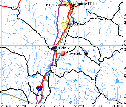
Piermont, New Hampshire
Submit your own pictures of this town and show them to the world
- OSM Map
- General Map
- Google Map
- MSN Map
Population change since 2000: +11.4%
 |
| Males: 390 | |
| Females: 400 |
| Median resident age: | 46.8 years |
| New Hampshire median age: | 43.9 years |
Zip codes: 03779.
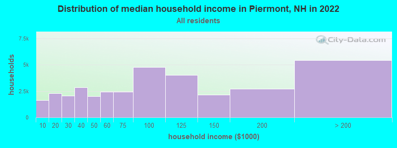
| Piermont: | $75,493 |
| NH: | $89,992 |
Estimated per capita income in 2022: $50,444 (it was $22,183 in 2000)
Piermont town income, earnings, and wages data
Estimated median house or condo value in 2022: $317,066 (it was $99,200 in 2000)
| Piermont: | $317,066 |
| NH: | $384,700 |
Mean prices in 2022: all housing units: $486,096; detached houses: $533,852; townhouses or other attached units: $375,744; in 2-unit structures: $230,260; in 3-to-4-unit structures: $242,363; in 5-or-more-unit structures: $588,257; mobile homes: $127,035
Detailed information about poverty and poor residents in Piermont, NH


- 76296.5%White alone
- 111.4%Two or more races
- 70.9%Asian alone
- 60.8%Hispanic
- 30.4%American Indian alone
- 10.1%Black alone
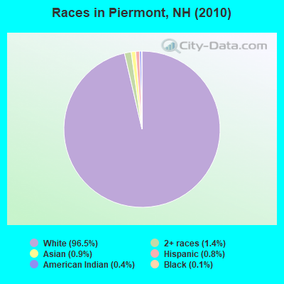
Races in Piermont detailed stats: ancestries, foreign born residents, place of birth
According to our research of New Hampshire and other state lists, there was 1 registered sex offender living in Piermont, New Hampshire as of May 17, 2024.
The ratio of all residents to sex offenders in Piermont is 790 to 1.
The ratio of registered sex offenders to all residents in this city is lower than the state average.
Type |
2020 |
2021 |
2022 |
|---|---|---|---|
| Murders (per 100,000) | 0 (0.0) | 0 (0.0) | 0 (0.0) |
| Rapes (per 100,000) | 2 (246.9) | 0 (0.0) | 0 (0.0) |
| Robberies (per 100,000) | 0 (0.0) | 0 (0.0) | 0 (0.0) |
| Assaults (per 100,000) | 1 (123.5) | 0 (0.0) | 1 (128.5) |
| Burglaries (per 100,000) | 3 (370.4) | 1 (121.8) | 0 (0.0) |
| Thefts (per 100,000) | 8 (987.7) | 6 (730.8) | 5 (642.7) |
| Auto thefts (per 100,000) | 2 (246.9) | 2 (243.6) | 0 (0.0) |
| Arson (per 100,000) | 0 (0.0) | 0 (0.0) | 0 (0.0) |
| City-Data.com crime index | 307.4 | 57.2 | 51.4 |
The City-Data.com crime index weighs serious crimes and violent crimes more heavily. Higher means more crime, U.S. average is 246.1. It adjusts for the number of visitors and daily workers commuting into cities.
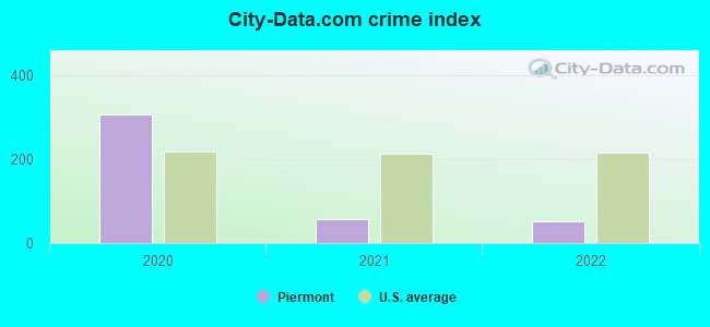
Crime rate in Piermont detailed stats: murders, rapes, robberies, assaults, burglaries, thefts, arson
Full-time law enforcement employees in 2021, including police officers: 1 (1 officers - 1 male; 0 female).
| Officers per 1,000 residents here: | 1.22 |
| New Hampshire average: | 2.14 |
 Recent articles from our blog. Our writers, many of them Ph.D. graduates or candidates, create easy-to-read articles on a wide variety of topics.

 | Considering moving to Lebanon, NH from TN for Dartmouth...advice? (19 replies) |
| State of public schools in New Hampshire (30 replies) |
| Picture Thread for NH (1997 replies) |
Latest news from Piermont, NH collected exclusively by city-data.com from local newspapers, TV, and radio stations
Ancestries: English (30.3%), Irish (21.3%), French (9.4%), Scottish (8.2%), French Canadian (6.1%), German (5.5%).
Current Local Time: EST time zone
Incorporated in 1764
Elevation: 568 feet
Land area: 38.5 square miles.
Population density: 21 people per square mile (very low).
14 residents are foreign born
| This town: | 2.0% |
| New Hampshire: | 4.4% |
| Piermont town: | 2.1% ($2,123) |
| New Hampshire: | 2.3% ($2,946) |
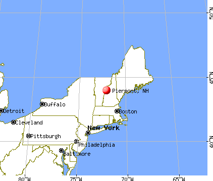
Nearest city with pop. 50,000+: Manchester, NH  (74.7 miles , pop. 107,006).
Nearest city with pop. 200,000+: Boston, MA (124.2 miles , pop. 589,141).
Nearest city with pop. 1,000,000+: Bronx, NY (235.7 miles , pop. 1,332,650).
Nearest cities:
), ), )Latitude: 43.98 N, Longitude: 72.04 W
Area code: 603

Single-family new house construction building permits:
- 1999: 5 buildings, average cost: $78,200
- 1998: 4 buildings, average cost: $78,200
- 1997: 3 buildings, average cost: $78,200
| Here: | 3.2% |
| New Hampshire: | 2.5% |
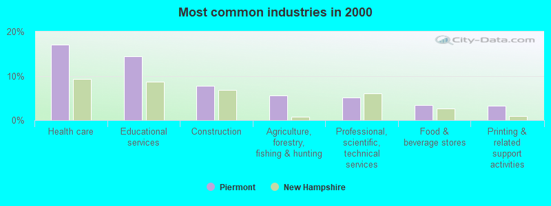
- Health care (17.1%)
- Educational services (14.4%)
- Construction (7.7%)
- Agriculture, forestry, fishing & hunting (5.6%)
- Professional, scientific, technical services (5.1%)
- Food & beverage stores (3.5%)
- Printing & related support activities (3.2%)
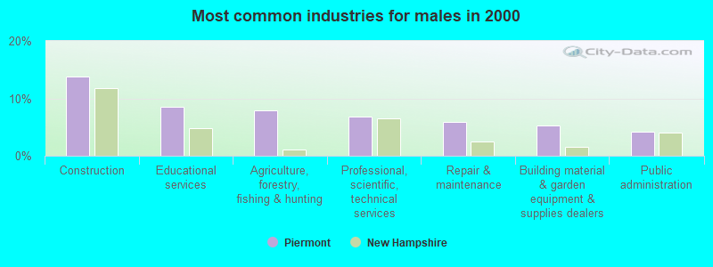
- Construction (13.8%)
- Educational services (8.5%)
- Agriculture, forestry, fishing & hunting (7.9%)
- Professional, scientific, technical services (6.9%)
- Repair & maintenance (5.8%)
- Building material & garden equipment & supplies dealers (5.3%)
- Public administration (4.2%)
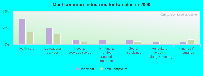
- Health care (31.2%)
- Educational services (20.4%)
- Food & beverage stores (5.9%)
- Printing & related support activities (5.4%)
- Social assistance (5.4%)
- Agriculture, forestry, fishing & hunting (3.2%)
- Finance & insurance (3.2%)
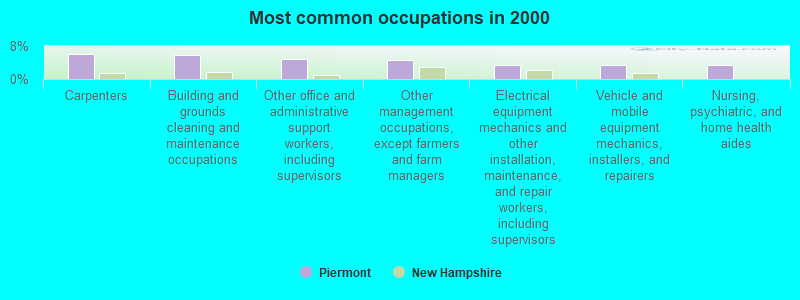
- Carpenters (6.1%)
- Building and grounds cleaning and maintenance occupations (5.9%)
- Other office and administrative support workers, including supervisors (4.8%)
- Other management occupations, except farmers and farm managers (4.5%)
- Electrical equipment mechanics and other installation, maintenance, and repair workers, including supervisors (3.5%)
- Vehicle and mobile equipment mechanics, installers, and repairers (3.5%)
- Nursing, psychiatric, and home health aides (3.5%)
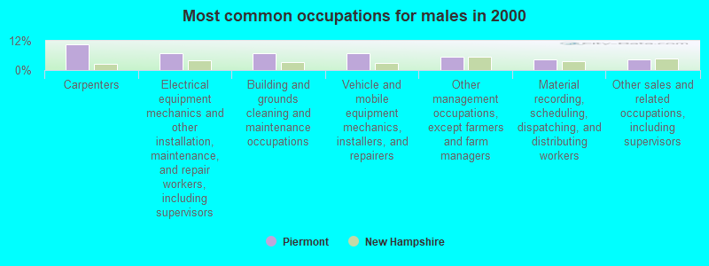
- Carpenters (10.6%)
- Electrical equipment mechanics and other installation, maintenance, and repair workers, including supervisors (6.9%)
- Building and grounds cleaning and maintenance occupations (6.9%)
- Vehicle and mobile equipment mechanics, installers, and repairers (6.9%)
- Other management occupations, except farmers and farm managers (5.3%)
- Material recording, scheduling, dispatching, and distributing workers (4.2%)
- Other sales and related occupations, including supervisors (4.2%)
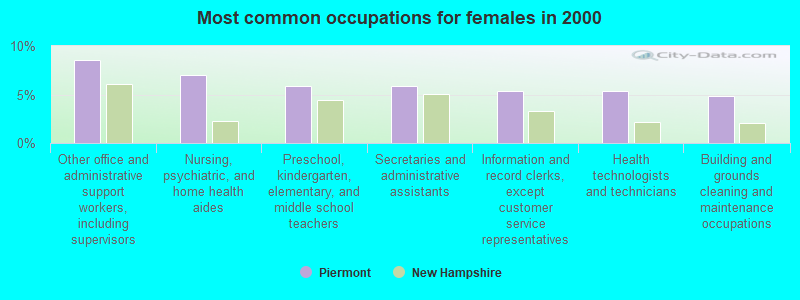
- Other office and administrative support workers, including supervisors (8.6%)
- Nursing, psychiatric, and home health aides (7.0%)
- Preschool, kindergarten, elementary, and middle school teachers (5.9%)
- Secretaries and administrative assistants (5.9%)
- Information and record clerks, except customer service representatives (5.4%)
- Health technologists and technicians (5.4%)
- Building and grounds cleaning and maintenance occupations (4.8%)
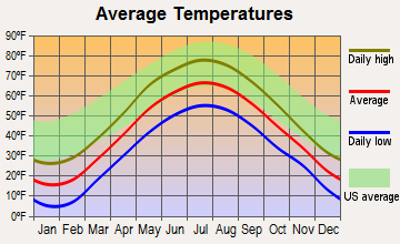
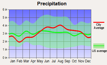
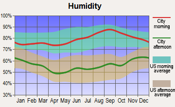
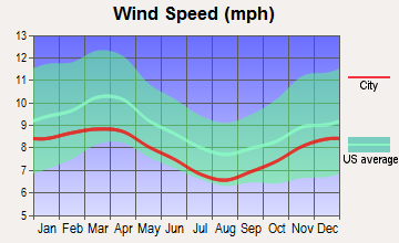
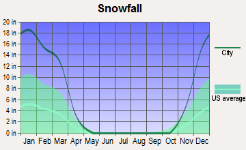
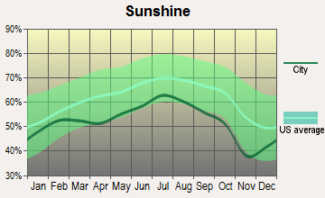
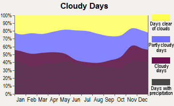
Average climate in Piermont, New Hampshire
Based on data reported by over 4,000 weather stations
(lower is better)
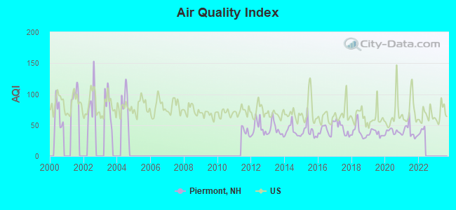
Air Quality Index (AQI) level in 2021 was 39.8. This is significantly better than average.
| City: | 39.8 |
| U.S.: | 72.6 |
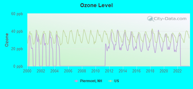
Ozone [ppb] level in 2021 was 25.7. This is better than average. Closest monitor was 7.6 miles away from the city center.
| City: | 25.7 |
| U.S.: | 33.3 |
Tornado activity:
Piermont-area historical tornado activity is below New Hampshire state average. It is 77% smaller than the overall U.S. average.
On 8/11/1966, a category F2 (max. wind speeds 113-157 mph) tornado 3.2 miles away from the Piermont town center caused between $50,000 and $500,000 in damages.
On 5/11/1973, a category F2 tornado 28.5 miles away from the town center .
Earthquake activity:
Piermont-area historical earthquake activity is significantly above New Hampshire state average. It is 71% smaller than the overall U.S. average.On 4/20/2002 at 10:50:47, a magnitude 5.3 (5.3 ML, Depth: 3.0 mi, Class: Moderate, Intensity: VI - VII) earthquake occurred 89.9 miles away from Piermont center
On 4/20/2002 at 10:50:47, a magnitude 5.2 (5.2 MB, 4.2 MS, 5.2 MW, 5.0 MW) earthquake occurred 90.2 miles away from the city center
On 10/7/1983 at 10:18:46, a magnitude 5.3 (5.1 MB, 5.3 LG, 5.1 ML) earthquake occurred 114.4 miles away from the city center
On 1/19/1982 at 00:14:42, a magnitude 4.7 (4.5 MB, 4.7 MD, 4.5 LG, Class: Light, Intensity: IV - V) earthquake occurred 39.7 miles away from Piermont center
On 10/16/2012 at 23:12:25, a magnitude 4.7 (4.7 ML, Depth: 10.0 mi) earthquake occurred 74.1 miles away from the city center
On 6/16/1995 at 12:13:11, a magnitude 3.8 (3.8 LG, Depth: 3.1 mi, Class: Light, Intensity: II - III) earthquake occurred 22.4 miles away from the city center
Magnitude types: regional Lg-wave magnitude (LG), body-wave magnitude (MB), duration magnitude (MD), local magnitude (ML), surface-wave magnitude (MS), moment magnitude (MW)
Natural disasters:
The number of natural disasters in Grafton County (32) is a lot greater than the US average (15).Major Disasters (Presidential) Declared: 20
Emergencies Declared: 9
Causes of natural disasters: Floods: 16, Storms: 16, Hurricanes: 3, Snows: 3, Winter Storms: 3, Tropical Storms: 2, Blizzard: 1, Heavy Rain: 1, Ice Storm: 1, Landslide: 1, Snowfall: 1, Snowstorm: 1, Wind: 1, Other: 1 (Note: some incidents may be assigned to more than one category).
Heliports located in Piermont:
Colleges/universities with over 2000 students nearest to Piermont:
- Dartmouth College (about 23 miles; Hanover, NH; Full-time enrollment: 6,030)
- Plymouth State University (about 24 miles; Plymouth, NH; FT enrollment: 4,838)
- Norwich University (about 33 miles; Northfield, VT; FT enrollment: 4,221)
- Middlebury College (about 57 miles; Middlebury, VT; FT enrollment: 3,077)
- NHTI-Concord's Community College (about 59 miles; Concord, NH; FT enrollment: 2,865)
- Castleton State College (about 63 miles; Castleton, VT; FT enrollment: 2,079)
- Saint Michael's College (about 67 miles; Colchester, VT; FT enrollment: 2,336)
Public elementary/middle school in Piermont:
- PIERMONT VILLAGE SCHOOL (Students: 78, Location: 131 RTE. 10, Grades: PK-8)
Points of interest:
Notable locations in Piermont: Whitman Camp (A), Piermont Fire Department (B), Piermont First Aid Stabilization Team Squad (C). Display/hide their locations on the map
Cemeteries: Cedar Grover Cemetery (1), River Road Cemetery (2), South Lawn Cemetery (3). Display/hide their locations on the map
Lakes and reservoirs: Lake Katherine (A), Lake Tarleton (B), Lake Armington (C), Lake Constance (D), Lake Armington (E), Lake Tarleton (F). Display/hide their locations on the map
Streams, rivers, and creeks: Eastman Brook (A), Waits River (B), Indian Pond Brook (C), Bean Brook (D). Display/hide their locations on the map
Birthplace of: Ira Hobart Evans - Army Medal of Honor recipient.
| This town: | 2.4 people |
| New Hampshire: | 2.5 people |
| This town: | 68.3% |
| Whole state: | 66.3% |
| This town: | 7.8% |
| Whole state: | 8.3% |
Likely homosexual households (counted as self-reported same-sex unmarried-partner households)
- Lesbian couples: 1.8% of all households
- Gay men: 0.0% of all households
| This town: | 4.9% |
| Whole state: | 6.5% |
| This town: | 2.7% |
| Whole state: | 2.8% |
Banks with branches in Piermont (2011 data):
- Woodsville Guaranty Savings Bank: Piermont Branch at River Road And Route 25, branch established on 1973/10/01. Info updated 2006/10/31: Bank assets: $393.0 mil, Deposits: $296.3 mil, headquarters in Woodsville, NH, positive income, Commercial Lending Specialization, 9 total offices, Holding Company: Guaranty Bancorp, Inc.
For population 15 years and over in Piermont:
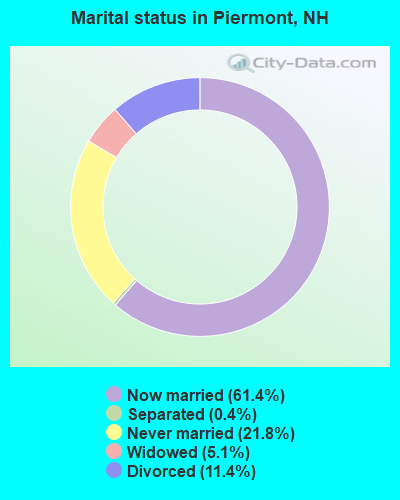
- Never married: 21.8%
- Now married: 61.4%
- Separated: 0.4%
- Widowed: 5.1%
- Divorced: 11.4%
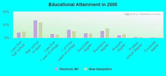
For population 25 years and over in Piermont:
- High school or higher: 89.5%
- Bachelor's degree or higher: 22.8%
- Graduate or professional degree: 9.0%
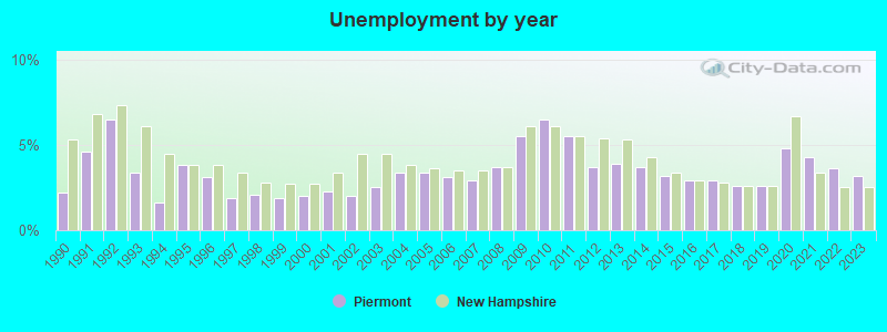
- Unemployed: 4.1%
- Mean travel time to work (commute): 31.8 minutes
| Here: | 10.7 |
| New Hampshire average: | 10.9 |


Graphs represent county-level data. Detailed 2008 Election Results
Religion statistics for Piermont, NH (based on Grafton County data)


| Religion | Adherents | Congregations |
|---|---|---|
| Catholic | 9,503 | 12 |
| Mainline Protestant | 7,832 | 57 |
| Evangelical Protestant | 1,494 | 29 |
| Other | 1,320 | 11 |
| None | 68,969 | - |
Food Environment Statistics:
| This county: | 3.87 / 10,000 pop. |
| New Hampshire: | 2.14 / 10,000 pop. |
| Grafton County: | 0.23 / 10,000 pop. |
| New Hampshire: | 0.15 / 10,000 pop. |
| This county: | 1.29 / 10,000 pop. |
| New Hampshire: | 1.78 / 10,000 pop. |
| Here: | 6.45 / 10,000 pop. |
| New Hampshire: | 4.02 / 10,000 pop. |
| Grafton County: | 14.41 / 10,000 pop. |
| New Hampshire: | 9.70 / 10,000 pop. |
| This county: | 7.2% |
| New Hampshire: | 7.6% |
| Grafton County: | 22.9% |
| New Hampshire: | 24.4% |
| Here: | 15.9% |
| New Hampshire: | 15.9% |
Strongest AM radio stations in Piermont:
- WTWN (1100 AM; daytime; 5 kW; WELLS RIVER, VT; Owner: PUFFER BROADCASTING, INC.)
- WPNH (1300 AM; 5 kW; PLYMOUTH, NH; Owner: NORTHEAST COMMUNICATIONS CORPORATION)
- WRKO (680 AM; 50 kW; BOSTON, MA; Owner: ENTERCOM BOSTON LICENSE, LLC)
- WNTK (1020 AM; 10 kW; NEWPORT, NH; Owner: KOOR COMMUNICATIONS, INC.)
- WCHP (760 AM; 35 kW; CHAMPLAIN, NY; Owner: CHAMPLAIN RADIO, INC.)
- WNNZ (640 AM; 50 kW; WESTFIELD, MA; Owner: CLEAR CHANNEL BROADCASTING LICENSES, INC.)
- WDEV (550 AM; 5 kW; WATERBURY, VT; Owner: RADIO VERMONT, INC.)
- WCRN (830 AM; 50 kW; WORCESTER, MA; Owner: CARTER BROADCASTING CORPORATION)
- WEEI (850 AM; 50 kW; BOSTON, MA; Owner: ENTERCOM BOSTON LICENSE, LLC)
- WGY (810 AM; 50 kW; SCHENECTADY, NY; Owner: CLEAR CHANNEL BROADCASTING LICENSES, INC.)
- WKOX (1200 AM; 50 kW; FRAMINGHAM, MA; Owner: CAPSTAR TX LIMITED PARTNERSHIP)
- WBZ (1030 AM; 50 kW; BOSTON, MA; Owner: INFINITY BROADCASTING OPERATIONS, INC.)
- WBIX (1060 AM; 40 kW; NATICK, MA; Owner: LANGER BROADCASTING CORPORATION)
Strongest FM radio stations in Piermont:
- WVFM (105.7 FM; CAMPTON, NH; Owner: DEVON BROADCASTING COMPANY, INC.)
- WPKQ (103.7 FM; NORTH CONWAY, NH; Owner: CITADEL BROADCASTING COMPANY)
- WHOM (94.9 FM; MT. WASHINGTON, NH; Owner: CITADEL BROADCASTING COMPANY)
- WEVH (91.3 FM; HANOVER, NH; Owner: NEW HAMPSHIRE PUBLIC RADIO INC)
- WPNH-FM (100.1 FM; PLYMOUTH, NH; Owner: NORTHEAST COMMUNICATIONS CORPORATION)
- WSCY (106.9 FM; MOULTONBOROUGH, NH; Owner: NORTHEAST COMMUNICATIONS CORPORATION)
- WEBK (105.3 FM; KILLINGTON, VT; Owner: 6 JOHNSON ROAD LICENSES, INC.)
- WJJR (98.1 FM; RUTLAND, VT; Owner: 6 JOHNSON ROAD LICENSES, INC.)
- WZRT (97.1 FM; RUTLAND, VT; Owner: CAPSTAR TX LIMITED PARTNERSHIP)
- WHDQ (106.1 FM; CLAREMONT, NH; Owner: GREAT NORTHERN RADIO, L.L.C.)
- WYKR-FM (101.3 FM; HAVERHILL, NH; Owner: PUFFER BROADCASTING, INC.)
- WGMT (97.7 FM; LYNDON, VT; Owner: VERMONT BROADCAST ASSOCIATES, INC.)
- WCVT (101.7 FM; STOWE, VT; Owner: RADIO VERMONT CLASSICS, L.L.C.)
- WVPR (89.5 FM; WINDSOR, VT; Owner: VERMONT PUBLIC RADIO)
- WDEV-FM (96.1 FM; WARREN, VT; Owner: RADIO VERMONT, INC.)
- WGLV (91.7 FM; WOODSTOCK, VT; Owner: CHRISTIAN MINISTRIES INC)
- WHDQ-FM1 (106.1 FM; RUTLAND, VT; Owner: GREAT NORTHERN RADIO, L.L.C.)
- WMTK (106.3 FM; LITTLETON, NH; Owner: VERMONT BROADCAST ASSOCIATES, INC.)
- WVPS (107.9 FM; BURLINGTON, VT; Owner: VERMONT PUBLIC RADIO)
- WLKC (103.3 FM; WATERBURY, VT; Owner: RADIO BROADCASTING SERVICES, INC.)
TV broadcast stations around Piermont:
- W15BK (Channel 15; HANOVER, NH; Owner: UNIVERSITY OF NEW HAMPSHIRE)
Medal of Honor Recipients
Medal of Honor Recipients born in Piermont: Ira H. Evans, Nathaniel C. Barker.
Piermont fatal accident list:
Jun 19, 2002 01:40 AM, Sr-10, Vehicles: 2, Persons: 3, Fatalities: 2, Drunk persons involved: 2
May 7, 1994 05:05 PM, Route 105s, Vehicles: 2, Persons: 6, Fatalities: 1
Dec 19, 1992 08:00 PM, Sr10, Vehicles: 2, Persons: 4, Fatalities: 1
- National Bridge Inventory (NBI) Statistics
- 10Number of bridges
- 79ft / 23.5mTotal length
- $31,420,000Total costs
- 8,250Total average daily traffic
- 450Total average daily truck traffic
- 12,206Total future (year 2042) average daily traffic
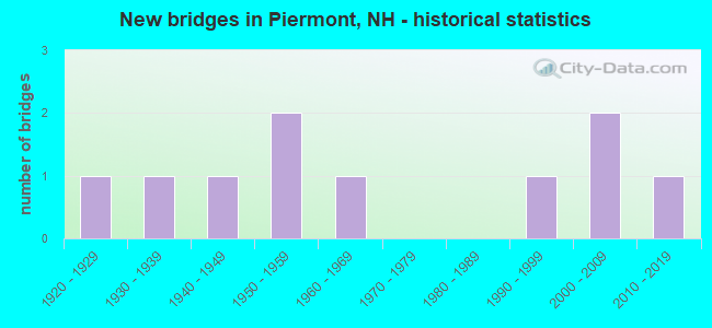
- New bridges - historical statistics
- 11920-1929
- 11930-1939
- 11940-1949
- 21950-1959
- 11960-1969
- 11990-1999
- 22000-2009
- 12010-2019
FCC Registered Broadcast Land Mobile Towers:
1- 1000 Cape Moonshine Road (Lat: 43.950278 Lon: -71.966389), Type: Building, Structure height: 5 m, Call Sign: WRPN576,
Assigned Frequencies: 462.825 MHz, Grant Date: 03/01/2022, Expiration Date: 03/01/2032, Certifier: Jed Dorfman, Registrant: Visiplex, 1287 Barclay Boulevard, Buffalo Grove, IL 60089, Phone: (847) 229-0250, Email:
FCC Registered Microwave Towers:
1- STATION, On Us Route 10 1.35 Mi N Of (Lat: 43.989778 Lon: -72.075639), Overall height: 22.9 m, Call Sign: KZW76,
Assigned Frequencies: 6725.00 MHz, 6795.00 MHz, Grant Date: 01/31/2020, Expiration Date: 02/01/2030, Registrant: Utilities Technology Council, 2550 South Clark St., Suite 960, Arlington, VA 22202, Phone: (202) 833-6818, Email:
FCC Registered Amateur Radio Licenses:
6- Call Sign: K1CLD, Grant Date: 07/30/1997, Expiration Date: 07/30/2007, Cancellation Date: 07/31/2009, Registrant: William R Deal, Piermont, NH 03779
- Call Sign: KA1JSB, Licensee ID: L00185456, Grant Date: 12/17/1999, Expiration Date: 03/13/2010, Cancellation Date: 12/27/2000, Registrant: Donald A Smith, Piermont, NH 03779
- Call Sign: WB6MXL, Licensee ID: L00137149, Grant Date: 02/28/2014, Expiration Date: 05/24/2024, Registrant: Peter Erpelding, 255 River Rd, Piermont, NH 03779
- Call Sign: AB1BF, Previous Call Sign: KB1DLD, Licensee ID: L00541484, Grant Date: 09/12/2018, Expiration Date: 11/20/2028, Certifier: Gail M Schmitt, Registrant: Gail M Schmitt, 219 Church St, Piermont, NH 03779-3112
- Call Sign: KB1JCN, Licensee ID: L00605502, Grant Date: 11/05/2012, Expiration Date: 12/10/2022, Certifier: Brian K Rose, Registrant: Brian K Rose, Piermont, NH 03779
- Call Sign: KC1NGJ, Licensee ID: L02352965, Grant Date: 06/15/2020, Expiration Date: 06/15/2030, Certifier: Elisha Buhler, Registrant: Elisha Buhler, 187 Route 10, Piermont, NH 03779-3305
FAA Registered Aircraft:
1- Aircraft: ROBINSON HELICOPTER R44 (Category: Land, Seats: 4, Weight: Up to 12,499 Pounds), Engine: LYCOMING O-540-F1B5 (260 HP) (Reciprocating)
N-Number: 189MX, N189MX, N-189MX, Serial Number: 2194, Year manufactured: 2012, Airworthiness Date: 05/14/2012, Certificate Issue Date: 07/27/2012
Registrant (Individual): Peter Erpelding, 255 River Rd, Piermont, NH 03779, Other Owners: Engineering Otes
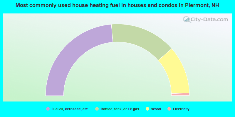
- 47.3%Fuel oil, kerosene, etc.
- 29.9%Bottled, tank, or LP gas
- 21.6%Wood
- 1.2%Electricity
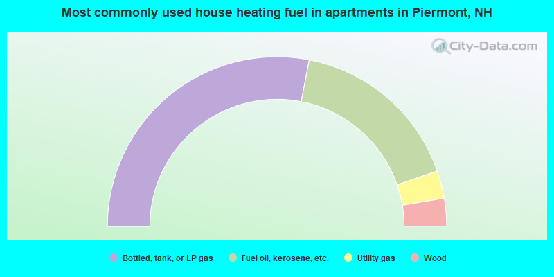
- 56.1%Bottled, tank, or LP gas
- 33.3%Fuel oil, kerosene, etc.
- 5.3%Utility gas
- 5.3%Wood
Piermont compared to New Hampshire state average:
- Unemployed percentage significantly below state average.
- Black race population percentage significantly below state average.
- Hispanic race population percentage significantly below state average.
- Foreign-born population percentage significantly below state average.
- Renting percentage below state average.
- Length of stay since moving in significantly above state average.
- Number of rooms per house significantly below state average.
- House age significantly below state average.
- Number of college students below state average.

|
Total of 1 patent application in 2008-2024.