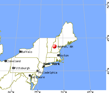
Hebron, New Hampshire
Hebron
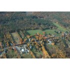
Hebron: GEORGE ROAD IN THE FALL HEBRON NH
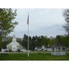
Hebron: Hebron village green in springtime

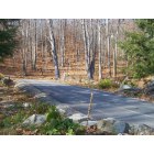
Hebron: ALONG GEORGE ROAD HEBRON NH
Hebron: ALONG GEORGE ROAD HEBRON NH
- see
18
more - add
your
Submit your own pictures of this town and show them to the world
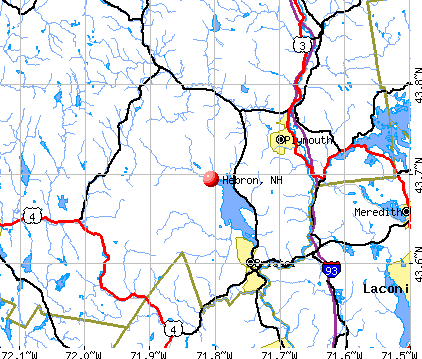
- OSM Map
- General Map
- Google Map
- MSN Map
Population change since 2000: +31.2%
| Males: 309 | |
| Females: 293 |
| Median resident age: | 55.1 years |
| New Hampshire median age: | 43.9 years |
Zip codes: 03241.
| Hebron: | $93,145 |
| NH: | $89,992 |
Estimated per capita income in 2022: $68,665 (it was $30,196 in 2000)
Hebron town income, earnings, and wages data
Estimated median house or condo value in 2022: $529,295 (it was $165,600 in 2000)
| Hebron: | $529,295 |
| NH: | $384,700 |
Mean prices in 2022: all housing units: $486,096; detached houses: $533,852; townhouses or other attached units: $375,744; in 2-unit structures: $230,260; in 3-to-4-unit structures: $242,363; in 5-or-more-unit structures: $588,257; mobile homes: $127,035
Detailed information about poverty and poor residents in Hebron, NH


- 57094.7%White alone
- 172.8%Hispanic
- 61.0%Two or more races
- 40.7%American Indian alone
- 30.5%Black alone
- 20.3%Asian alone

Races in Hebron detailed stats: ancestries, foreign born residents, place of birth
According to our research of New Hampshire and other state lists, there was 1 registered sex offender living in Hebron, New Hampshire as of May 23, 2024.
The ratio of all residents to sex offenders in Hebron is 602 to 1.
The ratio of registered sex offenders to all residents in this city is near the state average.
Full-time law enforcement employees in 2021, including police officers: 1 (1 officers - 1 male; 0 female).
| Officers per 1,000 residents here: | 1.57 |
| New Hampshire average: | 2.14 |
 Recent articles from our blog. Our writers, many of them Ph.D. graduates or candidates, create easy-to-read articles on a wide variety of topics.

 | NH town suggestions? Retirement (14 replies) |
| Bought a House near Colebrook. Moving up! (23 replies) |
| Retirement/Relocation (38 replies) |
| Towns with the Lowest Property Tax (47 replies) |
| Airplane Traffic and Noise - Seacoast, Dover and Exeter Areas (23 replies) |
| Socially conservative towns in NH (71 replies) |
Latest news from Hebron, NH collected exclusively by city-data.com from local newspapers, TV, and radio stations
Ancestries: English (41.0%), Irish (19.8%), French (14.4%), United States (9.4%), Scottish (8.3%), German (5.9%).
Current Local Time: EST time zone
Incorporated in 1792
Elevation: 623 feet
Land area: 16.8 square miles.
Population density: 36 people per square mile (very low).
11 residents are foreign born (1.1% Europe, 0.9% Asia, 0.4% Latin America).
| This town: | 2.4% |
| New Hampshire: | 4.4% |
| Hebron town: | 1.3% ($2,088) |
| New Hampshire: | 2.3% ($2,946) |
Nearest city with pop. 50,000+: Manchester, NH  (51.8 miles , pop. 107,006).
Nearest city with pop. 200,000+: Boston, MA (101.2 miles , pop. 589,141).
Nearest city with pop. 1,000,000+: Bronx, NY (224.0 miles , pop. 1,332,650).
Nearest cities:
), Latitude: 43.69 N, Longitude: 71.79 W
Area code commonly used in this area: 603


Single-family new house construction building permits:
- 2022: 10 buildings, average cost: $658,500
- 2021: 11 buildings, average cost: $259,200
- 2020: 5 buildings, average cost: $468,900
- 2019: 5 buildings, average cost: $457,000
- 2018: 2 buildings, average cost: $175,000
- 2017: 2 buildings, average cost: $175,000
- 2016: 3 buildings, average cost: $300,000
- 2015: 6 buildings, average cost: $799,200
- 2014: 2 buildings, average cost: $185,000
- 2013: 4 buildings, average cost: $253,800
- 2012: 3 buildings, average cost: $162,900
- 2011: 7 buildings, average cost: $339,700
- 2010: 8 buildings, average cost: $142,500
- 2009: 1 building, cost: $45,000
- 2008: 7 buildings, average cost: $114,300
- 2007: 7 buildings, average cost: $250,000
- 2006: 8 buildings, average cost: $303,300
- 2005: 13 buildings, average cost: $150,200
- 2004: 9 buildings, average cost: $166,700
- 2003: 10 buildings, average cost: $132,800
- 2002: 13 buildings, average cost: $130,700
- 2001: 6 buildings, average cost: $104,500
- 2000: 6 buildings, average cost: $104,500
- 1999: 5 buildings, average cost: $109,200
- 1998: 3 buildings, average cost: $101,700
- 1997: 11 buildings, average cost: $91,700


| Here: | 2.1% |
| New Hampshire: | 2.5% |


- Construction (9.6%)
- Health care (9.2%)
- Professional, scientific, technical services (7.3%)
- Educational services (6.2%)
- Accommodation & food services (5.4%)
- Public administration (5.4%)
- Finance & insurance (4.2%)

- Construction (18.4%)
- Professional, scientific, technical services (7.2%)
- Accommodation & food services (7.2%)
- Real estate & rental & leasing (6.4%)
- Agriculture, forestry, fishing & hunting (4.8%)
- Transportation equipment (4.8%)
- Machinery, equipment, supplies merchant wholesalers (4.8%)

- Health care (15.6%)
- Public administration (10.4%)
- Educational services (8.9%)
- Professional, scientific, technical services (7.4%)
- Finance & insurance (6.7%)
- Food (4.4%)
- Food & beverage stores (3.7%)

- Other management occupations, except farmers and farm managers (8.8%)
- Other production occupations, including supervisors (5.8%)
- Health technologists and technicians (5.0%)
- Building and grounds cleaning and maintenance occupations (4.6%)
- Other sales and related occupations, including supervisors (4.6%)
- Material recording, scheduling, dispatching, and distributing workers (3.8%)
- Secretaries and administrative assistants (3.8%)

- Building and grounds cleaning and maintenance occupations (8.0%)
- Other management occupations, except farmers and farm managers (7.2%)
- Other sales and related occupations, including supervisors (6.4%)
- Supervisors, construction and extraction workers (4.8%)
- Metal workers and plastic workers (4.0%)
- Painters and paperhangers (4.0%)
- Counselors, social workers, and other community and social service specialists (4.0%)

- Other management occupations, except farmers and farm managers (10.4%)
- Health technologists and technicians (9.6%)
- Other production occupations, including supervisors (9.6%)
- Secretaries and administrative assistants (7.4%)
- Registered nurses (5.9%)
- Other financial specialists (5.2%)
- Assemblers and fabricators (5.2%)
Average climate in Hebron, New Hampshire
Based on data reported by over 4,000 weather stations


(lower is better)

Air Quality Index (AQI) level in 2022 was 46.9. This is significantly better than average.
| City: | 46.9 |
| U.S.: | 72.6 |

Ozone [ppb] level in 2022 was 29.8. This is about average. Closest monitor was 6.1 miles away from the city center.
| City: | 29.8 |
| U.S.: | 33.3 |

Particulate Matter (PM2.5) [µg/m3] level in 2022 was 4.52. This is significantly better than average. Closest monitor was 6.6 miles away from the city center.
| City: | 4.52 |
| U.S.: | 8.11 |
Tornado activity:
Hebron-area historical tornado activity is slightly below New Hampshire state average. It is 65% smaller than the overall U.S. average.
On 5/11/1973, a category F2 (max. wind speeds 113-157 mph) tornado 11.9 miles away from the Hebron town center .
On 7/3/1972, a category F2 tornado 26.0 miles away from the town center injured 7 people and caused between $5000 and $50,000 in damages.
Earthquake activity:
Hebron-area historical earthquake activity is significantly above New Hampshire state average. It is 71% smaller than the overall U.S. average.On 4/20/2002 at 10:50:47, a magnitude 5.3 (5.3 ML, Depth: 3.0 mi, Class: Moderate, Intensity: VI - VII) earthquake occurred 110.5 miles away from the city center
On 10/7/1983 at 10:18:46, a magnitude 5.3 (5.1 MB, 5.3 LG, 5.1 ML) earthquake occurred 128.8 miles away from the city center
On 4/20/2002 at 10:50:47, a magnitude 5.2 (5.2 MB, 4.2 MS, 5.2 MW, 5.0 MW) earthquake occurred 110.6 miles away from the city center
On 1/19/1982 at 00:14:42, a magnitude 4.7 (4.5 MB, 4.7 MD, 4.5 LG, Class: Light, Intensity: IV - V) earthquake occurred 16.3 miles away from the city center
On 10/16/2012 at 23:12:25, a magnitude 4.7 (4.7 ML, Depth: 10.0 mi) earthquake occurred 56.9 miles away from Hebron center
On 8/21/1996 at 07:54:14, a magnitude 3.8 (3.8 LG, 3.6 LG, Depth: 6.2 mi, Class: Light, Intensity: II - III) earthquake occurred 40.2 miles away from the city center
Magnitude types: regional Lg-wave magnitude (LG), body-wave magnitude (MB), duration magnitude (MD), local magnitude (ML), surface-wave magnitude (MS), moment magnitude (MW)
Natural disasters:
The number of natural disasters in Grafton County (32) is a lot greater than the US average (15).Major Disasters (Presidential) Declared: 20
Emergencies Declared: 9
Causes of natural disasters: Floods: 16, Storms: 16, Hurricanes: 3, Snows: 3, Winter Storms: 3, Tropical Storms: 2, Blizzard: 1, Heavy Rain: 1, Ice Storm: 1, Landslide: 1, Snowfall: 1, Snowstorm: 1, Wind: 1, Other: 1 (Note: some incidents may be assigned to more than one category).
Colleges/universities with over 2000 students nearest to Hebron:
- Plymouth State University (about 7 miles; Plymouth, NH; Full-time enrollment: 4,838)
- Dartmouth College (about 26 miles; Hanover, NH; FT enrollment: 6,030)
- NHTI-Concord's Community College (about 35 miles; Concord, NH; FT enrollment: 2,865)
- Southern New Hampshire University (about 49 miles; Manchester, NH; FT enrollment: 16,552)
- Saint Anselm College (about 51 miles; Manchester, NH; FT enrollment: 2,059)
- Mount Washington College (about 53 miles; Manchester, NH; FT enrollment: 2,187)
- Norwich University (about 54 miles; Northfield, VT; FT enrollment: 4,221)
Points of interest:
Notable locations in Hebron: Camp Pasquaney (A), Camp Berea (B), Hebron Fire Department (C), Hebron Public Library (D). Display/hide their locations on the map
Church in Hebron: Union Congregational Church (A). Display/hide its location on the map
Cemeteries: Pratt Cemetery (1), Hebron Village Cemetery (2). Display/hide their locations on the map
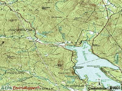
Streams, rivers, and creeks: Wise Brook (A), Georges Brook (B), Fretts Brook (C), Cockermouth River (D), Cilley Brook (E). Display/hide their locations on the map
Park in Hebron: Hebron Village Historic District (1). Display/hide its location on the map
Birthplace of: Eric Stokes (American football) - Football player.
Drinking water stations with addresses in Hebron and their reported violations in the past:
HILLSIDE INN CONDOS (Population served: 65, Groundwater):Past health violations:Past monitoring violations:
- MCL, Average - Between APR-2014 and JUN-2014, Contaminant: Gross Alpha, Excl. Radon and U
- OCCT/SOWT Study/Recommendation - In FEB-01-2009, Contaminant: Lead and Copper Rule. Follow-up actions: St Public Notif requested (MAR-09-2009), St Violation/Reminder Notice (MAR-09-2009), St Public Notif received (APR-08-2009), St Formal NOV issued (MAY-08-2009), St BCA signed (MAY-18-2009), St Compliance achieved (OCT-06-2009)
- Water Quality Parameter M/R - In JUL-01-2008, Contaminant: Lead and Copper Rule. Follow-up actions: St Violation/Reminder Notice (MAR-09-2009), St Compliance achieved (APR-13-2009)
- Water Quality Parameter M/R - In JAN-01-2006, Contaminant: Lead and Copper Rule. Follow-up actions: St Violation/Reminder Notice (SEP-29-2006), St Compliance achieved (OCT-09-2006)
| This town: | 2.2 people |
| New Hampshire: | 2.5 people |
| This town: | 70.1% |
| Whole state: | 66.3% |
| This town: | 6.0% |
| Whole state: | 8.3% |
No gay or lesbian households reported
| This town: | 2.8% |
| Whole state: | 6.5% |
| This town: | 2.0% |
| Whole state: | 2.8% |
For population 15 years and over in Hebron:

- Never married: 17.3%
- Now married: 64.3%
- Separated: 0.7%
- Widowed: 7.0%
- Divorced: 10.8%
For population 25 years and over in Hebron:
- High school or higher: 92.8%
- Bachelor's degree or higher: 31.5%
- Graduate or professional degree: 7.2%
- Unemployed: 1.1%
- Mean travel time to work (commute): 34.5 minutes


| Here: | 9.1 |
| New Hampshire average: | 10.9 |


Graphs represent county-level data. Detailed 2008 Election Results
Religion statistics for Hebron, NH (based on Grafton County data)


| Religion | Adherents | Congregations |
|---|---|---|
| Catholic | 9,503 | 12 |
| Mainline Protestant | 7,832 | 57 |
| Evangelical Protestant | 1,494 | 29 |
| Other | 1,320 | 11 |
| None | 68,969 | - |
Food Environment Statistics:
| This county: | 3.87 / 10,000 pop. |
| New Hampshire: | 2.14 / 10,000 pop. |
| Grafton County: | 0.23 / 10,000 pop. |
| New Hampshire: | 0.15 / 10,000 pop. |
| This county: | 1.29 / 10,000 pop. |
| State: | 1.78 / 10,000 pop. |
| This county: | 6.45 / 10,000 pop. |
| State: | 4.02 / 10,000 pop. |
| Here: | 14.41 / 10,000 pop. |
| New Hampshire: | 9.70 / 10,000 pop. |
| This county: | 7.2% |
| New Hampshire: | 7.6% |
| Grafton County: | 22.9% |
| New Hampshire: | 24.4% |
| Grafton County: | 15.9% |
| New Hampshire: | 15.9% |
Strongest AM radio stations in Hebron:
- WPNH (1300 AM; 5 kW; PLYMOUTH, NH; Owner: NORTHEAST COMMUNICATIONS CORPORATION)
- WEZS (1350 AM; 5 kW; LACONIA, NH; Owner: GARY W. HAMMOND)
- WNTK (1020 AM; 10 kW; NEWPORT, NH; Owner: KOOR COMMUNICATIONS, INC.)
- WRKO (680 AM; 50 kW; BOSTON, MA; Owner: ENTERCOM BOSTON LICENSE, LLC)
- WCRN (830 AM; 50 kW; WORCESTER, MA; Owner: CARTER BROADCASTING CORPORATION)
- WEEI (850 AM; 50 kW; BOSTON, MA; Owner: ENTERCOM BOSTON LICENSE, LLC)
- WNNZ (640 AM; 50 kW; WESTFIELD, MA; Owner: CLEAR CHANNEL BROADCASTING LICENSES, INC.)
- WKOX (1200 AM; 50 kW; FRAMINGHAM, MA; Owner: CAPSTAR TX LIMITED PARTNERSHIP)
- WASR (1420 AM; 5 kW; WOLFEBORO, NH; Owner: RADIO WOLFEBORO, INC.)
- WGIN (930 AM; 10 kW; ROCHESTER, NH; Owner: CAPSTAR TX LIMITED PARTNERSHIP)
- WBZ (1030 AM; 50 kW; BOSTON, MA; Owner: INFINITY BROADCASTING OPERATIONS, INC.)
- WBIX (1060 AM; 40 kW; NATICK, MA; Owner: LANGER BROADCASTING CORPORATION)
- WTWN (1100 AM; daytime; 5 kW; WELLS RIVER, VT; Owner: PUFFER BROADCASTING, INC.)
Strongest FM radio stations in Hebron:
- WPNH-FM (100.1 FM; PLYMOUTH, NH; Owner: NORTHEAST COMMUNICATIONS CORPORATION)
- WVFM (105.7 FM; CAMPTON, NH; Owner: DEVON BROADCASTING COMPANY, INC.)
- WSCY (106.9 FM; MOULTONBOROUGH, NH; Owner: NORTHEAST COMMUNICATIONS CORPORATION)
- WEVH (91.3 FM; HANOVER, NH; Owner: NEW HAMPSHIRE PUBLIC RADIO INC)
- WPKQ (103.7 FM; NORTH CONWAY, NH; Owner: CITADEL BROADCASTING COMPANY)
- WHOM (94.9 FM; MT. WASHINGTON, NH; Owner: CITADEL BROADCASTING COMPANY)
- WHDQ (106.1 FM; CLAREMONT, NH; Owner: GREAT NORTHERN RADIO, L.L.C.)
- WVPR (89.5 FM; WINDSOR, VT; Owner: VERMONT PUBLIC RADIO)
- WLKZ (104.9 FM; WOLFEBORO, NH; Owner: TELE-MEDIA COMPANY OF NEW HAMPSHIRE, L.L.C.)
- WNHI (93.3 FM; BELMONT, NH; Owner: CONCORD BROADCASTING, L.L.C.)
- WJJR (98.1 FM; RUTLAND, VT; Owner: 6 JOHNSON ROAD LICENSES, INC.)
- WZRT (97.1 FM; RUTLAND, VT; Owner: CAPSTAR TX LIMITED PARTNERSHIP)
- WEBK (105.3 FM; KILLINGTON, VT; Owner: 6 JOHNSON ROAD LICENSES, INC.)
- WNTK-FM (99.7 FM; NEW LONDON, NH; Owner: SHEILA E. VINIKOOR)
- WGLV (91.7 FM; WOODSTOCK, VT; Owner: CHRISTIAN MINISTRIES INC)
- WHDQ-FM1 (106.1 FM; RUTLAND, VT; Owner: GREAT NORTHERN RADIO, L.L.C.)
- WVRR (101.7 FM; NEWPORT, NH; Owner: CAPSTAR TX LIMITED PARTNERSHIP)
- WLNH-FM (98.3 FM; LACONIA, NH; Owner: WLNH RADIO, INC)
- WFTN-FM (94.1 FM; FRANKLIN, NH; Owner: NORTHEAST COMMUNICATIONS CORPORATION)
- WXXK (100.5 FM; LEBANON, NH; Owner: CAPSTAR TX LIMITED PARTNERSHIP)
TV broadcast stations around Hebron:
- WMTW-TV (Channel 8; POLAND SPRING, ME; Owner: WMTW BROADCAST GROUP, LLC)
- W15BK (Channel 15; HANOVER, NH; Owner: UNIVERSITY OF NEW HAMPSHIRE)
- WMEA-TV (Channel 26; BIDDEFORD, ME; Owner: MAINE PUBLIC BROADCASTING CORP.)
Hebron fatal accident list:
Aug 10, 2005 06:10 PM, Sr-3a, N Shore Rd, Lat: 43.704330, Lon: -71.769610, Vehicles: 2, Persons: 3, Fatalities: 1, Drunk persons involved: 1
Jan 22, 2000 10:37 AM, Sr-3a, Vehicles: 1, Persons: 1, Fatalities: 1
Apr 27, 2000 11:45 PM, Sr-3, Vehicles: 1, Persons: 2, Fatalities: 1
- National Bridge Inventory (NBI) Statistics
- 6Number of bridges
- 30ft / 8.6mTotal length
- $18,852,000Total costs
- 3,156Total average daily traffic
- 300Total average daily truck traffic
- 4,669Total future (year 2042) average daily traffic
FCC Registered Amateur Radio Licenses:
12 (See the full list of FCC Registered Amateur Radio Licenses in Hebron)FAA Registered Aircraft:
5- Aircraft: CESSNA 172M (Category: Land, Seats: 4, Weight: Up to 12,499 Pounds, Speed: 108 mph), Engine: LYCOMING 0-320 SERIES (180 HP) (4 Cycle)
N-Number: 20565, N20565, N-20565, Serial Number: 17261398, Year manufactured: 1973, Airworthiness Date: 02/05/1973, Certificate Issue Date: 06/14/2016
Registrant (LLC): Bmw Aviation LLC, 80 Indian Pt Rd, Hebron, NH 03241 - Aircraft: CESSNA 182Q (Category: Land, Seats: 4, Weight: Up to 12,499 Pounds, Speed: 112 mph), Engine: CONT MOTOR O-470 SERIES (230 HP) (Reciprocating)
N-Number: 735DX, N735DX, N-735DX, Serial Number: 18265352, Year manufactured: 1977, Airworthiness Date: 01/21/1977, Certificate Issue Date: 07/10/2019
Registrant (Individual): Joseph J Santamaria, 213 Hobart Hill Rd, Hebron, NH 03241 - Aircraft: CESSNA 170B (Category: Land, Seats: 4, Weight: Up to 12,499 Pounds, Speed: 105 mph), Engine: CONT MOTOR C145 SERIES (145 HP) (Reciprocating)
N-Number: 8380A, N8380A, N-8380A, Serial Number: 25232, Year manufactured: 1952, Airworthiness Date: 12/08/1955, Certificate Issue Date: 06/16/2011
Registrant (Individual): Henry D Lynch, 296 George Rd, Hebron, NH 03241 - Aircraft: BRAWN MALCOLM W ZODIAC 601XLB (Category: Land, Seats: 2, Weight: Up to 12,499 Pounds), Engine: CONT MOTOR O-200A (100 HP) (Reciprocating)
N-Number: 516YD, N516YD, N-516YD, Serial Number: 6-6731, Year manufactured: 2015, Airworthiness Date: 02/11/2016, Certificate Issue Date: 08/08/2014
Registrant (Individual): Malcolm W Brawn, Po Box 99, Hebron, NH 03241
Deregistered: Cancel Date: 12/08/2020 - Aircraft: TAYLORCRAFT BC12-D (Category: Land, Seats: 2, Weight: Up to 12,499 Pounds, Speed: 78 mph), Engine: CONT MOTOR A&C65 SERIES (65 HP) (Reciprocating)
N-Number: 96241, N96241, N-96241, Serial Number: 8541, Year manufactured: 1946, Airworthiness Date: 05/26/1956, Certificate Issue Date: 11/06/1995
Registrant (Individual): Mark N Connor, Po Box 420, Hebron, NH 03241
Deregistered: Cancel Date: 01/24/2018
2002 - 2018 National Fire Incident Reporting System (NFIRS) incidents
- Fire incident types reported to NFIRS in Hebron, NH
- 4744.8%Structure Fires
- 4744.8%Outside Fires
- 98.6%Other
- 21.9%Mobile Property/Vehicle Fires
 Based on the data from the years 2002 - 2018 the average number of fires per year is 6. The highest number of reported fires - 32 took place in 2016, and the least - 1 in 2004. The data has a dropping trend.
 When looking into fire subcategories, the most incidents belonged to: Structure Fires (44.8%), and Outside Fires (44.8%).
- 79.4%Fuel oil, kerosene, etc.
- 8.6%Wood
- 6.3%Bottled, tank, or LP gas
- 4.6%Electricity
- 1.1%Utility gas

- 63.6%Fuel oil, kerosene, etc.
- 27.3%Bottled, tank, or LP gas
- 9.1%Wood
Hebron compared to New Hampshire state average:
- Unemployed percentage significantly below state average.
- Black race population percentage below state average.
- Median age significantly above state average.
- Foreign-born population percentage significantly below state average.
- Renting percentage below state average.
- Length of stay since moving in significantly above state average.
- Number of rooms per house significantly below state average.
- House age significantly below state average.