Hermiston, Oregon
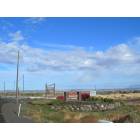
Hermiston: Herminston, Oregon
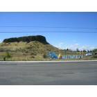
Hermiston: Landmark of City the Butte, overlooking the new Pool Facility
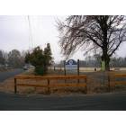
Hermiston: Newest Park in the City
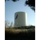
Hermiston: Hermiston Water Tower
- add
your
Submit your own pictures of this city and show them to the world
- OSM Map
- General Map
- Google Map
- MSN Map
Population change since 2000: +47.7%
| Males: 9,717 | |
| Females: 9,706 |
| Median resident age: | 31.9 years |
| Oregon median age: | 40.5 years |
Zip codes: 97838.
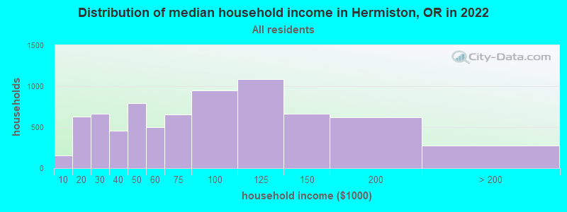
| Hermiston: | $71,728 |
| OR: | $75,657 |
Estimated per capita income in 2022: $30,004 (it was $17,075 in 2000)
Hermiston city income, earnings, and wages data
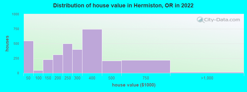
Estimated median house or condo value in 2022: $296,879 (it was $92,100 in 2000)
| Hermiston: | $296,879 |
| OR: | $475,600 |
Mean prices in 2022: all housing units: $246,141; detached houses: $273,661; townhouses or other attached units: $167,504; mobile homes: $93,632
Median gross rent in 2022: $1,018.
(11.2% for White Non-Hispanic residents, 12.2% for Hispanic or Latino residents, 7.4% for American Indian residents, 3.3% for other race residents, 8.5% for two or more races residents)
Detailed information about poverty and poor residents in Hermiston, OR


- 10,51854.5%Hispanic
- 7,83440.6%White alone
- 8674.5%Two or more races
- 2521.3%Black alone
- 1290.7%Asian alone
- 420.2%American Indian alone
- 320.2%Native Hawaiian and Other
Pacific Islander alone - 50.03%Other race alone
Races in Hermiston detailed stats: ancestries, foreign born residents, place of birth
According to our research of Oregon and other state lists, there were 5 registered sex offenders living in Hermiston, Oregon as of May 02, 2024.
The ratio of all residents to sex offenders in Hermiston is 3,424 to 1.
The ratio of registered sex offenders to all residents in this city is lower than the state average.
Type |
2009 |
2010 |
2011 |
2012 |
2013 |
2014 |
2015 |
2016 |
2017 |
2018 |
2019 |
2020 |
2021 |
2022 |
|---|---|---|---|---|---|---|---|---|---|---|---|---|---|---|
| Murders (per 100,000) | 0 (0.0) | 1 (6.0) | 1 (5.9) | 0 (0.0) | 0 (0.0) | 0 (0.0) | 1 (5.8) | 1 (5.8) | 1 (5.8) | 1 (5.7) | 0 (0.0) | 1 (5.6) | 1 (5.6) | 0 (0.0) |
| Rapes (per 100,000) | 3 (19.3) | 10 (59.7) | 2 (11.8) | 4 (23.4) | 6 (34.9) | 5 (29.1) | 5 (29.0) | 5 (28.9) | 3 (17.3) | 2 (11.4) | 4 (22.5) | 8 (44.7) | 4 (22.3) | 10 (51.4) |
| Robberies (per 100,000) | 11 (70.8) | 9 (53.7) | 14 (82.7) | 9 (52.8) | 9 (52.3) | 12 (69.8) | 4 (23.2) | 3 (17.4) | 4 (23.0) | 7 (40.0) | 8 (45.0) | 8 (44.7) | 12 (67.0) | 9 (46.3) |
| Assaults (per 100,000) | 36 (231.6) | 40 (238.9) | 29 (171.4) | 11 (64.5) | 3 (17.4) | 21 (122.2) | 18 (104.5) | 23 (133.1) | 41 (235.9) | 33 (188.4) | 42 (236.2) | 21 (117.3) | 34 (190.0) | 38 (195.5) |
| Burglaries (per 100,000) | 108 (694.8) | 116 (692.7) | 154 (910.0) | 118 (691.7) | 96 (557.7) | 69 (401.6) | 51 (296.2) | 57 (329.9) | 56 (322.3) | 86 (491.0) | 67 (376.8) | 54 (301.7) | 70 (391.1) | 43 (221.2) |
| Thefts (per 100,000) | 500 (3,217) | 542 (3,237) | 548 (3,238) | 378 (2,216) | 404 (2,347) | 362 (2,107) | 388 (2,253) | 368 (2,130) | 402 (2,313) | 466 (2,660) | 455 (2,559) | 347 (1,939) | 392 (2,190) | 506 (2,603) |
| Auto thefts (per 100,000) | 47 (302.4) | 21 (125.4) | 63 (372.3) | 55 (322.4) | 75 (435.7) | 38 (221.1) | 37 (214.9) | 30 (173.6) | 45 (259.0) | 47 (268.3) | 32 (180.0) | 40 (223.5) | 41 (229.1) | 56 (288.1) |
| Arson (per 100,000) | 2 (12.9) | 2 (11.9) | 0 (0.0) | 3 (17.6) | 1 (5.8) | 3 (17.5) | 1 (5.8) | 3 (17.4) | 3 (17.3) | 3 (17.1) | 2 (11.2) | 4 (22.4) | 5 (27.9) | 5 (25.7) |
| City-Data.com crime index | 284.5 | 311.6 | 303.4 | 210.3 | 214.8 | 198.7 | 190.8 | 188.7 | 215.2 | 232.5 | 221.9 | 200.4 | 220.5 | 236.8 |
The City-Data.com crime index weighs serious crimes and violent crimes more heavily. Higher means more crime, U.S. average is 246.1. It adjusts for the number of visitors and daily workers commuting into cities.
Crime rate in Hermiston detailed stats: murders, rapes, robberies, assaults, burglaries, thefts, arson
Full-time law enforcement employees in 2021, including police officers: 32 (28 officers - 25 male; 3 female).
| Officers per 1,000 residents here: | 1.56 |
| Oregon average: | 1.48 |
 Recent articles from our blog. Our writers, many of them Ph.D. graduates or candidates, create easy-to-read articles on a wide variety of topics.

 | Hermiston vs. La Grande? (22 replies) |
| Hermiston, OR... good schools? Safe area to raise a family? (5 replies) |
| Produce at Farmer's Markets (20 replies) |
| Is the Oregon Coast liberal? (53 replies) |
| Road trip to Oregon (need suggestions) (25 replies) |
| Why can't you pump your own gas in Oregon? (128 replies) |
Latest news from Hermiston, OR collected exclusively by city-data.com from local newspapers, TV, and radio stations
Ancestries: German (5.4%), English (5.0%), American (4.9%), Irish (2.6%), Norwegian (1.6%), European (1.0%).
Current Local Time: PST time zone
Incorporated in 1907
Elevation: 457 feet
Land area: 6.46 square miles.
Population density: 3,005 people per square mile (average).
3,604 residents are foreign born (16.9% Latin America).
| This city: | 18.6% |
| Oregon: | 9.8% |
Median real estate property taxes paid for housing units with mortgages in 2022: $3,388 (1.1%)
Median real estate property taxes paid for housing units with no mortgage in 2022: $3,013 (1.2%)
Nearest city with pop. 50,000+: Kennewick, WA  (25.9 miles , pop. 54,693).
Nearest city with pop. 200,000+: Portland, OR (163.3 miles , pop. 529,121).
Nearest city with pop. 1,000,000+: Los Angeles, CA (814.5 miles , pop. 3,694,820).
Nearest cities:
), ), )Latitude: 45.84 N, Longitude: 119.29 W
Daytime population change due to commuting: -2,128 (-11.0%)
Workers who live and work in this city: 4,090 (40.4%)
Area code: 541
Hermiston, Oregon accommodation & food services, waste management - Economy and Business Data
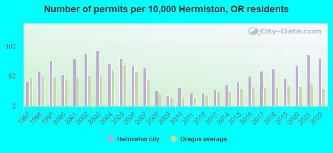
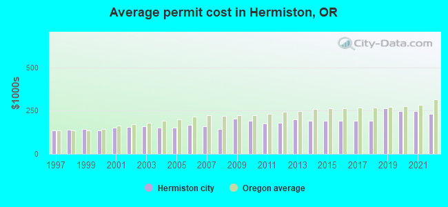
Single-family new house construction building permits:
- 2022: 105 buildings, average cost: $230,900
- 2021: 113 buildings, average cost: $247,600
- 2020: 88 buildings, average cost: $247,600
- 2019: 62 buildings, average cost: $264,400
- 2018: 82 buildings, average cost: $191,900
- 2017: 77 buildings, average cost: $191,900
- 2016: 66 buildings, average cost: $191,900
- 2015: 54 buildings, average cost: $191,900
- 2014: 47 buildings, average cost: $191,900
- 2013: 36 buildings, average cost: $199,200
- 2012: 30 buildings, average cost: $177,800
- 2011: 29 buildings, average cost: $176,300
- 2010: 42 buildings, average cost: $189,900
- 2009: 23 buildings, average cost: $203,600
- 2008: 35 buildings, average cost: $143,800
- 2007: 84 buildings, average cost: $158,300
- 2006: 89 buildings, average cost: $169,100
- 2005: 104 buildings, average cost: $150,900
- 2004: 94 buildings, average cost: $151,000
- 2003: 122 buildings, average cost: $160,800
- 2002: 116 buildings, average cost: $156,000
- 2001: 104 buildings, average cost: $151,300
- 2000: 70 buildings, average cost: $136,400
- 1999: 100 buildings, average cost: $144,200
- 1998: 77 buildings, average cost: $140,200
- 1997: 55 buildings, average cost: $135,900
| Here: | 4.1% |
| Oregon: | 3.9% |
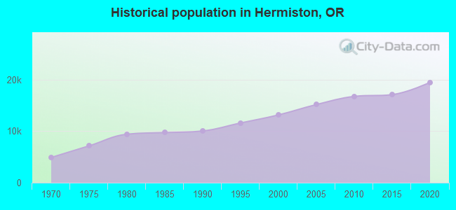
Population change in the 1990s: +2,768 (+26.7%).
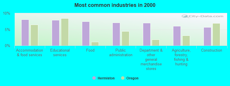
- Accommodation & food services (8.1%)
- Educational services (7.8%)
- Food (7.4%)
- Public administration (7.1%)
- Department & other general merchandise stores (7.0%)
- Agriculture, forestry, fishing & hunting (6.0%)
- Construction (5.7%)
- Agriculture, forestry, fishing & hunting (10.4%)
- Department & other general merchandise stores (8.6%)
- Construction (8.1%)
- Food (7.2%)
- Public administration (6.5%)
- Accommodation & food services (6.4%)
- Rail transportation (4.5%)
- Educational services (12.8%)
- Accommodation & food services (10.1%)
- Health care (9.2%)
- Food (7.6%)
- Public administration (7.6%)
- Finance & insurance (5.3%)
- Department & other general merchandise stores (5.0%)
- Other production occupations, including supervisors (5.5%)
- Laborers and material movers, hand (5.5%)
- Building and grounds cleaning and maintenance occupations (4.5%)
- Other sales and related occupations, including supervisors (3.9%)
- Driver/sales workers and truck drivers (3.6%)
- Agricultural workers, including supervisors (3.3%)
- Electrical equipment mechanics and other installation, maintenance, and repair workers, including supervisors (3.0%)
- Laborers and material movers, hand (7.3%)
- Agricultural workers, including supervisors (5.7%)
- Other production occupations, including supervisors (5.7%)
- Driver/sales workers and truck drivers (5.6%)
- Electrical equipment mechanics and other installation, maintenance, and repair workers, including supervisors (5.5%)
- Other sales and related occupations, including supervisors (3.9%)
- Vehicle and mobile equipment mechanics, installers, and repairers (3.9%)

- Building and grounds cleaning and maintenance occupations (6.1%)
- Secretaries and administrative assistants (5.9%)
- Other production occupations, including supervisors (5.3%)
- Cashiers (5.3%)
- Information and record clerks, except customer service representatives (5.0%)
- Other office and administrative support workers, including supervisors (4.8%)
- Preschool, kindergarten, elementary, and middle school teachers (4.6%)
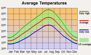
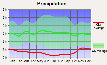
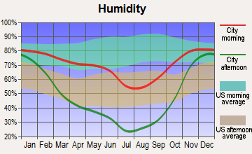
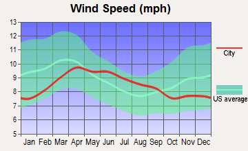
Average climate in Hermiston, Oregon
Based on data reported by over 4,000 weather stations
|
|

(lower is better)
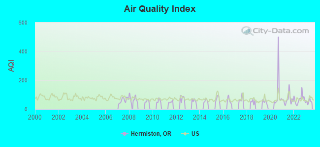
Air Quality Index (AQI) level in 2023 was 52.5. This is better than average.
| City: | 52.5 |
| U.S.: | 72.6 |
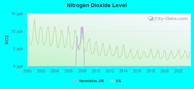
Nitrogen Dioxide (NO2) [ppb] level in 2007 was 7.16. This is significantly worse than average. Closest monitor was 1.6 miles away from the city center.
| City: | 7.16 |
| U.S.: | 5.11 |
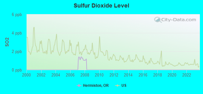
Sulfur Dioxide (SO2) [ppb] level in 2007 was 1.22. This is better than average. Closest monitor was 1.6 miles away from the city center.
| City: | 1.22 |
| U.S.: | 1.51 |
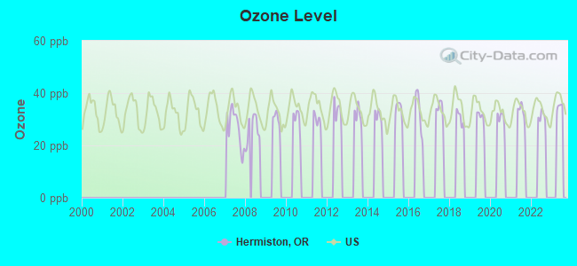
Ozone [ppb] level in 2008 was 26.3. This is better than average. Closest monitor was 1.6 miles away from the city center.
| City: | 26.3 |
| U.S.: | 33.3 |
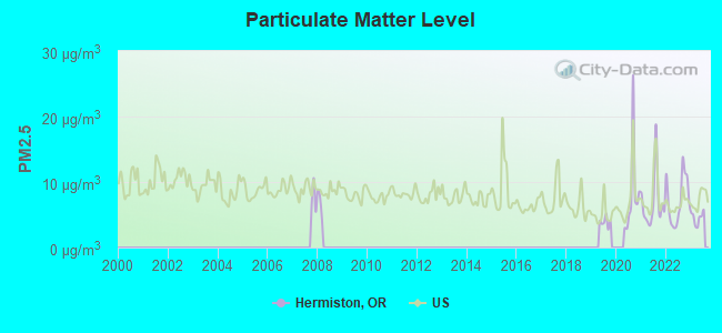
Particulate Matter (PM2.5) [µg/m3] level in 2023 was 4.55. This is significantly better than average. Closest monitor was 0.4 miles away from the city center.
| City: | 4.55 |
| U.S.: | 8.11 |
Earthquake activity:
Hermiston-area historical earthquake activity is significantly above Oregon state average. It is 1337% greater than the overall U.S. average.On 4/13/1949 at 19:55:42, a magnitude 7.0 (7.0 UK, Class: Major, Intensity: VIII - XII) earthquake occurred 181.1 miles away from the city center, causing $80,000,000 total damage
On 2/28/2001 at 18:54:32, a magnitude 6.8 (6.5 MB, 6.6 MS, 6.8 MW, Class: Strong, Intensity: VII - IX) earthquake occurred 178.9 miles away from the city center, causing $2,000,000,000 total damage and $305,000,000 insured losses
On 10/28/1983 at 14:06:06, a magnitude 7.3 (6.2 MB, 7.3 MS, 7.0 MW) earthquake occurred 295.0 miles away from Hermiston center, causing 2 deaths (2 shaking deaths) and 3 injuries, causing $15,000,000 total damage
On 2/28/2001 at 18:54:32, a magnitude 6.8 (6.8 MD, Depth: 32.2 mi) earthquake occurred 186.9 miles away from the city center
On 10/3/1915 at 06:52:48, a magnitude 7.6 (7.6 UK) earthquake occurred 380.3 miles away from Hermiston center
On 4/29/1965 at 15:28:43, a magnitude 6.6 (6.6 UK) earthquake occurred 177.0 miles away from Hermiston center, causing $28,000,000 total damage
Magnitude types: body-wave magnitude (MB), duration magnitude (MD), surface-wave magnitude (MS), moment magnitude (MW)
Natural disasters:
The number of natural disasters in Umatilla County (10) is smaller than the US average (15).Major Disasters (Presidential) Declared: 5
Emergencies Declared: 2
Causes of natural disasters: Floods: 5, Storms: 3, Landslides: 2, Mudslides: 2, Winter Storms: 2, Drought: 1, Fire: 1, Heavy Rain: 1, Hurricane: 1, Other: 1 (Note: some incidents may be assigned to more than one category).
Hospitals and medical centers in Hermiston:
- GOOD SHEPHERD MEDICAL CENTER (Government - Hospital District or Authority, provides emergency services, 610 NW 11TH STREET)
- VANGE JOHN MEMORIAL HOSPICE (645 WEST ORCHARD AVENUE, SUITE 600)
- HERMISTON GOOD SAMARITAN (970 JUNIPER AVENUE WEST)
- REGENCY HERMISTON NURSING AND REHAB CENTER (970 W JUNIPER AVENUE)
- HERMISTON COMMUNITY DIALYSIS CENTER (1155 WEST LINDA AVE SUITE A)
- TLC HOME HEALTH (1050 W ELM STREET, SUITE 220)
Airports and heliports located in Hermiston:
- Hermiston Municipal Airport (HRI) (Runways: 1, Air Taxi Ops: 500, Itinerant Ops: 8,300, Local Ops: 16,000, Military Ops: 50)
- Good Shepherd Hospital Heliport (OG09)
Colleges/universities with over 2000 students nearest to Hermiston:
- Columbia Basin College (about 30 miles; Pasco, WA; Full-time enrollment: 5,111)
- Walla Walla Community College (about 52 miles; Walla Walla, WA; FT enrollment: 4,263)
- Eastern Oregon University (about 69 miles; La Grande, OR; FT enrollment: 3,127)
- Yakima Valley Community College (about 79 miles; Yakima, WA; FT enrollment: 3,632)
- Central Washington University (about 101 miles; Ellensburg, WA; FT enrollment: 10,960)
- Lewis-Clark State College (about 116 miles; Lewiston, ID; FT enrollment: 3,199)
- Washington State University (about 120 miles; Pullman, WA; FT enrollment: 25,055)
Public high schools in Hermiston:
- HERMISTON HIGH SCHOOL (Students: 1,413, Location: 600 S 1ST ST, Grades: 9-12)
- INNOVATIVE LEARNING CENTER (Students: 139, Location: 581 S 1ST ST, Grades: KG-12)
Private high schools in Hermiston:
Public elementary/middle schools in Hermiston:
- SANDSTONE MIDDLE SCHOOL (Students: 656, Location: 400 NE 10TH ST, Grades: 6-8)
- SUNSET ELEMENTARY SCHOOL (Students: 490, Location: 300 E CATHERINE AVE, Grades: KG-5)
- WEST PARK ELEMENTARY SCHOOL (Students: 474, Location: 555 SW 7TH ST, Grades: KG-5)
- ARMAND LARIVE MIDDLE SCHOOL (Students: 457, Location: 1497 SW 9TH ST, Grades: 6-8)
- HIGHLAND HILLS ELEMENTARY SCHOOL (Students: 449, Location: 450 SE 10TH ST, Grades: KG-5)
- ROCKY HEIGHTS ELEMENTARY SCHOOL (Students: 440, Location: 650 W STANDARD AVE, Grades: KG-5)
- DESERT VIEW ELEMENTARY SCHOOL (Students: 429, Location: 1225 SW 9TH, Grades: KG-5)
Library in Hermiston:
- HERMISTON PUBLIC LIBRARY (Operating income: $633,957; Location: 235 E GLADYS AVE; 35,333 books; 3,452 e-books; 5,379 audio materials; 2,499 video materials; 1 local licensed databases; 27 state licensed databases; 37 other licensed databases; 36 print serial subscriptions; 1 electronic serial subscriptions)
User-submitted facts and corrections:
- Add to: Strongest FM Radio Stations KLTB (92.1; Pilot Rock, OR; Owner: Bruton Broadcasting LLC) It was built July '06
Points of interest:
Notable locations in Hermiston: Umatilla County Fairgrounds (A), Hermiston Rodeo Grounds (B), Hermiston Wastewater Treatment Plant (C), Cornell Place (D), Hermiston Fire and Emergency Services Station 1 Headquarters (E), Department of Motor Vehicles Hermiston (F), Hermiston Public Library (G), Hermiston City Hall (H), Hermiston Public Works Department (I), Hermiston Municipal Court (J). Display/hide their locations on the map
Parks in Hermiston include: Belt Park (1), Butte Park (2), Highland Park (3), Northside Park (4), Sunset Park (5), Volunteer Park (6), Doctor Belt Park (7), Victory Square Park (8), Hodge Park (9). Display/hide their locations on the map
Hotels: Hermiston Inn Best Western (2255 South Highway 395), Oak Tree Inn (1110 Southeast 4th Street), Oxford Suites (1050 North 1st Street), Oxford Suites - Hermiston (1050 N 1st), Economy Inn of Hermiston (835 North 1st Street), J & L Motel (425 North 1st Street).
Court: Hermiston City - Municipal Court (330 South 1st Street).
Birthplace of: Jared Zabransky - Quarterback, Jim Stuart - Football player.
Drinking water stations with addresses in Hermiston and their reported violations in the past:
HERMISTON, CITY OF (Population served: 15,410, Surface water):Past monitoring violations:SPACE AGE FUEL (Population served: 500, Groundwater):
- Monitoring and Reporting (DBP) - Between APR-2014 and JUN-2014, Contaminant: TTHM
- Monitoring and Reporting (DBP) - Between APR-2014 and JUN-2014, Contaminant: Total Haloacetic Acids (HAA5)
- Monitoring and Reporting (DBP) - Between JAN-2014 and MAR-2014, Contaminant: TTHM
- Monitoring and Reporting (DBP) - Between JAN-2014 and MAR-2014, Contaminant: Total Haloacetic Acids (HAA5)
- Monitoring, Turbidity (Enhanced SWTR) - In AUG-2013, Contaminant: IESWTR. Follow-up actions: St Compliance achieved (OCT-02-2013)
- 22 regular monitoring violations
- 13 other older monitoring violations
Past health violations:CHARLES TRACTS WATER COMPANY (Population served: 249, Groundwater):Past monitoring violations:
- MCL, Single Sample - Between APR-2013 and JUN-2013, Contaminant: Nitrate. Follow-up actions: St AO (w/o penalty) issued (APR-10-2013), St Public Notif requested (JUL-18-2013), St Public Notif received (SEP-04-2013), St Compliance achieved (JAN-02-2014)
- MCL, Single Sample - Between JAN-2013 and MAR-2013, Contaminant: Nitrate. Follow-up actions: St Public Notif requested (MAR-22-2013), St AO (w/o penalty) issued (APR-10-2013), St Compliance achieved (JAN-02-2014)
- MCL, Single Sample - Between OCT-2012 and DEC-2012, Contaminant: Nitrate. Follow-up actions: St Public Notif requested (DEC-21-2012), St Violation/Reminder Notice (DEC-31-2012), St AO (w/o penalty) issued (APR-10-2013), St Compliance achieved (JAN-02-2014)
- MCL, Acute (TCR) - Between APR-2012 and JUN-2012, Contaminant: Coliform. Follow-up actions: St Public Notif received (MAY-10-2012), St Public Notif requested (MAY-10-2012), St Violation/Reminder Notice (2 times from MAY-30-2012 to JUN-26-2012), St Compliance achieved (DEC-21-2012)
- MCL, Average - Between JAN-2012 and JUN-2012, Contaminant: Nitrate. Follow-up actions: St Public Notif received (MAY-14-2012), St Public Notif requested (MAY-14-2012), St Violation/Reminder Notice (JUN-25-2012), St AO (w/o penalty) issued (APR-10-2013), St Compliance achieved (JAN-02-2014)
- MCL, Acute (TCR) - Between APR-2010 and JUN-2010, Contaminant: Coliform. Follow-up actions: St Public Notif received (JUN-23-2010), St Public Notif requested (JUN-24-2010), St Violation/Reminder Notice (AUG-02-2010), St Compliance achieved (JUL-22-2011)
- 7 other older health violations
- Monitoring, Source Water (GWR) - In JUN-01-2010, Contaminant: E. COLI. Follow-up actions: St Violation/Reminder Notice (AUG-02-2010), St Compliance achieved (DEC-21-2012)
- Monitoring, Source Water (GWR) - In JUN-01-2010, Contaminant: E. COLI. Follow-up actions: St Violation/Reminder Notice (AUG-02-2010), St Compliance achieved (DEC-21-2012)
- 3 routine major monitoring violations
- 2 regular monitoring violations
Past monitoring violations:DUN-ROLLIN MOBILE HOME PARK (Population served: 130, Groundwater):
- 6 routine major monitoring violations
- 104 regular monitoring violations
Past monitoring violations:CHART SUBDIVISION (Population served: 125, Groundwater):
- Follow-up Or Routine LCR Tap M/R - In JAN-01-2014, Contaminant: Lead and Copper Rule
- 10 routine major monitoring violations
- One minor monitoring violation
- 52 regular monitoring violations
Past health violations:SPOUT SPRINGS WATER BOARD (Population served: 100, Groundwater):Past monitoring violations:
- MCL, Monthly (TCR) - In AUG-2009, Contaminant: Coliform. Follow-up actions: St Public Notif requested (SEP-11-2009), St Violation/Reminder Notice (SEP-28-2009), St Compliance achieved (SEP-28-2009)
- MCL, Monthly (TCR) - In NOV-2005, Contaminant: Coliform. Follow-up actions: St Compliance achieved (DEC-27-2005)
- Follow-up Or Routine LCR Tap M/R - In JAN-01-2011, Contaminant: Lead and Copper Rule. Follow-up actions: St Violation/Reminder Notice (FEB-22-2011), St Compliance achieved (SEP-28-2012)
- 12 routine major monitoring violations
- One minor monitoring violation
- 53 regular monitoring violations
Past health violations:SHORT STOP #1 (Population served: 100, Groundwater):Past monitoring violations:
- MCL, Monthly (TCR) - In JUL-2013, Contaminant: Coliform. Follow-up actions: St Public Notif requested (JUL-16-2013), St Public Notif received (SEP-10-2013), St Compliance achieved (DEC-02-2013)
- MCL, Monthly (TCR) - Between APR-2013 and JUN-2013, Contaminant: Coliform. Follow-up actions: St Public Notif requested (JUN-27-2013), St Public Notif received (SEP-10-2013), St Compliance achieved (DEC-02-2013)
- MCL, Monthly (TCR) - Between OCT-2011 and DEC-2011, Contaminant: Coliform. Follow-up actions: St Public Notif requested (DEC-20-2011), St Violation/Reminder Notice (DEC-29-2011), St Compliance achieved (SEP-17-2012)
- MCL, Monthly (TCR) - In OCT-2008, Contaminant: Coliform. Follow-up actions: St Compliance achieved (DEC-03-2008)
- Monitoring, Source Water (GWR) - In JUL-17-2013, Contaminant: E. COLI
- Monitoring, Repeat Major (TCR) - Between OCT-2009 and DEC-2009, Contaminant: Coliform (TCR). Follow-up actions: St Public Notif requested (JAN-14-2010), St Violation/Reminder Notice (JAN-25-2010), St Compliance achieved (DEC-27-2010)
- Monitoring, Repeat Major (TCR) - Between JUL-2008 and SEP-2008, Contaminant: Coliform (TCR). Follow-up actions: St Compliance achieved (FEB-06-2009)
- 20 routine major monitoring violations
- 3 minor monitoring violations
- 7 regular monitoring violations
Past health violations:COUNTRY SQUIRE ESTATES (Population served: 85, Groundwater):Past monitoring violations:
- MCL, Monthly (TCR) - Between APR-2008 and JUN-2008, Contaminant: Coliform. Follow-up actions: St Compliance achieved (OCT-06-2008)
- Failure to Conduct Assessment Monitoring - Between JAN-2012 and DEC-2012, Contaminant: COLIPHAGE. Follow-up actions: St Violation/Reminder Notice (FEB-04-2013), St Compliance achieved (DEC-09-2013)
- 5 routine major monitoring violations
- One regular monitoring violation
Past monitoring violations:
- One routine major monitoring violation
- One regular monitoring violation
| This city: | 2.7 people |
| Oregon: | 2.5 people |
| This city: | 69.2% |
| Whole state: | 63.4% |
| This city: | 8.5% |
| Whole state: | 8.0% |
Likely homosexual households (counted as self-reported same-sex unmarried-partner households)
- Lesbian couples: 0.2% of all households
- Gay men: 0.1% of all households
People in group quarters in Hermiston in 2010:
- 112 people in nursing facilities/skilled-nursing facilities
- 26 people in group homes intended for adults
- 5 people in residential treatment centers for adults
- 4 people in workers' group living quarters and job corps centers
People in group quarters in Hermiston in 2000:
- 52 people in nursing homes
- 31 people in other noninstitutional group quarters
- 20 people in other group homes
Banks with branches in Hermiston (2011 data):
- Community Bank: North Hill Branch at 50 E Theater Lane, branch established on 2007/09/04; Hermiston Branch at 204 East Main Street, branch established on 1997/11/03. Info updated 2006/11/03: Bank assets: $360.5 mil, Deposits: $317.3 mil, headquarters in Joseph, OR, positive income, Agricultural Specialization, 16 total offices, Holding Company: Community Bancshares, Inc.
- Sterling Savings Bank: Hermiston In-Store Branch at 1350 N. First Street, branch established on 2004/01/02; Hermiston Branch at 810 South Highway 395, branch established on 1979/03/30. Info updated 2012/03/21: Bank assets: $9,207.8 mil, Deposits: $6,454.1 mil, headquarters in Spokane, WA, positive income, Commercial Lending Specialization, 192 total offices, Holding Company: Sterling Financial Corporation
- Bank of America, National Association: Hermiston Branch at 305 East Main Street, branch established on 1933/01/01. Info updated 2009/11/18: Bank assets: $1,451,969.3 mil, Deposits: $1,077,176.8 mil, headquarters in Charlotte, NC, positive income, 5782 total offices, Holding Company: Bank Of America Corporation
- Columbia State Bank: Hermiston Branch at 1033 S Hwy 395, branch established on 1998/09/14. Info updated 2011/08/09: Bank assets: $4,785.2 mil, Deposits: $3,892.8 mil, headquarters in Tacoma, WA, positive income, Commercial Lending Specialization, 104 total offices, Holding Company: Columbia Banking System, Inc.
- Banner Bank: Hermiston Branch at 101 E Main St, branch established on 1948/03/24. Info updated 2011/05/03: Bank assets: $4,048.2 mil, Deposits: $3,348.4 mil, headquarters in Walla Walla, WA, positive income, Commercial Lending Specialization, 87 total offices, Holding Company: Banner Corporation
- U.S. Bank National Association: Hermiston Branch at 245 S.E. Second Street, branch established on 1953/08/03. Info updated 2012/01/30: Bank assets: $330,470.8 mil, Deposits: $236,091.5 mil, headquarters in Cincinnati, OH, positive income, 3121 total offices, Holding Company: U.S. Bancorp
For population 15 years and over in Hermiston:
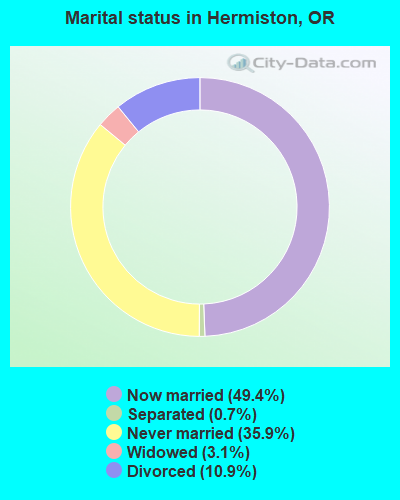
- Never married: 35.9%
- Now married: 49.4%
- Separated: 0.7%
- Widowed: 3.1%
- Divorced: 10.9%
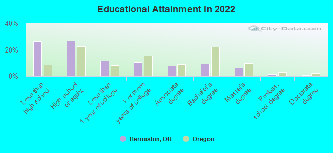
For population 25 years and over in Hermiston:
- High school or higher: 74.2%
- Bachelor's degree or higher: 16.5%
- Graduate or professional degree: 6.9%
- Unemployed: 7.7%
- Mean travel time to work (commute): 21.6 minutes
| Here: | 20.6 |
| Oregon average: | 11.6 |


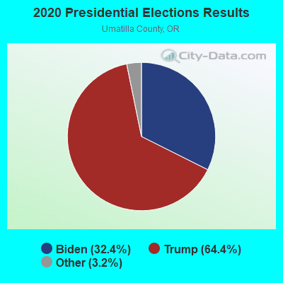
Graphs represent county-level data. Detailed 2008 Election Results
Religion statistics for Hermiston, OR (based on Umatilla County data)
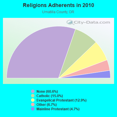
| Religion | Adherents | Congregations |
|---|---|---|
| Catholic | 11,402 | 6 |
| Evangelical Protestant | 9,816 | 75 |
| Other | 5,107 | 17 |
| Mainline Protestant | 3,575 | 24 |
| None | 45,989 | - |
Food Environment Statistics:
| This county: | 2.18 / 10,000 pop. |
| State: | 2.03 / 10,000 pop. |
| Here: | 0.55 / 10,000 pop. |
| Oregon: | 0.33 / 10,000 pop. |
| Here: | 1.78 / 10,000 pop. |
| Oregon: | 2.01 / 10,000 pop. |
| This county: | 1.91 / 10,000 pop. |
| State: | 1.69 / 10,000 pop. |
| Umatilla County: | 7.92 / 10,000 pop. |
| Oregon: | 9.93 / 10,000 pop. |
| Umatilla County: | 7.8% |
| State: | 7.4% |
| This county: | 32.4% |
| State: | 25.6% |
| Umatilla County: | 16.9% |
| Oregon: | 14.2% |
Health and Nutrition:
| Hermiston: | 47.2% |
| Oregon: | 49.6% |
| Hermiston: | 44.2% |
| Oregon: | 46.8% |
| This city: | 28.3 |
| Oregon: | 28.5 |
| Here: | 22.8% |
| State: | 21.2% |
| Hermiston: | 10.2% |
| Oregon: | 10.1% |
| Hermiston: | 6.8 |
| Oregon: | 6.8 |
| Here: | 31.7% |
| Oregon: | 33.3% |
| Hermiston: | 54.4% |
| Oregon: | 56.5% |
| Hermiston: | 78.8% |
| State: | 78.7% |
More about Health and Nutrition of Hermiston, OR Residents
| Local government employment and payroll (March 2022) | |||||
| Function | Full-time employees | Monthly full-time payroll | Average yearly full-time wage | Part-time employees | Monthly part-time payroll |
|---|---|---|---|---|---|
| Police Protection - Officers | 28 | $215,796 | $92,484 | 0 | $0 |
| Sewerage | 10 | $59,500 | $71,400 | 0 | $0 |
| Water Supply | 9 | $59,876 | $79,835 | 0 | $0 |
| Parks and Recreation | 8 | $46,268 | $69,402 | 16 | $14,848 |
| Other Government Administration | 6 | $52,664 | $105,328 | 9 | $1,050 |
| Financial Administration | 5 | $32,916 | $78,998 | 0 | $0 |
| Other and Unallocable | 4 | $35,122 | $105,366 | 1 | $4,234 |
| Local Libraries | 4 | $24,868 | $74,604 | 7 | $20,428 |
| Streets and Highways | 4 | $25,078 | $75,234 | 0 | $0 |
| Judicial and Legal | 4 | $28,260 | $84,780 | 1 | $2,728 |
| Police - Other | 4 | $21,824 | $65,472 | 0 | $0 |
| Solid Waste Management | 1 | $5,892 | $70,704 | 0 | $0 |
| Totals for Government | 87 | $608,064 | $83,871 | 34 | $43,288 |
Hermiston government finances - Expenditure in 2021 (per resident):
- Construction - Libraries: $907,000 ($46.70)
Water Utilities: $518,000 ($26.67)
Electric Utilities: $496,000 ($25.54)
Sewerage: $229,000 ($11.79)
Air Transportation: $170,000 ($8.75)
Regular Highways: $20,000 ($1.03)
Police Protection: $9,000 ($0.46)
- Current Operations - Electric Utilities: $7,420,000 ($382.02)
Police Protection: $5,330,000 ($274.42)
Water Utilities: $2,336,000 ($120.27)
Sewerage: $2,142,000 ($110.28)
General - Other: $2,027,000 ($104.36)
Parks and Recreation: $1,691,000 ($87.06)
Central Staff Services: $1,128,000 ($58.08)
Regular Highways: $1,008,000 ($51.90)
Libraries: $846,000 ($43.56)
Financial Administration: $570,000 ($29.35)
Judicial and Legal Services: $501,000 ($25.79)
Protective Inspection and Regulation - Other: $442,000 ($22.76)
Air Transportation: $329,000 ($16.94)
General Public Buildings: $133,000 ($6.85)
- Electric Utilities - Interest on Debt: $444,000 ($22.86)
- General - Interest on Debt: $267,000 ($13.75)
- Other Capital Outlay - Water Utilities: $171,000 ($8.80)
Police Protection: $19,000 ($0.98)
- Total Salaries and Wages: $11,967,000 ($616.13)
- Water Utilities - Interest on Debt: $841,000 ($43.30)
Hermiston government finances - Revenue in 2021 (per resident):
- Charges - Sewerage: $3,293,000 ($169.54)
Solid Waste Management: $395,000 ($20.34)
Air Transportation: $220,000 ($11.33)
Other: $173,000 ($8.91)
Parks and Recreation: $12,000 ($0.62)
- Local Intergovernmental - General Local Government Support: $445,000 ($22.91)
Other: $140,000 ($7.21)
- Miscellaneous - Donations From Private Sources: $330,000 ($16.99)
Fines and Forfeits: $294,000 ($15.14)
General Revenue - Other: $45,000 ($2.32)
Interest Earnings: $26,000 ($1.34)
Special Assessments: $6,000 ($0.31)
- Revenue - Water Utilities: $4,529,000 ($233.18)
- State Intergovernmental - Highways: $1,675,000 ($86.24)
Other: $819,000 ($42.17)
General Local Government Support: $649,000 ($33.41)
Public Welfare: $11,000 ($0.57)
- Tax - Property: $6,784,000 ($349.28)
Public Utilities Sales: $1,593,000 ($82.02)
Other License: $1,011,000 ($52.05)
Other Selective Sales: $771,000 ($39.70)
Alcoholic Beverage License: $1,000 ($0.05)
Hermiston government finances - Debt in 2021 (per resident):
- Long Term Debt - Outstanding Unspecified Public Purpose: $60,969,000 ($3139.01)
Beginning Outstanding - Unspecified Public Purpose: $53,487,000 ($2753.80)
Issue, Unspecified Public Purpose: $23,695,000 ($1219.95)
Retired Unspecified Public Purpose: $16,213,000 ($834.73)
Hermiston government finances - Cash and Securities in 2021 (per resident):
- Bond Funds - Cash and Securities: $7,402,000 ($381.09)
- Other Funds - Cash and Securities: $19,649,000 ($1011.64)
| Businesses in Hermiston, OR | ||||
| Name | Count | Name | Count | |
|---|---|---|---|---|
| 7-Eleven | 1 | Maurices | 1 | |
| Ace Hardware | 1 | McDonald's | 1 | |
| AutoZone | 1 | Motel 6 | 1 | |
| Best Western | 1 | Nike | 2 | |
| Burger King | 1 | OfficeMax | 1 | |
| Chevrolet | 1 | Payless | 1 | |
| Circle K | 2 | Pizza Hut | 1 | |
| Comfort Inn | 1 | Quiznos | 1 | |
| Dairy Queen | 1 | Rite Aid | 1 | |
| Dennys | 1 | Rue21 | 1 | |
| Domino's Pizza | 1 | Sears | 1 | |
| FedEx | 7 | Sprint Nextel | 1 | |
| Ford | 1 | Starbucks | 2 | |
| GNC | 1 | Subaru | 1 | |
| Goodwill | 1 | Taco Bell | 1 | |
| H&R Block | 1 | Toyota | 1 | |
| Home Depot | 1 | U-Haul | 1 | |
| Jack In The Box | 1 | U.S. Cellular | 2 | |
| KFC | 1 | UPS | 5 | |
| La-Z-Boy | 1 | Vans | 1 | |
| Lane Furniture | 1 | Verizon Wireless | 2 | |
| Little Caesars Pizza | 1 | Vons | 1 | |
| MasterBrand Cabinets | 6 | Walmart | 1 | |
Strongest AM radio stations in Hermiston:
- KOHU (1360 AM; 4 kW; HERMISTON, OR; Owner: WESTEND RADIO, LLC)
- KLWJ (1090 AM; daytime; 2 kW; UMATILLA, OR; Owner: UMATILLA BROADCASTING, INC.)
- KFLD (870 AM; 10 kW; PASCO, WA; Owner: CAPSTAR TX LIMITED PARTNERSHIP)
- KONA (610 AM; 5 kW; KENNEWICK-RICHLAND-P, WA; Owner: COMMONWEALTH LICENSE SUBSIDIARY, LLC)
- KALE (960 AM; 5 kW; RICHLAND, WA; Owner: NEW NORTHWEST BROADCASTERS, LLC)
- KTBI (810 AM; daytime; 50 kW; EPHRATA, WA; Owner: TACOMA BROADCASTERS, INCORPORATED)
- KUMA (1290 AM; 5 kW; PENDLETON, OR; Owner: ROUND-UP RADIO, INC.)
- KZTS (1210 AM; 10 kW; SUNNYSIDE, WA; Owner: BUTTERFIELD BROADCASTING CORPORATION)
- KPOJ (620 AM; 50 kW; PORTLAND, OR; Owner: CITICASTERS LICENSES, L.P.)
- KZXR (1310 AM; 5 kW; PROSSER, WA; Owner: MOON BROADCASTING PROSSER LLC)
- KXL (750 AM; 50 kW; PORTLAND, OR; Owner: ROSE CITY RADIO CORPORATION)
- KPAM (860 AM; 50 kW; TROUTDALE, OR; Owner: PAMPLIN BROADCASTING-OREGON, INC.)
- KIRO (710 AM; 50 kW; SEATTLE, WA; Owner: ENTERCOM SEATTLE LICENSE, LLC)
Strongest FM radio stations in Hermiston:
- KQFM (100.5 FM; HERMISTON, OR; Owner: WESTEND RADIO, LLC)
- KONA-FM (105.3 FM; KENNEWICK, WA; Owner: COMMONWEALTH LICENSE SUBSIDIARY, LLC)
- KFAE-FM (89.1 FM; RICHLAND, WA; Owner: WASHINGTON STATE UNIVERSITY)
- KORD-FM (102.7 FM; RICHLAND, WA; Owner: CAPSTAR TX LIMITED PARTNERSHIP)
- KEYW (98.3 FM; PASCO, WA; Owner: CAPSTAR TX LIMITED PARTNERSHIP)
- KEGX (106.5 FM; RICHLAND, WA; Owner: NEW NORTHWEST BROADCASTERS, LLC)
- KOLU (90.1 FM; PASCO, WA; Owner: RIVERVIEW BAPTIST CHRISTIAN SCHOOLS)
- KBLD (91.7 FM; KENNEWICK, WA; Owner: CSN INTERNATIONAL)
- KGDN (101.3 FM; PASCO, WA; Owner: WEST PASCO FINE ARTS RADIO)
- KGSG (93.7 FM; PASCO, WA; Owner: GOSPEL MUSIC BROADCASTING CORP.)
- K261CG (100.1 FM; PASCO, WA; Owner: NORTHWEST CHICANO RADIO NETWORK)
- K204CZ (88.7 FM; KENNEWICK, WA; Owner: CALVARY CHAPEL OF TWIN FALLS, INC.)
- KXRX (97.1 FM; WALLA WALLA, WA; Owner: CAPSTAR TX LIMITED PARTNERSHIP)
- KIOK (94.9 FM; RICHLAND, WA; Owner: NEW NORTHWEST BROADCASTERS, LLC)
- KOLW (97.9 FM; MILTON-FREEWATER, OR; Owner: CAPSTAR TX LIMITED PARTNERSHIP)
- KUJ-FM (99.1 FM; WALLA WALLA, WA; Owner: ALEXANDRA COMMUNICATIONS)
- K204DH (88.7 FM; HANFORD, WA; Owner: CALVARY CHAPEL OF TWIN FALLS, INC.)
- KRBM (90.9 FM; PENDLETON, OR; Owner: OREGON PUBLIC BROADCASTING)
- KLES (98.7 FM; MABTON, WA; Owner: ON-AIR FAMILY, LLC)
- KRKL (93.3 FM; WALLA WALLA, WA; Owner: EDUCATIONAL MEDIA FOUNDATION)
TV broadcast stations around Hermiston:
- KEPR-TV (Channel 19; PASCO, WA; Owner: FISHER BROADCASTING - WASHINGTON TV, L.L.C.)
- KNDU (Channel 25; RICHLAND, WA; Owner: KHQ, INCORPORATED)
- National Bridge Inventory (NBI) Statistics
- 39Number of bridges
- 312ft / 94.7mTotal length
- $1,137,000Total costs
- 189,189Total average daily traffic
- 53,887Total average daily truck traffic
- New bridges - historical statistics
- 11930-1939
- 11940-1949
- 11950-1959
- 171960-1969
- 41970-1979
- 81980-1989
- 31990-1999
- 22000-2009
- 22010-2019
FCC Registered Antenna Towers: 81 (See the full list of FCC Registered Antenna Towers)
FCC Registered Private Land Mobile Towers: 2 (See the full list of FCC Registered Private Land Mobile Towers in Hermiston, OR)
FCC Registered Broadcast Land Mobile Towers: 48 (See the full list of FCC Registered Broadcast Land Mobile Towers)
FCC Registered Microwave Towers: 42 (See the full list of FCC Registered Microwave Towers in this town)
FCC Registered Paging Towers: 1 (See the full list of FCC Registered Paging Towers)
FCC Registered Maritime Coast & Aviation Ground Towers: 1 (See the full list of FCC Registered Maritime Coast & Aviation Ground Towers)
FCC Registered Amateur Radio Licenses: 165 (See the full list of FCC Registered Amateur Radio Licenses in Hermiston)
FAA Registered Aircraft: 57 (See the full list of FAA Registered Aircraft in Hermiston)
2002 - 2018 National Fire Incident Reporting System (NFIRS) incidents
- Fire incident types reported to NFIRS in Hermiston, OR
- 94954.0%Outside Fires
- 46326.3%Structure Fires
- 31618.0%Mobile Property/Vehicle Fires
- 301.7%Other
 Based on the data from the years 2002 - 2018 the average number of fire incidents per year is 103. The highest number of reported fires - 179 took place in 2004, and the least - 2 in 2017. The data has a dropping trend.
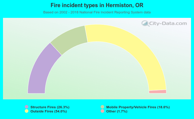 When looking into fire subcategories, the most reports belonged to: Outside Fires (54.0%), and Structure Fires (26.3%).
Fire-safe hotels and motels in Hermiston, Oregon:
- Best Western Hermiston Inn, 2255 Hwy 395 S, Hermiston, Oregon 97838 , Phone: (541) 564-0202, Fax: (541) 567-5512
- Comfort Inn & Suites, I-84 & Hwy 207, Hermiston, Oregon 97838 , Phone: (541) 564-5911, Fax: (541) 567-0434
- Rodeway Inn & Suites, 635 S Hwy 395, Hermiston, Oregon 97838 , Phone: (541) 567-5561, Fax: (541) 289-8767
- Holiday Inn Express & Suites Downtown Hermiston, 245 N 1st St Hermiston OR 97838, Hermiston, Oregon 97838 , Phone: (541) 585-5656, Fax: (541) 585-1212
- Hermiston Comfort Inn & Suites, 77514 S Hwy 207, Hermiston, Oregon 97838 , Phone: (541) 564-5911, Fax: (541) 567-0434
- Comfort Inn & Suites Hermiston, 77514 South Hwy 207, Hermiston, Oregon 97838 , Phone: (541) 564-5911
| Most common first names in Hermiston, OR among deceased individuals | ||
| Name | Count | Lived (average) |
|---|---|---|
| John | 103 | 75.7 years |
| William | 80 | 75.5 years |
| Mary | 75 | 80.8 years |
| James | 65 | 72.8 years |
| Robert | 61 | 73.3 years |
| George | 53 | 75.9 years |
| Charles | 53 | 77.2 years |
| Harold | 41 | 73.9 years |
| Helen | 37 | 80.5 years |
| Donald | 37 | 73.7 years |
| Most common last names in Hermiston, OR among deceased individuals | ||
| Last name | Count | Lived (average) |
|---|---|---|
| Johnson | 38 | 80.3 years |
| Smith | 36 | 78.4 years |
| Brown | 30 | 77.6 years |
| Thompson | 25 | 76.7 years |
| Clark | 22 | 70.9 years |
| Davis | 22 | 71.4 years |
| Jones | 19 | 75.6 years |
| Miller | 19 | 76.2 years |
| Rogers | 19 | 77.5 years |
| Jackson | 18 | 75.1 years |
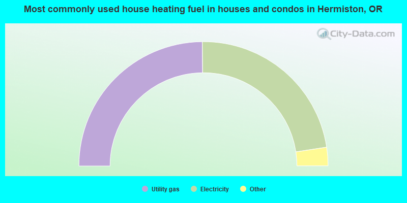
- 49.7%Utility gas
- 45.5%Electricity
- 3.2%Wood
- 1.3%Bottled, tank, or LP gas
- 0.2%No fuel used
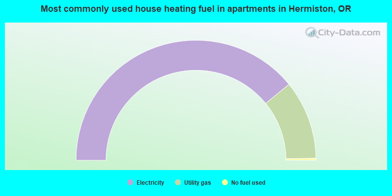
- 78.3%Electricity
- 21.3%Utility gas
- 0.5%No fuel used
Hermiston compared to Oregon state average:
- Median house value below state average.
- Unemployed percentage below state average.
- Hispanic race population percentage significantly above state average.
- Median age below state average.
- Foreign-born population percentage significantly above state average.
- Length of stay since moving in significantly above state average.
- Percentage of population with a bachelor's degree or higher below state average.

|
|
Total of 17 patent applications in 2008-2024.