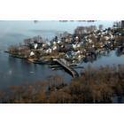
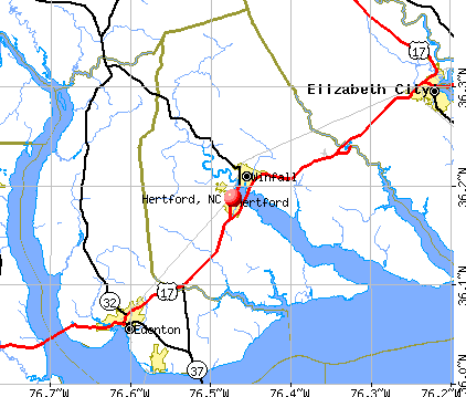
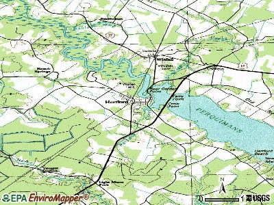
Hertford, North Carolina
Hertford: The S Bridge
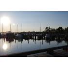
Hertford: Sunset in Alberlmarle Sound, Hertford, NC
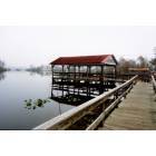
Hertford: Missing Mill Park
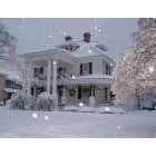
Hertford: Nixon House at Christmas - Hertford, North Carolina
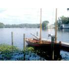
Hertford: The Periauger at City Docks
- add
your
Submit your own pictures of this town and show them to the world
- OSM Map
- General Map
- Google Map
- MSN Map
Population change since 2000: -5.3%
 |
| Males: 827 | |
| Females: 1,133 |
| Median resident age: | 43.1 years |
| North Carolina median age: | 39.2 years |
Zip codes: 27944.
| Hertford: | $44,551 |
| NC: | $67,481 |
Estimated per capita income in 2022: $27,928 (it was $13,502 in 2000)
Hertford town income, earnings, and wages data
Estimated median house or condo value in 2022: $220,036 (it was $66,100 in 2000)
| Hertford: | $220,036 |
| NC: | $280,600 |
Median gross rent in 2022: $709.
(10.2% for White Non-Hispanic residents, 33.5% for Black residents, 34.5% for two or more races residents)
Detailed information about poverty and poor residents in Hertford, NC

Compare current foreclosures near Hertford, NC:
| Photo | Address | Area | Beds / Baths | Price | Details |
|---|---|---|---|---|---|

|
#1
Chapanoke Rd
Hertford, NC 27944
|
1,728 sq. feet
|
2 baths 3 beds |
show details | |

|
#2
Dobbs St
Hertford, NC 27944
|
- sq. feet
|
1 baths 3 beds |
show details | |

|
#3
E Inlet Cir
Hertford, NC 27944
|
1,753 sq. feet
|
- baths 3 beds |
show details | |

|
#4
Chapanoke Rd
Hertford, NC 27944
|
- sq. feet
|
- baths - beds |
show details | |

|
#5
Big Flatty Creek Ct
Hertford, NC 27944
|
- sq. feet
|
- baths - beds |
show details | |

|
#6
Mill Rd
Hertford, NC 27944
|
- sq. feet
|
- baths - beds |
show details | |

|
#7
Castleton Dr
Hertford, NC 27944
|
- sq. feet
|
- baths - beds |
show details | |

|
#8
Big Flatty Creek Ct
Hertford, NC 27944
|
- sq. feet
|
- baths - beds |
show details | |

|
#9
Suttons Landing Rd
Hertford, NC 27944
|
- sq. feet
|
- baths - beds |
show details | |

|
#10
Winfall Blvd
Hertford, NC 27944
|
- sq. feet
|
- baths - beds |
show details |
| Photo | Address | Area | Beds / Baths | Price | Details |
|---|---|---|---|---|---|

|
#11
Fir St
Hertford, NC 27944
|
- sq. feet
|
- baths - beds |
show details | |

|
#12
Willow Dr
Edenton, NC 27932
|
- sq. feet
|
2 baths 3 beds |
$205,000
|
show details |

|
#13
Lisas Way
Elizabeth City, NC 27909
|
2,052 sq. feet
|
2 baths 4 beds |
show details | |

|
#14
Golfclub Dr
Elizabeth City, NC 27909
|
2,264 sq. feet
|
2 baths 3 beds |
show details | |

|
#15
Mohave Trl
Edenton, NC 27932
|
1,946 sq. feet
|
2 baths 3 beds |
show details | |

|
#16
Crystal Lake Dr
Elizabeth City, NC 27909
|
1,769 sq. feet
|
2 baths 3 beds |
show details | |

|
#17
Wildcat Rd
Edenton, NC 27932
|
1,248 sq. feet
|
2 baths 4 beds |
show details | |

|
#18
Dogwood Dr
Edenton, NC 27932
|
840 sq. feet
|
2 baths 3 beds |
show details | |

|
#19
Wingfield Rd
Tyner, NC 27980
|
1,782 sq. feet
|
2 baths 3 beds |
show details | |

|
#20
Mexico Rd
Edenton, NC 27932
|
1,392 sq. feet
|
1 baths 3 beds |
show details |
| Photo | Address | Area | Beds / Baths | Price | Details |
|---|---|---|---|---|---|

|
#21
Cypress Dr
Edenton, NC 27932
|
1,593 sq. feet
|
2 baths 3 beds |
show details | |

|
#22
Cannons Ferry Rd
Tyner, NC 27980
|
792 sq. feet
|
1 baths 4 beds |
show details | |

|
#23
Dillards Mill Rd
Tyner, NC 27980
|
2,176 sq. feet
|
2 baths 3 beds |
show details | |

|
#24
Green Rd
Tyner, NC 27980
|
1,008 sq. feet
|
1 baths 3 beds |
show details | |

|
#25
Swains Mill Rd
Harrellsville, NC 27942
|
1,512 sq. feet
|
2 baths 3 beds |
show details | |

|
#26
Sandy Ridge Rd
Edenton, NC 27932
|
960 sq. feet
|
1 baths 3 beds |
show details | |

|
#27
Morris Cir
Edenton, NC 27932
|
822 sq. feet
|
1 baths 2 beds |
show details | |

|
#28
Badham Rd
Edenton, NC 27932
|
1,425 sq. feet
|
1 baths 3 beds |
show details | |

|
#29
Nc Highway 45 N
Colerain, NC 27924
|
2,219 sq. feet
|
1 baths 4 beds |
show details | |

|
#30
Horseshoe Rd
Elizabeth City, NC 27909
|
- sq. feet
|
1 baths 3 beds |
show details |
| Photo | Address | Area | Beds / Baths | Price | Details |
|---|---|---|---|---|---|

|
#31
Valentine Ave
Edenton, NC 27932
|
1,053 sq. feet
|
1 baths 3 beds |
show details | |

|
#32
Halls Creek Rd
Elizabeth City, NC 27909
|
3,104 sq. feet
|
- baths 3 beds |
show details | |

|
#33
Emerald Lake Cir # 103
Elizabeth City, NC 27909
|
- sq. feet
|
- baths - beds |
show details | |

|
#34
Roscoe Dr
Elizabeth City, NC 27909
|
- sq. feet
|
- baths - beds |
show details | |

|
#35
Mosley St
Elizabeth City, NC 27909
|
- sq. feet
|
- baths - beds |
show details | |

|
#36
Walker Ave Apt 95
Elizabeth City, NC 27909
|
- sq. feet
|
- baths - beds |
show details | |

|
#37
Sandy Ter
Edenton, NC 27932
|
- sq. feet
|
- baths - beds |
show details | |

|
#38
Millbrooke Cir
Elizabeth City, NC 27909
|
- sq. feet
|
- baths - beds |
show details | |

|
#39
Aydlett Dr
Elizabeth City, NC 27909
|
- sq. feet
|
- baths - beds |
show details | |

|
#40
Forrest Skipper Dr
Elizabeth City, NC 27909
|
- sq. feet
|
- baths - beds |
show details |
| Photo | Address | Area | Beds / Baths | Price | Details |
|---|---|---|---|---|---|

|
#41
Cedar St
Elizabeth City, NC 27909
|
- sq. feet
|
- baths - beds |
show details | |

|
#42
Copeland Dr
Elizabeth City, NC 27909
|
- sq. feet
|
- baths - beds |
show details | |

|
#43
Cameron Dr Apt 101
Elizabeth City, NC 27909
|
- sq. feet
|
- baths - beds |
show details | |

|
#44
Comanche Trl
Edenton, NC 27932
|
- sq. feet
|
- baths - beds |
show details | |

|
#45
Union St
Elizabeth City, NC 27909
|
- sq. feet
|
- baths - beds |
show details | |

|
#46
Mohave Trl
Edenton, NC 27932
|
- sq. feet
|
- baths - beds |
show details | |

|
#47
Zack Cir
Elizabeth City, NC 27909
|
- sq. feet
|
- baths - beds |
show details | |

|
#48
Okisko Rd
Elizabeth City, NC 27909
|
- sq. feet
|
- baths - beds |
show details | |

|
#49
Foreman Bundy Rd
Elizabeth City, NC 27909
|
- sq. feet
|
- baths - beds |
show details | |

|
Check over 1 million property listings on Foreclosure.com!
|
browse all offers | |||


- 99747.7%Black alone
- 96546.2%White alone
- 673.2%Hispanic
- 261.2%Two or more races
- 10.05%Asian alone
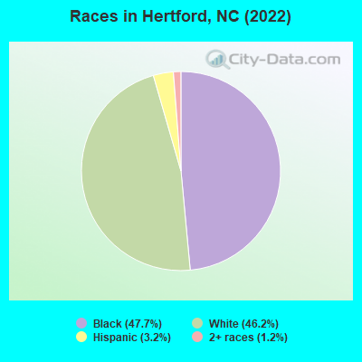
Races in Hertford detailed stats: ancestries, foreign born residents, place of birth
According to our research of North Carolina and other state lists, there were 36 registered sex offenders living in Hertford, North Carolina as of May 17, 2024.
The ratio of all residents to sex offenders in Hertford is 67 to 1.
 Recent articles from our blog. Our writers, many of them Ph.D. graduates or candidates, create easy-to-read articles on a wide variety of topics.

 | Old or Historic Homes in Hertford town, not county (1 reply) |
| Eastern NC Coronavirus Thread (259 replies) |
| Hertford NC (3 replies) |
| Road Construction/Projects in Coastal NC (429 replies) |
| Proposed I-795 Quad East loop (719 replies) |
| Retirement Options - advice needed (22 replies) |
Latest news from Hertford, NC collected exclusively by city-data.com from local newspapers, TV, and radio stations
Hertford, NC City Guides:
Ancestries: English (18.8%), American (7.1%), Irish (7.1%), German (4.6%), Italian (2.3%), European (1.9%).
Current Local Time: EST time zone
Elevation: 13 feet
Land area: 2.69 square miles.
Population density: 728 people per square mile (low).
14 residents are foreign born
| This town: | 0.7% |
| North Carolina: | 8.3% |
Median real estate property taxes paid for housing units with mortgages in 2022: $1,387 (0.6%)
Median real estate property taxes paid for housing units with no mortgage in 2022: $1,080 (0.5%)
Nearest city with pop. 50,000+: Suffolk, VA  (39.1 miles , pop. 63,677).
Nearest city with pop. 200,000+: Virginia Beach, VA (49.6 miles , pop. 425,257).
Nearest city with pop. 1,000,000+: Philadelphia, PA (273.3 miles , pop. 1,517,550).
Nearest cities:
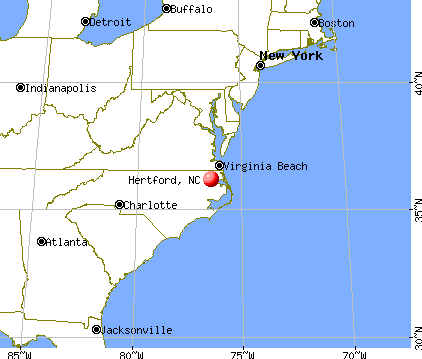
), ), ), ), )Latitude: 36.19 N, Longitude: 76.47 W
Area code: 252
| Here: | 3.8% |
| North Carolina: | 3.2% |
- Accommodation & food services (15.3%)
- Health care (12.9%)
- Educational services (11.4%)
- Construction (9.3%)
- Public administration (7.8%)
- Transportation equipment (5.2%)
- Agriculture, forestry, fishing & hunting (3.0%)
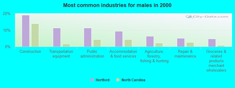
- Construction (19.0%)
- Transportation equipment (11.3%)
- Public administration (11.3%)
- Accommodation & food services (9.4%)
- Agriculture, forestry, fishing & hunting (6.5%)
- Repair & maintenance (5.2%)
- Groceries & related products merchant wholesalers (4.8%)
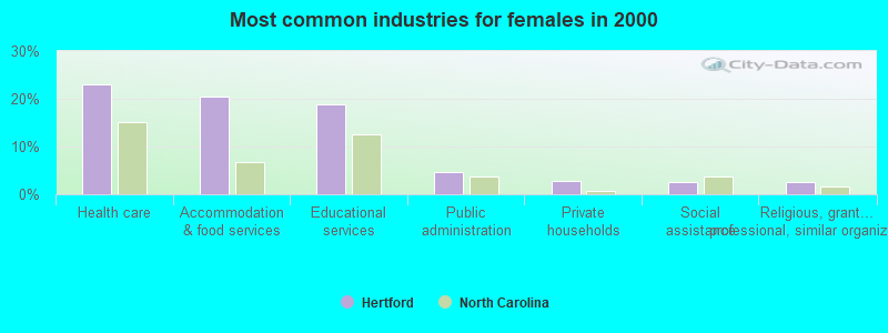
- Health care (23.0%)
- Accommodation & food services (20.4%)
- Educational services (18.8%)
- Public administration (4.8%)
- Private households (2.8%)
- Social assistance (2.5%)
- Religious, grantmaking, civic, professional, similar organizations (2.5%)
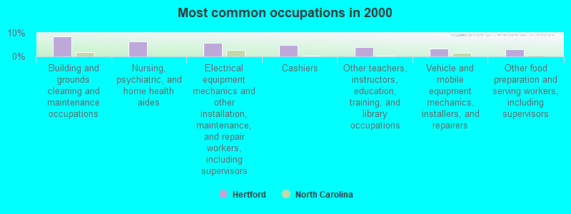
- Building and grounds cleaning and maintenance occupations (8.5%)
- Nursing, psychiatric, and home health aides (6.4%)
- Electrical equipment mechanics and other installation, maintenance, and repair workers, including supervisors (5.7%)
- Cashiers (4.9%)
- Other teachers, instructors, education, training, and library occupations (3.9%)
- Vehicle and mobile equipment mechanics, installers, and repairers (3.4%)
- Other food preparation and serving workers, including supervisors (3.1%)
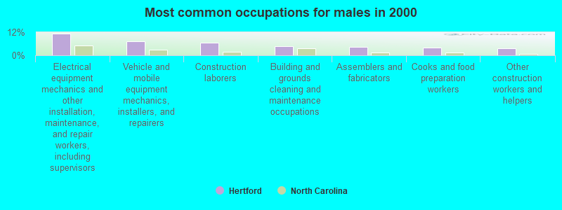
- Electrical equipment mechanics and other installation, maintenance, and repair workers, including supervisors (11.3%)
- Vehicle and mobile equipment mechanics, installers, and repairers (7.4%)
- Construction laborers (6.5%)
- Building and grounds cleaning and maintenance occupations (4.8%)
- Assemblers and fabricators (4.2%)
- Cooks and food preparation workers (3.9%)
- Other construction workers and helpers (3.5%)
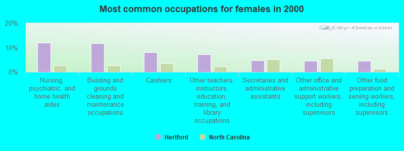
- Nursing, psychiatric, and home health aides (12.0%)
- Building and grounds cleaning and maintenance occupations (11.8%)
- Cashiers (8.1%)
- Other teachers, instructors, education, training, and library occupations (7.3%)
- Secretaries and administrative assistants (4.8%)
- Other office and administrative support workers, including supervisors (4.5%)
- Other food preparation and serving workers, including supervisors (4.5%)
Average climate in Hertford, North Carolina
Based on data reported by over 4,000 weather stations


|
|

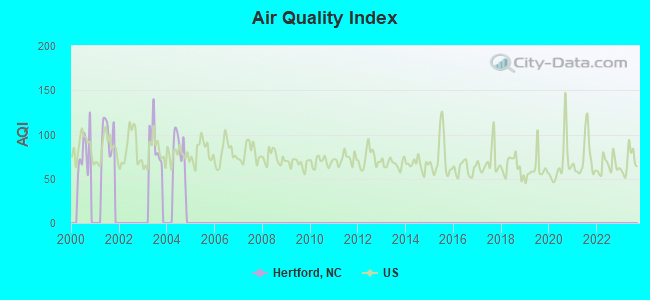
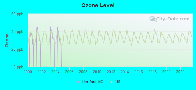
Tornado activity:
Hertford-area historical tornado activity is near North Carolina state average. It is 19% smaller than the overall U.S. average.
On 11/23/1992, a category F3 (max. wind speeds 158-206 mph) tornado 16.7 miles away from the Hertford town center injured 44 people and caused between $500,000 and $5,000,000 in damages.
On 3/28/1984, a category F3 tornado 17.9 miles away from the town center killed 2 people and injured 10 people and caused between $500,000 and $5,000,000 in damages.
Earthquake activity:
Hertford-area historical earthquake activity is significantly above North Carolina state average. It is 64% smaller than the overall U.S. average.On 8/23/2011 at 17:51:04, a magnitude 5.8 (5.8 MW, Depth: 3.7 mi, Class: Moderate, Intensity: VI - VII) earthquake occurred 144.0 miles away from the city center
On 12/9/2003 at 20:59:14, a magnitude 4.5 (4.5 MB, 4.5 LG, Class: Light, Intensity: IV - V) earthquake occurred 125.0 miles away from Hertford center
On 8/9/2020 at 12:07:37, a magnitude 5.1 (5.1 MW, Depth: 4.7 mi) earthquake occurred 258.2 miles away from the city center
On 12/9/2003 at 20:59:18, a magnitude 4.5 (4.5 ML, Depth: 6.2 mi) earthquake occurred 141.9 miles away from Hertford center
On 8/25/2011 at 05:07:52, a magnitude 4.5 (4.5 ML, Depth: 4.2 mi) earthquake occurred 147.0 miles away from the city center
On 1/15/2019 at 23:30:48, a magnitude 4.6 (4.6 MW, Depth: 6.2 mi) earthquake occurred 205.1 miles away from Hertford center
Magnitude types: regional Lg-wave magnitude (LG), body-wave magnitude (MB), local magnitude (ML), moment magnitude (MW)
Natural disasters:
The number of natural disasters in Perquimans County (16) is near the US average (15).Major Disasters (Presidential) Declared: 7
Emergencies Declared: 6
Causes of natural disasters: Hurricanes: 12, Storms: 2, Tornadoes: 2, Flood: 1, Ice Storm: 1, Other: 1 (Note: some incidents may be assigned to more than one category).
Hospitals and medical centers in Hertford:
Other hospitals and medical centers near Hertford:
- CHOWAN RIVER NURSING AND REHABILITATION CENTER (Nursing Home, about 11 miles away; EDENTON, NC)
- LIFE, INC COKE AVENUE GROUP HOME (Hospital, about 12 miles away; EDENTON, NC)
- VIDANT CHOWAN HOSPITAL Critical Access Hospitals (about 12 miles away; EDENTON, NC)
- EDENTON DIALYSIS (Dialysis Facility, about 12 miles away; EDENTON, NC)
- LIFE, INC LUKE STREET GROUP HOME (Hospital, about 12 miles away; EDENTON, NC)
- W R WINSLOW MEMORIAL HOME INC (Nursing Home, about 15 miles away; ELIZABETH CITY, NC)
- GUARDIAN CARE OF ELIZABETH CITY INC (Nursing Home, about 15 miles away; ELIZABETH CITY, NC)
Airports and heliports located in Hertford:
- Craft Airport (86NC) (Runways: 1)
- Harvey Point Defense Testing Activity Airport (NC01) (Runways: 1)
- Isbell Heliport (21NC)
Colleges/universities with over 2000 students nearest to Hertford:
- Elizabeth City State University (about 16 miles; Elizabeth City, NC; Full-time enrollment: 2,803)
- Regent University (about 46 miles; Virginia Beach, VA; FT enrollment: 3,429)
- Tidewater Community College (about 47 miles; Norfolk, VA; FT enrollment: 20,975)
- Norfolk State University (about 48 miles; Norfolk, VA; FT enrollment: 6,032)
- ECPI University (about 49 miles; Virginia Beach, VA; FT enrollment: 10,694)
- Old Dominion University (about 50 miles; Norfolk, VA; FT enrollment: 19,825)
- Hampton University (about 59 miles; Hampton, VA; FT enrollment: 4,494)
Public high school in Hertford:
- PERQUIMANS COUNTY HIGH (Location: 305 EDENTON ROAD ST, Grades: 9-12)
Public elementary/middle school in Hertford:
- HERTFORD GRAMMAR (Location: 603 DOBBS STREET, Grades: 3-5)
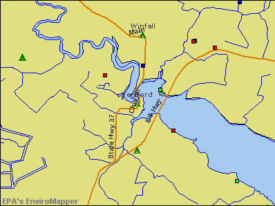
Points of interest:
Notable locations in Hertford: Hertford Wastewater Treatment Plant (A), Municipal Building (B), Perquimans County Courthouse (C), Newbold-White (D), Brian Center Health and Rehabilitation of Hertford (E), Hertford Police Department (F), Winfall Police Department (G). Display/hide their locations on the map
Shopping Center: Harris Shopping Center (1). Display/hide its location on the map
Churches in Hertford include: First Baptist Church of Hertford (A), Saint Pauls Church (B), Hertford United Methodist Church (C), Hertford Baptist Church (D), Church of the Holy Trinity (E), Holy Trinity Episcopal Church (F). Display/hide their locations on the map
Cemetery: Cedarwood Cemetery (1). Display/hide its location on the map
Birthplace of: Catfish Hunter - Baseball player, Beulah Burke - Educator, Lillie Burke - Educator.
| This town: | 2.4 people |
| North Carolina: | 2.5 people |
| This town: | 63.2% |
| Whole state: | 66.7% |
| This town: | 4.7% |
| Whole state: | 5.9% |
Likely homosexual households (counted as self-reported same-sex unmarried-partner households)
- Lesbian couples: 0.3% of all households
- Gay men: 0.0% of all households
64 people in nursing homes in 2000
Banks with branches in Hertford (2011 data):
- The East Carolina Bank: Hertford Branch at 1103 Harvey Point Road, branch established on 2000/10/02. Info updated 2010/05/27: Bank assets: $921.7 mil, Deposits: $797.6 mil, headquarters in Engelhard, NC, positive income, Commercial Lending Specialization, 25 total offices, Holding Company: Ecb Bancorp, Inc.
- Hertford Savings Bank, SSB: Hertford Savings Bank, Ssb at 121 North Church Street, branch established on 1923/01/01. Info updated 2006/11/03: Bank assets: $15.9 mil, Deposits: $14.0 mil, local headquarters, positive income, Mortgage Lending Specialization, 1 total offices
- PNC Bank, National Association: Hertford Branch at 106 North Church Street, branch established on 1960/02/23. Info updated 2012/03/20: Bank assets: $263,309.6 mil, Deposits: $197,343.0 mil, headquarters in Wilmington, DE, positive income, Commercial Lending Specialization, 3085 total offices, Holding Company: Pnc Financial Services Group, Inc., The
For population 15 years and over in Hertford:
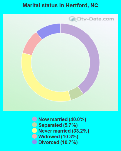
- Never married: 33.2%
- Now married: 40.0%
- Separated: 5.7%
- Widowed: 10.3%
- Divorced: 10.7%
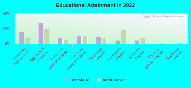
For population 25 years and over in Hertford:
- High school or higher: 79.6%
- Bachelor's degree or higher: 10.6%
- Graduate or professional degree: 5.4%
- Unemployed: 8.6%
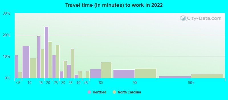
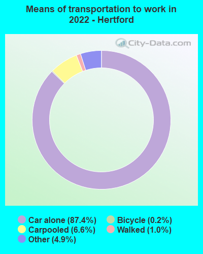
- Mean travel time to work (commute): 27.6 minutes
| Here: | 10.9 |
| North Carolina average: | 11.7 |
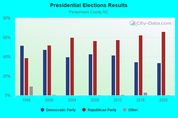
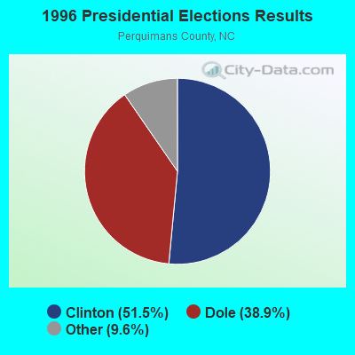
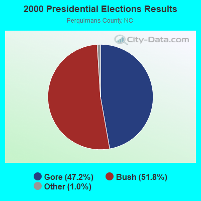
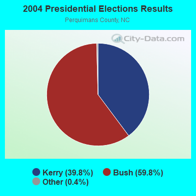
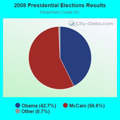
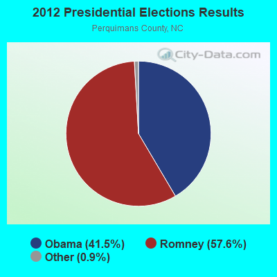
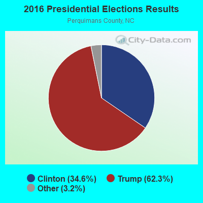
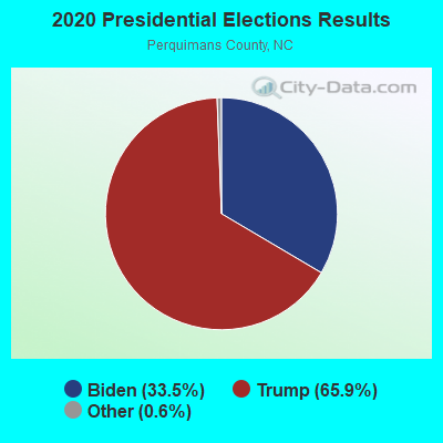
Graphs represent county-level data. Detailed 2008 Election Results
Religion statistics for Hertford, NC (based on Perquimans County data)
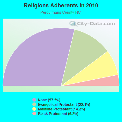
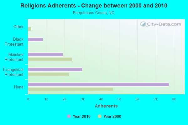
| Religion | Adherents | Congregations |
|---|---|---|
| Evangelical Protestant | 2,974 | 19 |
| Mainline Protestant | 1,911 | 12 |
| Black Protestant | 831 | 8 |
| Other | 2 | 1 |
| None | 7,735 | - |
Food Environment Statistics:
| Perquimans County: | 2.40 / 10,000 pop. |
| North Carolina: | 2.05 / 10,000 pop. |
| Perquimans County: | 3.20 / 10,000 pop. |
| State: | 0.92 / 10,000 pop. |
| Perquimans County: | 0.80 / 10,000 pop. |
| State: | 4.75 / 10,000 pop. |
| Perquimans County: | 6.40 / 10,000 pop. |
| State: | 7.57 / 10,000 pop. |
| Here: | 11.1% |
| North Carolina: | 9.8% |
| Perquimans County: | 31.4% |
| State: | 28.3% |
| Perquimans County: | 17.4% |
| North Carolina: | 15.6% |
Health and Nutrition:
| This city: | 49.1% |
| North Carolina: | 48.9% |
| Hertford: | 45.2% |
| North Carolina: | 46.1% |
| This city: | 29.6 |
| State: | 28.8 |
| This city: | 19.8% |
| North Carolina: | 20.7% |
| This city: | 12.7% |
| State: | 10.7% |
| This city: | 6.7 |
| North Carolina: | 6.8 |
| Here: | 36.9% |
| North Carolina: | 33.7% |
| Here: | 53.0% |
| North Carolina: | 55.8% |
| Hertford: | 78.6% |
| North Carolina: | 79.7% |
More about Health and Nutrition of Hertford, NC Residents
| Local government employment and payroll (March 2022) | |||||
| Function | Full-time employees | Monthly full-time payroll | Average yearly full-time wage | Part-time employees | Monthly part-time payroll |
|---|---|---|---|---|---|
| Other and Unallocable | 6 | $22,418 | $44,836 | 9 | $6,876 |
| Streets and Highways | 4 | $8,681 | $26,043 | 0 | $0 |
| Solid Waste Management | 3 | $11,695 | $46,780 | 0 | $0 |
| Electric Power | 1 | $3,621 | $43,452 | 0 | $0 |
| Water Supply | 1 | $2,959 | $35,508 | 0 | $0 |
| Other Government Administration | 0 | $0 | 7 | $1,968 | |
| Financial Administration | 0 | $0 | 1 | $650 | |
| Totals for Government | 15 | $49,374 | $39,499 | 17 | $9,494 |
Hertford government finances - Expenditure in 2017 (per resident):
- Current Operations - Electric Utilities: $2,710,000 ($1382.65)
Liquor Stores: $770,000 ($392.86)
Police Protection: $710,000 ($362.24)
Water Utilities: $622,000 ($317.35)
Regular Highways: $367,000 ($187.24)
Local Fire Protection: $308,000 ($157.14)
Financial Administration: $129,000 ($65.82)
Central Staff Services: $115,000 ($58.67)
Solid Waste Management: $113,000 ($57.65)
General - Other: $25,000 ($12.76)
Natural Resources - Other: $24,000 ($12.24)
Housing and Community Development: $19,000 ($9.69)
Health - Other: $3,000 ($1.53)
- Electric Utilities - Interest on Debt: $10,000 ($5.10)
- General - Interest on Debt: $17,000 ($8.67)
- Intergovernmental to Local - Other - Health - Other: $4,000 ($2.04)
- Total Salaries and Wages: $184,000 ($93.88)
- Water Utilities - Interest on Debt: $239,000 ($121.94)
Hertford government finances - Revenue in 2017 (per resident):
- Charges - Miscellaneous Commercial Activities: $179,000 ($91.33)
Solid Waste Management: $109,000 ($55.61)
- Miscellaneous - Interest Earnings: $0 ($0.00)
- Revenue - Electric Utilities: $2,999,000 ($1530.10)
Water Utilities: $1,306,000 ($666.33)
Liquor Stores: $857,000 ($437.24)
- State Intergovernmental - General Local Government Support: $667,000 ($340.31)
Other: $143,000 ($72.96)
Highways: $59,000 ($30.10)
- Tax - Property: $602,000 ($307.14)
Alcoholic Beverage Sales: $76,000 ($38.78)
Motor Vehicle License: $8,000 ($4.08)
Hertford government finances - Debt in 2017 (per resident):
- Long Term Debt - Beginning Outstanding - Unspecified Public Purpose: $8,293,000 ($4231.12)
Outstanding Unspecified Public Purpose: $7,927,000 ($4044.39)
Retired Unspecified Public Purpose: $366,000 ($186.73)
| Businesses in Hertford, NC | ||||
| Name | Count | Name | Count | |
|---|---|---|---|---|
| Ace Hardware | 1 | McDonald's | 1 | |
| Curves | 1 | Subway | 1 | |
| FedEx | 1 | U-Haul | 1 | |
| H&R Block | 1 | U.S. Cellular | 1 | |
| Hardee's | 1 | UPS | 2 | |
Strongest AM radio stations in Hertford:
- WCKO (1110 AM; daytime; 50 kW; NORFOLK, VA; Owner: WORD BROADCASTING NETWORK, INC.)
- WTAR (850 AM; 50 kW; NORFOLK, VA; Owner: SINCLAIR COMMUNICATIONS)
- WZBO (1260 AM; 1 kW; EDENTON, NC; Owner: LAWRENCE LOESCH & MARGARET LOESCH)
- WGAI (560 AM; 1 kW; ELIZABETH CITY, NC; Owner: MAX RADIO OF THE CAROLINAS LICENSES LLC)
- WRJR (670 AM; 20 kW; CLAREMONT, VA; Owner: CHESAPEAKE-PORTSMOUTH BROADCASTING CORPORATION)
- WGH (1310 AM; 20 kW; NEWPORT NEWS, VA; Owner: CHESAPEAKE BAY BROADCASTING, LLC)
- WPMH (1010 AM; 10 kW; PORTSMOUTH, VA; Owner: ABC, INC.)
- WRVA (1140 AM; 50 kW; RICHMOND, VA; Owner: CLEAR CHANNEL BROADCASTING LICENSES, INC.)
- WJPI (1470 AM; 5 kW; PLYMOUTH, NC; Owner: FREE TEMPLE MINISTRIES INC..)
- WPTF (680 AM; 50 kW; RALEIGH, NC; Owner: FIRST STATE COMMUNICATIONS)
- WHKT (1650 AM; 10 kW; PORTSMOUTH, VA; Owner: ABC, INC.)
- WCNC (1240 AM; 1 kW; ELIZABETH CITY, NC; Owner: EAST CAROLINA RADIO, INC.)
- WFTK (1030 AM; daytime; 50 kW; WAKE FOREST, NC; Owner: POSITIVE RADIO GROUP, INC.)
Strongest FM radio stations in Hertford:
- WFMZ (104.9 FM; HERTFORD, NC; Owner: MARANATHA BROADCASTING COMPANY, INC.)
- WKOC (93.7 FM; CHESAPEAKE, VA; Owner: COMMONWEALTH RADIO, L.L.C.)
- WGPS (88.3 FM; ELIZABETH CITY, NC; Owner: CSN INTERNATIONAL)
- WRSF (105.7 FM; COLUMBIA, NC; Owner: EAST CAROLINA RADIO, INC.)
- WERX-FM (102.5 FM; COLUMBIA, NC; Owner: LAWRENCE LOESCH & MARGARET LOESCH)
- WAFX (106.9 FM; SUFFOLK, VA; Owner: TIDEWATER COMMUNICATIONS, LLC)
- WCBZ (103.7 FM; WILLIAMSTON, NC; Owner: ABG NORTH CAROLINA, LLC)
- WCXL (104.1 FM; KILL DEVIL HILLS, NC; Owner: MAX RADIO OF THE CAROLINAS LICENSES LLC)
- WHRO-FM (90.3 FM; NORFOLK, VA; Owner: HAMPTON ROADS EDUCATIONAL TELECOMMUNICATIONS ASSOCIATION,INC)
- WHRV (89.5 FM; NORFOLK, VA; Owner: HAMPTON ROADS EDUCATIONAL TELECOMMUNICATIONS ASSOCIATION,INC)
- WBXB (100.1 FM; EDENTON, NC; Owner: EDENTON CHRISTIAN RADIO, INC.)
- WKJX (96.7 FM; ELIZABETH CITY, NC; Owner: EAST CAROLINA RADIO OF ELIZABETH CITY, INC.)
- WRVS-FM (89.9 FM; ELIZABETH CITY, NC; Owner: ELIZABETH CITY STATE UNIVERSITY)
- WQDK (99.3 FM; AHOSKIE, NC; Owner: MAX MEDIA OF THE CAROLINAS LLC)
TV broadcast stations around Hertford:
- WUND-TV (Channel 2; COLUMBIA, NC; Owner: UNIVERSITY OF NORTH CAROLINA)
- WTKR (Channel 3; NORFOLK, VA; Owner: NEW YORK TIMES MANAGEMENT SERVICES)
- WSKY-TV (Channel 4; MANTEO, NC; Owner: SKY TELEVISION, L.L.C.)
- WTVZ-TV (Channel 33; NORFOLK, VA; Owner: WTVZ LICENSEE, LLC)
- WHRO-TV (Channel 15; HAMPTON-NORFOLK, VA; Owner: HAMPTON ROADS EDUCATIONAL TELECOMMUNICATIONS ASSOC, INC.)
- WPXV (Channel 49; NORFOLK, VA; Owner: PAXSON COMMUNICATIONS LICENSE COMPANY, LLC)
- WVEC-TV (Channel 13; HAMPTON, VA; Owner: WVEC TELEVISION, INC.)
- WGNT (Channel 27; PORTSMOUTH, VA; Owner: UPN TELEVISION STATIONS INC.)
- WAVY-TV (Channel 10; PORTSMOUTH, VA; Owner: WAVY BROADCASTING, LLC)
- W18BB (Channel 18; ELIZABETH CITY, NC; Owner: ELIZABETH CITY STATE UNIVERSITY)
- National Bridge Inventory (NBI) Statistics
- 10Number of bridges
- 476ft / 145mTotal length
- 61,500Total average daily traffic
- 7,802Total average daily truck traffic
- 123,200Total future (year 2040) average daily traffic
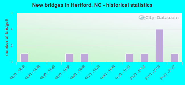
- New bridges - historical statistics
- 11920-1929
- 11950-1959
- 11960-1969
- 11990-1999
- 12000-2009
- 42010-2019
- 12020-2022
FCC Registered Cell Phone Towers:
1 (See the full list of FCC Registered Cell Phone Towers in Hertford)FCC Registered Antenna Towers:
40 (See the full list of FCC Registered Antenna Towers)FCC Registered Broadcast Land Mobile Towers:
15 (See the full list of FCC Registered Broadcast Land Mobile Towers in Hertford, NC)FCC Registered Microwave Towers:
4- STATION, 2 Mi N Cr 1300 Cr 1303 (Lat: 36.196250 Lon: -76.384639), Overall height: 129.5 m, Call Sign: WNTN304,
Assigned Frequencies: 952.831 MHz, 928.831 MHz, Grant Date: 03/12/2002, Expiration Date: 04/21/2012, Cancellation Date: 08/02/2011, Phone: (919) 872-0800
- HERTSFORD, 1 Nm W (Lat: 36.195278 Lon: -76.422500), Type: Gtower, Structure height: 121.9 m, Overall height: 126.5 m, Call Sign: WPSZ449,
Assigned Frequencies: 6315.84 MHz, Grant Date: 07/13/2021, Expiration Date: 08/13/2031, Certifier: Steven T Campbell, Registrant: Wilkinson Barker Knauer, LLP, 1800 M Street Nw, Suite 800n, Washington, DC 20036, Phone: (202) 383-3420, Fax: (202) 783-5851, Email:
- Hertford, NC, Lat: 36.233500 Lon: -76.172778, Call Sign: WQEN272,
Assigned Frequencies: 956.331 MHz, 956.331 MHz, 956.331 MHz, Grant Date: 02/17/2016, Expiration Date: 03/09/2026, Certifier: John Kuklinski, Registrant: Duke Energy Business Services, LLC, 401 South College Street, Charlotte, NC 28201, Phone: (704) 382-2271, Fax: (704) 382-4800, Email:
- PERQUIMANS COUNTY, Lat: 36.211944 Lon: -76.451389, Call Sign: WQFN584,
Assigned Frequencies: 956.443 MHz, Grant Date: 08/24/2006, Expiration Date: 08/24/2016, Cancellation Date: 10/29/2016, Certifier: Russ Chappell, Registrant: Amco Water Metering Systems Inc, 1100 Sw 38th Ave, Ocala, FL 34474, Phone: (352) 369-6500, Fax: (352) 369-6581, Email:
FCC Registered Maritime Coast & Aviation Ground Towers:
1- Albemarle Plantation (Lat: 36.083500 Lon: -76.416333), Type: Tower, Call Sign: WQB581,
Assigned Frequencies: 156.425 MHz, 156.450 MHz, 156.800 MHz, Grant Date: 03/15/2001, Expiration Date: 03/06/2011, Cancellation Date: 05/07/2011, Registrant: H P B Enterprises Inc, One Plantation Dr, Hertford, NC 27944
FCC Registered Amateur Radio Licenses:
88 (See the full list of FCC Registered Amateur Radio Licenses in Hertford)FAA Registered Aircraft Manufacturers and Dealers:
2 (See the full list of FAA Registered Manufacturers and Dealers in Hertford)FAA Registered Aircraft:
7 (See the full list of FAA Registered Aircraft)2002 - 2018 National Fire Incident Reporting System (NFIRS) incidents
- Fire incident types reported to NFIRS in Hertford, NC
- 34542.8%Structure Fires
- 29136.1%Outside Fires
- 9712.0%Mobile Property/Vehicle Fires
- 739.1%Other
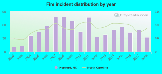 According to the data from the years 2002 - 2018 the average number of fires per year is 47. The highest number of reported fire incidents - 78 took place in 2007, and the least - 10 in 2002. The data has a rising trend.
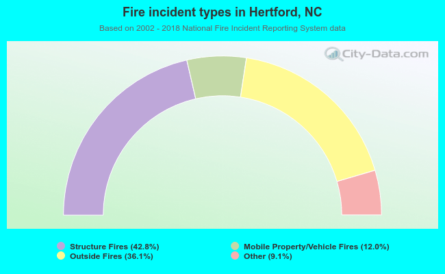 When looking into fire subcategories, the most reports belonged to: Structure Fires (42.8%), and Outside Fires (36.1%).
| Most common first names in Hertford, NC among deceased individuals | ||
| Name | Count | Lived (average) |
|---|---|---|
| William | 125 | 73.6 years |
| James | 94 | 70.9 years |
| Mary | 93 | 81.9 years |
| John | 91 | 73.7 years |
| George | 57 | 74.8 years |
| Robert | 37 | 70.9 years |
| Joseph | 35 | 75.9 years |
| Elizabeth | 35 | 81.3 years |
| Helen | 32 | 76.0 years |
| Charles | 32 | 72.7 years |
| Most common last names in Hertford, NC among deceased individuals | ||
| Last name | Count | Lived (average) |
|---|---|---|
| White | 109 | 76.2 years |
| Winslow | 55 | 77.5 years |
| Perry | 53 | 76.9 years |
| Lane | 46 | 81.7 years |
| Felton | 45 | 72.3 years |
| Harrell | 44 | 73.7 years |
| Jones | 40 | 77.2 years |
| Riddick | 37 | 74.4 years |
| Smith | 33 | 78.8 years |
| Stallings | 33 | 76.1 years |
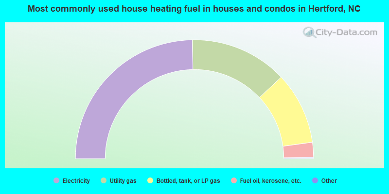
- 49.6%Electricity
- 26.6%Utility gas
- 19.7%Bottled, tank, or LP gas
- 4.1%Fuel oil, kerosene, etc.
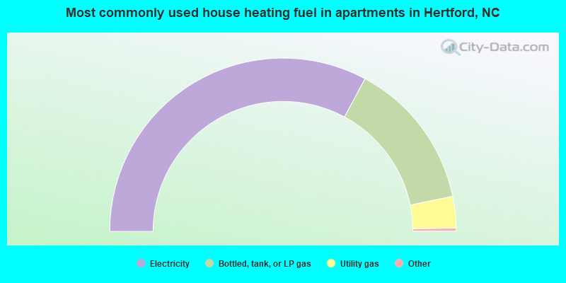
- 66.1%Electricity
- 28.0%Bottled, tank, or LP gas
- 5.9%Utility gas
Hertford compared to North Carolina state average:
- Median household income below state average.
- Black race population percentage above state average.
- Hispanic race population percentage significantly below state average.
- Median age below state average.
- Foreign-born population percentage significantly below state average.
- Renting percentage above state average.
- Length of stay since moving in below state average.
- House age above state average.
- Institutionalized population percentage above state average.
- Percentage of population with a bachelor's degree or higher significantly below state average.

|
|
Total of 11 patent applications in 2008-2024.