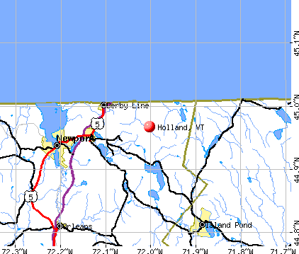
Holland, Vermont
Submit your own pictures of this town and show them to the world
- OSM Map
- General Map
- Google Map
- MSN Map
Population change since 2000: +7.0%
 |
| Males: 319 | |
| Females: 310 |
| Median resident age: | 42.6 years |
| Vermont median age: | 45.8 years |
Zip codes: 05830.
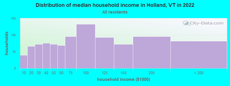
| Holland: | $58,354 |
| VT: | $73,991 |
Estimated per capita income in 2022: $25,173 (it was $11,936 in 2000)
Holland town income, earnings, and wages data
Estimated median house or condo value in 2022: $217,621 (it was $81,500 in 2000)
| Holland: | $217,621 |
| VT: | $304,700 |
Mean prices in 2022: all housing units: $271,502; detached houses: $290,446; townhouses or other attached units: $299,602; in 2-unit structures: $159,589; in 3-to-4-unit structures: $395,771; in 5-or-more-unit structures: $253,965; mobile homes: $74,912
Detailed information about poverty and poor residents in Holland, VT
Compare current foreclosures near Holland, VT:
| Photo | Address | Area | Beds / Baths | Price | Details |
|---|---|---|---|---|---|

|
#1
South St
Orleans, VT 05860
|
2,135 sq. feet
|
2 baths 3 beds |
$275,500
|
show details |

|
#2
Salem Derby Rd
Newport, VT 05855
|
- sq. feet
|
1 baths 3 beds |
$129,900
|
show details |

|
#3
Pepin Rd
Orleans, VT 05860
|
952 sq. feet
|
1 baths 1 beds |
show details | |

|
#4
Vt Route 14 N
Newport, VT 05855
|
- sq. feet
|
- baths - beds |
show details | |

|
#5
Vt Route 105
Newport Center, VT 05857
|
- sq. feet
|
- baths - beds |
show details | |

|
#6
Mount Vernon St
Newport, VT 05855
|
- sq. feet
|
- baths - beds |
show details | |

|
Check over 1 million property listings on Foreclosure.com!
|
browse all offers | |||

- 60996.8%White alone
- 61.0%Two or more races
- 50.8%Black alone
- 50.8%Hispanic
- 40.6%American Indian alone
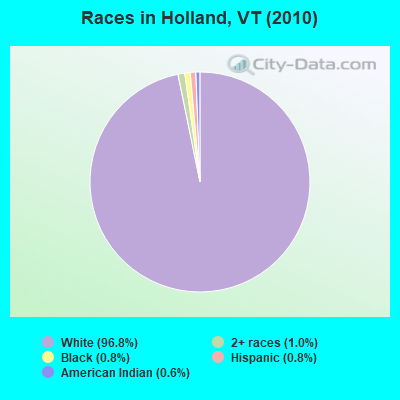
Races in Holland detailed stats: ancestries, foreign born residents, place of birth
According to our research of Vermont and other state lists, there were 2 registered sex offenders living in Holland, Vermont as of May 18, 2024.
The ratio of all residents to sex offenders in Holland is 315 to 1.
 Recent articles from our blog. Our writers, many of them Ph.D. graduates or candidates, create easy-to-read articles on a wide variety of topics.

 | Is Vermont a desirable place to live? (49 replies) |
| Will Marijuana ever be Fully Legal in Vermont? (11 replies) |
| NEK relocation from OK. (9 replies) |
| Northeast Kingdom- This local has some questions about visiting. (1 reply) |
| Vermonters and Non-Vermonters (29 replies) |
| strange place names in VT (3 replies) |
Latest news from Holland, VT collected exclusively by city-data.com from local newspapers, TV, and radio stations
Ancestries: French (19.9%), English (11.7%), Irish (11.7%), French Canadian (8.0%), Scottish (5.4%), United States (4.1%).
Current Local Time: EST time zone
Elevation: 1423 feet
Land area: 37.6 square miles.
Population density: 17 people per square mile (very low).
35 residents are foreign born (5.1% North America, 0.9% Europe).
| This town: | 6.0% |
| Vermont: | 3.8% |
| Holland town: | 1.1% ($865) |
| Vermont: | 2.0% ($2,196) |
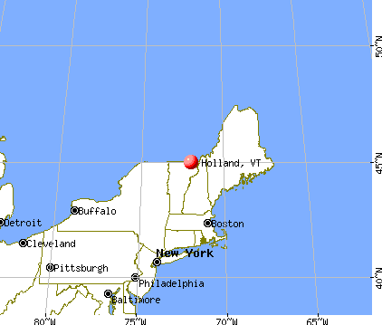
Nearest city with pop. 50,000+: Portland, ME  (124.8 miles , pop. 64,249).
Nearest city with pop. 200,000+: Boston, MA (188.9 miles , pop. 589,141).
Nearest city with pop. 1,000,000+: Bronx, NY (300.4 miles , pop. 1,332,650).
Nearest cities:
), ), ), ), )Latitude: 44.97 N, Longitude: 72.01 W
Area code commonly used in this area: 802

| Here: | 4.6% |
| Vermont: | 2.0% |
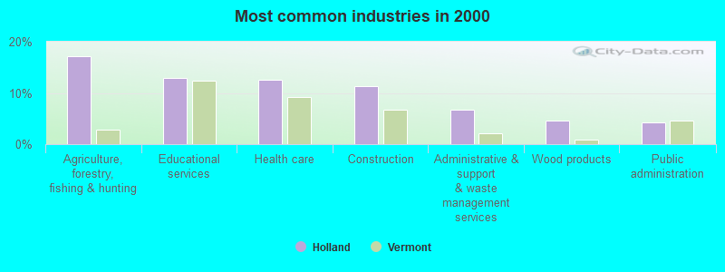
- Agriculture, forestry, fishing & hunting (17.1%)
- Educational services (12.9%)
- Health care (12.5%)
- Construction (11.2%)
- Administrative & support & waste management services (6.7%)
- Wood products (4.6%)
- Public administration (4.2%)
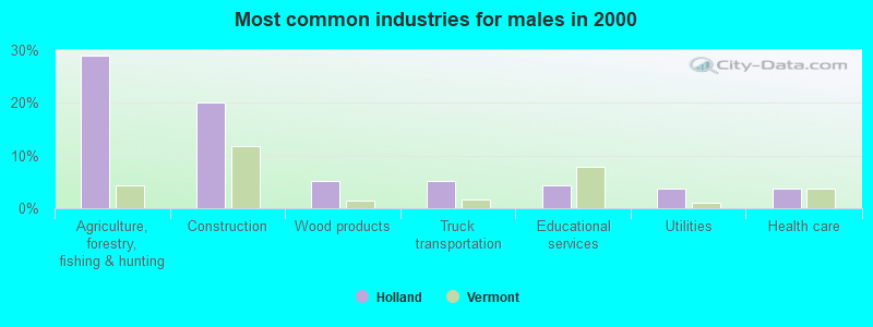
- Agriculture, forestry, fishing & hunting (28.9%)
- Construction (20.0%)
- Wood products (5.2%)
- Truck transportation (5.2%)
- Educational services (4.4%)
- Utilities (3.7%)
- Health care (3.7%)
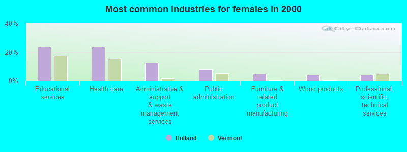
- Educational services (23.8%)
- Health care (23.8%)
- Administrative & support & waste management services (12.4%)
- Public administration (7.6%)
- Furniture & related product manufacturing (4.8%)
- Wood products (3.8%)
- Professional, scientific, technical services (3.8%)
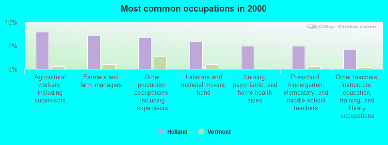
- Agricultural workers, including supervisors (7.9%)
- Farmers and farm managers (7.1%)
- Other production occupations, including supervisors (6.7%)
- Laborers and material movers, hand (5.8%)
- Nursing, psychiatric, and home health aides (5.0%)
- Preschool, kindergarten, elementary, and middle school teachers (5.0%)
- Other teachers, instructors, education, training, and library occupations (4.2%)
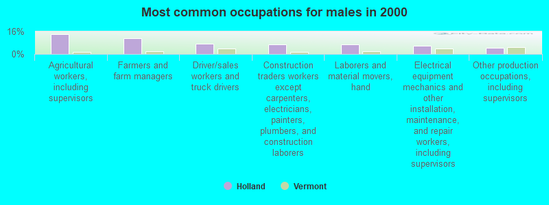
- Agricultural workers, including supervisors (14.1%)
- Farmers and farm managers (11.1%)
- Driver/sales workers and truck drivers (7.4%)
- Construction traders workers except carpenters, electricians, painters, plumbers, and construction laborers (6.7%)
- Laborers and material movers, hand (6.7%)
- Electrical equipment mechanics and other installation, maintenance, and repair workers, including supervisors (5.9%)
- Other production occupations, including supervisors (4.4%)
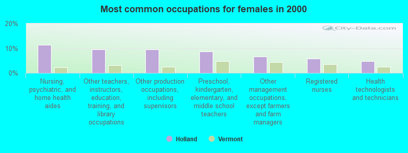
- Nursing, psychiatric, and home health aides (11.4%)
- Other teachers, instructors, education, training, and library occupations (9.5%)
- Other production occupations, including supervisors (9.5%)
- Preschool, kindergarten, elementary, and middle school teachers (8.6%)
- Other management occupations, except farmers and farm managers (6.7%)
- Registered nurses (5.7%)
- Health technologists and technicians (4.8%)
Average climate in Holland, Vermont
Based on data reported by over 4,000 weather stations


Earthquake activity:
Holland-area historical earthquake activity is significantly above Vermont state average. It is 77% smaller than the overall U.S. average.On 4/20/2002 at 10:50:47, a magnitude 5.3 (5.3 ML, Depth: 3.0 mi, Class: Moderate, Intensity: VI - VII) earthquake occurred 88.7 miles away from the city center
On 4/20/2002 at 10:50:47, a magnitude 5.2 (5.2 MB, 4.2 MS, 5.2 MW, 5.0 MW) earthquake occurred 90.3 miles away from the city center
On 10/7/1983 at 10:18:46, a magnitude 5.3 (5.1 MB, 5.3 LG, 5.1 ML) earthquake occurred 134.9 miles away from the city center
On 1/19/1982 at 00:14:42, a magnitude 4.7 (4.5 MB, 4.7 MD, 4.5 LG, Class: Light, Intensity: IV - V) earthquake occurred 103.7 miles away from the city center
On 10/16/2012 at 23:12:25, a magnitude 4.7 (4.7 ML, Depth: 10.0 mi) earthquake occurred 116.2 miles away from Holland center
On 6/16/1995 at 12:13:11, a magnitude 3.8 (3.8 LG, Depth: 3.1 mi, Class: Light, Intensity: II - III) earthquake occurred 47.5 miles away from the city center
Magnitude types: regional Lg-wave magnitude (LG), body-wave magnitude (MB), duration magnitude (MD), local magnitude (ML), surface-wave magnitude (MS), moment magnitude (MW)
Natural disasters:
The number of natural disasters in Orleans County (23) is greater than the US average (15).Major Disasters (Presidential) Declared: 17
Emergencies Declared: 2
Causes of natural disasters: Floods: 16, Storms: 14, Tropical Storms: 2, Winds: 2, Winter Storms: 2, Heavy Rain: 1, Hurricane: 1, Landslide: 1, Snowstorm: 1, Tornado: 1, Other: 1 (Note: some incidents may be assigned to more than one category).

Hospitals and medical centers near Holland:
- NEWPORT HEALTH CARE CENTER (Nursing Home, about 10 miles away; NEWPORT, VT)
- ORLEANS ESSEX VNA AND HOSPICE (Home Health Center, about 10 miles away; NEWPORT, VT)
- FLETCHER ALLEN HEALTHCARE - NORTH COUNTRY DIALYSIS UNIT (Dialysis Facility, about 10 miles away; NEWPORT, VT)
- NORTH COUNTRY HOSPITAL AND HEALTH CENTER Critical Access Hospitals (about 10 miles away; NEWPORT, VT)
Colleges/universities with over 2000 students nearest to Holland:
- Saint Michael's College (about 66 miles; Colchester, VT; Full-time enrollment: 2,336)
- Norwich University (about 66 miles; Northfield, VT; FT enrollment: 4,221)
- Community College of Vermont (about 67 miles; Winooski, VT; FT enrollment: 3,394)
- University of Vermont (about 68 miles; Burlington, VT; FT enrollment: 11,566)
- Champlain College (about 69 miles; Burlington, VT; FT enrollment: 2,623)
- SUNY College at Plattsburgh (about 75 miles; Plattsburgh, NY; FT enrollment: 5,934)
- Plymouth State University (about 86 miles; Plymouth, NH; FT enrollment: 4,838)
Points of interest:
Church in Holland: Holland Congregational Church (A). Display/hide its location on the map
Cemeteries: Moon Cemetery (1), Tice-Marston-Moon Cemetery (2), Mead Hill Cemetery (3), Davis Cemetery (4), Castle Cemetery (5), Mead Hill Cemetery (6). Display/hide their locations on the map
Lakes: Duck Pond (A), Beaver Pond (B), Round Pond (C), Holland Pond (D), Turtle Pond (E), Mud Pond (F). Display/hide their locations on the map
Birthplace of: William S. Ladd - Banker, Horace Tabor - Politician.
| This town: | 2.5 people |
| Vermont: | 2.3 people |
| This town: | 69.3% |
| Whole state: | 62.5% |
| This town: | 9.7% |
| Whole state: | 9.2% |
Likely homosexual households (counted as self-reported same-sex unmarried-partner households)
- Lesbian couples: 0.4% of all households
- Gay men: 0.4% of all households
| This town: | 15.1% |
| Whole state: | 9.4% |
| This town: | 4.5% |
| Whole state: | 3.6% |
For population 15 years and over in Holland:
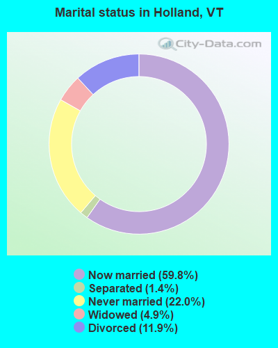
- Never married: 22.0%
- Now married: 59.8%
- Separated: 1.4%
- Widowed: 4.9%
- Divorced: 11.9%
For population 25 years and over in Holland:
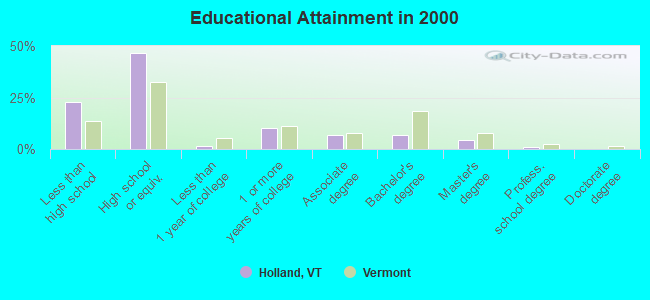
- High school or higher: 77.1%
- Bachelor's degree or higher: 11.6%
- Graduate or professional degree: 5.0%
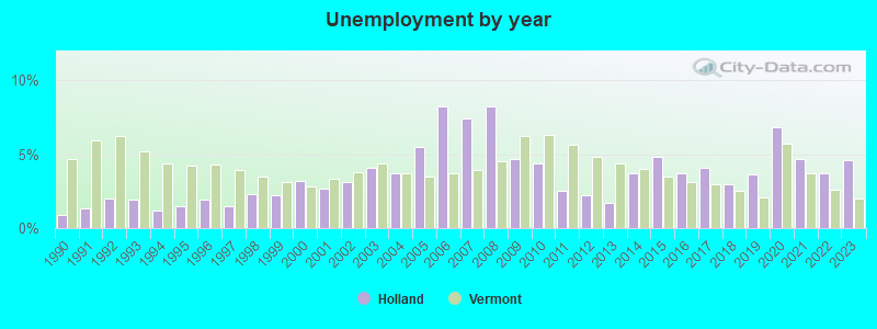
- Unemployed: 7.3%
- Mean travel time to work (commute): 22.5 minutes
| Here: | 12.6 |
| Vermont average: | 11.7 |
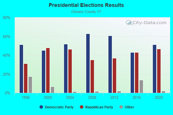
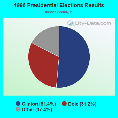
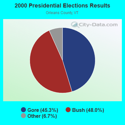
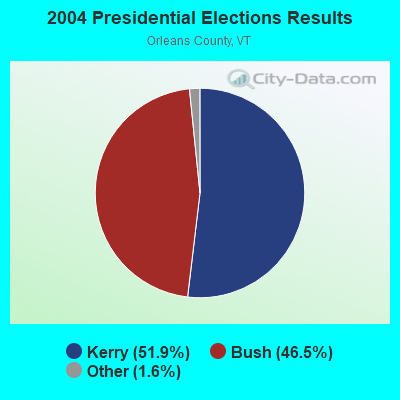
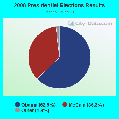
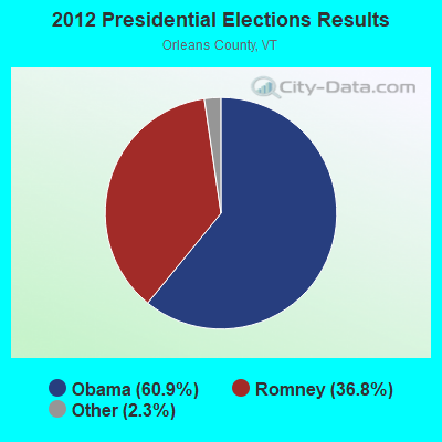
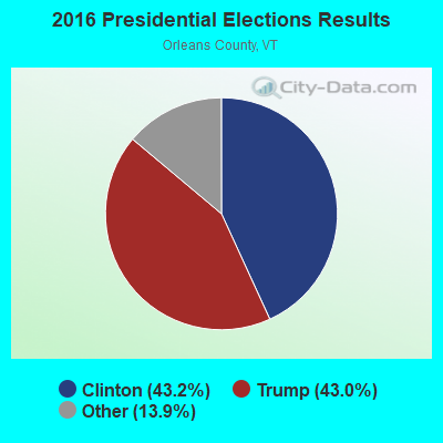
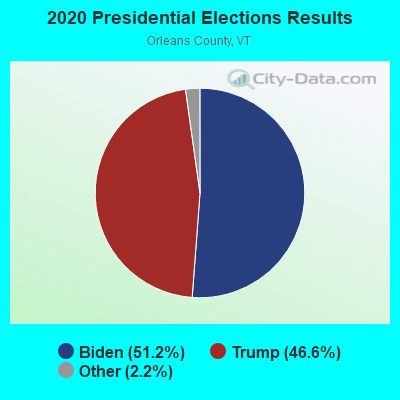
Graphs represent county-level data. Detailed 2008 Election Results
Religion statistics for Holland, VT (based on Orleans County data)
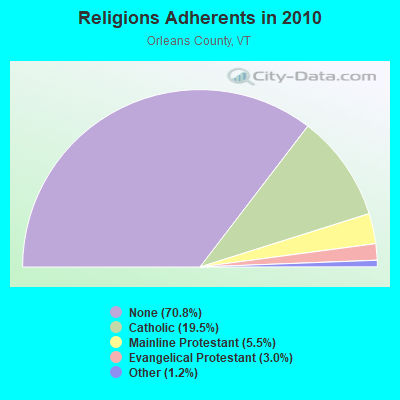
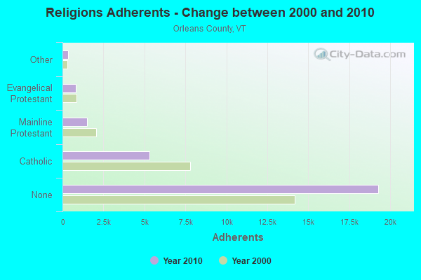
| Religion | Adherents | Congregations |
|---|---|---|
| Catholic | 5,312 | 12 |
| Mainline Protestant | 1,485 | 23 |
| Evangelical Protestant | 822 | 14 |
| Other | 323 | 4 |
| None | 19,289 | - |
Food Environment Statistics:
| Here: | 5.14 / 10,000 pop. |
| Vermont: | 3.84 / 10,000 pop. |
| Orleans County: | 1.10 / 10,000 pop. |
| Vermont: | 1.95 / 10,000 pop. |
| This county: | 6.60 / 10,000 pop. |
| Vermont: | 6.40 / 10,000 pop. |
| Here: | 8.07 / 10,000 pop. |
| State: | 11.52 / 10,000 pop. |
| Orleans County: | 7.0% |
| State: | 6.8% |
| Orleans County: | 24.8% |
| State: | 22.3% |
| Orleans County: | 10.8% |
| Vermont: | 13.3% |
Strongest AM radio stations in Holland:
- WCHP (760 AM; 35 kW; CHAMPLAIN, NY; Owner: CHAMPLAIN RADIO, INC.)
- WIKE (1490 AM; 1 kW; NEWPORT, VT; Owner: NORTHSTAR MEDIA, INC.)
- WICY (1490 AM; 50 kW; MALONE, NY; Owner: CARTIER COMMUNICATIONS INC.)
- WDEV (550 AM; 5 kW; WATERBURY, VT; Owner: RADIO VERMONT, INC.)
- WRKO (680 AM; 50 kW; BOSTON, MA; Owner: ENTERCOM BOSTON LICENSE, LLC)
- WTME (780 AM; 10 kW; RUMFORD, ME; Owner: MOUNTAIN VALLEY BROADCASTING, INC.)
- WNNZ (640 AM; 50 kW; WESTFIELD, MA; Owner: CLEAR CHANNEL BROADCASTING LICENSES, INC.)
- WGY (810 AM; 50 kW; SCHENECTADY, NY; Owner: CLEAR CHANNEL BROADCASTING LICENSES, INC.)
- WVMT (620 AM; 5 kW; BURLINGTON, VT; Owner: SISON BROADCASTING, INC.)
- WCRN (830 AM; 50 kW; WORCESTER, MA; Owner: CARTER BROADCASTING CORPORATION)
- WEEI (850 AM; 50 kW; BOSTON, MA; Owner: ENTERCOM BOSTON LICENSE, LLC)
- WTWN (1100 AM; daytime; 5 kW; WELLS RIVER, VT; Owner: PUFFER BROADCASTING, INC.)
- WBZ (1030 AM; 50 kW; BOSTON, MA; Owner: INFINITY BROADCASTING OPERATIONS, INC.)
Strongest FM radio stations in Holland:
- WMOO (92.1 FM; DERBY CENTER, VT; Owner: NORTHSTAR MEDIA, INC.)
- WGMT (97.7 FM; LYNDON, VT; Owner: VERMONT BROADCAST ASSOCIATES, INC.)
- WPKQ (103.7 FM; NORTH CONWAY, NH; Owner: CITADEL BROADCASTING COMPANY)
- WHOM (94.9 FM; MT. WASHINGTON, NH; Owner: CITADEL BROADCASTING COMPANY)
- W243AE (96.5 FM; ORLEANS, VT; Owner: CHRISTIAN MINISTRIES, INC.)
- WLKC (103.3 FM; WATERBURY, VT; Owner: RADIO BROADCASTING SERVICES, INC.)
- WEZF (92.9 FM; BURLINGTON, VT; Owner: CAPSTAR TX LIMITED PARTNERSHIP)
- WVPS (107.9 FM; BURLINGTON, VT; Owner: VERMONT PUBLIC RADIO)
- WCVT (101.7 FM; STOWE, VT; Owner: RADIO VERMONT CLASSICS, L.L.C.)
- WNCS (104.7 FM; MONTPELIER, VT; Owner: MONTPELIER BROADCASTING, INC.)
- WDOT (95.7 FM; DANVILLE, VT; Owner: MONTPELIER BROADCASTING INC)
- WMTK (106.3 FM; LITTLETON, NH; Owner: VERMONT BROADCAST ASSOCIATES, INC.)
- WXXS (102.3 FM; LANCASTER, NH; Owner: BARRY P. LUNDERVILLE)
TV broadcast stations around Holland:
- W14CK (Channel 14; NEWPORT, VT; Owner: SMC COMMUNICATIONS, INC.)
- National Bridge Inventory (NBI) Statistics
- 2Number of bridges
- 7ft / 1.8mTotal length
- 80Total average daily traffic
- 84Total future (year 2029) average daily traffic
FCC Registered Amateur Radio Licenses:
2- Call Sign: KB1ENS, Licensee ID: L00168676, Grant Date: 11/02/1999, Expiration Date: 11/02/2009, Cancellation Date: 08/03/2001, Certifier: John M Wagner, Registrant: John M Wagner, 25 Tree Farm Rd, Holland, VT 05830
- Call Sign: N1QO, Previous Call Sign: KB1ENS, Licensee ID: L00168676, Grant Date: 07/02/2021, Expiration Date: 08/16/2031, Certifier: John M Wagner, Registrant: John M Wagner, 25 Tree Farm Rd, Holland, VT 05830

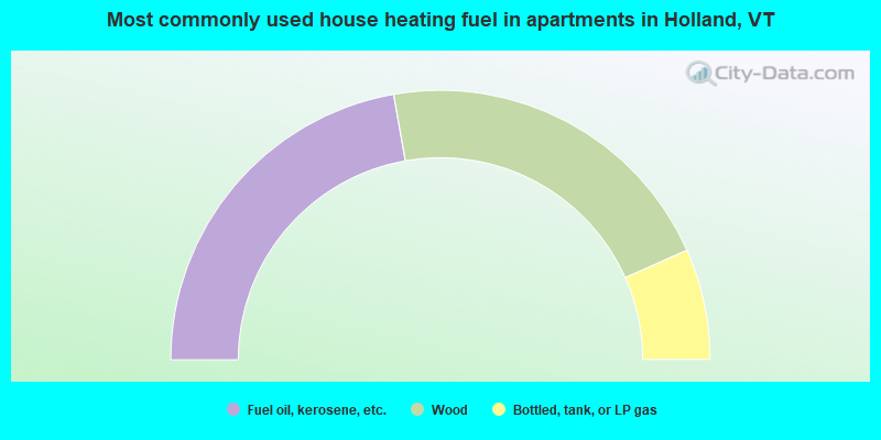
- 64.9%Fuel oil, kerosene, etc.
- 31.0%Wood
- 4.2%Bottled, tank, or LP gas
- 44.4%Fuel oil, kerosene, etc.
- 42.2%Wood
- 13.3%Bottled, tank, or LP gas
Holland compared to Vermont state average:
- Unemployed percentage below state average.
- Hispanic race population percentage below state average.
- Renting percentage significantly below state average.
- Length of stay since moving in significantly above state average.
- Number of rooms per house significantly below state average.
- House age significantly below state average.
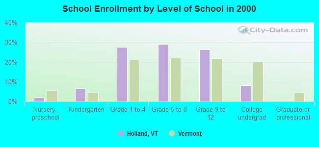
- Number of college students below state average.
- Percentage of population with a bachelor's degree or higher significantly below state average.
Holland on our top lists:
- #56 on the list of "Top 101 cities with the most residents born in Northern America (population 500+)"
- #56 on the list of "Top 101 cities with the most residents born in Canada (population 500+)"
- #101 (05830) on the list of "Top 101 zip codes with the largest percentage of French Canadian first ancestries"