Brownington, Vermont
Submit your own pictures of this town and show them to the world
- OSM Map
- Google Map
- MSN Map
Population change since 2000: +11.6%
 |
| Males: 490 | |
| Females: 498 |
| Median resident age: | 42.2 years |
| Vermont median age: | 45.8 years |
Zip codes: 05860.
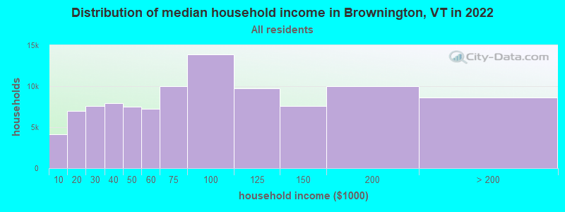
| Brownington: | $61,045 |
| VT: | $73,991 |
Estimated per capita income in 2022: $29,534 (it was $14,004 in 2000)
Brownington town income, earnings, and wages data
Estimated median house or condo value in 2022: $183,175 (it was $68,600 in 2000)
| Brownington: | $183,175 |
| VT: | $304,700 |
Mean prices in 2022: all housing units: $271,502; detached houses: $290,446; townhouses or other attached units: $299,602; in 2-unit structures: $159,589; in 3-to-4-unit structures: $395,771; in 5-or-more-unit structures: $253,965; mobile homes: $74,912
Detailed information about poverty and poor residents in Brownington, VT


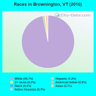
- 95596.7%White alone
- 121.2%Hispanic
- 90.9%Two or more races
- 80.8%American Indian alone
- 20.2%Black alone
- 10.1%Asian alone
- 10.1%Native Hawaiian and Other
Pacific Islander alone
Races in Brownington detailed stats: ancestries, foreign born residents, place of birth
According to our research of Vermont and other state lists, there were 4 registered sex offenders living in Brownington, Vermont as of May 17, 2024.
The ratio of all residents to sex offenders in Brownington is 247 to 1.
 Recent articles from our blog. Our writers, many of them Ph.D. graduates or candidates, create easy-to-read articles on a wide variety of topics.
Ancestries: French (23.6%), English (22.5%), Irish (12.0%), French Canadian (8.6%), United States (7.5%), Scottish (5.1%).
Current Local Time: EST time zone
Land area: 28.3 square miles.
Population density: 35 people per square mile (very low).
39 residents are foreign born (2.5% North America, 1.1% Europe, 0.5% Asia).
| This town: | 4.4% |
| Vermont: | 3.8% |
| Brownington town: | 1.5% ($1,007) |
| Vermont: | 2.0% ($2,196) |
Nearest city with pop. 50,000+: Portland, ME  (122.4 miles , pop. 64,249).
Nearest city with pop. 200,000+: Boston, MA (180.9 miles , pop. 589,141).
Nearest city with pop. 1,000,000+: Bronx, NY (289.0 miles , pop. 1,332,650).
Nearest cities:
), )Latitude: 44.83 N, Longitude: 72.13 W
Area code commonly used in this area: 802
| Here: | 5.0% |
| Vermont: | 2.0% |
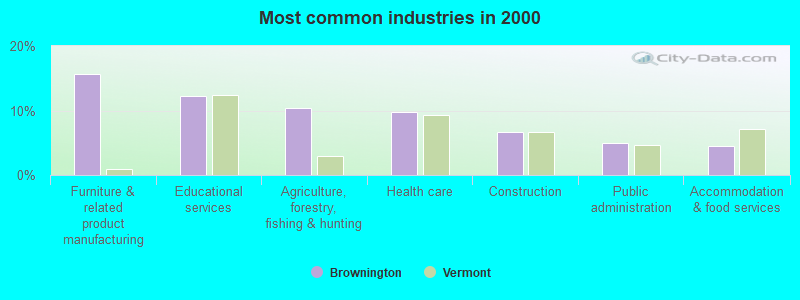
- Furniture & related product manufacturing (15.6%)
- Educational services (12.3%)
- Agriculture, forestry, fishing & hunting (10.4%)
- Health care (9.7%)
- Construction (6.6%)
- Public administration (5.0%)
- Accommodation & food services (4.5%)
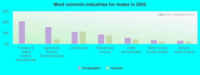
- Furniture & related product manufacturing (21.2%)
- Agriculture, forestry, fishing & hunting (15.9%)
- Construction (11.5%)
- Educational services (8.8%)
- Public administration (5.8%)
- Motor vehicle & parts dealers (3.5%)
- Metal & metal products (3.1%)
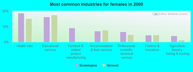
- Health care (18.8%)
- Educational services (16.2%)
- Furniture & related product manufacturing (9.1%)
- Accommodation & food services (7.1%)
- Professional, scientific, technical services (6.6%)
- Finance & insurance (4.6%)
- Agriculture, forestry, fishing & hunting (4.1%)
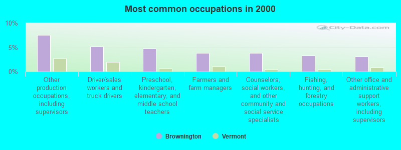
- Other production occupations, including supervisors (7.6%)
- Driver/sales workers and truck drivers (5.2%)
- Preschool, kindergarten, elementary, and middle school teachers (4.7%)
- Farmers and farm managers (3.8%)
- Counselors, social workers, and other community and social service specialists (3.8%)
- Fishing, hunting, and forestry occupations (3.3%)
- Other office and administrative support workers, including supervisors (3.1%)
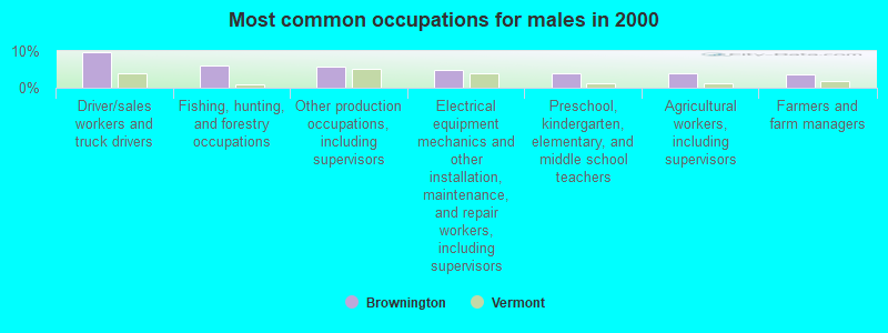
- Driver/sales workers and truck drivers (9.7%)
- Fishing, hunting, and forestry occupations (6.2%)
- Other production occupations, including supervisors (5.8%)
- Electrical equipment mechanics and other installation, maintenance, and repair workers, including supervisors (4.9%)
- Preschool, kindergarten, elementary, and middle school teachers (4.0%)
- Agricultural workers, including supervisors (4.0%)
- Farmers and farm managers (3.5%)
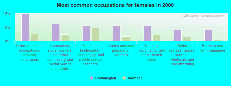
- Other production occupations, including supervisors (9.6%)
- Counselors, social workers, and other community and social service specialists (6.1%)
- Preschool, kindergarten, elementary, and middle school teachers (5.6%)
- Cooks and food preparation workers (5.6%)
- Nursing, psychiatric, and home health aides (5.6%)
- Sales representatives, services, wholesale and manufacturing (4.1%)
- Farmers and farm managers (4.1%)
Average climate in Brownington, Vermont
Based on data reported by over 4,000 weather stations


Earthquake activity:
Brownington-area historical earthquake activity is significantly above Vermont state average. It is 77% smaller than the overall U.S. average.On 4/20/2002 at 10:50:47, a magnitude 5.3 (5.3 ML, Depth: 3.0 mi, Class: Moderate, Intensity: VI - VII) earthquake occurred 79.9 miles away from the city center
On 4/20/2002 at 10:50:47, a magnitude 5.2 (5.2 MB, 4.2 MS, 5.2 MW, 5.0 MW) earthquake occurred 81.4 miles away from Brownington center
On 10/7/1983 at 10:18:46, a magnitude 5.3 (5.1 MB, 5.3 LG, 5.1 ML) earthquake occurred 124.7 miles away from the city center
On 1/19/1982 at 00:14:42, a magnitude 4.7 (4.5 MB, 4.7 MD, 4.5 LG, Class: Light, Intensity: IV - V) earthquake occurred 95.4 miles away from the city center
On 10/16/2012 at 23:12:25, a magnitude 4.7 (4.7 ML, Depth: 10.0 mi) earthquake occurred 112.2 miles away from Brownington center
On 6/16/1995 at 12:13:11, a magnitude 3.8 (3.8 LG, Depth: 3.1 mi, Class: Light, Intensity: II - III) earthquake occurred 38.9 miles away from Brownington center
Magnitude types: regional Lg-wave magnitude (LG), body-wave magnitude (MB), duration magnitude (MD), local magnitude (ML), surface-wave magnitude (MS), moment magnitude (MW)
Natural disasters:
The number of natural disasters in Orleans County (23) is greater than the US average (15).Major Disasters (Presidential) Declared: 17
Emergencies Declared: 2
Causes of natural disasters: Floods: 16, Storms: 14, Tropical Storms: 2, Winds: 2, Winter Storms: 2, Heavy Rain: 1, Hurricane: 1, Landslide: 1, Snowstorm: 1, Tornado: 1, Other: 1 (Note: some incidents may be assigned to more than one category).
Hospitals and medical centers near Brownington:
- MAPLE LANE NURSING HOME (Nursing Home, about 9 miles away; BARTON, VT)
- NEWPORT HEALTH CARE CENTER (Nursing Home, about 10 miles away; NEWPORT, VT)
- ORLEANS ESSEX VNA AND HOSPICE (Home Health Center, about 10 miles away; NEWPORT, VT)
- FLETCHER ALLEN HEALTHCARE - NORTH COUNTRY DIALYSIS UNIT (Dialysis Facility, about 10 miles away; NEWPORT, VT)
- NORTH COUNTRY HOSPITAL AND HEALTH CENTER Critical Access Hospitals (about 10 miles away; NEWPORT, VT)
- UNION HOUSE NURSING HOME (Nursing Home, about 12 miles away; GLOVER, VT)
Colleges/universities with over 2000 students nearest to Brownington:
- Norwich University (about 55 miles; Northfield, VT; Full-time enrollment: 4,221)
- Saint Michael's College (about 56 miles; Colchester, VT; FT enrollment: 2,336)
- Community College of Vermont (about 57 miles; Winooski, VT; FT enrollment: 3,394)
- University of Vermont (about 58 miles; Burlington, VT; FT enrollment: 11,566)
- Champlain College (about 59 miles; Burlington, VT; FT enrollment: 2,623)
- SUNY College at Plattsburgh (about 67 miles; Plattsburgh, NY; FT enrollment: 5,934)
- Middlebury College (about 77 miles; Middlebury, VT; FT enrollment: 3,077)
Public elementary/middle school in Brownington:
- BROWNINGTON CENTRAL SCHOOL (Students: 75, Location: 103 CHASE ROAD, Grades: PK-8)
Points of interest:
Notable locations in Brownington: Will-O-Wood Campground (A), Athenian Hall (B), Orleans County Historical Society Museum (C), Orleans County Historical Society Building (D), Old Stone House Library (E), Old Stone House (F). Display/hide their locations on the map
Cemeteries: Brownington Village Cemetery (1), Brownington Center Cemetery (2), East Cemetery (3), North Cemetery (4), East Brownington Cemetery (5). Display/hide their locations on the map
Lakes and reservoirs: Brownington Pond (A), Lubber Lake (B). Display/hide their locations on the map
Streams, rivers, and creeks: Moody Brook (A), Lord Brook (B), Dutton Brook (C), Bassett Brook (D), Wells Brook (E), Brownington Branch (F). Display/hide their locations on the map
Park in Brownington: Brownington Village Historic District (1). Display/hide its location on the map
Birthplace of: James Strong (college president) - Congregationalist cleric.
Drinking water stations with addresses in Brownington and their reported violations in the past:
WILLOWOOD CAMPGROUND (Address: 227 WILL-O-WOOD LN , Population served: 400, Groundwater):Past health violations:BROWNINGTON CENTER SCHOOL (Address: 103 CHASE RD , Population served: 120, Groundwater):Past monitoring violations:
- MCL, Monthly (TCR) - In AUG-2012, Contaminant: Coliform. Follow-up actions: St Tech Assistance Visit (AUG-10-2012), St Formal NOV issued (AUG-10-2012), St Public Notif requested (AUG-10-2012), St Boil Water Order (AUG-10-2012), St Compliance achieved (SEP-30-2013)
- MCL, Monthly (TCR) - In OCT-2008, Contaminant: Coliform. Follow-up actions: St Public Notif requested (OCT-22-2008), St Formal NOV issued (OCT-22-2008), St Compliance achieved (AUG-09-2010)
- 2 routine major monitoring violations
- One minor monitoring violation
Past monitoring violations:
- Follow-up Or Routine LCR Tap M/R - In OCT-01-2007, Contaminant: Lead and Copper Rule. Follow-up actions: St Public Notif requested (DEC-11-2007), St Formal NOV issued (DEC-11-2007), St Public Notif received (DEC-21-2007), St Compliance achieved (APR-27-2011)
- 2 routine major monitoring violations
| This town: | 2.5 people |
| Vermont: | 2.3 people |
| This town: | 68.7% |
| Whole state: | 62.5% |
| This town: | 12.0% |
| Whole state: | 9.2% |
Likely homosexual households (counted as self-reported same-sex unmarried-partner households)
- Lesbian couples: 0.5% of all households
- Gay men: 0.0% of all households
| This town: | 17.9% |
| Whole state: | 9.4% |
| This town: | 5.7% |
| Whole state: | 3.6% |
For population 15 years and over in Brownington:
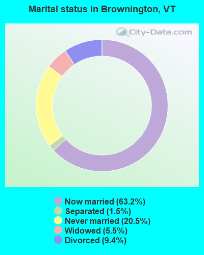
- Never married: 20.5%
- Now married: 63.2%
- Separated: 1.5%
- Widowed: 5.5%
- Divorced: 9.4%
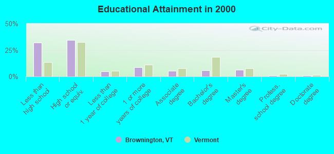
For population 25 years and over in Brownington:
- High school or higher: 67.7%
- Bachelor's degree or higher: 14.3%
- Graduate or professional degree: 8.3%
- Unemployed: 4.3%
- Mean travel time to work (commute): 25.1 minutes
| Here: | 12.5 |
| Vermont average: | 11.7 |
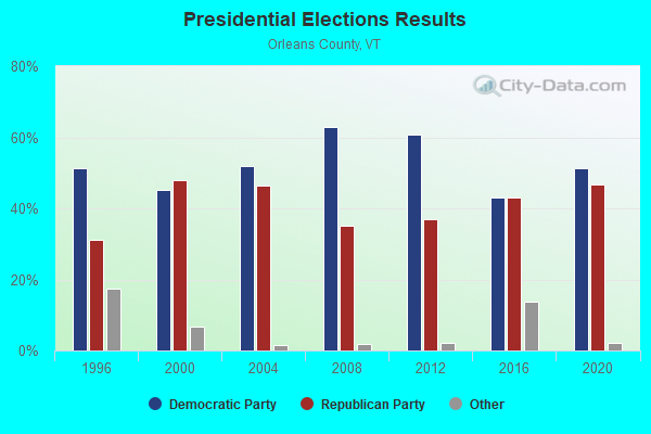
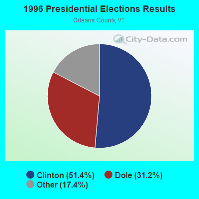
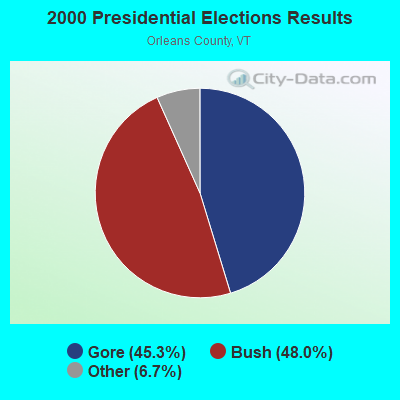
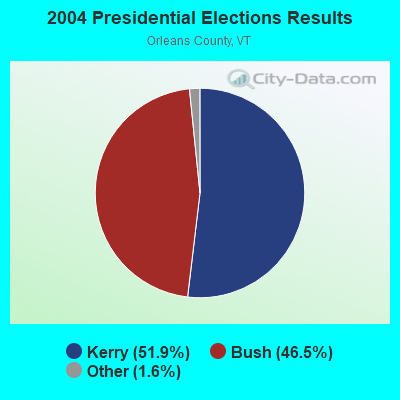
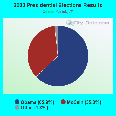
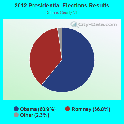
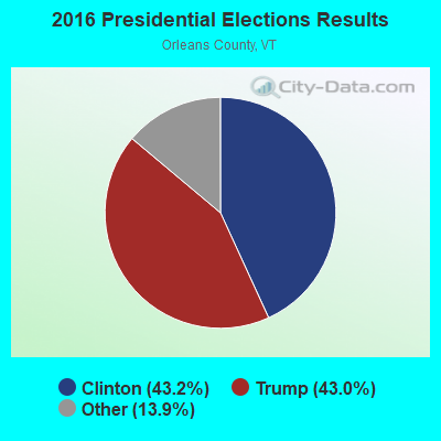
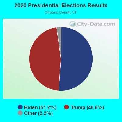
Graphs represent county-level data. Detailed 2008 Election Results
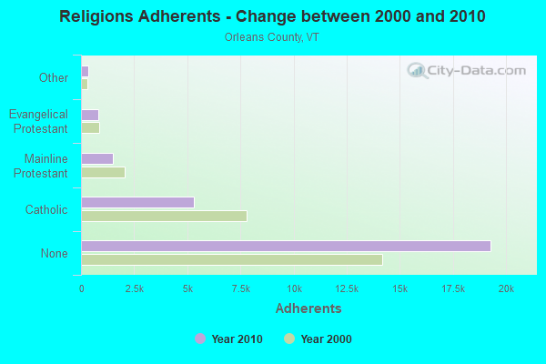
Religion statistics for Brownington, VT (based on Orleans County data)
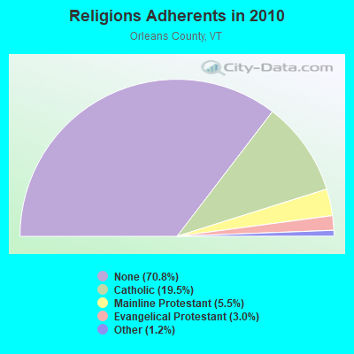
| Religion | Adherents | Congregations |
|---|---|---|
| Catholic | 5,312 | 12 |
| Mainline Protestant | 1,485 | 23 |
| Evangelical Protestant | 822 | 14 |
| Other | 323 | 4 |
| None | 19,289 | - |
Food Environment Statistics:
| This county: | 5.14 / 10,000 pop. |
| Vermont: | 3.84 / 10,000 pop. |
| Orleans County: | 1.10 / 10,000 pop. |
| State: | 1.95 / 10,000 pop. |
| Orleans County: | 6.60 / 10,000 pop. |
| Vermont: | 6.40 / 10,000 pop. |
| Orleans County: | 8.07 / 10,000 pop. |
| State: | 11.52 / 10,000 pop. |
| Orleans County: | 7.0% |
| Vermont: | 6.8% |
| Orleans County: | 24.8% |
| Vermont: | 22.3% |
| This county: | 10.8% |
| Vermont: | 13.3% |
Strongest AM radio stations in Brownington:
- WCHP (760 AM; 35 kW; CHAMPLAIN, NY; Owner: CHAMPLAIN RADIO, INC.)
- WIKE (1490 AM; 1 kW; NEWPORT, VT; Owner: NORTHSTAR MEDIA, INC.)
- WDEV (550 AM; 5 kW; WATERBURY, VT; Owner: RADIO VERMONT, INC.)
- WICY (1490 AM; 50 kW; MALONE, NY; Owner: CARTIER COMMUNICATIONS INC.)
- WRKO (680 AM; 50 kW; BOSTON, MA; Owner: ENTERCOM BOSTON LICENSE, LLC)
- WVMT (620 AM; 5 kW; BURLINGTON, VT; Owner: SISON BROADCASTING, INC.)
- WNNZ (640 AM; 50 kW; WESTFIELD, MA; Owner: CLEAR CHANNEL BROADCASTING LICENSES, INC.)
- WGY (810 AM; 50 kW; SCHENECTADY, NY; Owner: CLEAR CHANNEL BROADCASTING LICENSES, INC.)
- WTWN (1100 AM; daytime; 5 kW; WELLS RIVER, VT; Owner: PUFFER BROADCASTING, INC.)
- WCRN (830 AM; 50 kW; WORCESTER, MA; Owner: CARTER BROADCASTING CORPORATION)
- WTME (780 AM; 10 kW; RUMFORD, ME; Owner: MOUNTAIN VALLEY BROADCASTING, INC.)
- WEEI (850 AM; 50 kW; BOSTON, MA; Owner: ENTERCOM BOSTON LICENSE, LLC)
- WBZ (1030 AM; 50 kW; BOSTON, MA; Owner: INFINITY BROADCASTING OPERATIONS, INC.)
Strongest FM radio stations in Brownington:
- W243AE (96.5 FM; ORLEANS, VT; Owner: CHRISTIAN MINISTRIES, INC.)
- WMOO (92.1 FM; DERBY CENTER, VT; Owner: NORTHSTAR MEDIA, INC.)
- WGMT (97.7 FM; LYNDON, VT; Owner: VERMONT BROADCAST ASSOCIATES, INC.)
- WLKC (103.3 FM; WATERBURY, VT; Owner: RADIO BROADCASTING SERVICES, INC.)
- WEZF (92.9 FM; BURLINGTON, VT; Owner: CAPSTAR TX LIMITED PARTNERSHIP)
- WVPS (107.9 FM; BURLINGTON, VT; Owner: VERMONT PUBLIC RADIO)
- WPKQ (103.7 FM; NORTH CONWAY, NH; Owner: CITADEL BROADCASTING COMPANY)
- WHOM (94.9 FM; MT. WASHINGTON, NH; Owner: CITADEL BROADCASTING COMPANY)
- WCVT (101.7 FM; STOWE, VT; Owner: RADIO VERMONT CLASSICS, L.L.C.)
- WNCS (104.7 FM; MONTPELIER, VT; Owner: MONTPELIER BROADCASTING, INC.)
- WDOT (95.7 FM; DANVILLE, VT; Owner: MONTPELIER BROADCASTING INC)
- WMTK (106.3 FM; LITTLETON, NH; Owner: VERMONT BROADCAST ASSOCIATES, INC.)
- WDEV-FM (96.1 FM; WARREN, VT; Owner: RADIO VERMONT, INC.)
- WCKJ (90.5 FM; ST. JOHNSBURY, VT; Owner: CHRISTIAN MINISTRIES, INC.)
- WKXH (105.5 FM; ST. JOHNSBURY, VT; Owner: VERMONT BROADCAST ASSOCIATES, INC.)
- WXXS (102.3 FM; LANCASTER, NH; Owner: BARRY P. LUNDERVILLE)
TV broadcast stations around Brownington:
- W14CK (Channel 14; NEWPORT, VT; Owner: SMC COMMUNICATIONS, INC.)
- National Bridge Inventory (NBI) Statistics
- 5Number of bridges
- 36ft / 10.7mTotal length
- $212,000Total costs
- 1,610Total average daily traffic
- 69Total average daily truck traffic
- 1,692Total future (year 2028) average daily traffic
FCC Registered Antenna Towers:
11 (See the full list of FCC Registered Antenna Towers in Brownington)FCC Registered Broadcast Land Mobile Towers:
1- Mobile Radios, Lat: 44.818917 Lon: -72.136250, Call Sign: WQWE950,
Assigned Frequencies: 158.760 MHz, Grant Date: 08/04/2015, Expiration Date: 08/04/2025, Certifier: Beverly J White, Registrant: Clark Communication Electronics, 18 Landfill Rd., Milton, VT 05468, Phone: (802) 893-7078, Fax: (802) 893-4732, Email:
FCC Registered Microwave Towers:
1- BROWNINGTON, Off Hinman Road (Lat: 44.843889 Lon: -72.158056), Type: Tower, Structure height: 29 m, Call Sign: WPUY211,
Assigned Frequencies: 6404.79 MHz, 6226.89 MHz, Grant Date: 04/12/2022, Expiration Date: 05/24/2032, Certifier: Terry M Lavalley, Registrant: State Of Vermont, 45 State Drive, Watterbury, VT 05671, Phone: (802) 229-0882, Fax: (717) 671-0200, Email:
FCC Registered Amateur Radio Licenses:
2- Call Sign: W1JJ, Previous Call Sign: W1JJM, Licensee ID: L00170909, Grant Date: 03/02/2023, Expiration Date: 03/02/2033, Certifier: John J Mc Manus, Registrant: John J Mc Manus, 835 Ticehurst Road, Brownington, VT 05860
- Call Sign: AB1XT, Licensee ID: L01950333, Grant Date: 06/11/2015, Expiration Date: 06/11/2025, Certifier: Calvin F Page, Registrant: Calvin F Page, 26 Willoughby Lake Rd, Brownington, VT 05860
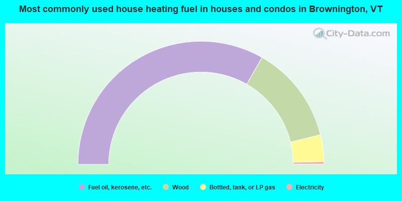
- 66.6%Fuel oil, kerosene, etc.
- 25.8%Wood
- 7.0%Bottled, tank, or LP gas
- 0.7%Electricity
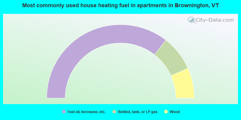
- 71.1%Fuel oil, kerosene, etc.
- 15.6%Bottled, tank, or LP gas
- 13.3%Wood
Brownington compared to Vermont state average:
- Median house value below state average.
- Unemployed percentage significantly below state average.
- Black race population percentage significantly below state average.
- Renting percentage significantly below state average.
- Length of stay since moving in significantly above state average.
- Number of rooms per house significantly below state average.
- House age significantly below state average.
- Number of college students below state average.
- Percentage of population with a bachelor's degree or higher below state average.

|
Total of 1 patent application in 2008-2024.