Kirkmansville, Kentucky
Submit your own pictures of this place and show them to the world
- OSM Map
- General Map
- Google Map
- MSN Map

| Males: 1,466 | |
| Females: 1,468 |
| Median resident age: | 36.5 years |
| Kentucky median age: | 35.9 years |
Zip code: 42220
| Kirkmansville: | $51,937 |
| KY: | $59,341 |
Estimated per capita income in 2022: $28,351 (it was $14,292 in 2000)
Kirkmansville CCD income, earnings, and wages data
Estimated median house or condo value in 2022: $115,870 (it was $47,700 in 2000)
| Kirkmansville: | $115,870 |
| KY: | $196,300 |
Mean prices in 2022: all housing units: $151,748; detached houses: $163,867; townhouses or other attached units: $257,590; mobile homes: $60,636
Detailed information about poverty and poor residents in Kirkmansville, KY
Compare current foreclosures near Kirkmansville, KY:
| Photo | Address | Area | Beds / Baths | Price | Details |
|---|---|---|---|---|---|

|
#1
W Jeff Davis Hwy
Elkton, KY 42220
|
2,004 sq. feet
|
2 baths 3 beds |
show details | |

|
#2
Forest Park Blvd
Hopkinsville, KY 42240
|
1,180 sq. feet
|
1 baths 3 beds |
show details | |

|
#3
Greenville Rd
Hopkinsville, KY 42240
|
768 sq. feet
|
1 baths 2 beds |
show details | |

|
#4
Antioch Rd
Hopkinsville, KY 42240
|
1,265 sq. feet
|
1 baths 2 beds |
show details | |

|
#5
Cumbee Rd
Hopkinsville, KY 42240
|
1,558 sq. feet
|
2 baths 3 beds |
show details | |

|
#6
Old Quarry Rd
Elkton, KY 42220
|
1,288 sq. feet
|
1 baths 3 beds |
show details | |

|
#7
Marion St
Elkton, KY 42220
|
1,056 sq. feet
|
1 baths 2 beds |
show details | |

|
#8
Antioch Rd
Hopkinsville, KY 42240
|
956 sq. feet
|
1 baths 3 beds |
show details | |

|
#9
W Main St
Elkton, KY 42220
|
1,496 sq. feet
|
1 baths 2 beds |
show details | |

|
#10
N Main St
Elkton, KY 42220
|
940 sq. feet
|
1 baths 2 beds |
show details |
| Photo | Address | Area | Beds / Baths | Price | Details |
|---|---|---|---|---|---|

|
#11
Crofton Fruithill Rd
Crofton, KY 42217
|
1,344 sq. feet
|
1 baths 2 beds |
show details | |

|
#12
Greenville Rd
Elkton, KY 42220
|
1,088 sq. feet
|
1 baths 2 beds |
show details | |

|
#13
Shanklin Ln
Elkton, KY 42220
|
1,680 sq. feet
|
2 baths 3 beds |
show details | |

|
#14
Greenville Rd
Elkton, KY 42220
|
1,884 sq. feet
|
2 baths 3 beds |
show details | |

|
#15
Rock Cliff Dr
Hopkinsville, KY 42240
|
1,039 sq. feet
|
1 baths 3 beds |
show details | |

|
#16
Allegre Rd
Elkton, KY 42220
|
1,056 sq. feet
|
2 baths 3 beds |
show details | |

|
#17
Harris Rd
Elkton, KY 42220
|
1,930 sq. feet
|
1 baths 3 beds |
show details | |

|
#18
Old Madisonville Rd
Hopkinsville, KY 42240
|
1,536 sq. feet
|
1 baths 1 beds |
show details | |

|
#19
Valleyview Dr
Russellville, KY 42276
|
- sq. feet
|
- baths - beds |
show details | |

|
#20
State Route 2270 W
Belton, KY 42324
|
- sq. feet
|
- baths - beds |
show details |
| Photo | Address | Area | Beds / Baths | Price | Details |
|---|---|---|---|---|---|

|
#21
Clara Dr Apt 2h
Pembroke, KY 42266
|
- sq. feet
|
- baths - beds |
show details | |

|
#22
Devasher Road
Russellville, KY 42276
|
- sq. feet
|
- baths - beds |
show details | |

|
#23
Madisonville Rd
Hopkinsville, KY 42240
|
- sq. feet
|
- baths - beds |
show details | |

|
#24
Joyce Ave
Greenville, KY 42345
|
- sq. feet
|
- baths - beds |
show details | |

|
#25
Devasher Rd
Russellville, KY 42276
|
- sq. feet
|
- baths - beds |
show details | |

|
#26
Flowers Rd
Crofton, KY 42217
|
1,566 sq. feet
|
- baths - beds |
show details | |

|
#27
Joyce Ave
Greenville, KY 42345
|
- sq. feet
|
- baths - beds |
show details | |

|
#28
Us Highway 431 S
Beechmont, KY 42323
|
- sq. feet
|
- baths - beds |
show details | |

|
#29
Harris Rd
Belton, KY 42324
|
1,040 sq. feet
|
- baths - beds |
show details | |

|
#30
Robinwood Dr Apt 31
Greenville, KY 42345
|
- sq. feet
|
- baths - beds |
show details |
| Photo | Address | Area | Beds / Baths | Price | Details |
|---|---|---|---|---|---|

|
#31
J Knight Ext
Crofton, KY 42217
|
- sq. feet
|
- baths - beds |
show details | |

|
#32
Gospel Peace Rd
Hopkinsville, KY 42240
|
- sq. feet
|
- baths - beds |
show details | |

|
#33
Highland Lick Rd
Russellville, KY 42276
|
- sq. feet
|
- baths - beds |
show details | |

|
#34
Rabbit Ridge Rd
Elkton, KY 42220
|
- sq. feet
|
- baths - beds |
show details | |

|
#35
Fowler Rd
Lewisburg, KY 42256
|
- sq. feet
|
- baths - beds |
show details | |

|
#36
Roger Q Mill Rd
Pembroke, KY 42266
|
- sq. feet
|
- baths - beds |
show details | |

|
#37
Pilot Rock Rd
Elkton, KY 42220
|
- sq. feet
|
- baths - beds |
show details | |

|
#38
Scott Rd
Sharon Grove, KY 42280
|
- sq. feet
|
- baths - beds |
show details | |

|
#39
State Route 890
Greenville, KY 42345
|
1,368 sq. feet
|
- baths - beds |
show details | |

|
#40
Greenville Rd
Elkton, KY 42220
|
- sq. feet
|
- baths - beds |
show details |
| Photo | Address | Area | Beds / Baths | Price | Details |
|---|---|---|---|---|---|

|
#41
Dunmor Deer Lick Rd
Lewisburg, KY 42256
|
- sq. feet
|
- baths - beds |
show details | |

|
#42
Inn View Ln
Dunmor, KY 42339
|
- sq. feet
|
- baths - beds |
show details | |

|
#43
Moe Ln
Elkton, KY 42220
|
- sq. feet
|
- baths - beds |
show details | |

|
#44
N Main St
Elkton, KY 42220
|
- sq. feet
|
- baths - beds |
show details | |

|
#45
Kaylor Ln
Greenville, KY 42345
|
- sq. feet
|
- baths - beds |
show details | |

|
#46
W Jefferson St # B
Elkton, KY 42220
|
- sq. feet
|
- baths - beds |
show details | |

|
#47
Bells Chapel Rd
Trenton, KY 42286
|
- sq. feet
|
- baths - beds |
show details | |

|
#48
Kentucky 1473
Greenville, KY 42345
|
- sq. feet
|
- baths - beds |
show details | |

|
#49
Lamplight Ln
Lewisburg, KY 42256
|
- sq. feet
|
- baths - beds |
show details | |

|
Check over 1 million property listings on Foreclosure.com!
|
browse all offers | |||

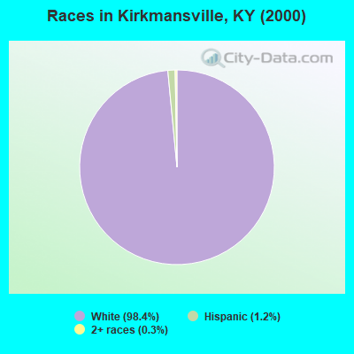
- 2,87198.4%White alone
- 351.2%Hispanic
- 90.3%Two or more races
- 10.03%Black alone
- 10.03%American Indian alone
- 10.03%Asian alone
- 10.03%Native Hawaiian and Other
Pacific Islander alone
Races in Kirkmansville detailed stats: ancestries, foreign born residents, place of birth
 Recent articles from our blog. Our writers, many of them Ph.D. graduates or candidates, create easy-to-read articles on a wide variety of topics.
Current Local Time: CST time zone
Land area: 135.3 square miles.
Population density: 22 people per square mile (very low).

| Kirkmansville CCD: | 0.5% ($231) |
| Kentucky: | 0.8% ($610) |
Nearest city with pop. 50,000+: Clarksville, TN  (30.5 miles , pop. 103,455).
Nearest city with pop. 200,000+: Metropolitan Government, TN (61.0 miles , pop. 569,891).
Nearest city with pop. 1,000,000+: Chicago, IL (337.6 miles , pop. 2,896,016).
Nearest cities:
), ), ), ), Latitude: 36.98 N, Longitude: 87.18 W
Area code commonly used in this area: 270

| Here: | 3.5% |
| Kentucky: | 3.8% |
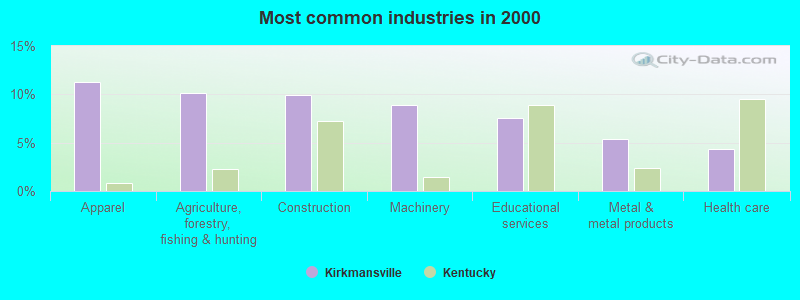
- Apparel (11.3%)
- Agriculture, forestry, fishing & hunting (10.2%)
- Construction (10.0%)
- Machinery (8.9%)
- Educational services (7.6%)
- Metal & metal products (5.3%)
- Health care (4.3%)
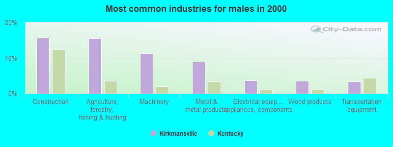
- Construction (15.7%)
- Agriculture, forestry, fishing & hunting (15.6%)
- Machinery (11.2%)
- Metal & metal products (9.0%)
- Electrical equipment, appliances, components (3.8%)
- Wood products (3.5%)
- Transportation equipment (3.4%)
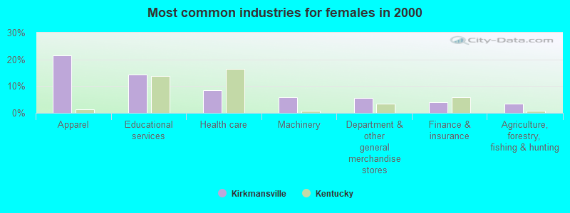
- Apparel (21.4%)
- Educational services (14.3%)
- Health care (8.5%)
- Machinery (6.0%)
- Department & other general merchandise stores (5.5%)
- Finance & insurance (3.9%)
- Agriculture, forestry, fishing & hunting (3.5%)
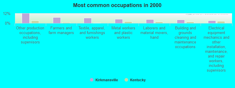
- Other production occupations, including supervisors (12.0%)
- Farmers and farm managers (7.2%)
- Textile, apparel, and furnishings workers (6.4%)
- Metal workers and plastic workers (5.0%)
- Laborers and material movers, hand (4.8%)
- Building and grounds cleaning and maintenance occupations (4.5%)
- Electrical equipment mechanics and other installation, maintenance, and repair workers, including supervisors (3.4%)
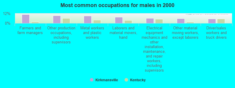
- Farmers and farm managers (10.8%)
- Other production occupations, including supervisors (9.3%)
- Metal workers and plastic workers (9.0%)
- Laborers and material movers, hand (7.6%)
- Electrical equipment mechanics and other installation, maintenance, and repair workers, including supervisors (6.1%)
- Other material moving workers, except laborers (5.9%)
- Driver/sales workers and truck drivers (5.4%)
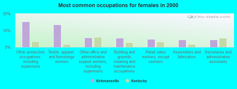
- Other production occupations, including supervisors (15.3%)
- Textile, apparel, and furnishings workers (13.4%)
- Other office and administrative support workers, including supervisors (5.6%)
- Building and grounds cleaning and maintenance occupations (5.5%)
- Retail sales workers, except cashiers (4.8%)
- Assemblers and fabricators (4.5%)
- Secretaries and administrative assistants (4.5%)
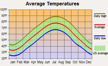
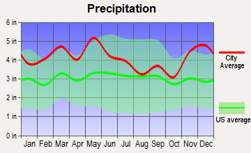
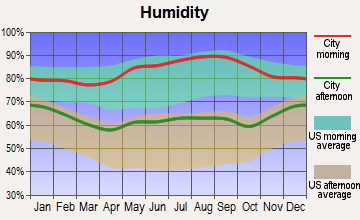
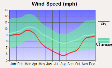
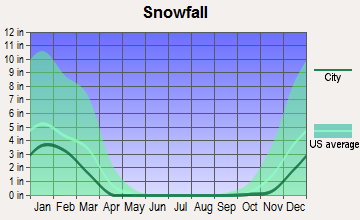
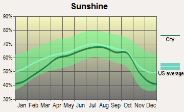
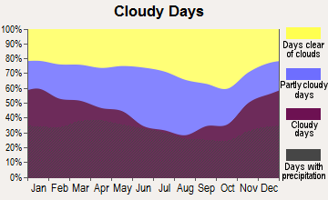
Average climate in Kirkmansville, Kentucky
Based on data reported by over 4,000 weather stations
(lower is better)
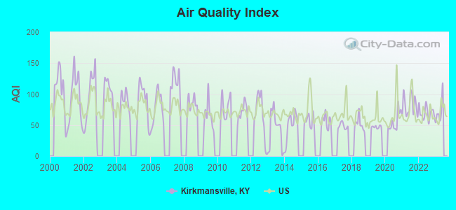
Air Quality Index (AQI) level in 2022 was 69.7. This is about average.
| City: | 69.7 |
| U.S.: | 72.6 |
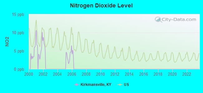
Nitrogen Dioxide (NO2) [ppb] level in 2005 was 3.65. This is significantly better than average. Closest monitor was 9.3 miles away from the city center.
| City: | 3.65 |
| U.S.: | 5.11 |
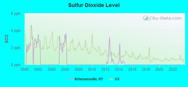
Sulfur Dioxide (SO2) [ppb] level in 2014 was 0.598. This is significantly better than average. Closest monitor was 9.3 miles away from the city center.
| City: | 0.598 |
| U.S.: | 1.515 |
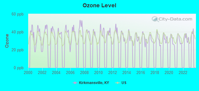
Ozone [ppb] level in 2022 was 33.7. This is about average. Closest monitor was 9.3 miles away from the city center.
| City: | 33.7 |
| U.S.: | 33.3 |
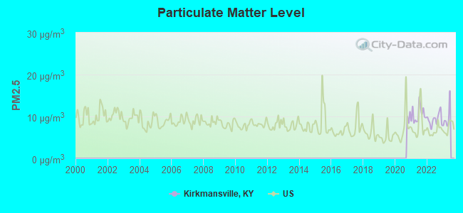
Particulate Matter (PM2.5) [µg/m3] level in 2022 was 9.31. This is about average. Closest monitor was 9.3 miles away from the city center.
| City: | 9.31 |
| U.S.: | 8.11 |
Tornado activity:
Kirkmansville-area historical tornado activity is slightly above Kentucky state average. It is 55% greater than the overall U.S. average.
On 4/3/1968, a category F4 (max. wind speeds 207-260 mph) tornado 27.0 miles away from the Kirkmansville place center killed 2 people and injured 30 people and caused between $500,000 and $5,000,000 in damages.
On 11/15/2005, a category F4 tornado 27.3 miles away from the place center injured 40 people and caused $31 million in damages.
Earthquake activity:
Kirkmansville-area historical earthquake activity is significantly above Kentucky state average. It is 214% greater than the overall U.S. average.On 4/18/2008 at 09:36:59, a magnitude 5.4 (5.1 MB, 4.8 MS, 5.4 MW, 5.2 MW, Class: Moderate, Intensity: VI - VII) earthquake occurred 109.3 miles away from Kirkmansville center
On 4/18/2008 at 09:36:59, a magnitude 5.2 (5.2 MW, Depth: 8.9 mi) earthquake occurred 109.3 miles away from the city center
On 6/18/2002 at 17:37:15, a magnitude 5.0 (4.3 MB, 4.6 MW, 5.0 LG) earthquake occurred 77.4 miles away from Kirkmansville center
On 6/10/1987 at 23:48:54, a magnitude 5.1 (4.9 MB, 4.4 MS, 4.6 MS, 5.1 LG) earthquake occurred 133.4 miles away from Kirkmansville center
On 9/26/1990 at 13:18:51, a magnitude 5.0 (4.7 MB, 4.8 LG, 5.0 LG, Depth: 7.7 mi) earthquake occurred 130.9 miles away from Kirkmansville center
On 5/4/1991 at 01:18:54, a magnitude 5.0 (4.4 MB, 4.6 LG, 5.0 LG, Depth: 3.1 mi) earthquake occurred 149.4 miles away from Kirkmansville center
Magnitude types: regional Lg-wave magnitude (LG), body-wave magnitude (MB), surface-wave magnitude (MS), moment magnitude (MW)
Natural disasters:
The number of natural disasters in Todd County (10) is smaller than the US average (15).Major Disasters (Presidential) Declared: 7
Emergencies Declared: 2
Causes of natural disasters: Floods: 4, Storms: 4, Winter Storms: 3, Snows: 2, Blizzard: 1, Freeze: 1, Hurricane: 1, Tornado: 1, Other: 1 (Note: some incidents may be assigned to more than one category).
Colleges/universities with over 2000 students nearest to Kirkmansville:
- Hopkinsville Community College (about 19 miles; Hopkinsville, KY; Full-time enrollment: 2,269)
- Austin Peay State University (about 33 miles; Clarksville, TN; FT enrollment: 8,621)
- Madisonville Community College (about 33 miles; Madisonville, KY; FT enrollment: 2,082)
- Southcentral Kentucky Community and Technical College (about 39 miles; Bowling Green, KY; FT enrollment: 2,794)
- Western Kentucky University (about 40 miles; Bowling Green, KY; FT enrollment: 16,942)
- Owensboro Community and Technical College (about 52 miles; Owensboro, KY; FT enrollment: 2,754)
- Volunteer State Community College (about 57 miles; Gallatin, TN; FT enrollment: 5,311)
Points of interest:
Notable locations in Kirkmansville: Sharon Grove Volunteer Fire Department (A), Clifty Volunteer Fire Department (B), Allegre Volunteer Fire Department (C). Display/hide their locations on the map
Churches in Kirkmansville include: Mineral Spring Church (A), Mount Sharon Methodist Church (B), Mount Vernon Church (C), Mount Vernon Church of Christ (D), New Harmony Baptist Church (E), Pleasant Hill Church (F), Union Worship Church (G), Cliff Hill Baptist Church (H), Collier Spring General Baptist Church (I). Display/hide their locations on the map
Cemeteries: Blake Cemetery (1), Hale Cemetery (2), Tutt Cemetery (3), Porter Cemetery (4), Carneal Cemetery (5), Johnston Cemetery (6), Pepper Cemetery (7). Display/hide their locations on the map
Reservoir: Lake Malone (A). Display/hide its location on the map
Streams, rivers, and creeks: Antioch Creek (A), Cow Creek (B), Copper Spring Branch (C), Wolf Branch (D), Sulfur Lick (E), Steward Branch (F), Slim Jimmy Branch (G), Kate Branch (H), Horse Creek (I). Display/hide their locations on the map
| This place: | 2.6 people |
| Kentucky: | 2.5 people |
| This place: | 76.3% |
| Whole state: | 66.9% |
| This place: | 5.5% |
| Whole state: | 6.4% |
Likely homosexual households (counted as self-reported same-sex unmarried-partner households)
- Lesbian couples: 0.1% of all households
- Gay men: 0.6% of all households
| This place: | 13.0% |
| Whole state: | 15.8% |
| This place: | 3.9% |
| Whole state: | 6.6% |
For population 15 years and over in Kirkmansville:
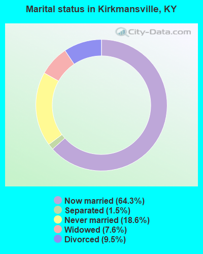
- Never married: 18.6%
- Now married: 64.3%
- Separated: 1.5%
- Widowed: 7.6%
- Divorced: 9.5%
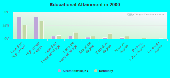
For population 25 years and over in Kirkmansville:
- High school or higher: 58.6%
- Bachelor's degree or higher: 4.8%
- Graduate or professional degree: 2.2%
- Unemployed: 3.3%
- Mean travel time to work (commute): 25.0 minutes
| Here: | 15.4 |
| Kentucky average: | 13.8 |
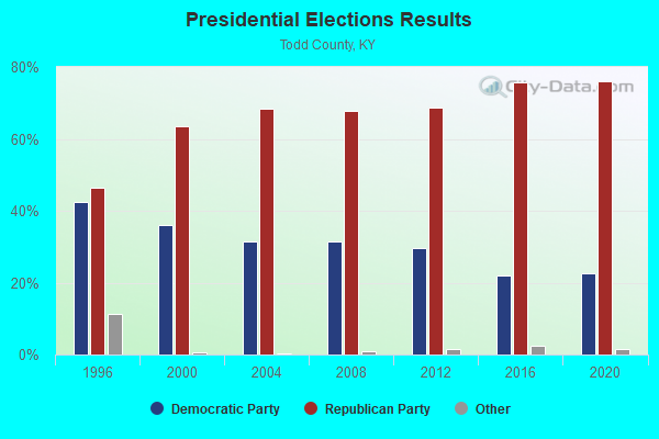
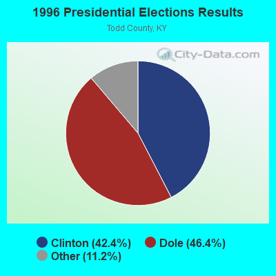
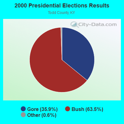
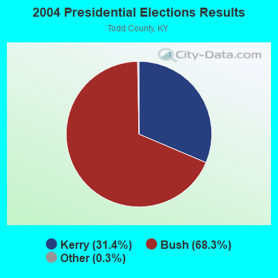

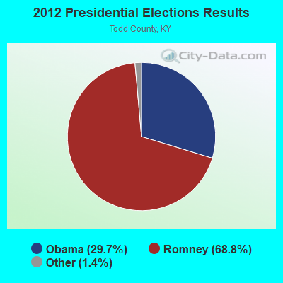
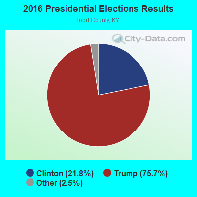
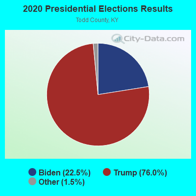
Graphs represent county-level data. Detailed 2008 Election Results
Religion statistics for Kirkmansville, KY (based on Todd County data)
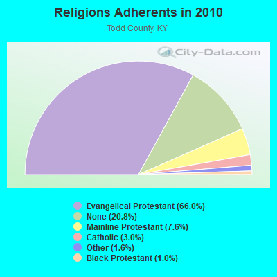
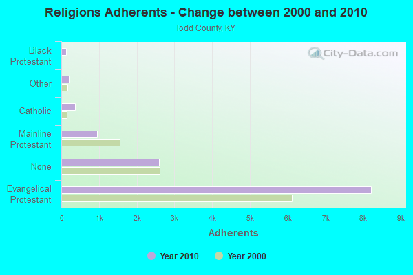
| Religion | Adherents | Congregations |
|---|---|---|
| Evangelical Protestant | 8,221 | 35 |
| Mainline Protestant | 947 | 15 |
| Catholic | 373 | 2 |
| Other | 198 | 1 |
| Black Protestant | 128 | 1 |
| None | 2,593 | - |
Food Environment Statistics:
| Todd County: | 2.50 / 10,000 pop. |
| State: | 2.19 / 10,000 pop. |
| Here: | 0.83 / 10,000 pop. |
| Kentucky: | 0.74 / 10,000 pop. |
| Todd County: | 5.82 / 10,000 pop. |
| Kentucky: | 4.36 / 10,000 pop. |
| Here: | 4.99 / 10,000 pop. |
| Kentucky: | 5.74 / 10,000 pop. |
| Todd County: | 10.3% |
| Kentucky: | 11.0% |
| This county: | 30.6% |
| Kentucky: | 30.0% |
| This county: | 15.4% |
| Kentucky: | 15.9% |
Strongest AM radio stations in Kirkmansville:
- WSM (650 AM; 50 kW; NASHVILLE, TN; Owner: GAYLORD ENTERTAINMENT COMPANY)
- WKDA (1200 AM; 50 kW; NASHVILLE, TN; Owner: RADIO NASHVILLE, INC.)
- WNQM (1300 AM; 50 kW; NASHVILLE, TN; Owner: WNQM. INC.)
- WLAC (1510 AM; 50 kW; NASHVILLE, TN; Owner: CAPSTAR TX LIMITED PARTNERSHIP)
- WAMB (1160 AM; 50 kW; DONELSON, TN; Owner: GREAT SOUTHERN BROADCASTING COMPANY, INC.)
- WRUS (610 AM; 2 kW; RUSSELLVILLE, KY; Owner: LOGAN RADIO INCORPORATED)
- WPLN (1430 AM; 15 kW; MADISON, TN)
- WEKT (1070 AM; 0 kW; ELKTON, KY; Owner: M & R BROADCASTING, INC.)
- WHAS (840 AM; 50 kW; LOUISVILLE, KY; Owner: CLEAR CHANNEL BROADCASTING LICENSES, INC.)
- WKCT (930 AM; 5 kW; BOWLING GREEN, KY; Owner: DAILY NEWS BROADCASTING CO.)
- WWAM (820 AM; daytime; 50 kW; JASPER, TN; Owner: SHELTON BROADCASTING SYSTEM)
- WNES (1050 AM; 1 kW; CENTRAL CITY, KY; Owner: STARLIGHT BROADCASTING CO., INC.)
- WHOP (1230 AM; 1 kW; HOPKINSVILLE, KY; Owner: HOP BROADCASTING, INC.)
Strongest FM radio stations in Kirkmansville:
- WQXQ (101.9 FM; CENTRAL CITY, KY; Owner: STARLIGHT BROADCASTING CO., INC.)
- WUBT (101.1 FM; RUSSELLVILLE, KY; Owner: CAPSTAR TX LIMITED PARTNERSHIP)
- WVVR (100.3 FM; HOPKINSVILLE, KY; Owner: SAGA COMMUNICATIONS OF TUCKESSEE, LLC)
- WNTC (103.9 FM; DRAKESBORO, KY; Owner: NASHVILLE'S SPORTSRADIO, INCORPORATED)
- WKYA (105.5 FM; GREENVILLE, KY; Owner: STARLIGHT BROADCASTING CO., INC.)
- WNKJ (89.3 FM; HOPKINSVILLE, KY; Owner: PENNYRILE CHRISTIAN COMMUNITY, INC.)
- WBKR (92.5 FM; OWENSBORO, KY; Owner: REGENT BROADCASTING OF EVANSVILLE/OWENSBORO, INC.)
- WCVQ (107.9 FM; FORT CAMPBELL, KY; Owner: SAGA COMMUNICATIONS OF TUCKESSEE, LLC)
- WKYU-FM (88.9 FM; BOWLING GREEN, KY; Owner: WESTERN KENTUCKY UNIVERSITY)
- WKTG (93.9 FM; MADISONVILLE, KY; Owner: SOUND BROADCASTERS, INC.)
- WZZP (97.5 FM; HOPKINSVILLE, KY; Owner: SAGA COMMUNICATIONS OF TUCKESSEE, LLC)
- WHOP-FM (98.7 FM; HOPKINSVILLE, KY; Owner: HOP BROADCASTING, INC.)
- WYMV (106.9 FM; MADISONVILLE, KY; Owner: MADISONVILLE CBC, INC.)
TV broadcast stations around Kirkmansville:
- WKMA-TV (Channel 35; MADISONVILLE, KY; Owner: KENTUCKY AUTHORITY FOR EDUCATIONAL TV)
- W62CJ (Channel 62; JACKSON, TN; Owner: MS COMMUNICATIONS, LLC)
- WAZE-TV (Channel 19; MADISONVILLE, KY; Owner: SOUTH CENTRAL COMMUNICATIONS CORP.)
- WKGB-TV (Channel 53; BOWLING GREEN, KY; Owner: KENTUCKY AUTHORITY FOR EDUCATIONAL TV)
- WKAG-CA (Channel 43; HOPKINSVILLE, KY; Owner: KENTUCKY NEW ERA, INC.)
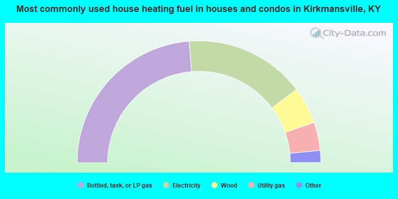
- 47.4%Bottled, tank, or LP gas
- 32.1%Electricity
- 9.8%Wood
- 7.5%Utility gas
- 1.5%Coal or coke
- 1.2%Fuel oil, kerosene, etc.
- 0.5%No fuel used
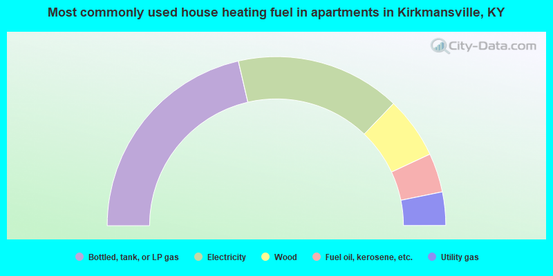
- 42.8%Bottled, tank, or LP gas
- 31.6%Electricity
- 11.8%Wood
- 7.5%Fuel oil, kerosene, etc.
- 6.4%Utility gas
Kirkmansville compared to Kentucky state average:
- Median house value below state average.
- Unemployed percentage significantly below state average.
- Black race population percentage significantly below state average.
- Hispanic race population percentage significantly below state average.
- Median age below state average.
- Foreign-born population percentage significantly below state average.
- Renting percentage below state average.
- Length of stay since moving in significantly above state average.
- Number of rooms per house significantly below state average.
- House age significantly below state average.
- Percentage of population with a bachelor's degree or higher significantly below state average.