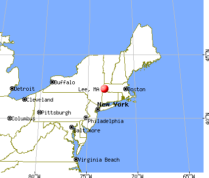
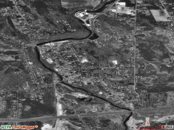
Lee, Massachusetts

Lee: Evening fisherman coming into boat ramp at Laurel lake, Lee, MAss.

Lee: sunrise on Golden Hill..Lee, Mass.

Lee: Mountain's view

Lee: Early September morning at Laurel Lake
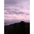
Lee: Mountain's view

Lee: double rainbow on Golden Hill, Lee, Ma.
- add
your
Submit your own pictures of this place and show them to the world
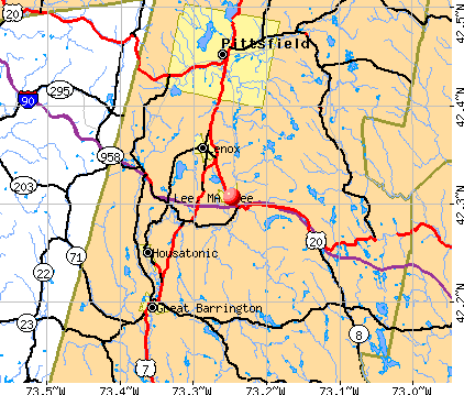
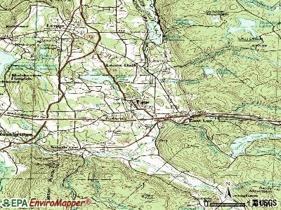
- OSM Map
- General Map
- Google Map
- MSN Map
Population change since 2000: +1.5%
| Males: 1,137 | |
| Females: 914 |
| Median resident age: | 52.0 years |
| Massachusetts median age: | 40.3 years |
Zip codes: 01238.
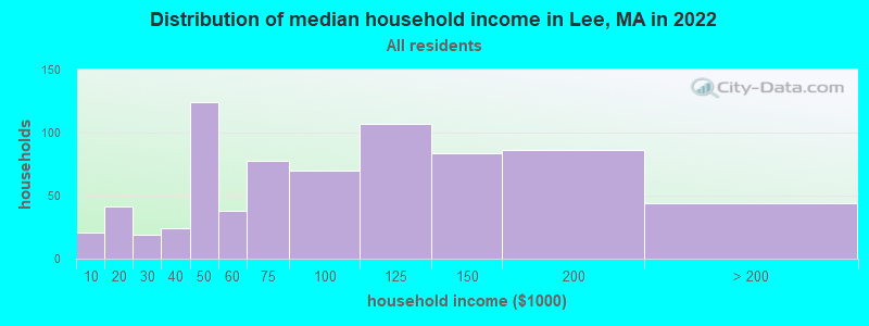
| Lee: | $82,979 |
| MA: | $94,488 |
Estimated per capita income in 2022: $49,816 (it was $18,069 in 2000)
Lee CDP income, earnings, and wages data
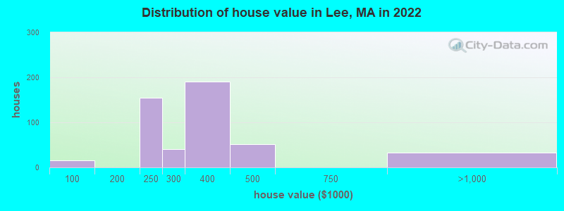
Estimated median house or condo value in 2022: $304,218 (it was $120,800 in 2000)
| Lee: | $304,218 |
| MA: | $534,700 |
Mean prices in 2022: all housing units: $339,815; detached houses: $340,996
Median gross rent in 2022: $1,151.
(3.7% for White Non-Hispanic residents, 100.0% for Black residents)
Detailed information about poverty and poor residents in Lee, MA
Compare current foreclosures near Lee, MA:
| Photo | Address | Area | Beds / Baths | Price | Details |
|---|---|---|---|---|---|

|
#1
Washington Mountain Rd
Lee, MA 01238
|
- sq. feet
|
1 baths 3 beds |
$155,000
|
show details |

|
#2
East St
Lee, MA 01238
|
1,478 sq. feet
|
2 baths 3 beds |
show details | |

|
#3
Chapel St
Lee, MA 01238
|
1,584 sq. feet
|
1 baths 3 beds |
show details | |

|
#4
High St Apt 1
Lee, MA 01238
|
- sq. feet
|
- baths - beds |
show details | |

|
#5
Crystal St
Lenox Dale, MA 01242
|
1,918 sq. feet
|
2 baths 3 beds |
$165,900
|
show details |

|
#6
North St
Pittsfield, MA 01201
|
1,661 sq. feet
|
2 baths 4 beds |
show details | |

|
#7
Tierney Pl
Pittsfield, MA 01201
|
1,103 sq. feet
|
1 baths 3 beds |
show details | |

|
#8
Madison Ave
Pittsfield, MA 01201
|
2,192 sq. feet
|
2 baths 6 beds |
show details | |

|
#9
Robbins Ave
Pittsfield, MA 01201
|
1,872 sq. feet
|
2 baths 4 beds |
show details | |

|
#10
Daniels Ave
Pittsfield, MA 01201
|
3,040 sq. feet
|
3 baths 6 beds |
show details |
| Photo | Address | Area | Beds / Baths | Price | Details |
|---|---|---|---|---|---|

|
#11
Circular Ave
Pittsfield, MA 01201
|
2,808 sq. feet
|
4 baths 8 beds |
show details | |

|
#12
Weller Ave
Pittsfield, MA 01201
|
3,376 sq. feet
|
3 baths 6 beds |
show details | |

|
#13
Wilshire Dr
Cheshire, MA 01225
|
4,302 sq. feet
|
2 baths 3 beds |
show details | |

|
#14
Middlefield Rd
Chester, MA 01011
|
1,760 sq. feet
|
2 baths 3 beds |
show details | |

|
#15
David Dr
Hinsdale, MA 01235
|
1,664 sq. feet
|
2 baths 3 beds |
show details | |

|
#16
Briggs Ave
Pittsfield, MA 01201
|
2,116 sq. feet
|
2 baths 4 beds |
show details | |

|
#17
Old North Rd
Worthington, MA 01098
|
2,369 sq. feet
|
3 baths 4 beds |
show details | |

|
#18
S Sandisfield Rd
Great Barrington, MA 01230
|
1,983 sq. feet
|
2 baths 2 beds |
show details | |

|
#19
S Undermountain Rd
Sheffield, MA 01257
|
1,713 sq. feet
|
2 baths 3 beds |
show details | |

|
#20
Lenox Ave
Pittsfield, MA 01201
|
2,290 sq. feet
|
2 baths 6 beds |
show details |
| Photo | Address | Area | Beds / Baths | Price | Details |
|---|---|---|---|---|---|

|
#21
Lenox Ave
Pittsfield, MA 01201
|
1,376 sq. feet
|
1 baths 3 beds |
show details | |

|
#22
Blair Rd
Blandford, MA 01008
|
1,580 sq. feet
|
1 baths 3 beds |
show details | |

|
#23
Mcarthur St
Pittsfield, MA 01201
|
1,155 sq. feet
|
1 baths 2 beds |
show details | |

|
#24
North St
Dalton, MA 01226
|
1,852 sq. feet
|
2 baths 4 beds |
show details | |

|
#25
Main St
Sheffield, MA 01257
|
3,683 sq. feet
|
5 baths 6 beds |
show details | |

|
#26
Davis St
Pittsfield, MA 01201
|
1,456 sq. feet
|
2 baths 3 beds |
show details | |

|
#27
Ashuelot St
Dalton, MA 01226
|
1,792 sq. feet
|
2 baths 3 beds |
show details | |

|
#28
Hancock Rd
Pittsfield, MA 01201
|
1,344 sq. feet
|
2 baths 3 beds |
show details | |

|
#29
Upper Queechy Rd
Canaan, NY 12029
|
912 sq. feet
|
1 baths 2 beds |
show details | |

|
#30
Elberon Ave
Pittsfield, MA 01201
|
1,794 sq. feet
|
1 baths 4 beds |
show details |
| Photo | Address | Area | Beds / Baths | Price | Details |
|---|---|---|---|---|---|

|
#31
Frisbee St
East Chatham, NY 12060
|
2,400 sq. feet
|
2 baths 4 beds |
show details | |

|
#32
Baker St
Lanesboro, MA 01237
|
1,231 sq. feet
|
1 baths 3 beds |
show details | |

|
#33
County Rd
Great Barrington, MA 01230
|
1,576 sq. feet
|
1 baths 4 beds |
show details | |

|
#34
Crystal St
Pittsfield, MA 01201
|
1,282 sq. feet
|
1 baths 3 beds |
show details | |

|
#35
West St
Pittsfield, MA 01201
|
2,018 sq. feet
|
1 baths 3 beds |
show details | |

|
#36
Main St
Becket, MA 01223
|
1,512 sq. feet
|
2 baths 2 beds |
show details | |

|
#37
Morgan St
Lenox, MA 01240
|
3,959 sq. feet
|
2 baths 3 beds |
show details | |

|
#38
Melville Ct
Lenox, MA 01240
|
3,988 sq. feet
|
6 baths 5 beds |
show details | |

|
#39
Jennifer St
Lenox, MA 01240
|
1,416 sq. feet
|
1 baths 3 beds |
show details | |

|
#40
Joseph Dr
Pittsfield, MA 01201
|
1,248 sq. feet
|
1 baths 3 beds |
show details |
| Photo | Address | Area | Beds / Baths | Price | Details |
|---|---|---|---|---|---|

|
#41
Anita Dr
Pittsfield, MA 01201
|
1,504 sq. feet
|
2 baths 3 beds |
show details | |

|
#42
S Washington State Rd
Becket, MA 01223
|
1,620 sq. feet
|
1 baths 2 beds |
show details | |

|
#43
Marshall Ave
Pittsfield, MA 01201
|
1,517 sq. feet
|
1 baths 3 beds |
show details | |

|
#44
Williams St
Pittsfield, MA 01201
|
1,245 sq. feet
|
1 baths 3 beds |
show details | |

|
#45
Donovan St
Pittsfield, MA 01201
|
1,652 sq. feet
|
2 baths 3 beds |
show details | |

|
#46
Kathy Way
Pittsfield, MA 01201
|
2,136 sq. feet
|
2 baths 3 beds |
show details | |

|
#47
Route 23
Hillsdale, NY 12529
|
2,762 sq. feet
|
2 baths 4 beds |
show details | |

|
#48
Longfellow Ave
Pittsfield, MA 01201
|
1,356 sq. feet
|
1 baths 4 beds |
show details | |

|
#49
Summit Ave
Pittsfield, MA 01201
|
1,664 sq. feet
|
2 baths 4 beds |
show details | |

|
Check over 1 million property listings on Foreclosure.com!
|
browse all offers | |||


- 1,29186.3%White alone
- 865.7%Asian alone
- 382.5%Black alone
- 302.0%Hispanic
- 251.7%Two or more races
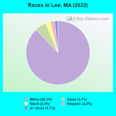
Races in Lee detailed stats: ancestries, foreign born residents, place of birth
According to our research of Massachusetts and other state lists, there were 4 registered sex offenders living in Lee, Massachusetts as of May 20, 2024.
The ratio of all residents to sex offenders in Lee is 457 to 1.
Type |
2009 |
2010 |
2011 |
2012 |
2013 |
2014 |
2015 |
2016 |
2017 |
2018 |
2019 |
2020 |
2021 |
2022 |
|---|---|---|---|---|---|---|---|---|---|---|---|---|---|---|
| Murders (per 100,000) | 0 (0.0) | 0 (0.0) | 0 (0.0) | 0 (0.0) | 0 (0.0) | 0 (0.0) | 0 (0.0) | 0 (0.0) | 0 (0.0) | 0 (0.0) | 0 (0.0) | 0 (0.0) | 0 (0.0) | 0 (0.0) |
| Rapes (per 100,000) | 0 (0.0) | 0 (0.0) | 2 (33.5) | 4 (67.1) | 3 (51.0) | 1 (16.9) | 4 (68.5) | 3 (51.8) | 1 (17.4) | 2 (35.1) | 3 (52.8) | 2 (35.5) | 1 (17.9) | 3 (52.3) |
| Robberies (per 100,000) | 1 (17.1) | 0 (0.0) | 0 (0.0) | 1 (16.8) | 0 (0.0) | 1 (16.9) | 0 (0.0) | 0 (0.0) | 0 (0.0) | 2 (35.1) | 0 (0.0) | 0 (0.0) | 1 (17.9) | 0 (0.0) |
| Assaults (per 100,000) | 6 (102.7) | 6 (101.0) | 8 (133.8) | 10 (167.8) | 4 (68.0) | 6 (101.5) | 13 (222.6) | 10 (172.7) | 7 (121.8) | 13 (228.3) | 7 (123.1) | 11 (195.3) | 5 (89.3) | 8 (139.4) |
| Burglaries (per 100,000) | 29 (496.3) | 27 (454.3) | 34 (568.7) | 39 (654.4) | 23 (391.0) | 13 (219.8) | 8 (137.0) | 18 (310.9) | 16 (278.3) | 15 (263.4) | 5 (87.9) | 10 (177.5) | 15 (268.0) | 13 (226.5) |
| Thefts (per 100,000) | 82 (1,403) | 106 (1,784) | 90 (1,505) | 89 (1,493) | 72 (1,224) | 62 (1,048) | 64 (1,096) | 81 (1,399) | 85 (1,479) | 67 (1,177) | 58 (1,020) | 49 (869.9) | 57 (1,018) | 70 (1,220) |
| Auto thefts (per 100,000) | 3 (51.3) | 2 (33.7) | 3 (50.2) | 1 (16.8) | 3 (51.0) | 0 (0.0) | 4 (68.5) | 3 (51.8) | 4 (69.6) | 1 (17.6) | 2 (35.2) | 2 (35.5) | 2 (35.7) | 3 (52.3) |
| Arson (per 100,000) | 0 (0.0) | 0 (0.0) | 0 (0.0) | 1 (16.8) | 0 (0.0) | 0 (0.0) | 0 (0.0) | 0 (0.0) | 0 (0.0) | 0 (0.0) | 0 (0.0) | 0 (0.0) | 0 (0.0) | 0 (0.0) |
| City-Data.com crime index | 120.7 | 126.0 | 157.6 | 199.2 | 134.8 | 96.2 | 158.2 | 157.9 | 122.5 | 151.2 | 116.6 | 117.5 | 99.9 | 138.5 |
The City-Data.com crime index weighs serious crimes and violent crimes more heavily. Higher means more crime, U.S. average is 246.1. It adjusts for the number of visitors and daily workers commuting into cities.
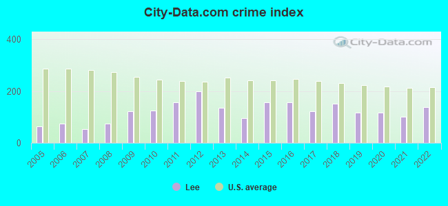
Crime rate in Lee detailed stats: murders, rapes, robberies, assaults, burglaries, thefts, arson
Full-time law enforcement employees in 2015, including police officers: 12 (11 officers - 10 male; 1 female).
| Officers per 1,000 residents here: | 1.88 |
| Massachusetts average: | 2.54 |
 Recent articles from our blog. Our writers, many of them Ph.D. graduates or candidates, create easy-to-read articles on a wide variety of topics.

 | Boston crime thread - all posts go here. (2497 replies) |
| Photos of MA-please limit to photos & their discussion only, thanks. (670 replies) |
| What Pittsfield area like ? (44 replies) |
| 1 day trip across MA - what route for iconic scenery? (43 replies) |
| And then there were two... (758 replies) |
| Best Yankees Bar in Massachusetts (2022 Update)? (49 replies) |
Latest news from Lee, MA collected exclusively by city-data.com from local newspapers, TV, and radio stations
Lee, MA City Guides:
Ancestries: Italian (31.8%), Irish (7.7%), Scandinavian (7.1%), American (6.5%), Cape Verdean (6.2%), Lebanese (6.0%).
Current Local Time: EST time zone
Incorporated in 1777
Elevation: 1000 feet
Land area: 1.36 square miles.
Population density: 1,504 people per square mile (low).
175 residents are foreign born (8.5% Asia, 2.8% Europe).
| This place: | 11.7% |
| Massachusetts: | 17.6% |
Median real estate property taxes paid for housing units with mortgages in 2022: $3,178 (1.1%)
Median real estate property taxes paid for housing units with no mortgage in 2022: $3,930 (1.1%)
Nearest city with pop. 50,000+: Chicopee, MA  (35.0 miles , pop. 54,653).
Nearest city with pop. 200,000+: Bronx, NY (106.1 miles , pop. 1,332,650).
Nearest cities:
), ), ), ), ), )Latitude: 42.31 N, Longitude: 73.25 W
Area code: 413
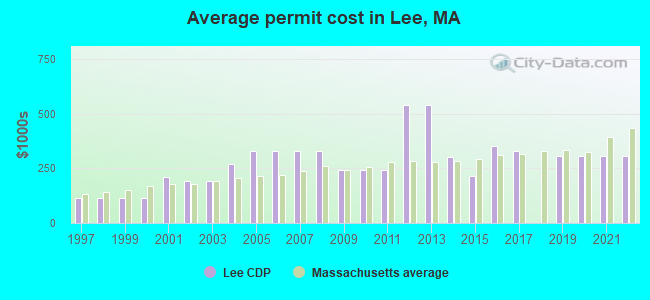
Single-family new house construction building permits:
- 2022: 8 buildings, average cost: $308,300
- 2021: 6 buildings, average cost: $308,300
- 2020: 5 buildings, average cost: $308,300
- 2019: 4 buildings, average cost: $308,300
- 2017: 6 buildings, average cost: $328,700
- 2016: 9 buildings, average cost: $351,500
- 2015: 4 buildings, average cost: $214,900
- 2014: 10 buildings, average cost: $300,600
- 2013: 2 buildings, average cost: $540,000
- 2012: 2 buildings, average cost: $540,000
- 2011: 4 buildings, average cost: $240,600
- 2010: 6 buildings, average cost: $240,600
- 2009: 7 buildings, average cost: $240,600
- 2008: 11 buildings, average cost: $328,000
- 2007: 15 buildings, average cost: $328,000
- 2006: 18 buildings, average cost: $328,000
- 2005: 21 buildings, average cost: $328,000
- 2004: 18 buildings, average cost: $271,200
- 2003: 19 buildings, average cost: $193,600
- 2002: 21 buildings, average cost: $190,800
- 2001: 8 buildings, average cost: $209,000
- 2000: 11 buildings, average cost: $115,600
- 1999: 11 buildings, average cost: $115,600
- 1998: 11 buildings, average cost: $115,600
- 1997: 11 buildings, average cost: $115,600

| Here: | 3.8% |
| Massachusetts: | 3.5% |
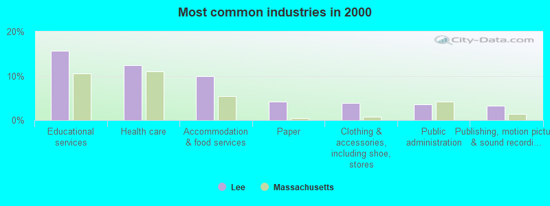
- Educational services (15.7%)
- Health care (12.4%)
- Accommodation & food services (10.0%)
- Paper (4.1%)
- Clothing & accessories, including shoe, stores (3.8%)
- Public administration (3.6%)
- Publishing, motion picture & sound recording industries (3.3%)
- Health care (9.1%)
- Accommodation & food services (8.9%)
- Paper (8.1%)
- Educational services (5.8%)
- Construction (5.2%)
- Clothing & accessories, including shoe, stores (4.8%)
- Finance & insurance (4.6%)
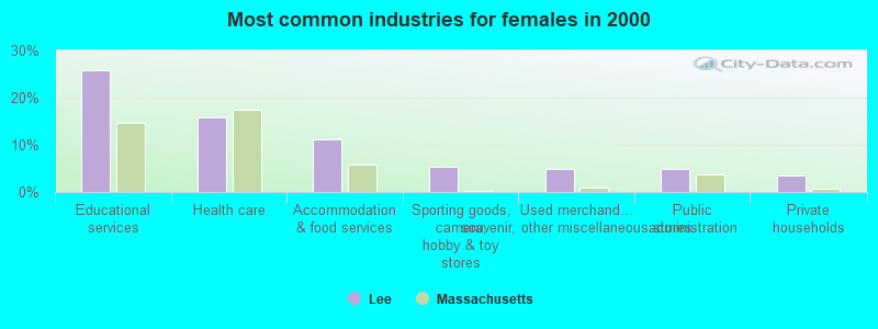
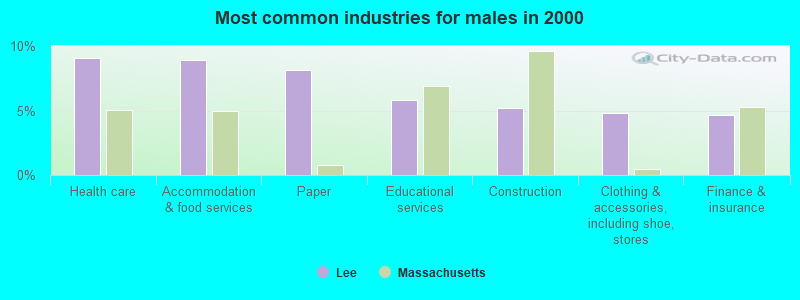
- Educational services (25.9%)
- Health care (15.7%)
- Accommodation & food services (11.2%)
- Sporting goods, camera, hobby & toy stores (5.4%)
- Used merchandise, gift, novelty, souvenir, other miscellaneous stores (5.0%)
- Public administration (4.8%)
- Private households (3.6%)
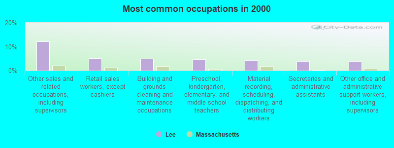
- Other sales and related occupations, including supervisors (12.2%)
- Retail sales workers, except cashiers (5.1%)
- Building and grounds cleaning and maintenance occupations (5.0%)
- Preschool, kindergarten, elementary, and middle school teachers (4.8%)
- Material recording, scheduling, dispatching, and distributing workers (4.4%)
- Secretaries and administrative assistants (4.0%)
- Other office and administrative support workers, including supervisors (4.0%)
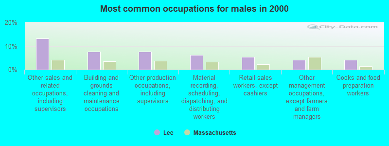
- Other sales and related occupations, including supervisors (13.1%)
- Building and grounds cleaning and maintenance occupations (7.5%)
- Other production occupations, including supervisors (7.5%)
- Material recording, scheduling, dispatching, and distributing workers (6.2%)
- Retail sales workers, except cashiers (5.4%)
- Other management occupations, except farmers and farm managers (4.1%)
- Cooks and food preparation workers (4.1%)

- Other sales and related occupations, including supervisors (11.2%)
- Secretaries and administrative assistants (8.2%)
- Preschool, kindergarten, elementary, and middle school teachers (7.4%)
- Information and record clerks, except customer service representatives (6.4%)
- Other office and administrative support workers, including supervisors (5.0%)
- Retail sales workers, except cashiers (4.8%)
- Customer service representatives (4.6%)
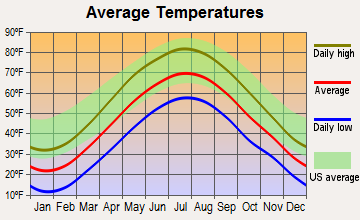
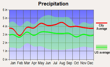
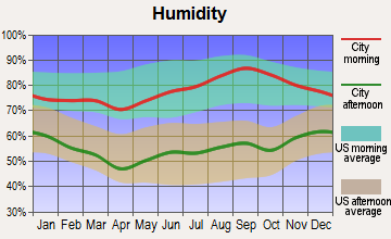
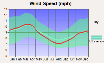
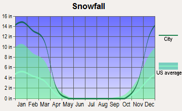
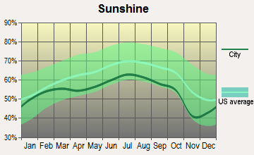
Average climate in Lee, Massachusetts
Based on data reported by over 4,000 weather stations
|
|


(lower is better)
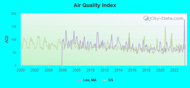
Air Quality Index (AQI) level in 2022 was 63.2. This is about average.
| City: | 63.2 |
| U.S.: | 72.6 |
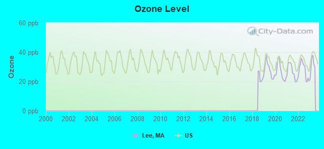
Ozone [ppb] level in 2022 was 27.5. This is better than average. Closest monitor was 9.7 miles away from the city center.
| City: | 27.5 |
| U.S.: | 33.3 |
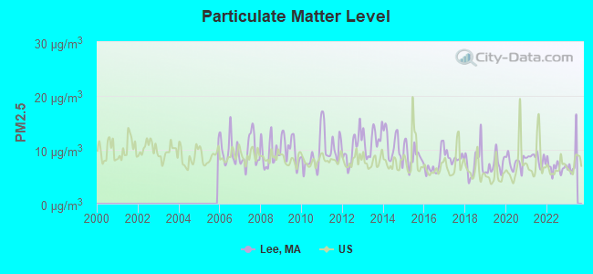
Particulate Matter (PM2.5) [µg/m3] level in 2022 was 6.76. This is about average. Closest monitor was 9.8 miles away from the city center.
| City: | 6.76 |
| U.S.: | 8.11 |
Tornado activity:
Lee-area historical tornado activity is slightly above Massachusetts state average. It is 17% smaller than the overall U.S. average.
On 8/28/1973, a category F4 (max. wind speeds 207-260 mph) tornado 7.3 miles away from the Lee place center killed 4 people and injured 36 people and caused between $5,000,000 and $50,000,000 in damages.
On 5/29/1995, a category F4 tornado 10.3 miles away from the place center killed 3 people and injured 24 people and caused between $5,000,000 and $50,000,000 in damages.
Earthquake activity:
Lee-area historical earthquake activity is significantly above Massachusetts state average. It is 69% smaller than the overall U.S. average.On 10/7/1983 at 10:18:46, a magnitude 5.3 (5.1 MB, 5.3 LG, 5.1 ML, Class: Moderate, Intensity: VI - VII) earthquake occurred 126.6 miles away from the city center
On 4/20/2002 at 10:50:47, a magnitude 5.3 (5.3 ML, Depth: 3.0 mi) earthquake occurred 154.2 miles away from the city center
On 4/20/2002 at 10:50:47, a magnitude 5.2 (5.2 MB, 4.2 MS, 5.2 MW, 5.0 MW) earthquake occurred 152.6 miles away from the city center
On 1/19/1982 at 00:14:42, a magnitude 4.7 (4.5 MB, 4.7 MD, 4.5 LG, Class: Light, Intensity: IV - V) earthquake occurred 117.4 miles away from Lee center
On 10/16/2012 at 23:12:25, a magnitude 4.7 (4.7 ML, Depth: 10.0 mi) earthquake occurred 158.7 miles away from Lee center
On 8/23/2011 at 17:51:04, a magnitude 5.8 (5.8 MW, Depth: 3.7 mi) earthquake occurred 392.3 miles away from the city center
Magnitude types: regional Lg-wave magnitude (LG), body-wave magnitude (MB), duration magnitude (MD), local magnitude (ML), surface-wave magnitude (MS), moment magnitude (MW)
Natural disasters:
The number of natural disasters in Berkshire County (21) is greater than the US average (15).Major Disasters (Presidential) Declared: 10
Emergencies Declared: 10
Causes of natural disasters: Floods: 5, Snowstorms: 5, Storms: 5, Hurricanes: 4, Winter Storms: 4, Blizzards: 2, Snows: 2, Snowfall: 1, Tropical Storm: 1, Wind: 1, Other: 1 (Note: some incidents may be assigned to more than one category).
Main business address for: WAVE SYSTEMS CORP (COMPUTER PERIPHERAL EQUIPMENT, NEC).
Hospitals and medical centers in Lee:
- LEE REGIONAL VNA INC. (21 HIGH STREET)
- KINDRED NURSING AND REHABILITATION-LAUREL LAKE (620 LAUREL STREET)
Other hospitals and medical centers near Lee:
- NURSING CARE CENTER AT KIMBALL (Nursing Home, about 4 miles away; LENOX, MA)
- EDGECOMBE NURSING HOME (Nursing Home, about 5 miles away; LENOX, MA)
- KIMBALL FARMS NURSING CARE CENTER (Nursing Home, about 5 miles away; LENOX, MA)
- PROVIDENCE CARE CENTER - LENOX (Nursing Home, about 7 miles away; LENOX, MA)
- VALLEY VIEW NURSING HOME (Nursing Home, about 7 miles away; LENOX, MA)
- HOSPICE OF THE BERKSHIRES, INC (Hospital, about 10 miles away; PITTSFIELD, MA)
- SPRINGSIDE REHABILITATION AND SKILLED CARE CENTER (Nursing Home, about 10 miles away; PITTSFIELD, MA)
Colleges/universities with over 2000 students nearest to Lee:
- Westfield State University (about 27 miles; Westfield, MA; Full-time enrollment: 5,548)
- Williams College (about 29 miles; Williamstown, MA; FT enrollment: 2,141)
- Smith College (about 32 miles; Northampton, MA; FT enrollment: 3,549)
- Holyoke Community College (about 32 miles; Holyoke, MA; FT enrollment: 4,911)
- Mount Holyoke College (about 35 miles; South Hadley, MA; FT enrollment: 2,573)
- Hudson Valley Community College (about 35 miles; Troy, NY; FT enrollment: 9,346)
- Rensselaer Polytechnic Institute (about 37 miles; Troy, NY; FT enrollment: 6,940)
Public elementary/middle school in Lee:
- LEE ELEMENTARY (Students: 397, Location: 310 GREYLOCK STREET, Grades: PK-6)
Private elementary/middle school in Lee:
Points of interest:
Notable locations in Lee: Greenover Country Club (A), Greenock Country Club (B), Lee Ambulance Service (C), Lee Fire Department Station 1 Headquarters (D), Lee Library Association (E), Lee Town Hall (F). Display/hide their locations on the map
Churches in Lee include: Greater Grace Church (A), Saint Georges Episcopal Church (B). Display/hide their locations on the map
Cemetery: Saint Marys Cemetery (1). Display/hide its location on the map
Tourist attraction: Animagic Museum of Animation Special Effects & Art (77 Main Street).
Hotels: Applegate Inn (279 West Park Street), Best Western Black Swan Inn (435 Laurel Street), Cygnets Restaurant at the Black Swan Inn (Laurel Lake), Lee Super 8 Motel (170 Housatonic St), Lee Motor Inn (Pleasant), Laurel Hill Motel (200 Laurel Street), Pilgrim Inn (165 Housatonic Street).
Birthplace of: Henry Billings Brown - Judge, Thomas C. Durant - Railroad executive, Charlie Hackett - Baseball manager, Edward V. Whiton - Member of the Wisconsin Territorial Legislature and Supreme court, Frank Dwyer - Baseball player, Henri Gosselin - Politician, Tim Collins - College basketball player (Massachusetts Minutemen), William C. Moulton - Politician.
Drinking water stations with addresses in Lee and their reported violations in the past:
LEE WATER DEPT (Population served: 5,284, Surface water):Past health violations:HIGH LAWN FARM (Population served: 25, Groundwater):Past monitoring violations:
- MCL, Monthly (TCR) - In APR-2013, Contaminant: Coliform. Follow-up actions: St AO (w/o penalty) issued (MAY-17-2013)
- Follow-up Or Routine LCR Tap M/R - In OCT-01-2005, Contaminant: Lead and Copper Rule. Follow-up actions: St Compliance achieved (OCT-11-2005), St AO (w/o penalty) issued (DEC-29-2005)
- 38 regular monitoring violations
Past monitoring violations:
- One regular monitoring violation
| This place: | 2.2 people |
| Massachusetts: | 2.5 people |
| This place: | 53.3% |
| Whole state: | 63.0% |
| This place: | 7.3% |
| Whole state: | 7.0% |
Likely homosexual households (counted as self-reported same-sex unmarried-partner households)
- Lesbian couples: 0.4% of all households
- Gay men: 0.2% of all households
People in group quarters in Lee in 2010:
- 44 people in residential schools for people with disabilities
- 20 people in residential treatment centers for juveniles (non-correctional)
- 8 people in group homes intended for adults
- 4 people in college/university student housing
8 people in wards in general hospitals for patients who have no usual home elsewhere in 2000
Banks with branches in Lee (2011 data):
- Berkshire Bank: Lee Branch at 1 Park Street, branch established on 1972/06/12; Night Deposit Facility at 50 Water Street, branch established on 1997/07/10. Info updated 2011/08/24: Bank assets: $3,955.6 mil, Deposits: $3,176.2 mil, headquarters in Pittsfield, MA, positive income, Commercial Lending Specialization, 64 total offices
- TrustCo Bank: Lee Branch at 43park St, branch established on 2007/04/16. Info updated 2011/07/21: Bank assets: $4,250.1 mil, Deposits: $3,736.0 mil, headquarters in Glenville, NY, positive income, Mortgage Lending Specialization, 135 total offices
- Adams Community Bank: Lee Branch at 41 Park Street, branch established on 2007/10/22. Info updated 2012/03/02: Bank assets: $202.3 mil, Deposits: $163.5 mil, headquarters in Adams, MA, positive income, Mortgage Lending Specialization, 7 total offices
- Lee Bank: at 75 Park Street, branch established on 1992/07/01. Info updated 2006/11/03: Bank assets: $266.2 mil, Deposits: $181.6 mil, local headquarters, positive income, Commercial Lending Specialization, 3 total offices, Holding Company: Berkshire Financial Services, Inc.
- NBT Bank, National Association: 76 Park Street Branch at 76 Park Street, branch established on 1835/01/01. Info updated 2012/02/02: Bank assets: $5,558.5 mil, Deposits: $4,381.4 mil, headquarters in Norwich, NY, positive income, Commercial Lending Specialization, 133 total offices, Holding Company: Nbt Bancorp Inc.
For population 15 years and over in Lee:
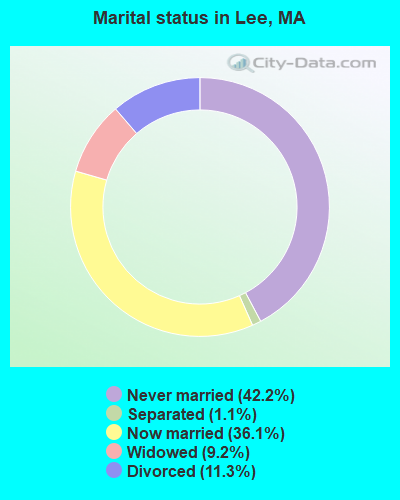
- Never married: 42.2%
- Now married: 36.1%
- Separated: 1.1%
- Widowed: 9.2%
- Divorced: 11.3%
For population 25 years and over in Lee:
- High school or higher: 96.5%
- Bachelor's degree or higher: 39.3%
- Graduate or professional degree: 22.3%
- Unemployed: 3.1%
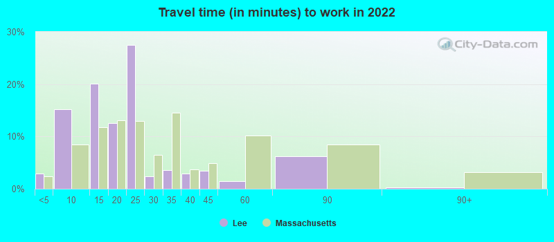
- Mean travel time to work (commute): 14.4 minutes

| Here: | 13.1 |
| Massachusetts average: | 13.0 |


Graphs represent county-level data. Detailed 2008 Election Results
Religion statistics for Lee, MA (based on Berkshire County data)


| Religion | Adherents | Congregations |
|---|---|---|
| Catholic | 50,187 | 32 |
| Mainline Protestant | 9,895 | 63 |
| Other | 3,647 | 20 |
| Evangelical Protestant | 2,817 | 28 |
| Black Protestant | 233 | 2 |
| Orthodox | 225 | 2 |
| None | 64,215 | - |
Food Environment Statistics:
| This county: | 2.54 / 10,000 pop. |
| State: | 1.98 / 10,000 pop. |
| This county: | 1.61 / 10,000 pop. |
| State: | 2.22 / 10,000 pop. |
| Here: | 4.08 / 10,000 pop. |
| Massachusetts: | 1.77 / 10,000 pop. |
| Berkshire County: | 15.00 / 10,000 pop. |
| Massachusetts: | 8.76 / 10,000 pop. |
| Berkshire County: | 8.0% |
| Massachusetts: | 8.1% |
| Berkshire County: | 22.8% |
| Massachusetts: | 22.5% |
| This county: | 9.9% |
| Massachusetts: | 16.5% |
Health and Nutrition:
| Lee: | 49.8% |
| Massachusetts: | 50.5% |
| This city: | 48.7% |
| Massachusetts: | 48.0% |
| Lee: | 29.4 |
| Massachusetts: | 28.4 |
| Lee: | 21.3% |
| Massachusetts: | 20.7% |
| This city: | 15.2% |
| Massachusetts: | 10.4% |
| Lee: | 6.9 |
| Massachusetts: | 6.8 |
| This city: | 41.1% |
| Massachusetts: | 33.4% |
| This city: | 55.3% |
| State: | 57.1% |
| Lee: | 79.1% |
| Massachusetts: | 79.2% |
More about Health and Nutrition of Lee, MA Residents
| Businesses in Lee, MA | ||||
| Name | Count | Name | Count | |
|---|---|---|---|---|
| Aeropostale | 1 | H&R Block | 1 | |
| American Eagle Outfitters | 1 | IZOD | 1 | |
| Ann Taylor | 1 | J.Crew | 1 | |
| Banana Republic | 1 | Jones New York | 1 | |
| Bath & Body Works | 1 | MasterBrand Cabinets | 4 | |
| Brooks Brothers | 1 | McDonald's | 3 | |
| Clarks | 1 | Nike | 1 | |
| Decora Cabinetry | 2 | Pac Sun | 1 | |
| DressBarn | 1 | Quality | 1 | |
| Dressbarn | 1 | Rite Aid | 1 | |
| Dunkin Donuts | 1 | Rodeway Inn | 1 | |
| Eddie Bauer | 1 | Rue21 | 1 | |
| Famous Footwear | 1 | Subway | 2 | |
| FedEx | 1 | Super 8 | 1 | |
| GNC | 1 | Talbots | 1 | |
| Gap | 1 | True Value | 2 | |
| Gymboree | 1 | |||
Strongest AM radio stations in Lee:
- WNNZ (640 AM; 50 kW; WESTFIELD, MA; Owner: CLEAR CHANNEL BROADCASTING LICENSES, INC.)
- WUHN (1110 AM; daytime; 5 kW; PITTSFIELD, MA; Owner: WEINER BROADCASTING, INC.)
- WSBS (860 AM; 3 kW; GREAT BARRINGTON, MA; Owner: BERKSHIRE BROADCASTING CO., INC.)
- WTIC (1080 AM; 50 kW; HARTFORD, CT; Owner: INFINITY RADIO OPERATIONS INC.)
- WGY (810 AM; 50 kW; SCHENECTADY, NY; Owner: CLEAR CHANNEL BROADCASTING LICENSES, INC.)
- WPTR (1540 AM; 50 kW; ALBANY, NY; Owner: KIMTRON, INC.)
- WCRN (830 AM; 50 kW; WORCESTER, MA; Owner: CARTER BROADCASTING CORPORATION)
- WHYN (560 AM; 5 kW; SPRINGFIELD, MA; Owner: CLEAR CHANNEL BROADCASTING LICENSES, INC.)
- WVNE (760 AM; daytime; 25 kW; LEICESTER, MA; Owner: BLOUNT MASSCOM, INC.)
- WBEC (1420 AM; 1 kW; PITTSFIELD, MA; Owner: GREAT NORTHERN RADIO, LLC)
- WBRK (1340 AM; 1 kW; PITTSFIELD, MA; Owner: WBRK, INC.)
- WROW (590 AM; 5 kW; ALBANY, NY; Owner: 6 JOHNSON ROAD LICENSES, INC.)
- WFAN (660 AM; 50 kW; NEW YORK, NY; Owner: INFINITY BROADCASTING OPERATIONS, INC.)
Strongest FM radio stations in Lee:
- WBEC-FM (105.5 FM; PITTSFIELD, MA; Owner: GREAT NORTHERN RADIO, LLC)
- WUPE (95.9 FM; PITTSFIELD, MA; Owner: WEINER BROADCASTING, INC.)
- WHVP (91.1 FM; HUDSON, NY; Owner: SOUND OF LIFE, INC.)
- WAMC-FM (90.3 FM; ALBANY, NY; Owner: WAMC)
- WAMQ (105.1 FM; GREAT BARRINGTON, MA; Owner: WAMC)
- WZEC (97.5 FM; HOOSICK FALLS, NY; Owner: GREAT NORTHERN RADIO, LLC)
- WEQX (102.7 FM; MANCHESTER, VT; Owner: NORTHSHIRE COMMUNICATIONS, INC.)
- WHYN-FM (93.1 FM; SPRINGFIELD, MA; Owner: CLEAR CHANNEL BROADCASTING LICENSES, INC.)
- WJAN (95.1 FM; SUNDERLAND, VT; Owner: 6 JOHNSON ROAD LICENSES, INC.)
- WRNX (100.9 FM; AMHERST, MA; Owner: WESTERN MASSACHUSETTS RADIO COMPANY)
- WAMK (90.9 FM; KINGSTON, NY; Owner: W A M C)
- WFGB (89.7 FM; KINGSTON, NY; Owner: SOUND OF LIFE, INC.)
- WVAY (100.7 FM; WILMINGTON, VT; Owner: GREAT NORTHERN RADIO, L.L.C.)
- WAQY (102.1 FM; SPRINGFIELD, MA; Owner: SAGA COMMUNICATIONS OF NEW ENGLAND, LLC)
- WRCH (100.5 FM; NEW BRITAIN, CT; Owner: INFINITY RADIO OPERATIONS INC.)
- WAJZ (96.3 FM; VOORHEESVILLE, NY; Owner: 6 JOHNSON ROAD LICENSES, INC.)
- WZMR (104.9 FM; ALTAMONT, NY; Owner: 6 JOHNSON ROAD LICENSES, INC.)
- WFCR (88.5 FM; AMHERST, MA; Owner: UNIVERSITY OF MASSACHUSETTS)
- WYJB (95.5 FM; ALBANY, NY; Owner: 6 JOHNSON ROAD LICENSES, INC.)
- WKZE-FM (98.1 FM; SALISBURY, CT; Owner: JOHNSON DEVELOPMENT, INC.)
TV broadcast stations around Lee:
- WTIC-TV (Channel 61; HARTFORD, CT; Owner: TRIBUNE TELEVISION COMPANY)
- W11BJ (Channel 11; HARTFORD, CT; Owner: COMMUNICATIONS SITE MANAGEMENT LLC)
- WTXX (Channel 20; WATERBURY, CT; Owner: WTXX INC.)
- WUVN (Channel 18; HARTFORD, CT; Owner: ENTRAVISION HOLDINGS, LLC)
- WVIT (Channel 30; NEW BRITAIN, CT; Owner: OUTLET BROADCASTING, INC)
- National Bridge Inventory (NBI) Statistics
- 65Number of bridges
- 489ft / 149mTotal length
- $103,832,000Total costs
- 561,829Total average daily traffic
- 103,645Total average daily truck traffic
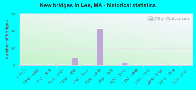
- New bridges - historical statistics
- 1Before 1900
- 11900-1909
- 11910-1919
- 11920-1929
- 91930-1939
- 11940-1949
- 431950-1959
- 31970-1979
- 11980-1989
- 11990-1999
- 12000-2009
- 12010-2019
- 12020-2022
FCC Registered Broadcast Land Mobile Towers:
12 (See the full list of FCC Registered Broadcast Land Mobile Towers in Lee, MA)FCC Registered Microwave Towers:
3- 5039, 335 Forest Street (Lat: 42.294000 Lon: -73.217722), Type: Pole, Structure height: 58.5 m, Call Sign: WPXE912,
Assigned Frequencies: 19305.0 MHz, Grant Date: 03/19/2003, Expiration Date: 03/19/2013, Cancellation Date: 12/27/2007, Certifier: Carol L Tacker, Registrant: Cingular Wireless LLC, 5601 Legacy Drive Ms A-3, Plano, TX 75024, Phone: (469) 229-7506, Fax: (469) 229-7295, Email:
- CT13XC236, 335 Forest Street (Lat: 42.294250 Lon: -73.217694), Type: Pole, Structure height: 57.9 m, Overall height: 59.1 m, Call Sign: WQPU421,
Assigned Frequencies: 11345.0 MHz, 11345.0 MHz, 11345.0 MHz, Grant Date: 08/16/2012, Expiration Date: 08/16/2022, Cancellation Date: 02/14/2014, Certifier: Kyle B Entz, Registrant: Sprint Nextel Corporation, 12502 Sunrise Valley Drive, Reston, VA 20196, Phone: (703) 433-4000, Fax: (703) 433-4483
- STATION, State Police Barracks Route 20 (Lat: 42.317028 Lon: -73.257583), Overall height: 30.5 m, Call Sign: KGU87,
Assigned Frequencies: 957.700 MHz, Grant Date: 10/30/2018, Expiration Date: 12/23/2028, Registrant: Massachusetts State Police, 470 Worchester Rd, Framingham, MA 01701, Phone: (508) 820-2222, Email:
FCC Registered Amateur Radio Licenses:
19 (See the full list of FCC Registered Amateur Radio Licenses in Lee)FAA Registered Aircraft Manufacturers and Dealers:
1- BERKSHIRE AIRCRAFT INC, 100 Mountain View Ter, Lee, MA 01238
Certificate: 01-1078 (Individual), Certificate Issue Date: 06/07/2001, Expiration Date: 06/06/2002
FAA Registered Aircraft:
3- Aircraft: BALLOON WORKS FIREFLY 7-15 (Category: Land, Weight: Up to 12,499 Pounds), Engine: None
N-Number: 155DW, N155DW, N-155DW, Serial Number: F71023, Year manufactured: 1997, Airworthiness Date: 08/05/1997, Certificate Issue Date: 12/09/2009
Registrant (Individual): Timothy O Taylor, 405 Devon Rd, Lee, MA 01238 - Aircraft: CESSNA 182Q (Category: Land, Seats: 4, Weight: Up to 12,499 Pounds, Speed: 112 mph), Engine: Reciprocating
N-Number: 735VB, N735VB, N-735VB, Serial Number: 18265709, Airworthiness Date: 05/16/1977, Certificate Issue Date: 03/09/2019
Registrant (Co-Owned): Louis M Iii Shogry, 20 East St, Lee, MA 01238, Other Owners: E Williams Paving Inc W - Aircraft: NORTH AMERICAN NAVION A (Category: Land, Seats: 5, Weight: Up to 12,499 Pounds, Speed: 126 mph), Engine: CONT MOTOR E185 SERIES (205 HP) (Reciprocating)
N-Number: 9190R, N9190R, N-9190R, Serial Number: NAV-4-1064, Year manufactured: 1947, Airworthiness Date: 07/13/1961, Certificate Issue Date: 04/12/2006
Registrant (Individual): David P Fraser, 80 Devon Rd, Lee, MA 01238
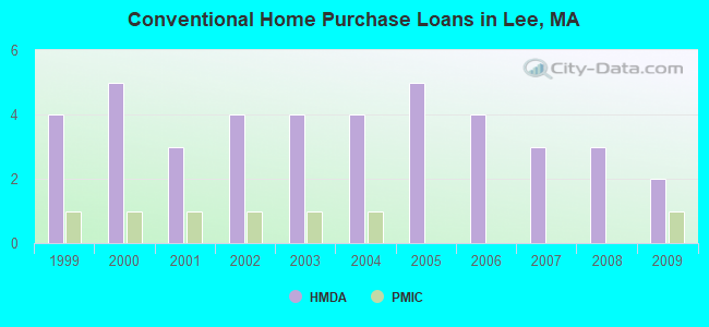
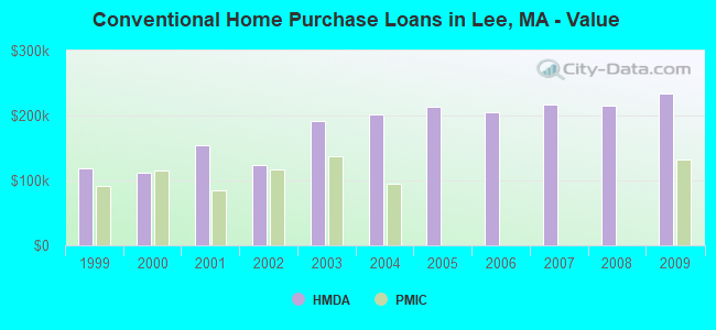
| Home Mortgage Disclosure Act Aggregated Statistics For Year 2009 (Based on 1 partial tract) | ||||||||
| B) Conventional Home Purchase Loans | C) Refinancings | D) Home Improvement Loans | F) Non-occupant Loans on < 5 Family Dwellings (A B C & D) | |||||
|---|---|---|---|---|---|---|---|---|
| Number | Average Value | Number | Average Value | Number | Average Value | Number | Average Value | |
| LOANS ORIGINATED | 2 | $233,945 | 9 | $191,757 | 1 | $192,080 | 2 | $199,370 |
| APPLICATIONS APPROVED, NOT ACCEPTED | 0 | $0 | 0 | $0 | 0 | $0 | 0 | $0 |
| APPLICATIONS DENIED | 0 | $0 | 2 | $194,470 | 0 | $0 | 0 | $0 |
| APPLICATIONS WITHDRAWN | 0 | $0 | 2 | $160,575 | 0 | $0 | 0 | $0 |
| FILES CLOSED FOR INCOMPLETENESS | 0 | $0 | 0 | $0 | 0 | $0 | 0 | $0 |
Detailed HMDA statistics for the following Tracts: 9141.00
| Private Mortgage Insurance Companies Aggregated Statistics For Year 2009 (Based on 1 partial tract) | ||
| A) Conventional Home Purchase Loans | ||
|---|---|---|
| Number | Average Value | |
| LOANS ORIGINATED | 1 | $132,830 |
| APPLICATIONS APPROVED, NOT ACCEPTED | 0 | $0 |
| APPLICATIONS DENIED | 0 | $0 |
| APPLICATIONS WITHDRAWN | 0 | $0 |
| FILES CLOSED FOR INCOMPLETENESS | 0 | $0 |
Detailed PMIC statistics for the following Tracts: 9141.00
2002 - 2018 National Fire Incident Reporting System (NFIRS) incidents
- Fire incident types reported to NFIRS in Lee, MA
- 8156.2%Structure Fires
- 4329.9%Mobile Property/Vehicle Fires
- 1913.2%Outside Fires
- 10.7%Other
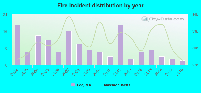 Based on the data from the years 2002 - 2018 the average number of fires per year is 8. The highest number of fire incidents - 19 took place in 2002, and the least - 2 in 2018. The data has a dropping trend.
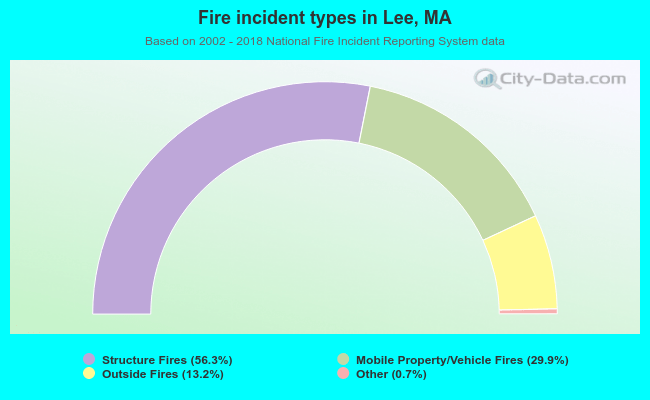 When looking into fire subcategories, the most reports belonged to: Structure Fires (56.2%), and Mobile Property/Vehicle Fires (29.9%).
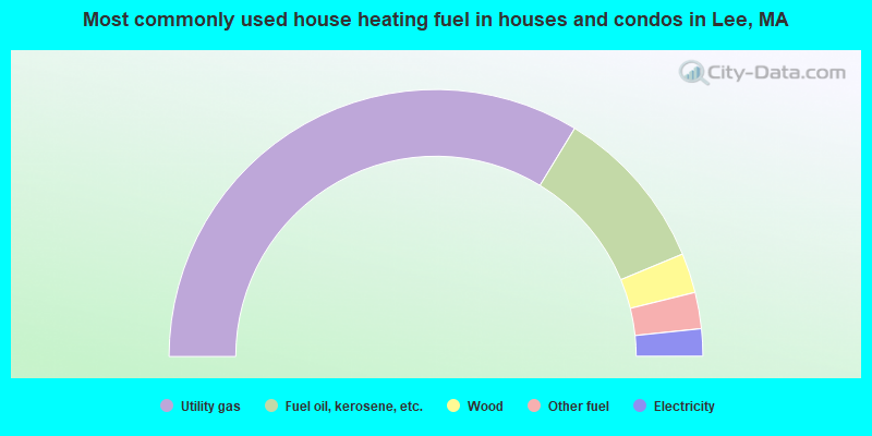
- 67.4%Utility gas
- 20.1%Fuel oil, kerosene, etc.
- 4.8%Wood
- 4.4%Other fuel
- 3.3%Electricity
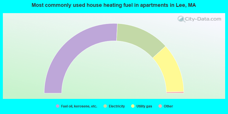
- 51.9%Fuel oil, kerosene, etc.
- 25.1%Electricity
- 23.0%Utility gas
Lee compared to Massachusetts state average:
- Median house value below state average.
- Unemployed percentage significantly below state average.
- Black race population percentage significantly below state average.
- Hispanic race population percentage significantly below state average.
- Foreign-born population percentage below state average.
- Institutionalized population percentage above state average.
Lee on our top lists:
- #20 on the list of "Top 101 cities with the most residents born in Other Australian and New Zealand Subregion (population 500+)"
- #43 on the list of "Top 101 cities with the most residents born in Portugal (population 500+)"
- #59 on the list of "Top 101 cities with the most residents born in Australia and New Zealand Subregion (population 500+)"
- #66 on the list of "Top 101 cities with the largest percentage of people in homes for the mentally retarded (population 1,000+)"
- #60 (01238) on the list of "Top 101 zip codes with the largest percentage of Lithuanian first ancestries (pop 5,000+)"
- #14 on the list of "Top 101 counties with the lowest number of births per 1000 residents 2007-2013"
- #22 on the list of "Top 101 counties with the lowest percentage of residents relocating from other counties between 2010 and 2011"
- #28 on the list of "Top 101 counties with the lowest percentage of residents relocating to other counties in 2011"
- #53 on the list of "Top 101 counties with highest percentage of residents voting for Obama (Democrat) in the 2012 Presidential Election"
- #71 on the list of "Top 101 counties with the largest number of people moving out compared to moving in (pop. 50,000+)"

|
|
Total of 33 patent applications in 2008-2024.