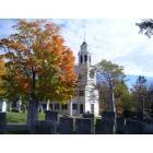
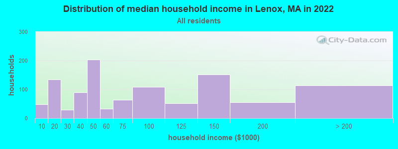
Lenox, Massachusetts
Submit your own pictures of this place and show them to the world
- OSM Map
- General Map
- Google Map
- MSN Map

Population change since 2000: +0.5%
| Males: 666 | |
| Females: 1,009 |
| Median resident age: | 66.8 years |
| Massachusetts median age: | 40.3 years |
Zip codes: 01240.
| Lenox: | $61,111 |
| MA: | $94,488 |
Estimated per capita income in 2022: $51,338 (it was $23,810 in 2000)
Lenox CDP income, earnings, and wages data
Estimated median house or condo value in 2022: $422,532 (it was $163,900 in 2000)
| Lenox: | $422,532 |
| MA: | $534,700 |
Mean prices in 2022: all housing units: $357,971; detached houses: $376,086; townhouses or other attached units: $341,816; in 2-unit structures: $250,940; in 3-to-4-unit structures: $400,871; in 5-or-more-unit structures: $281,990; mobile homes: $80,872
Median gross rent in 2022: $1,018.
Detailed information about poverty and poor residents in Lenox, MA


Compare current foreclosures near Lenox, MA:
| Photo | Address | Area | Beds / Baths | Price | Details |
|---|---|---|---|---|---|

|
#1
Melville Ct
Lenox, MA 01240
|
3,988 sq. feet
|
6 baths 5 beds |
show details | |

|
#2
Jennifer St
Lenox, MA 01240
|
1,416 sq. feet
|
1 baths 3 beds |
show details | |

|
#3
Morgan St
Lenox, MA 01240
|
3,959 sq. feet
|
2 baths 3 beds |
show details | |

|
#4
Crystal St
Lenox Dale, MA 01242
|
1,918 sq. feet
|
2 baths 3 beds |
$165,900
|
show details |

|
#5
Washington Mountain Rd
Lee, MA 01238
|
- sq. feet
|
1 baths 3 beds |
$155,000
|
show details |

|
#6
Circular Ave
Pittsfield, MA 01201
|
2,808 sq. feet
|
4 baths 8 beds |
show details | |

|
#7
Wilshire Dr
Cheshire, MA 01225
|
4,302 sq. feet
|
2 baths 3 beds |
show details | |

|
#8
North St
Pittsfield, MA 01201
|
1,661 sq. feet
|
2 baths 4 beds |
show details | |

|
#9
Weller Ave
Pittsfield, MA 01201
|
3,376 sq. feet
|
3 baths 6 beds |
show details | |

|
#10
Tierney Pl
Pittsfield, MA 01201
|
1,103 sq. feet
|
1 baths 3 beds |
show details |
| Photo | Address | Area | Beds / Baths | Price | Details |
|---|---|---|---|---|---|

|
#11
Madison Ave
Pittsfield, MA 01201
|
2,192 sq. feet
|
2 baths 6 beds |
show details | |

|
#12
Daniels Ave
Pittsfield, MA 01201
|
3,040 sq. feet
|
3 baths 6 beds |
show details | |

|
#13
Robbins Ave
Pittsfield, MA 01201
|
1,872 sq. feet
|
2 baths 4 beds |
show details | |

|
#14
Arnold Ct
Cheshire, MA 01225
|
1,600 sq. feet
|
2 baths 2 beds |
show details | |

|
#15
Williams St
Pittsfield, MA 01201
|
1,245 sq. feet
|
1 baths 3 beds |
show details | |

|
#16
Frisbee St
East Chatham, NY 12060
|
2,400 sq. feet
|
2 baths 4 beds |
show details | |

|
#17
Davis St
Pittsfield, MA 01201
|
1,456 sq. feet
|
2 baths 3 beds |
show details | |

|
#18
S Washington State Rd
Becket, MA 01223
|
1,620 sq. feet
|
1 baths 2 beds |
show details | |

|
#19
Hancock Rd
Pittsfield, MA 01201
|
1,344 sq. feet
|
2 baths 3 beds |
show details | |

|
#20
Upper Queechy Rd
Canaan, NY 12029
|
912 sq. feet
|
1 baths 2 beds |
show details |
| Photo | Address | Area | Beds / Baths | Price | Details |
|---|---|---|---|---|---|

|
#21
West St
Pittsfield, MA 01201
|
1,714 sq. feet
|
1 baths 4 beds |
show details | |

|
#22
Baker St
Lanesboro, MA 01237
|
1,231 sq. feet
|
1 baths 3 beds |
show details | |

|
#23
Ashuelot St
Dalton, MA 01226
|
1,792 sq. feet
|
2 baths 3 beds |
show details | |

|
#24
North St
Dalton, MA 01226
|
1,852 sq. feet
|
2 baths 4 beds |
show details | |

|
#25
Lenox Ave
Pittsfield, MA 01201
|
1,376 sq. feet
|
1 baths 3 beds |
show details | |

|
#26
Main St
Becket, MA 01223
|
1,512 sq. feet
|
2 baths 2 beds |
show details | |

|
#27
Grange Hall Rd
Stephentown, NY 12168
|
1,670 sq. feet
|
1 baths 2 beds |
show details | |

|
#28
David Dr
Hinsdale, MA 01235
|
1,664 sq. feet
|
2 baths 3 beds |
show details | |

|
#29
County Rd
Great Barrington, MA 01230
|
1,576 sq. feet
|
1 baths 4 beds |
show details | |

|
#30
Rte 9
Windsor, MA 01270
|
1,223 sq. feet
|
1 baths 2 beds |
show details |
| Photo | Address | Area | Beds / Baths | Price | Details |
|---|---|---|---|---|---|

|
#31
Middlefield Rd
Chester, MA 01011
|
1,760 sq. feet
|
2 baths 3 beds |
show details | |

|
#32
County Route 21
Ghent, NY 12075
|
2,819 sq. feet
|
2 baths 6 beds |
show details | |

|
#33
Roxbury Rd
Chatham, NY 12037
|
1,820 sq. feet
|
1 baths 3 beds |
show details | |

|
#34
Lenox Ave
Pittsfield, MA 01201
|
2,290 sq. feet
|
2 baths 6 beds |
show details | |

|
#35
Imperial Ave
Pittsfield, MA 01201
|
1,326 sq. feet
|
1 baths 3 beds |
show details | |

|
#36
Elberon Ave
Pittsfield, MA 01201
|
1,794 sq. feet
|
1 baths 4 beds |
show details | |

|
#37
West St
Pittsfield, MA 01201
|
2,018 sq. feet
|
1 baths 3 beds |
show details | |

|
#38
Summit Ave
Pittsfield, MA 01201
|
1,664 sq. feet
|
2 baths 4 beds |
show details | |

|
#39
Briggs Ave
Pittsfield, MA 01201
|
2,116 sq. feet
|
2 baths 4 beds |
show details | |

|
#40
Anita Dr
Pittsfield, MA 01201
|
1,504 sq. feet
|
2 baths 3 beds |
show details |
| Photo | Address | Area | Beds / Baths | Price | Details |
|---|---|---|---|---|---|

|
#41
Daniels Ave
Pittsfield, MA 01201
|
1,172 sq. feet
|
1 baths 3 beds |
show details | |

|
#42
Joseph Dr
Pittsfield, MA 01201
|
1,248 sq. feet
|
1 baths 3 beds |
show details | |

|
#43
Kathy Way
Pittsfield, MA 01201
|
2,136 sq. feet
|
2 baths 3 beds |
show details | |

|
#44
Garfield Ave
Pittsfield, MA 01201
|
2,432 sq. feet
|
2 baths 4 beds |
show details | |

|
#45
Chapel St
Lee, MA 01238
|
1,584 sq. feet
|
1 baths 3 beds |
show details | |

|
#46
Crystal St
Pittsfield, MA 01201
|
1,282 sq. feet
|
1 baths 3 beds |
show details | |

|
#47
Mcarthur St
Pittsfield, MA 01201
|
1,155 sq. feet
|
1 baths 2 beds |
show details | |

|
#48
Donovan St
Pittsfield, MA 01201
|
1,652 sq. feet
|
2 baths 3 beds |
show details | |

|
#49
East St
Lee, MA 01238
|
1,478 sq. feet
|
2 baths 3 beds |
show details | |

|
Check over 1 million property listings on Foreclosure.com!
|
browse all offers | |||


- 1,78790.1%White alone
- 1055.3%Hispanic
- 542.7%Two or more races
- 180.9%Black alone
- 100.5%Asian alone
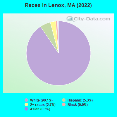
Races in Lenox detailed stats: ancestries, foreign born residents, place of birth
Type |
2009 |
2010 |
2011 |
2012 |
2013 |
2014 |
2015 |
2016 |
2017 |
2018 |
2019 |
2020 |
2021 |
2022 |
|---|---|---|---|---|---|---|---|---|---|---|---|---|---|---|
| Murders (per 100,000) | 0 (0.0) | 0 (0.0) | 0 (0.0) | 0 (0.0) | 0 (0.0) | 0 (0.0) | 0 (0.0) | 0 (0.0) | 0 (0.0) | 0 (0.0) | 0 (0.0) | 0 (0.0) | 0 (0.0) | 0 (0.0) |
| Rapes (per 100,000) | 0 (0.0) | 1 (19.9) | 0 (0.0) | 0 (0.0) | 1 (20.0) | 1 (20.1) | 1 (20.1) | 1 (20.1) | 3 (60.6) | 5 (101.2) | 2 (40.4) | 1 (20.3) | 1 (20.3) | 1 (19.6) |
| Robberies (per 100,000) | 0 (0.0) | 2 (39.8) | 0 (0.0) | 0 (0.0) | 0 (0.0) | 1 (20.1) | 0 (0.0) | 0 (0.0) | 1 (20.2) | 0 (0.0) | 0 (0.0) | 2 (40.6) | 2 (40.7) | 0 (0.0) |
| Assaults (per 100,000) | 10 (193.8) | 5 (99.5) | 4 (79.1) | 5 (99.2) | 3 (60.1) | 5 (100.5) | 4 (80.2) | 7 (140.8) | 7 (141.5) | 6 (121.4) | 5 (101.0) | 7 (142.0) | 2 (40.7) | 4 (78.4) |
| Burglaries (per 100,000) | 48 (930.2) | 30 (597.0) | 24 (474.7) | 31 (615.2) | 35 (701.0) | 15 (301.6) | 18 (361.0) | 11 (221.3) | 16 (323.4) | 8 (161.9) | 11 (222.2) | 6 (121.7) | 9 (182.9) | 7 (137.1) |
| Thefts (per 100,000) | 92 (1,783) | 76 (1,512) | 86 (1,701) | 79 (1,568) | 83 (1,662) | 83 (1,669) | 63 (1,264) | 67 (1,348) | 64 (1,294) | 70 (1,417) | 59 (1,192) | 38 (770.8) | 48 (975.6) | 72 (1,410) |
| Auto thefts (per 100,000) | 2 (38.8) | 2 (39.8) | 1 (19.8) | 1 (19.8) | 2 (40.1) | 3 (60.3) | 1 (20.1) | 2 (40.2) | 3 (60.6) | 0 (0.0) | 1 (20.2) | 0 (0.0) | 1 (20.3) | 4 (78.4) |
| Arson (per 100,000) | 1 (19.4) | 0 (0.0) | 0 (0.0) | 1 (19.8) | 1 (20.0) | 0 (0.0) | 0 (0.0) | 0 (0.0) | 0 (0.0) | 0 (0.0) | 0 (0.0) | 0 (0.0) | 0 (0.0) | 0 (0.0) |
| City-Data.com crime index | 178.3 | 153.2 | 118.7 | 127.2 | 146.8 | 134.9 | 109.5 | 116.9 | 162.1 | 173.2 | 117.4 | 96.1 | 90.0 | 103.6 |
The City-Data.com crime index weighs serious crimes and violent crimes more heavily. Higher means more crime, U.S. average is 246.1. It adjusts for the number of visitors and daily workers commuting into cities.
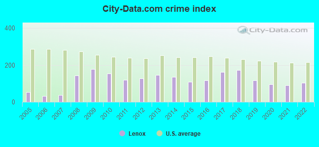
Crime rate in Lenox detailed stats: murders, rapes, robberies, assaults, burglaries, thefts, arson
Full-time law enforcement employees in 2021, including police officers: 11 (11 officers - 11 male; 0 female).
| Officers per 1,000 residents here: | 2.24 |
| Massachusetts average: | 2.53 |
 Recent articles from our blog. Our writers, many of them Ph.D. graduates or candidates, create easy-to-read articles on a wide variety of topics.

 | Photos of MA-please limit to photos & their discussion only, thanks. (670 replies) |
| November 2022...closed restaurants, bars and shops (201 replies) |
| Boston crime thread - all posts go here. (2497 replies) |
| Where do Affluent Black Families live in MA? (222 replies) |
| Post Covid Boston - Restaurant and Entertainment closures (81 replies) |
| South End/Roxbury Crossing (63 replies) |
Latest news from Lenox, MA collected exclusively by city-data.com from local newspapers, TV, and radio stations
Lenox, MA City Guides:
Ancestries: Irish (24.0%), Polish (15.2%), English (9.0%), Eastern European (6.9%), Moroccan (6.7%), Dutch (6.7%).
Current Local Time: EST time zone
Incorporated in 1775
Elevation: 1200 feet
Land area: 1.79 square miles.
Population density: 936 people per square mile (low).

216 residents are foreign born (2.9% Europe, 2.7% Africa, 2.5% Latin America, 1.8% North America).
| This place: | 10.9% |
| Massachusetts: | 17.6% |
Median real estate property taxes paid for housing units with mortgages in 2022: $6,573 (0.9%)
Median real estate property taxes paid for housing units with no mortgage in 2022: $2,541 (0.9%)
Nearest city with pop. 50,000+: Albany, NY  (32.9 miles , pop. 95,658).
Nearest city with pop. 200,000+: Bronx, NY (108.8 miles , pop. 1,332,650).
Nearest cities:
), ), ), ), )Latitude: 42.36 N, Longitude: 73.28 W
Area code: 413
Lenox tourist attractions:
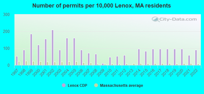
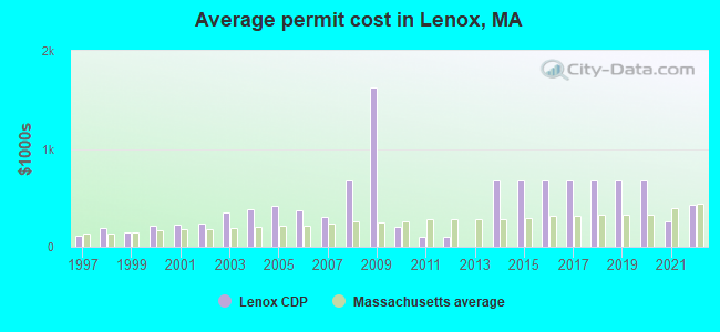
Single-family new house construction building permits:
- 2022: 15 buildings, average cost: $425,300
- 2021: 10 buildings, average cost: $259,200
- 2020: 16 buildings, average cost: $674,400
- 2019: 16 buildings, average cost: $674,400
- 2018: 16 buildings, average cost: $674,400
- 2017: 16 buildings, average cost: $674,400
- 2016: 16 buildings, average cost: $674,400
- 2015: 14 buildings, average cost: $674,400
- 2014: 16 buildings, average cost: $674,400
- 2012: 10 buildings, average cost: $107,100
- 2011: 9 buildings, average cost: $107,100
- 2010: 8 buildings, average cost: $202,900
- 2009: 2 buildings, average cost: $1,623,500
- 2008: 11 buildings, average cost: $679,900
- 2007: 12 buildings, average cost: $309,100
- 2006: 15 buildings, average cost: $373,300
- 2005: 27 buildings, average cost: $417,600
- 2004: 27 buildings, average cost: $387,300
- 2003: 15 buildings, average cost: $346,700
- 2002: 35 buildings, average cost: $241,100
- 2001: 26 buildings, average cost: $224,700
- 2000: 20 buildings, average cost: $217,700
- 1999: 31 buildings, average cost: $148,500
- 1998: 15 buildings, average cost: $189,200
- 1997: 9 buildings, average cost: $115,600
| Here: | 3.8% |
| Massachusetts: | 3.5% |
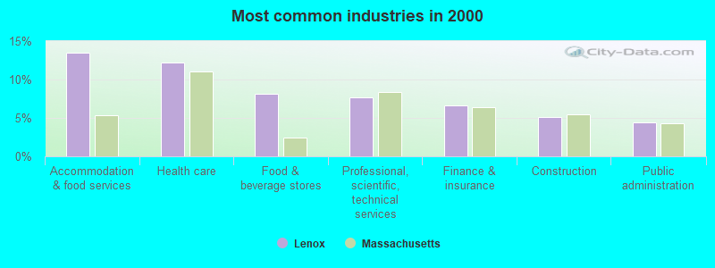
- Accommodation & food services (13.4%)
- Health care (12.2%)
- Food & beverage stores (8.2%)
- Professional, scientific, technical services (7.6%)
- Finance & insurance (6.6%)
- Construction (5.1%)
- Public administration (4.4%)
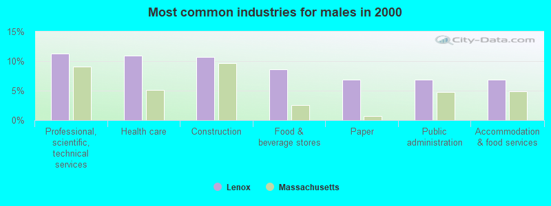
- Professional, scientific, technical services (11.2%)
- Health care (11.0%)
- Construction (10.7%)
- Food & beverage stores (8.6%)
- Paper (6.9%)
- Public administration (6.9%)
- Accommodation & food services (6.9%)
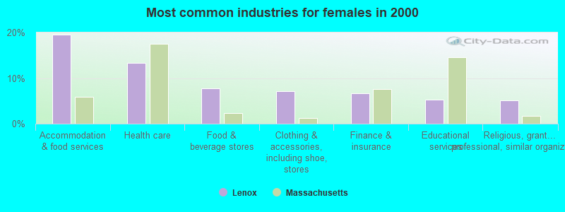
- Accommodation & food services (19.5%)
- Health care (13.3%)
- Food & beverage stores (7.7%)
- Clothing & accessories, including shoe, stores (7.2%)
- Finance & insurance (6.7%)
- Educational services (5.3%)
- Religious, grantmaking, civic, professional, similar organizations (5.1%)
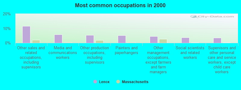
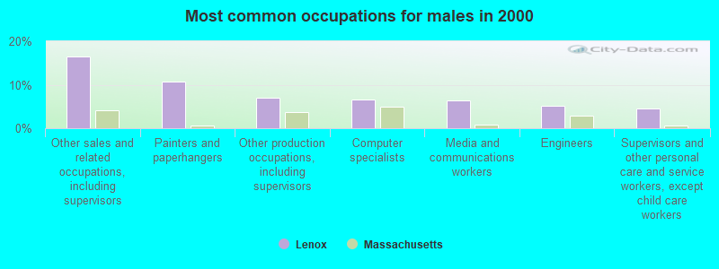
- Other sales and related occupations, including supervisors (11.6%)
- Media and communications workers (5.7%)
- Other production occupations, including supervisors (5.4%)
- Painters and paperhangers (5.1%)
- Other management occupations, except farmers and farm managers (4.6%)
- Social scientists and related workers (3.7%)
- Supervisors and other personal care and service workers, except child care workers (3.6%)
- Other sales and related occupations, including supervisors (16.4%)
- Painters and paperhangers (10.7%)
- Other production occupations, including supervisors (6.9%)
- Computer specialists (6.6%)
- Media and communications workers (6.3%)
- Engineers (5.2%)
- Supervisors and other personal care and service workers, except child care workers (4.6%)
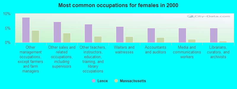
- Other management occupations, except farmers and farm managers (8.8%)
- Other sales and related occupations, including supervisors (7.2%)
- Other teachers, instructors, education, training, and library occupations (6.4%)
- Waiters and waitresses (5.6%)
- Accountants and auditors (5.1%)
- Media and communications workers (5.1%)
- Librarians, curators, and archivists (5.1%)
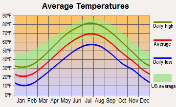
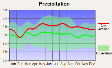
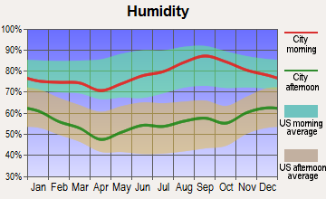
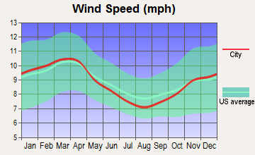
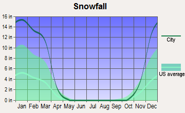
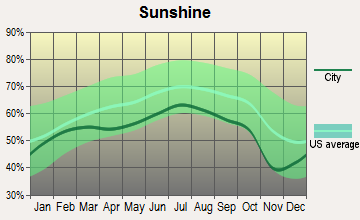
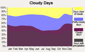
Average climate in Lenox, Massachusetts
Based on data reported by over 4,000 weather stations
|
|


(lower is better)
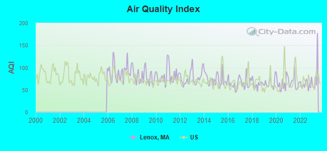
Air Quality Index (AQI) level in 2022 was 63.2. This is about average.
| City: | 63.2 |
| U.S.: | 72.6 |
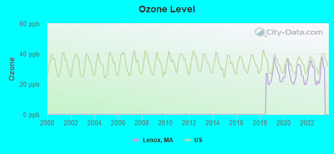
Ozone [ppb] level in 2022 was 27.5. This is better than average. Closest monitor was 7.0 miles away from the city center.
| City: | 27.5 |
| U.S.: | 33.3 |
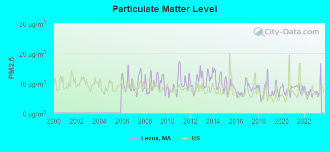
Particulate Matter (PM2.5) [µg/m3] level in 2022 was 6.76. This is about average. Closest monitor was 6.5 miles away from the city center.
| City: | 6.76 |
| U.S.: | 8.11 |
Tornado activity:
Lenox-area historical tornado activity is slightly above Massachusetts state average. It is 19% smaller than the overall U.S. average.
On 8/28/1973, a category F4 (max. wind speeds 207-260 mph) tornado 7.8 miles away from the Lenox place center killed 4 people and injured 36 people and caused between $5,000,000 and $50,000,000 in damages.
On 5/29/1995, a category F4 tornado 13.2 miles away from the place center killed 3 people and injured 24 people and caused between $5,000,000 and $50,000,000 in damages.
Earthquake activity:
Lenox-area historical earthquake activity is significantly above Massachusetts state average. It is 69% smaller than the overall U.S. average.On 10/7/1983 at 10:18:46, a magnitude 5.3 (5.1 MB, 5.3 LG, 5.1 ML, Class: Moderate, Intensity: VI - VII) earthquake occurred 122.6 miles away from Lenox center
On 4/20/2002 at 10:50:47, a magnitude 5.3 (5.3 ML, Depth: 3.0 mi) earthquake occurred 150.5 miles away from the city center
On 4/20/2002 at 10:50:47, a magnitude 5.2 (5.2 MB, 4.2 MS, 5.2 MW, 5.0 MW) earthquake occurred 148.9 miles away from the city center
On 1/19/1982 at 00:14:42, a magnitude 4.7 (4.5 MB, 4.7 MD, 4.5 LG, Class: Light, Intensity: IV - V) earthquake occurred 116.3 miles away from the city center
On 10/16/2012 at 23:12:25, a magnitude 4.7 (4.7 ML, Depth: 10.0 mi) earthquake occurred 158.2 miles away from Lenox center
On 6/17/1991 at 08:53:16, a magnitude 4.1 (4.0 MB, 4.0 LG, Depth: 3.1 mi) earthquake occurred 73.5 miles away from Lenox center
Magnitude types: regional Lg-wave magnitude (LG), body-wave magnitude (MB), duration magnitude (MD), local magnitude (ML), surface-wave magnitude (MS), moment magnitude (MW)
Natural disasters:
The number of natural disasters in Berkshire County (21) is greater than the US average (15).Major Disasters (Presidential) Declared: 10
Emergencies Declared: 10
Causes of natural disasters: Floods: 5, Snowstorms: 5, Storms: 5, Hurricanes: 4, Winter Storms: 4, Blizzards: 2, Snows: 2, Snowfall: 1, Tropical Storm: 1, Wind: 1, Other: 1 (Note: some incidents may be assigned to more than one category).

Hospitals and medical centers in Lenox:
Colleges/universities with over 2000 students nearest to Lenox:
- Williams College (about 25 miles; Williamstown, MA; Full-time enrollment: 2,141)
- Westfield State University (about 30 miles; Westfield, MA; FT enrollment: 5,548)
- Hudson Valley Community College (about 32 miles; Troy, NY; FT enrollment: 9,346)
- Rensselaer Polytechnic Institute (about 33 miles; Troy, NY; FT enrollment: 6,940)
- The Sage Colleges (about 34 miles; Troy, NY; FT enrollment: 2,499)
- Smith College (about 34 miles; Northampton, MA; FT enrollment: 3,549)
- The College of Saint Rose (about 34 miles; Albany, NY; FT enrollment: 4,085)
Public high school in Lenox:
- LENOX MEMORIAL HIGH (Students: 476, Location: 197 EAST STREET, Grades: 6-12)
Private high schools in Lenox:
Public elementary/middle school in Lenox:
- MORRIS (Students: 361, Location: 129 WEST STREET, Grades: PK-5)
Private elementary/middle school in Lenox:
Points of interest:
Notable locations in Lenox: Lenox Volunteer Ambulance Squad (A), Lenox Fire Department Central Station (B), Lenox Library Association (C), Blacksmith Museum (D), Lenox Library (E), Berkshire Performing Arts Center (F), Lenox Library Association Library (G). Display/hide their locations on the map
Shopping Center: Intown Mall Shopping Center (1). Display/hide its location on the map
Church in Lenox: Trinity Church (A). Display/hide its location on the map
Cemetery: Saint Anns Cemetery (1). Display/hide its location on the map
Swamps: The Marsh (A). Display/hide its location on the map
Tourist attractions: Berkshire Scenic Railway Museum (Willow Creek Road), Frelinghuysen Morris House & Studio (Museums; 92 Hawthorne Street), Edith Wharton Restoration-The Mount (Museums; 2 Plunkett Street), Lenox Chamber Of Commerce (5 Walker).
Hotels: Days Inn of Lenox (194 Pittsfield Road), Gables Inn (81 Walker Street), Apple Tree Inn & Restaurant (10 Richmond Mountain Road), Econo Lodge Lenox (130 Pittsfield Road), Garden Gables Inn (135 Main Street), Blantyre (Blantyre Road Po Box 995), Knights Inn Lenox MA (474 Pittsfield Road), Howard Johnson Express Inn (462 Pittsfield Rd), Seven Hills Country Inn and Restaurant (40 Plunkett Street).
Birthplace of: John Cameron Greenleaf - Architect, Lewis Greenleaf Adams - Architect, Mother Mary Alphonsa - Roman Catholic nun, Finn Wittrock - Actor.
Drinking water stations with addresses in Lenox and their reported violations in the past:
WHITE PINES CONDOMINIUMS (Population served: 225, Groundwater):Past health violations:Past monitoring violations:
- MCL, Monthly (TCR) - In JAN-2014, Contaminant: Coliform. Follow-up actions: St AO (w/o penalty) issued (FEB-21-2014)
- MCL, Acute (TCR) - In JUL-2009, Contaminant: Coliform. Follow-up actions: St AO (w/o penalty) issued (JUL-31-2009)
- MCL, Monthly (TCR) - In AUG-2008, Contaminant: Coliform. Follow-up actions: St AO (w/o penalty) issued (2 times from FEB-05-2009 to FEB-11-2010)
- MCL, Monthly (TCR) - In JUL-2008, Contaminant: Coliform. Follow-up actions: St AO (w/o penalty) issued (2 times from FEB-05-2009 to FEB-11-2010)
- Monitoring, Repeat Major (TCR) - In JAN-2014, Contaminant: Coliform (TCR). Follow-up actions: St AO (w/o penalty) issued (FEB-21-2014)
- Follow-up Or Routine LCR Tap M/R - In JAN-01-2013, Contaminant: Lead and Copper Rule. Follow-up actions: St AO (w/o penalty) issued (FEB-14-2014)
- Follow-up Or Routine LCR Tap M/R - In JUN-01-2011, Contaminant: Lead and Copper Rule. Follow-up actions: St AO (w/o penalty) issued (NOV-08-2011)
- 2 minor monitoring violations
Drinking water stations with addresses in Lenox that have no violations reported:
- LENOX DPW WATER DIVISION (Population served: 9,800, Primary Water Source Type: Surface water)
| This place: | 1.7 people |
| Massachusetts: | 2.5 people |
| This place: | 35.5% |
| Whole state: | 63.0% |
| This place: | 3.7% |
| Whole state: | 7.0% |
Likely homosexual households (counted as self-reported same-sex unmarried-partner households)
- Lesbian couples: 0.2% of all households
- Gay men: 0.2% of all households
People in group quarters in Lenox in 2010:
- 71 people in nursing facilities/skilled-nursing facilities
- 7 people in college/university student housing
- 6 people in group homes intended for adults
Banks with branches in Lenox (2011 data):
- Berkshire Bank: Lenox Savings Bank Branch at 25 Main Street, branch established on 1890/01/01; Pittsfield Road Branch at 495 Pittsfield Road, branch established on 1977/10/15. Info updated 2011/08/24: Bank assets: $3,955.6 mil, Deposits: $3,176.2 mil, headquarters in Pittsfield, MA, positive income, Commercial Lending Specialization, 64 total offices
- The Lenox National Bank: at 7 Main Street, branch established on 1889/04/18. Info updated 2006/11/03: Bank assets: $60.0 mil, Deposits: $52.2 mil, local headquarters, positive income, 1 total offices
- NBT Bank, National Association: Lenox Branch at 2 Holmes Road, branch established on 2012/02/07. Info updated 2012/02/02: Bank assets: $5,558.5 mil, Deposits: $4,381.4 mil, headquarters in Norwich, NY, positive income, Commercial Lending Specialization, 133 total offices, Holding Company: Nbt Bancorp Inc.
For population 15 years and over in Lenox:
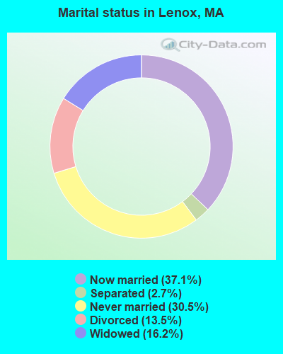
- Never married: 30.5%
- Now married: 37.1%
- Separated: 2.7%
- Widowed: 16.2%
- Divorced: 13.5%
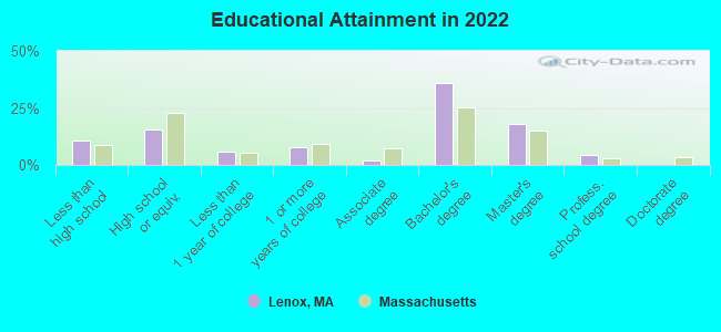
For population 25 years and over in Lenox:
- High school or higher: 90.6%
- Bachelor's degree or higher: 57.7%
- Graduate or professional degree: 22.4%
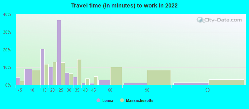
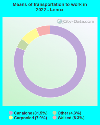
- Mean travel time to work (commute): 13.7 minutes
| Here: | 12.4 |
| Massachusetts average: | 13.0 |


Graphs represent county-level data. Detailed 2008 Election Results
Religion statistics for Lenox, MA (based on Berkshire County data)


| Religion | Adherents | Congregations |
|---|---|---|
| Catholic | 50,187 | 32 |
| Mainline Protestant | 9,895 | 63 |
| Other | 3,647 | 20 |
| Evangelical Protestant | 2,817 | 28 |
| Black Protestant | 233 | 2 |
| Orthodox | 225 | 2 |
| None | 64,215 | - |
Food Environment Statistics:
| This county: | 2.54 / 10,000 pop. |
| Massachusetts: | 1.98 / 10,000 pop. |
| Berkshire County: | 1.61 / 10,000 pop. |
| Massachusetts: | 2.22 / 10,000 pop. |
| Berkshire County: | 4.08 / 10,000 pop. |
| State: | 1.77 / 10,000 pop. |
| Berkshire County: | 15.00 / 10,000 pop. |
| State: | 8.76 / 10,000 pop. |
| This county: | 8.0% |
| Massachusetts: | 8.1% |
| This county: | 22.8% |
| Massachusetts: | 22.5% |
| This county: | 9.9% |
| Massachusetts: | 16.5% |
Health and Nutrition:
| Lenox: | 51.8% |
| State: | 50.5% |
| Here: | 47.5% |
| State: | 48.0% |
| This city: | 28.6 |
| Massachusetts: | 28.4 |
| Here: | 21.3% |
| Massachusetts: | 20.7% |
| Here: | 12.1% |
| Massachusetts: | 10.4% |
| Here: | 7.0 |
| State: | 6.8 |
| Lenox: | 34.3% |
| Massachusetts: | 33.4% |
| Lenox: | 55.7% |
| State: | 57.1% |
| Lenox: | 74.3% |
| State: | 79.2% |
More about Health and Nutrition of Lenox, MA Residents
| Businesses in Lenox, MA | ||||
| Name | Count | Name | Count | |
|---|---|---|---|---|
| CVS | 1 | New Balance | 2 | |
| Days Inn | 1 | RadioShack | 1 | |
| Econo Lodge | 1 | SAS Shoes | 1 | |
| FedEx | 1 | Subway | 1 | |
| Hilton | 1 | T-Mobile | 1 | |
| Howard Johnson | 1 | Talbots | 1 | |
| Knights Inn | 1 | Vans | 1 | |
| Marshalls | 1 | |||
Strongest AM radio stations in Lenox:
- WUHN (1110 AM; daytime; 5 kW; PITTSFIELD, MA; Owner: WEINER BROADCASTING, INC.)
- WNNZ (640 AM; 50 kW; WESTFIELD, MA; Owner: CLEAR CHANNEL BROADCASTING LICENSES, INC.)
- WSBS (860 AM; 3 kW; GREAT BARRINGTON, MA; Owner: BERKSHIRE BROADCASTING CO., INC.)
- WGY (810 AM; 50 kW; SCHENECTADY, NY; Owner: CLEAR CHANNEL BROADCASTING LICENSES, INC.)
- WPTR (1540 AM; 50 kW; ALBANY, NY; Owner: KIMTRON, INC.)
- WTIC (1080 AM; 50 kW; HARTFORD, CT; Owner: INFINITY RADIO OPERATIONS INC.)
- WBEC (1420 AM; 1 kW; PITTSFIELD, MA; Owner: GREAT NORTHERN RADIO, LLC)
- WBRK (1340 AM; 1 kW; PITTSFIELD, MA; Owner: WBRK, INC.)
- WCRN (830 AM; 50 kW; WORCESTER, MA; Owner: CARTER BROADCASTING CORPORATION)
- WROW (590 AM; 5 kW; ALBANY, NY; Owner: 6 JOHNSON ROAD LICENSES, INC.)
- WVNE (760 AM; daytime; 25 kW; LEICESTER, MA; Owner: BLOUNT MASSCOM, INC.)
- WHYN (560 AM; 5 kW; SPRINGFIELD, MA; Owner: CLEAR CHANNEL BROADCASTING LICENSES, INC.)
- WFAN (660 AM; 50 kW; NEW YORK, NY; Owner: INFINITY BROADCASTING OPERATIONS, INC.)
Strongest FM radio stations in Lenox:
- WBEC-FM (105.5 FM; PITTSFIELD, MA; Owner: GREAT NORTHERN RADIO, LLC)
- WUPE (95.9 FM; PITTSFIELD, MA; Owner: WEINER BROADCASTING, INC.)
- WHVP (91.1 FM; HUDSON, NY; Owner: SOUND OF LIFE, INC.)
- WAMC-FM (90.3 FM; ALBANY, NY; Owner: WAMC)
- WAMQ (105.1 FM; GREAT BARRINGTON, MA; Owner: WAMC)
- WZEC (97.5 FM; HOOSICK FALLS, NY; Owner: GREAT NORTHERN RADIO, LLC)
- WEQX (102.7 FM; MANCHESTER, VT; Owner: NORTHSHIRE COMMUNICATIONS, INC.)
- WJAN (95.1 FM; SUNDERLAND, VT; Owner: 6 JOHNSON ROAD LICENSES, INC.)
- WHYN-FM (93.1 FM; SPRINGFIELD, MA; Owner: CLEAR CHANNEL BROADCASTING LICENSES, INC.)
- WVAY (100.7 FM; WILMINGTON, VT; Owner: GREAT NORTHERN RADIO, L.L.C.)
- WAMK (90.9 FM; KINGSTON, NY; Owner: W A M C)
- WFGB (89.7 FM; KINGSTON, NY; Owner: SOUND OF LIFE, INC.)
- WBRK-FM (101.7 FM; PITTSFIELD, MA; Owner: WBRK, INC.)
- WRNX (100.9 FM; AMHERST, MA; Owner: WESTERN MASSACHUSETTS RADIO COMPANY)
- WAJZ (96.3 FM; VOORHEESVILLE, NY; Owner: 6 JOHNSON ROAD LICENSES, INC.)
- WZMR (104.9 FM; ALTAMONT, NY; Owner: 6 JOHNSON ROAD LICENSES, INC.)
- WYJB (95.5 FM; ALBANY, NY; Owner: 6 JOHNSON ROAD LICENSES, INC.)
- WGNA-FM (107.7 FM; ALBANY, NY; Owner: REGENT LICENSEE OF MANSFIELD, INC.)
- WAQY (102.1 FM; SPRINGFIELD, MA; Owner: SAGA COMMUNICATIONS OF NEW ENGLAND, LLC)
- WRVE (99.5 FM; SCHENECTADY, NY; Owner: CLEAR CHANNEL BROADCASTING LICENSES, INC.)
TV broadcast stations around Lenox:
- WTIC-TV (Channel 61; HARTFORD, CT; Owner: TRIBUNE TELEVISION COMPANY)
- W11BJ (Channel 11; HARTFORD, CT; Owner: COMMUNICATIONS SITE MANAGEMENT LLC)
- WTXX (Channel 20; WATERBURY, CT; Owner: WTXX INC.)
- W07AI (Channel 7; PITTSFIELD, ETC., MA; Owner: WNYT-TV, LLC)
- WCDC-TV (Channel 19; ADAMS, MA; Owner: YOUNG BROADCASTING OF ALBANY, INC.)
- Lenox, Massachusetts
- Fatal accident count42
- Vehicles involved in fatal accidents64
- Fatal accidents involving drunk persons:6
- Fatalities48
- Persons involved in fatal accidents98
- Pedestrians involved in fatal accidents7
- Massachusetts average
- Fatal accident count13128
- Vehicles involved in fatal accidents18520
- Fatal accidents involving drunk persons4215
- Fatalities14151
- Persons involved in fatal accidents30268
- Pedestrians involved in fatal accidents1466
- National Bridge Inventory (NBI) Statistics
- 1Number of bridges
- 3ft / 1.1mTotal length
- 129Total average daily traffic
- 2Total average daily truck traffic
FCC Registered Antenna Towers:
13 (See the full list of FCC Registered Antenna Towers in Lenox)FCC Registered Broadcast Land Mobile Towers:
11 (See the full list of FCC Registered Broadcast Land Mobile Towers in Lenox, MA)FCC Registered Microwave Towers:
7- STATION, 270 Pittsfield Rd (Lat: 42.370639 Lon: -73.279250), Structure height: 7.6 m, Overall height: 11.3 m, Call Sign: WNEO310,
Assigned Frequencies: 952.062 MHz, 928.062 MHz, Grant Date: 10/01/1998, Expiration Date: 12/30/2008, Cancellation Date: 03/07/2009, Phone: (617) 849-5503
- LENOX MTN, Yokum Road 2.9 Miles Nw Of (Lat: 42.393361 Lon: -73.310972), Type: Ltower, Structure height: 23.8 m, Call Sign: WQGL284,
Assigned Frequencies: 10556.2 MHz, 10556.2 MHz, 954.750 MHz, 933.775 MHz, Grant Date: 02/21/2007, Expiration Date: 02/21/2017, Cancellation Date: 04/29/2017, Certifier: William Brown, Registrant: Ess, Inc., Po Box 3051, West Caldwell, NJ 07007, Phone: (856) 764-3809, Email:
- LENOX, Yokum Road 2.9 Miles Nw Of (Lat: 42.393361 Lon: -73.310972), Type: Tower, Structure height: 23.8 m, Call Sign: WQPA991,
Assigned Frequencies: 6755.00 MHz, Grant Date: 03/26/2012, Expiration Date: 03/26/2022, Cancellation Date: 04/01/2016, Certifier: Russell Sienkiewicz, Registrant: Cromack Industries, Inc., 22 Rockland Rd, Greenfield, MA 01302, Phone: (413) 774-6500, Email:
- BERKSHIRE, Lat: 42.375306 Lon: -73.213944, Type: Building, Structure height: 12 m, Overall height: 16 m, Call Sign: WQVK773, Licensee ID: L01184639,
Assigned Frequencies: 3650.00 MHz, Grant Date: 03/13/2015, Expiration Date: 03/13/2025, Certifier: Thomas Wierimaa, Registrant: Onvoy Spectrum, LLC
- LENOX MTN, Yokum Road 2.9 Miles Nw Of (Lat: 42.393361 Lon: -73.310972), Type: Ltower, Structure height: 23.8 m, Call Sign: WRCU990, Licensee ID: L00758938,
Assigned Frequencies: 6815.00 MHz, 6785.00 MHz, Grant Date: 02/05/2019, Expiration Date: 02/05/2029, Certifier: Thomas Grady, Registrant: Berkshire County Sheriffs Office, 467 Cheshire Road, Pittsfield, MA 01201, Phone: (413) 443-7200, Fax: (413) 448-5328, Email:
- BOHVN00197A, 90 Pittsfield Road (Lat: 42.379194 Lon: -73.274917), Type: Mtower, Structure height: 44.5 m, Call Sign: WRWI861,
Assigned Frequencies: 19475.0 MHz, 19475.0 MHz, 19475.0 MHz, 19475.0 MHz, 19475.0 MHz, 19475.0 MHz, 19475.0 MHz, 19475.0 MHz, 19475.0 MHz, 19475.0 MHz, 19475.0 MHz, 19475.0 MHz, Grant Date: 02/27/2023, Expiration Date: 02/27/2033, Certifier: Alison Minea, Registrant: Dish Wireless L.L.C., 9601 S Meridan Blvd, Englewood, CO 80112, Phone: (202) 463-3709, Email:
- LENOX, 270 Pittsfield Rd (Lat: 42.370639 Lon: -73.279250), Type: Tower, Structure height: 24.4 m, Overall height: 25.9 m, Call Sign: KCE43,
Assigned Frequencies: 6286.19 MHz, Grant Date: 10/08/2020, Expiration Date: 09/26/2030, Registrant: Massachusetts, Commonwealth Of, 10 Park Plaza Rm 7410, Boston, MA 02116, Phone: (617) 835-6920, Email:
FCC Registered Amateur Radio Licenses:
24 (See the full list of FCC Registered Amateur Radio Licenses in Lenox)FAA Registered Aircraft:
4- Aircraft: HAWKER BEECHCRAFT CORP C90GTI (Category: Land, Engines: 2, Seats: 6, Weight: Up to 12,499 Pounds), Engine: P&W CANADA PT6A-135A (750 HP) (Turbo-prop)
N-Number: 158J, N158J, N-158J, Serial Number: LJ-1859, Year manufactured: 2007, Airworthiness Date: 12/31/2007, Certificate Issue Date: 09/27/2019
Registrant (LLC): Mad River LLC, 21 Fairwynds Dr, Lenox, MA 01240 - Aircraft: PIPER AIRCRAFT INC PA46R-350T (Category: Land, Seats: 6, Weight: Up to 12,499 Pounds), Engine: LYCOMING TIO-540-AE2A (350 HP) (Reciprocating)
N-Number: 6093E, N6093E, N-6093E, Serial Number: 4692136, Year manufactured: 2010, Airworthiness Date: 01/20/2010, Certificate Issue Date: 05/17/2013
Registrant (Individual): Steven A D'Antonio, 263 W Mountain Rd, Lenox, MA 01240 - Aircraft: BEECH V35 (Category: Land, Seats: 6, Weight: Up to 12,499 Pounds, Speed: 150 mph), Engine: CONT MOTOR GTSIO-520-C (340 HP) (Reciprocating)
N-Number: 9456S, N9456S, N-9456S, Serial Number: D-8036, Year manufactured: 1966, Airworthiness Date: 03/30/1966, Certificate Issue Date: 07/11/2018
Registrant (Individual): Richard J Trustee Herrick, 24 Taconic Ave, Lenox, MA 01240 - Aircraft: PIPER PA-31T1 (Category: Land, Engines: 2, Seats: 7, Weight: Up to 12,499 Pounds), Engine: P&W CANADA PT6A-60A (1050 HP) (Turbo-prop)
N-Number: 9266Y, N9266Y, N-9266Y, Serial Number: 31T-1104008, Year manufactured: 1983, Airworthiness Date: 12/30/1983, Certificate Issue Date: 05/20/2013
Registrant (Corporation): Mad River Enterprises Inc, 21 Fairwynds Dr, Lenox, MA 01240
Deregistered: Cancel Date: 09/06/2019
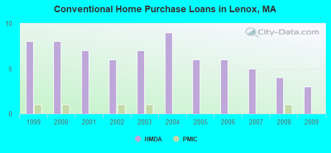
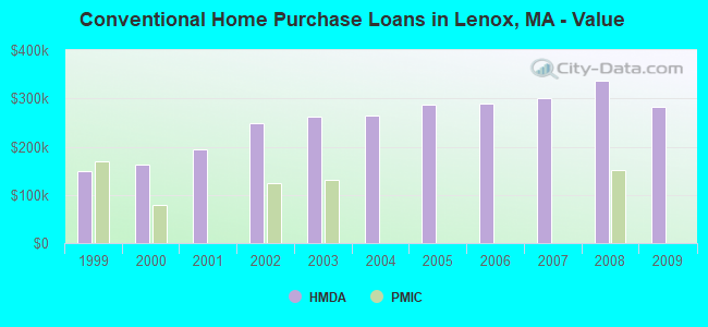
| Home Mortgage Disclosure Act Aggregated Statistics For Year 2009 (Based on 1 partial tract) | ||||||||
| B) Conventional Home Purchase Loans | C) Refinancings | D) Home Improvement Loans | F) Non-occupant Loans on < 5 Family Dwellings (A B C & D) | |||||
|---|---|---|---|---|---|---|---|---|
| Number | Average Value | Number | Average Value | Number | Average Value | Number | Average Value | |
| LOANS ORIGINATED | 3 | $281,370 | 16 | $269,635 | 2 | $168,990 | 4 | $308,825 |
| APPLICATIONS APPROVED, NOT ACCEPTED | 0 | $0 | 1 | $183,890 | 0 | $0 | 1 | $188,690 |
| APPLICATIONS DENIED | 1 | $118,220 | 2 | $321,350 | 0 | $0 | 1 | $263,460 |
| APPLICATIONS WITHDRAWN | 1 | $280,050 | 2 | $245,740 | 0 | $0 | 1 | $211,590 |
| FILES CLOSED FOR INCOMPLETENESS | 0 | $0 | 1 | $116,950 | 0 | $0 | 0 | $0 |
Detailed HMDA statistics for the following Tracts: 9131.00
| Private Mortgage Insurance Companies Aggregated Statistics For Year 2008 (Based on 1 partial tract) | ||
| A) Conventional Home Purchase Loans | ||
|---|---|---|
| Number | Average Value | |
| LOANS ORIGINATED | 1 | $152,070 |
| APPLICATIONS APPROVED, NOT ACCEPTED | 0 | $0 |
| APPLICATIONS DENIED | 0 | $0 |
| APPLICATIONS WITHDRAWN | 0 | $0 |
| FILES CLOSED FOR INCOMPLETENESS | 0 | $0 |
Detailed PMIC statistics for the following Tracts: 9131.00
2002 - 2018 National Fire Incident Reporting System (NFIRS) incidents
- Fire incident types reported to NFIRS in Lenox, MA
- 50267.2%Structure Fires
- 18725.0%Outside Fires
- 486.4%Mobile Property/Vehicle Fires
- 101.3%Other
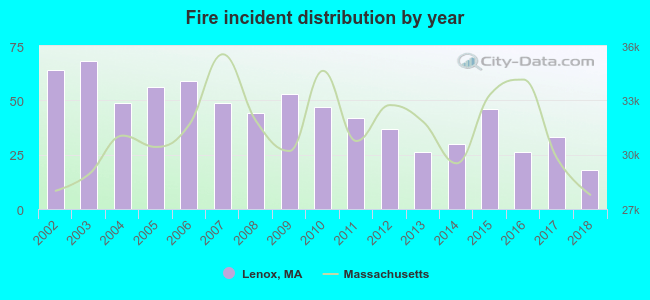 According to the data from the years 2002 - 2018 the average number of fire incidents per year is 44. The highest number of fires - 68 took place in 2003, and the least - 18 in 2018. The data has a dropping trend.
 When looking into fire subcategories, the most reports belonged to: Structure Fires (67.2%), and Outside Fires (25.0%).
Fire-safe hotels and motels in Lenox, Massachusetts:
- Econo Lodge, 390 Pittsfield Rd, Lenox, Massachusetts 01240 , Phone: (413) 637-4244, Fax: (413) 637-1969
- Knights Inn, 474 Pittsfield Rd, Lenox, Massachusetts 01240 , Phone: (413) 443-4468, Fax: (413) 443-0053
- Hampton Inn & Suites, 445 Pittsfield Rd, Lenox, Massachusetts 01240 , Phone: (413) 499-1111, Fax: (413) 499-4444
- Cranwell Resort, 55 Lee Rd, Lenox, Massachusetts 01240 , Phone: (413) 637-1364, Fax: (413) 634-0571
- Courtyard By Marriott Lenox Berkshires, 70 Pittsfield Rd, Lenox, Massachusetts 01240 , Phone: (413) 551-7700, Fax: (413) 551-7739
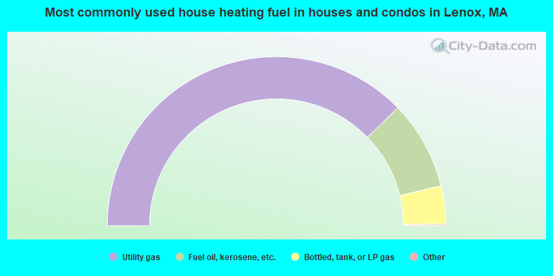
- 75.7%Utility gas
- 17.0%Fuel oil, kerosene, etc.
- 7.3%Bottled, tank, or LP gas
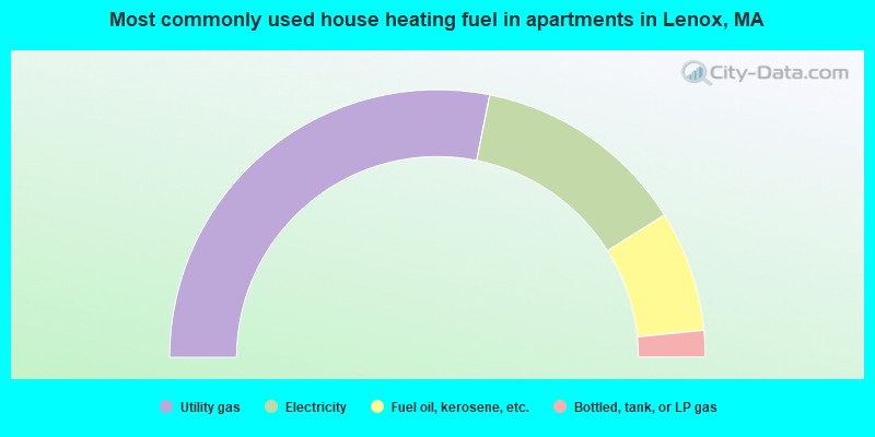
- 56.2%Utility gas
- 25.9%Electricity
- 14.6%Fuel oil, kerosene, etc.
- 3.2%Bottled, tank, or LP gas
Lenox compared to Massachusetts state average:
- Median household income below state average.
- Unemployed percentage significantly below state average.
- Black race population percentage significantly below state average.
- Hispanic race population percentage below state average.
- Median age significantly above state average.
- Length of stay since moving in significantly above state average.
- Number of rooms per house below state average.
- Institutionalized population percentage above state average.
- Percentage of population with a bachelor's degree or higher above state average.
Lenox on our top lists:
- #55 on the list of "Top 101 cities with the most people having professional degrees (population 500+)"
- #64 on the list of "Top 101 cities with the lowest percentage of family households, population 1,000+"
- #73 on the list of "Top 100 cities with the largest percentage of females"
- #6 (01240) on the list of "Top 101 zip codes with the largest percentage of Scottish first ancestries (pop 5,000+)"
- #14 on the list of "Top 101 counties with the lowest number of births per 1000 residents 2007-2013"
- #22 on the list of "Top 101 counties with the lowest percentage of residents relocating from other counties between 2010 and 2011"
- #28 on the list of "Top 101 counties with the lowest percentage of residents relocating to other counties in 2011"
- #53 on the list of "Top 101 counties with highest percentage of residents voting for Obama (Democrat) in the 2012 Presidential Election"
- #71 on the list of "Top 101 counties with the largest number of people moving out compared to moving in (pop. 50,000+)"

|
|
Total of 158 patent applications in 2008-2024.