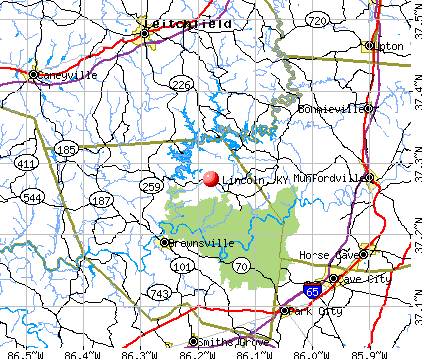
Lincoln, Kentucky
Submit your own pictures of this place and show them to the world
- OSM Map
- General Map
- Google Map
- MSN Map
| Males: 786 | |
| Females: 737 |
| Median resident age: | 40.5 years |
| Kentucky median age: | 35.9 years |
Zip code: 42259
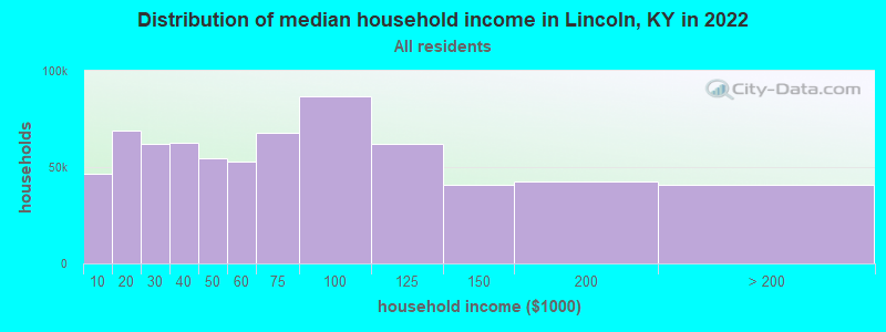
| Lincoln: | $52,367 |
| KY: | $59,341 |
Estimated per capita income in 2022: $24,312 (it was $12,965 in 2000)
Lincoln CCD income, earnings, and wages data
Estimated median house or condo value in 2022: $123,249 (it was $52,500 in 2000)
| Lincoln: | $123,249 |
| KY: | $196,300 |
Mean prices in 2022: all housing units: $160,385; detached houses: $211,035; mobile homes: $45,641
Detailed information about poverty and poor residents in Lincoln, KY
Compare current foreclosures near Lincoln, KY:
| Photo | Address | Area | Beds / Baths | Price | Details |
|---|---|---|---|---|---|

|
#1
Linda Ln
Bowling Green, KY 42101
|
1,890 sq. feet
|
1 baths 3 beds |
show details | |

|
#2
N Main St
Smiths Grove, KY 42171
|
1,538 sq. feet
|
1 baths 3 beds |
show details | |

|
#3
Old Mammoth Cave Rd
Cave City, KY 42127
|
1,884 sq. feet
|
2 baths 3 beds |
show details | |

|
#4
Broadway St
Cave City, KY 42127
|
1,987 sq. feet
|
1 baths 2 beds |
show details | |

|
#5
S Dixie Hwy
Munfordville, KY 42765
|
1,590 sq. feet
|
1 baths 4 beds |
show details | |

|
#6
Ky Highway 185
Bowling Green, KY 42101
|
1,200 sq. feet
|
2 baths 3 beds |
show details | |

|
#7
Penns Chapel Rd
Bowling Green, KY 42101
|
1,745 sq. feet
|
2 baths 3 beds |
show details | |

|
#8
Hunting Trail Rd
Munfordville, KY 42765
|
2,150 sq. feet
|
2 baths 3 beds |
show details | |

|
#9
Main St
Munfordville, KY 42765
|
1,890 sq. feet
|
2 baths 4 beds |
show details | |

|
#10
Lone Star Rd
Upton, KY 42784
|
1,792 sq. feet
|
2 baths 3 beds |
show details |
| Photo | Address | Area | Beds / Baths | Price | Details |
|---|---|---|---|---|---|

|
#11
N Buckner Ave
Munfordville, KY 42765
|
1,352 sq. feet
|
1 baths 3 beds |
show details | |

|
#12
N 3rd St
Cave City, KY 42127
|
1,596 sq. feet
|
2 baths 4 beds |
show details | |

|
#13
Elk St
Munfordville, KY 42765
|
1,120 sq. feet
|
1 baths 3 beds |
show details | |

|
#14
Elk St
Munfordville, KY 42765
|
1,084 sq. feet
|
1 baths 2 beds |
show details | |

|
#15
Campground Rd
Bonnieville, KY 42713
|
1,168 sq. feet
|
1 baths 3 beds |
show details | |

|
#16
Martin Rd
Horse Cave, KY 42749
|
1,458 sq. feet
|
1 baths 3 beds |
show details | |

|
#17
Anna Sandhill Rd
Bowling Green, KY 42101
|
1,688 sq. feet
|
1 baths 2 beds |
show details | |

|
#18
Sunset Ave
Smiths Grove, KY 42171
|
1,496 sq. feet
|
2 baths 2 beds |
show details | |

|
#19
Julia Ln
Munfordville, KY 42765
|
1,536 sq. feet
|
2 baths 4 beds |
show details | |

|
#20
Girkin Boiling Springs Rd
Bowling Green, KY 42101
|
1,890 sq. feet
|
2 baths 3 beds |
show details |
| Photo | Address | Area | Beds / Baths | Price | Details |
|---|---|---|---|---|---|

|
#21
Comer Ave
Horse Cave, KY 42749
|
1,089 sq. feet
|
1 baths 2 beds |
show details | |

|
#22
New St
Horse Cave, KY 42749
|
1,765 sq. feet
|
2 baths 3 beds |
show details | |

|
#23
E 4th St
Smiths Grove, KY 42171
|
- sq. feet
|
- baths - beds |
show details | |

|
#24
Morning Dove Ln
Brownsville, KY 42210
|
- sq. feet
|
- baths - beds |
show details | |

|
#25
Marina Ct
Cave City, KY 42127
|
- sq. feet
|
- baths - beds |
show details | |

|
#26
Old Main St Apt 308
Munfordville, KY 42765
|
- sq. feet
|
- baths - beds |
show details | |

|
#27
S Patterson St
Clarkson, KY 42726
|
- sq. feet
|
- baths - beds |
show details | |

|
#28
Concord Church Rd
Bonnieville, KY 42713
|
980 sq. feet
|
- baths - beds |
show details | |

|
#29
Millerstown St # 343
Clarkson, KY 42726
|
- sq. feet
|
- baths - beds |
show details | |

|
#30
Shawnee Run
Clarkson, KY 42726
|
- sq. feet
|
- baths - beds |
show details |
| Photo | Address | Area | Beds / Baths | Price | Details |
|---|---|---|---|---|---|

|
#31
Main St
Munfordville, KY 42765
|
- sq. feet
|
- baths - beds |
show details | |

|
#32
Blackrock Rd
Leitchfield, KY 42754
|
- sq. feet
|
- baths - beds |
show details | |

|
#33
Wall St
Cave City, KY 42127
|
- sq. feet
|
- baths - beds |
show details | |

|
#34
Main St
Oakland, KY 42159
|
- sq. feet
|
- baths - beds |
show details | |

|
#35
Bear Creek Dr
Leitchfield, KY 42754
|
- sq. feet
|
- baths - beds |
show details | |

|
#36
Paradise Point Rd
Clarkson, KY 42726
|
- sq. feet
|
- baths - beds |
show details | |

|
#37
Shrewsbury Rd
Leitchfield, KY 42754
|
- sq. feet
|
- baths - beds |
show details | |

|
#38
Oklahoma Rd
Bee Spring, KY 42207
|
- sq. feet
|
- baths - beds |
show details | |

|
#39
Anneta Rd
Leitchfield, KY 42754
|
- sq. feet
|
- baths - beds |
show details | |

|
#40
Ridgecrest Dr
Clarkson, KY 42726
|
- sq. feet
|
- baths - beds |
show details |
| Photo | Address | Area | Beds / Baths | Price | Details |
|---|---|---|---|---|---|

|
#41
Ravenwood Dr
Leitchfield, KY 42754
|
- sq. feet
|
- baths - beds |
show details | |

|
#42
W Main St
Clarkson, KY 42726
|
- sq. feet
|
- baths - beds |
show details | |

|
#43
Marian Manor Ln
Smiths Grove, KY 42171
|
- sq. feet
|
- baths - beds |
show details | |

|
#44
Louisville Rd # B
Cave City, KY 42127
|
- sq. feet
|
- baths - beds |
show details | |

|
#45
Mill St Apt 18
Leitchfield, KY 42754
|
- sq. feet
|
- baths - beds |
show details | |

|
#46
Shady Dr
Bowling Green, KY 42101
|
- sq. feet
|
- baths - beds |
show details | |

|
#47
Sage Dr
Smiths Grove, KY 42171
|
- sq. feet
|
- baths - beds |
show details | |

|
#48
Sunbeam Rd Apt 17
Leitchfield, KY 42754
|
- sq. feet
|
- baths - beds |
show details | |

|
#49
Lone Star Rd
Bonnieville, KY 42713
|
- sq. feet
|
- baths - beds |
show details | |

|
Check over 1 million property listings on Foreclosure.com!
|
browse all offers | |||

- 1,41595.2%White alone
- 503.4%Black alone
- 130.9%Hispanic
- 50.3%Two or more races
- 20.1%American Indian alone
- 10.07%Asian alone
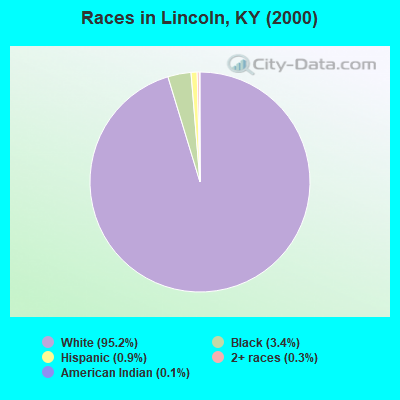
Races in Lincoln detailed stats: ancestries, foreign born residents, place of birth
 Recent articles from our blog. Our writers, many of them Ph.D. graduates or candidates, create easy-to-read articles on a wide variety of topics.
Current Local Time: CST time zone
Elevation: 920 feet
Land area: 105.7 square miles.
Population density: 14 people per square mile (very low).

| Lincoln CCD: | 0.4% ($199) |
| Kentucky: | 0.8% ($610) |
Nearest city with pop. 50,000+: Owensboro, KY  (61.4 miles , pop. 54,067).
Nearest city with pop. 200,000+: Louisville, KY (69.9 miles , pop. 256,231).
Nearest city with pop. 1,000,000+: Chicago, IL (325.6 miles , pop. 2,896,016).
Nearest cities:
), ), Latitude: 37.28 N, Longitude: 86.18 W
Area code commonly used in this area: 270

| Here: | 4.6% |
| Kentucky: | 3.8% |
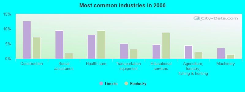
- Construction (12.7%)
- Social assistance (9.6%)
- Health care (8.1%)
- Transportation equipment (5.1%)
- Educational services (4.8%)
- Agriculture, forestry, fishing & hunting (4.4%)
- Machinery (3.6%)
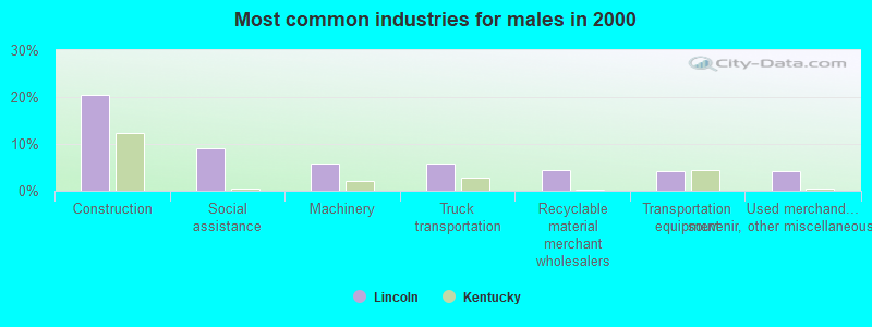
- Construction (20.5%)
- Social assistance (9.1%)
- Machinery (5.9%)
- Truck transportation (5.9%)
- Recyclable material merchant wholesalers (4.5%)
- Transportation equipment (4.3%)
- Used merchandise, gift, novelty, souvenir, other miscellaneous stores (4.3%)
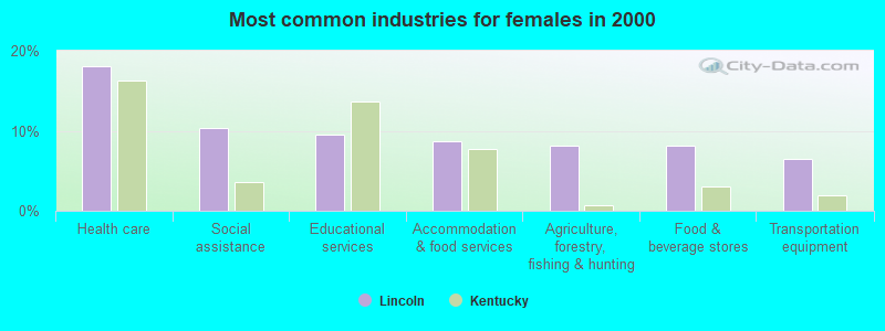
- Health care (18.1%)
- Social assistance (10.3%)
- Educational services (9.5%)
- Accommodation & food services (8.6%)
- Agriculture, forestry, fishing & hunting (8.2%)
- Food & beverage stores (8.2%)
- Transportation equipment (6.5%)
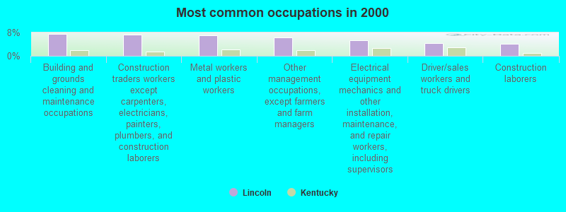
- Building and grounds cleaning and maintenance occupations (7.4%)
- Construction traders workers except carpenters, electricians, painters, plumbers, and construction laborers (7.2%)
- Metal workers and plastic workers (7.1%)
- Other management occupations, except farmers and farm managers (6.3%)
- Electrical equipment mechanics and other installation, maintenance, and repair workers, including supervisors (5.3%)
- Driver/sales workers and truck drivers (4.3%)
- Construction laborers (4.1%)
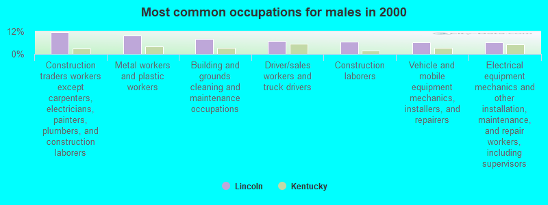
- Construction traders workers except carpenters, electricians, painters, plumbers, and construction laborers (11.7%)
- Metal workers and plastic workers (9.9%)
- Building and grounds cleaning and maintenance occupations (8.0%)
- Driver/sales workers and truck drivers (6.9%)
- Construction laborers (6.7%)
- Vehicle and mobile equipment mechanics, installers, and repairers (6.1%)
- Electrical equipment mechanics and other installation, maintenance, and repair workers, including supervisors (6.1%)
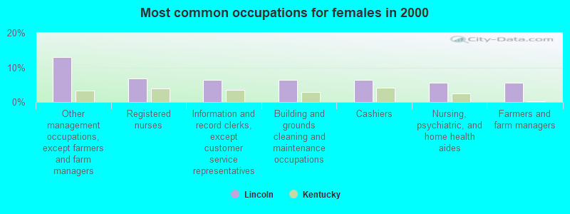
- Other management occupations, except farmers and farm managers (12.9%)
- Registered nurses (6.9%)
- Information and record clerks, except customer service representatives (6.5%)
- Building and grounds cleaning and maintenance occupations (6.5%)
- Cashiers (6.5%)
- Nursing, psychiatric, and home health aides (5.6%)
- Farmers and farm managers (5.6%)
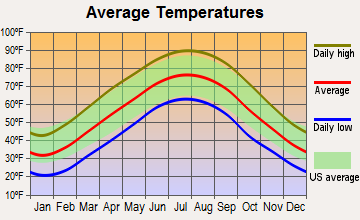
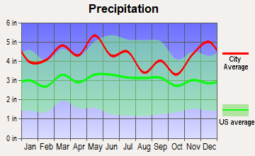
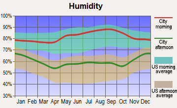
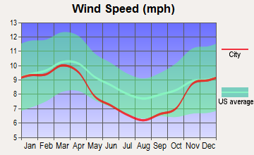
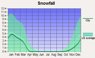
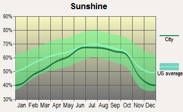
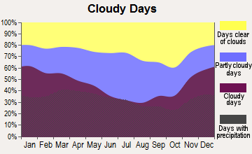
Average climate in Lincoln, Kentucky
Based on data reported by over 4,000 weather stations
(lower is better)
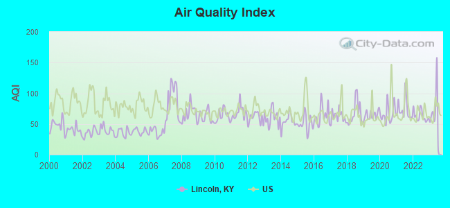
Air Quality Index (AQI) level in 2023 was 68.5. This is about average.
| City: | 68.5 |
| U.S.: | 72.6 |
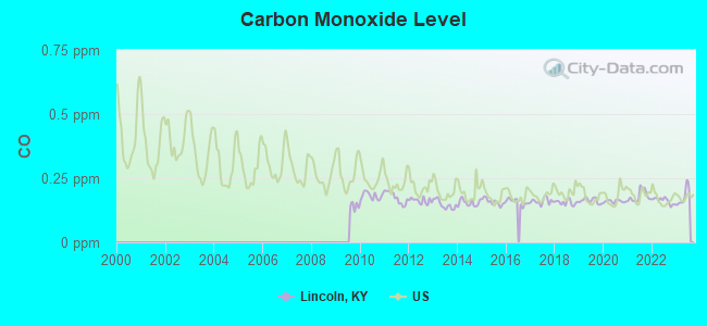
Carbon Monoxide (CO) [ppm] level in 2023 was 0.178. This is significantly better than average. Closest monitor was 10.2 miles away from the city center.
| City: | 0.178 |
| U.S.: | 0.251 |
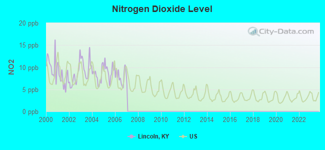
Nitrogen Dioxide (NO2) [ppb] level in 2006 was 7.91. This is significantly worse than average. Closest monitor was 15.4 miles away from the city center.
| City: | 7.91 |
| U.S.: | 5.11 |
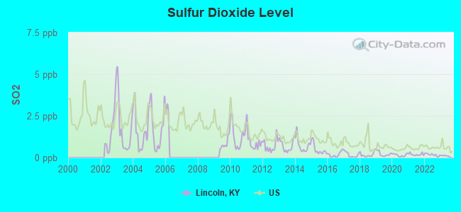
Sulfur Dioxide (SO2) [ppb] level in 2023 was 0.108. This is significantly better than average. Closest monitor was 7.8 miles away from the city center.
| City: | 0.108 |
| U.S.: | 1.515 |
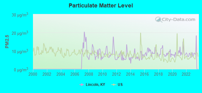
Particulate Matter (PM2.5) [µg/m3] level in 2022 was 7.68. This is about average. Closest monitor was 10.2 miles away from the city center.
| City: | 7.68 |
| U.S.: | 8.11 |
Tornado activity:
Lincoln-area historical tornado activity is slightly above Kentucky state average. It is 51% greater than the overall U.S. average.
On 4/3/1974, a category F4 (max. wind speeds 207-260 mph) tornado 17.6 miles away from the Lincoln place center injured 2 people.
On 4/3/1974, a category F5 (max. wind speeds 261-318 mph) tornado 36.8 miles away from the place center killed 31 people and injured 270 people and caused between $500,000 and $5,000,000 in damages.
Earthquake activity:
Lincoln-area historical earthquake activity is significantly above Kentucky state average. It is 154% greater than the overall U.S. average.On 4/18/2008 at 09:36:59, a magnitude 5.4 (5.1 MB, 4.8 MS, 5.4 MW, 5.2 MW, Class: Moderate, Intensity: VI - VII) earthquake occurred 123.7 miles away from the city center
On 4/18/2008 at 09:36:59, a magnitude 5.2 (5.2 MW, Depth: 8.9 mi) earthquake occurred 123.7 miles away from Lincoln center
On 7/27/1980 at 18:52:21, a magnitude 5.2 (5.1 MB, 4.7 MS, 5.0 UK, 5.2 UK) earthquake occurred 138.0 miles away from the city center
On 6/18/2002 at 17:37:15, a magnitude 5.0 (4.3 MB, 4.6 MW, 5.0 LG) earthquake occurred 100.6 miles away from the city center
On 6/10/1987 at 23:48:54, a magnitude 5.1 (4.9 MB, 4.4 MS, 4.6 MS, 5.1 LG) earthquake occurred 141.6 miles away from the city center
On 4/18/2008 at 15:14:16, a magnitude 4.8 (4.5 MB, 4.8 MW, 4.6 MW, Class: Light, Intensity: IV - V) earthquake occurred 123.2 miles away from Lincoln center
Magnitude types: regional Lg-wave magnitude (LG), body-wave magnitude (MB), surface-wave magnitude (MS), moment magnitude (MW)
Natural disasters:
The number of natural disasters in Edmonson County (16) is near the US average (15).Major Disasters (Presidential) Declared: 11
Emergencies Declared: 3
Causes of natural disasters: Floods: 10, Storms: 9, Mudslides: 4, Tornadoes: 4, Winter Storms: 4, Landslides: 2, Blizzard: 1, Freeze: 1, Hurricane: 1, Snow: 1, Snowfall: 1, Snowstorm: 1, Wind: 1, Other: 1 (Note: some incidents may be assigned to more than one category).
Hospitals and medical centers near Lincoln:
- EDMONSON CARE AND REHABILITATION CENTER (Nursing Home, about 8 miles away; BROWNSVILLE, KY)
- LEITCHFIELD DIALYSIS (Dialysis Facility, about 15 miles away; LEITCHFIELD, KY)
- TWIN LAKES REGIONAL MEDICAL CENTER Acute Care Hospitals (about 15 miles away; LEITCHFIELD, KY)
- TWIN LAKES HOME HEALTH (Home Health Center, about 15 miles away; LEITCHFIELD, KY)
Colleges/universities with over 2000 students nearest to Lincoln:
- Western Kentucky University (about 26 miles; Bowling Green, KY; Full-time enrollment: 16,942)
- Southcentral Kentucky Community and Technical College (about 27 miles; Bowling Green, KY; FT enrollment: 2,794)
- Elizabethtown Community and Technical College (about 35 miles; Elizabethtown, KY; FT enrollment: 3,762)
- Campbellsville University (about 46 miles; Campbellsville, KY; FT enrollment: 2,948)
- Lindsey Wilson College (about 50 miles; Columbia, KY; FT enrollment: 2,552)
- Owensboro Community and Technical College (about 59 miles; Owensboro, KY; FT enrollment: 2,754)
- Volunteer State Community College (about 66 miles; Gallatin, TN; FT enrollment: 5,311)
Points of interest:
Notable locations in Lincoln: Reeds Ferry (A), Laurel Ridge Camp (B), Maple Springs Group Campground (C), Houchins Ferry (D), Flint Ridge Ranger Station (E), Three Springs Pumphouse (F), Mount McKinley Pumphouse (G), Great Onyx Cave Pumphouse (H), Bransford Pumphouse (I), Wilderness Road (J), Adwell Pumphouse (K), Great Onyx Job Corps Center (L), Mammoth Cave Volunteer Fire Department (M), Lincoln Volunteer Fire Department (N). Display/hide their locations on the map
Churches in Lincoln include: Good Spring Church (A), Joppa Church (B), Mammoth Cave Baptist Church (C), Nolin Church (D), Stockholm Church (E), Union Light Church (F), Cove Hollow Church (G), Hill Grove Missionary Baptist Church (H). Display/hide their locations on the map
Cemeteries: Locust Grove Cemetery (1), Cove Hollow Cemetery (2), Adwell Cemetery (3), Woolsey Cemetery (4), Little Jordan Cemetery (5), Hill Grove Missionary Baptist Church Cemetery (6), Old Guides Cemetery (7). Display/hide their locations on the map
Lakes: First Creek Lake (A), Doyels Big Pond (B). Display/hide their locations on the map
Streams, rivers, and creeks: Dry Branch (A), Blair Spring Branch (B), Blowing Spring Branch (C), Brier Creek (D), Ugly Creek (E), Wolf Creek (F), River Styx (G), Bylew Creek (H), Buffalo Creek (I). Display/hide their locations on the map
Parks in Lincoln include: Nolin Lake State Park (1), Mammoth Cave National Park (2). Display/hide their locations on the map
| This place: | 2.4 people |
| Kentucky: | 2.5 people |
| This place: | 64.0% |
| Whole state: | 69.8% |
| This place: | 3.9% |
| Whole state: | 4.5% |
Likely homosexual households (counted as self-reported same-sex unmarried-partner households)
- Lesbian couples: 0.3% of all households
- Gay men: 0.0% of all households
| This place: | 18.3% |
| Whole state: | 15.8% |
| This place: | 10.7% |
| Whole state: | 6.6% |
For population 15 years and over in Lincoln:
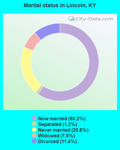
- Never married: 20.8%
- Now married: 60.2%
- Separated: 1.2%
- Widowed: 7.5%
- Divorced: 11.4%
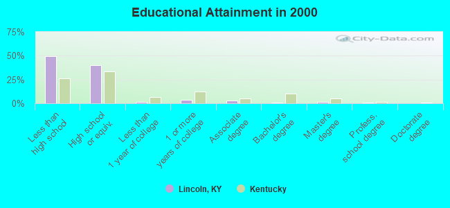
For population 25 years and over in Lincoln:
- High school or higher: 50.7%
- Bachelor's degree or higher: 2.8%
- Graduate or professional degree: 2.2%
- Unemployed: 3.7%
- Mean travel time to work (commute): 43.7 minutes
| Here: | 13.9 |
| Kentucky average: | 13.8 |
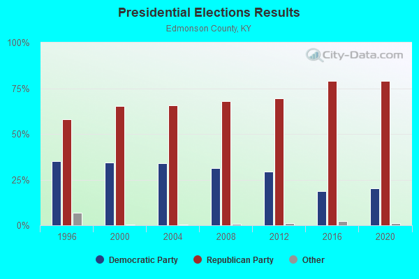
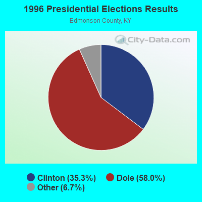

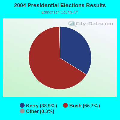

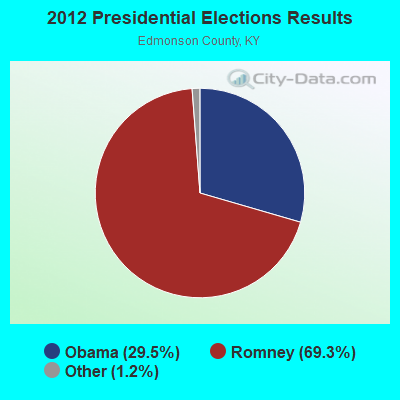
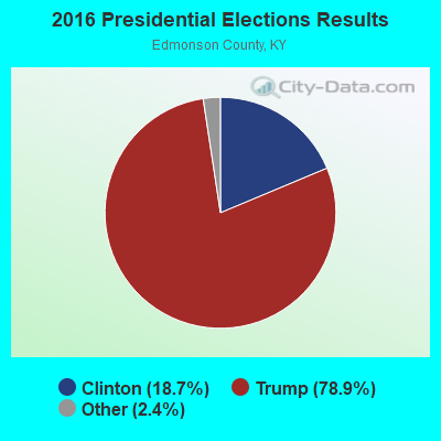
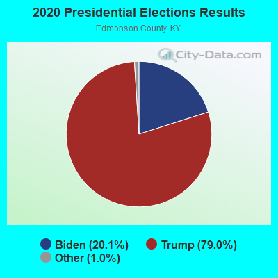
Graphs represent county-level data. Detailed 2008 Election Results
Religion statistics for Lincoln, KY (based on Edmonson County data)
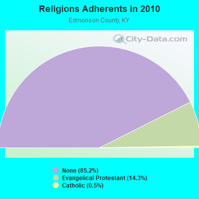
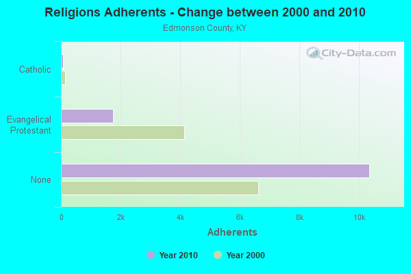
| Religion | Adherents | Congregations |
|---|---|---|
| Evangelical Protestant | 1,737 | 12 |
| Catholic | 63 | 1 |
| Mainline Protestant | - | - |
| None | 10,361 | - |
Food Environment Statistics:
| Here: | 4.18 / 10,000 pop. |
| Kentucky: | 2.19 / 10,000 pop. |
| Edmonson County: | 5.86 / 10,000 pop. |
| Kentucky: | 4.36 / 10,000 pop. |
| This county: | 5.02 / 10,000 pop. |
| Kentucky: | 5.74 / 10,000 pop. |
| This county: | 12.9% |
| Kentucky: | 11.0% |
| Edmonson County: | 32.3% |
| Kentucky: | 30.0% |
| Edmonson County: | 15.6% |
| Kentucky: | 15.9% |
Strongest AM radio stations in Lincoln:
- WKCT (930 AM; 5 kW; BOWLING GREEN, KY; Owner: DAILY NEWS BROADCASTING CO.)
- WHAS (840 AM; 50 kW; LOUISVILLE, KY; Owner: CLEAR CHANNEL BROADCASTING LICENSES, INC.)
- WSM (650 AM; 50 kW; NASHVILLE, TN; Owner: GAYLORD ENTERTAINMENT COMPANY)
- WAMB (1160 AM; 50 kW; DONELSON, TN; Owner: GREAT SOUTHERN BROADCASTING COMPANY, INC.)
- WKDA (1200 AM; 50 kW; NASHVILLE, TN; Owner: RADIO NASHVILLE, INC.)
- WLAC (1510 AM; 50 kW; NASHVILLE, TN; Owner: CAPSTAR TX LIMITED PARTNERSHIP)
- WNQM (1300 AM; 50 kW; NASHVILLE, TN; Owner: WNQM. INC.)
- WLOC (1150 AM; 1 kW; MUNFORDVILLE, KY; Owner: HART COUNTY COMMUNICATIONS, INC.)
- WKVL (850 AM; daytime; 50 kW; KNOXVILLE, TN; Owner: HORNE RADIO, LLC)
- WWAM (820 AM; daytime; 50 kW; JASPER, TN; Owner: SHELTON BROADCASTING SYSTEM)
- WLW (700 AM; 50 kW; CINCINNATI, OH; Owner: JACOR BROADCASTING CORPORATION)
- WMTL (870 AM; daytime; 0 kW; LEITCHFIELD, KY; Owner: HERITAGE MEDIA OF KENTUCKY INC)
- WPLN (1430 AM; 15 kW; MADISON, TN)
Strongest FM radio stations in Lincoln:
- WKLX (100.7 FM; BROWNSVILLE, KY; Owner: CHARLES M. ANDERSON)
- WGGC (95.1 FM; GLASGOW, KY; Owner: HERITAGE COMMUNICATIONS, INC.)
- WJCR-FM (90.1 FM; UPTON, KY; Owner: FM 90.1, INC.)
- WHHT (106.7 FM; HORSE CAVE, KY; Owner: NEWBERRY BROADCASTING, INC.)
- WPTQ (103.7 FM; CAVE CITY, KY; Owner: NEWBERRY BROADCASTING, INC.)
- WUHU (107.1 FM; SMITHS GROVE, KY; Owner: FOREVER COMMUNICATIONS INC)
- WCLU-FM (102.3 FM; MUNFORDVILLE, KY; Owner: ROYSE RADIO, INC)
- WKYU-FM (88.9 FM; BOWLING GREEN, KY; Owner: WESTERN KENTUCKY UNIVERSITY)
- WDNS (93.3 FM; BOWLING GREEN, KY; Owner: DAILY NEWS BROADCASTING COMPANY)
- WUBT (101.1 FM; RUSSELLVILLE, KY; Owner: CAPSTAR TX LIMITED PARTNERSHIP)
- WKHG (104.9 FM; LEITCHFIELD, KY; Owner: HERITAGE MEDIA OF KENTUCKY INC)
- WASE (103.5 FM; RADCLIFF, KY; Owner: W & B BROADCASTING, INC.)
- WCVK (90.7 FM; BOWLING GREEN, KY; Owner: BOWLING GREEN COMMTY. B/CSTG, INC.)
- WBVR-FM (96.7 FM; AUBURN, KY; Owner: FOREVER COMMUNICATIONS INC)
- WWHR (91.7 FM; BOWLING GREEN, KY; Owner: WESTERN KENTUCKY UNIVERSITY)
- WBFI (91.5 FM; MCDANIELS, KY; Owner: BETHEL FELLOWSHIP, INC.)
TV broadcast stations around Lincoln:
- WNKY (Channel 40; BOWLING GREEN, KY; Owner: MMK LICENSE LLC)
- WBKO (Channel 13; BOWLING GREEN, KY; Owner: GRAY MIDAMERICA TV LICENSEE CORP.)
- W62CJ (Channel 62; JACKSON, TN; Owner: MS COMMUNICATIONS, LLC)
- WKYU-TV (Channel 24; BOWLING GREEN, KY; Owner: WESTERN KENTUCKY UNIVERSITY)
- WBKI-TV (Channel 34; CAMPBELLSVILLE, KY; Owner: LOUISVILLE COMMUNICATIONS, LLC)
- WKGB-TV (Channel 53; BOWLING GREEN, KY; Owner: KENTUCKY AUTHORITY FOR EDUCATIONAL TV)
- WKZT-TV (Channel 23; ELIZABETHTOWN, KY; Owner: KENTUCKY AUTHORITY FOR EDUCATIONAL TV)
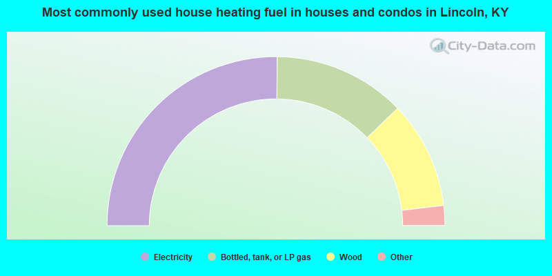
- 50.2%Electricity
- 25.3%Bottled, tank, or LP gas
- 20.6%Wood
- 2.6%Fuel oil, kerosene, etc.
- 1.2%Utility gas
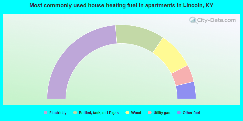
- 47.3%Electricity
- 21.5%Bottled, tank, or LP gas
- 16.1%Wood
- 7.5%Utility gas
- 7.5%Other fuel
Lincoln compared to Kentucky state average:
- Median house value below state average.
- Unemployed percentage significantly below state average.
- Black race population percentage below state average.
- Hispanic race population percentage significantly below state average.
- Foreign-born population percentage significantly below state average.
- Renting percentage significantly below state average.
- Length of stay since moving in significantly above state average.
- Number of rooms per house significantly below state average.
- House age significantly below state average.
- Number of college students below state average.
- Percentage of population with a bachelor's degree or higher significantly below state average.
Lincoln on our top lists:
- #15 on the list of "Top 101 cities with the largest percentage of people in other nonhousehold living situations (population 1,000+)"
- #38 on the list of "Top 101 counties with the highest carbon monoxide air pollution readings in 2012 (ppm)"