Millerstown, Kentucky
Submit your own pictures of this place and show them to the world
- OSM Map
- General Map
- Google Map
- MSN Map

| Males: 1,404 | |
| Females: 1,344 |
| Median resident age: | 41.2 years |
| Kentucky median age: | 35.9 years |
Zip code: 42726
| Millerstown: | $43,877 |
| KY: | $59,341 |
Estimated per capita income in 2022: $24,857 (it was $14,154 in 2000)
Millerstown CCD income, earnings, and wages data
Estimated median house or condo value in 2022: $151,200 (it was $60,700 in 2000)
| Millerstown: | $151,200 |
| KY: | $196,300 |
Mean prices in 2022: all housing units: $191,356; detached houses: $213,828; townhouses or other attached units: $160,800; in 2-unit structures: $126,712; mobile homes: $63,683
Detailed information about poverty and poor residents in Millerstown, KY


- 2,56898.1%White alone
- 291.1%Hispanic
- 130.5%Two or more races
- 50.2%American Indian alone
- 10.04%Black alone
- 10.04%Asian alone
- 10.04%Native Hawaiian and Other
Pacific Islander alone - 10.04%Other race alone

Races in Millerstown detailed stats: ancestries, foreign born residents, place of birth
 Recent articles from our blog. Our writers, many of them Ph.D. graduates or candidates, create easy-to-read articles on a wide variety of topics.
Current Local Time: CST time zone
Elevation: 589 feet
Land area: 80.0 square miles.
Population density: 34 people per square mile (very low).

| Millerstown CCD: | 0.5% ($302) |
| Kentucky: | 0.8% ($610) |
Nearest city with pop. 50,000+: Owensboro, KY  (59.6 miles , pop. 54,067).
Nearest city with pop. 200,000+: Louisville, KY (61.8 miles , pop. 256,231).
Nearest city with pop. 1,000,000+: Chicago, IL (318.7 miles , pop. 2,896,016).
Nearest cities:
), ), )Latitude: 37.39 N, Longitude: 86.14 W
Area code commonly used in this area: 270


| Here: | 4.2% |
| Kentucky: | 3.8% |

- Construction (16.6%)
- Educational services (8.3%)
- Metal & metal products (7.9%)
- Machinery (4.3%)
- Health care (4.2%)
- Food & beverage stores (4.1%)
- Agriculture, forestry, fishing & hunting (3.8%)

- Construction (28.9%)
- Metal & metal products (10.8%)
- Agriculture, forestry, fishing & hunting (5.6%)
- Motor vehicle & parts dealers (4.3%)
- Machinery (3.5%)
- Furniture & related product manufacturing (3.3%)
- Accommodation & food services (3.3%)

- Educational services (16.5%)
- Health care (9.4%)
- Food & beverage stores (8.1%)
- Public administration (6.5%)
- Machinery (5.2%)
- Food (4.4%)
- Accommodation & food services (4.4%)

- Other production occupations, including supervisors (10.5%)
- Metal workers and plastic workers (5.0%)
- Building and grounds cleaning and maintenance occupations (4.8%)
- Assemblers and fabricators (4.6%)
- Laborers and material movers, hand (4.3%)
- Electrical equipment mechanics and other installation, maintenance, and repair workers, including supervisors (4.2%)
- Material recording, scheduling, dispatching, and distributing workers (4.0%)

- Other production occupations, including supervisors (10.8%)
- Metal workers and plastic workers (7.5%)
- Supervisors, construction and extraction workers (7.0%)
- Construction laborers (7.0%)
- Electrical equipment mechanics and other installation, maintenance, and repair workers, including supervisors (6.3%)
- Building and grounds cleaning and maintenance occupations (5.3%)
- Carpenters (5.3%)

- Other production occupations, including supervisors (10.0%)
- Cashiers (5.6%)
- Secretaries and administrative assistants (5.4%)
- Preschool, kindergarten, elementary, and middle school teachers (5.2%)
- Material recording, scheduling, dispatching, and distributing workers (4.4%)
- Financial clerks, except bookkeeping, accounting and auditing clerks (4.2%)
- Building and grounds cleaning and maintenance occupations (4.2%)
Average climate in Millerstown, Kentucky
Based on data reported by over 4,000 weather stations


(lower is better)

Air Quality Index (AQI) level in 2023 was 68.5. This is about average.
| City: | 68.5 |
| U.S.: | 72.6 |

Carbon Monoxide (CO) [ppm] level in 2023 was 0.178. This is significantly better than average. Closest monitor was 17.8 miles away from the city center.
| City: | 0.178 |
| U.S.: | 0.251 |

Sulfur Dioxide (SO2) [ppb] level in 2023 was 0.108. This is significantly better than average. Closest monitor was 10.5 miles away from the city center.
| City: | 0.108 |
| U.S.: | 1.515 |


Particulate Matter (PM2.5) [µg/m3] level in 2022 was 7.68. This is about average. Closest monitor was 17.8 miles away from the city center.
| City: | 7.68 |
| U.S.: | 8.11 |
Tornado activity:
Millerstown-area historical tornado activity is slightly above Kentucky state average. It is 51% greater than the overall U.S. average.
On 4/3/1974, a category F4 (max. wind speeds 207-260 mph) tornado 13.2 miles away from the Millerstown place center injured 2 people.
On 4/3/1974, a category F5 (max. wind speeds 261-318 mph) tornado 32.0 miles away from the place center killed 31 people and injured 270 people and caused between $500,000 and $5,000,000 in damages.
Earthquake activity:
Millerstown-area historical earthquake activity is significantly above Kentucky state average. It is 150% greater than the overall U.S. average.On 4/18/2008 at 09:36:59, a magnitude 5.4 (5.1 MB, 4.8 MS, 5.4 MW, 5.2 MW, Class: Moderate, Intensity: VI - VII) earthquake occurred 120.5 miles away from the city center
On 4/18/2008 at 09:36:59, a magnitude 5.2 (5.2 MW, Depth: 8.9 mi) earthquake occurred 120.5 miles away from Millerstown center
On 7/27/1980 at 18:52:21, a magnitude 5.2 (5.1 MB, 4.7 MS, 5.0 UK, 5.2 UK) earthquake occurred 132.4 miles away from the city center
On 6/18/2002 at 17:37:15, a magnitude 5.0 (4.3 MB, 4.6 MW, 5.0 LG) earthquake occurred 99.1 miles away from the city center
On 6/10/1987 at 23:48:54, a magnitude 5.1 (4.9 MB, 4.4 MS, 4.6 MS, 5.1 LG) earthquake occurred 137.4 miles away from the city center
On 4/18/2008 at 15:14:16, a magnitude 4.8 (4.5 MB, 4.8 MW, 4.6 MW, Class: Light, Intensity: IV - V) earthquake occurred 119.9 miles away from the city center
Magnitude types: regional Lg-wave magnitude (LG), body-wave magnitude (MB), surface-wave magnitude (MS), moment magnitude (MW)
Natural disasters:
The number of natural disasters in Grayson County (20) is greater than the US average (15).Major Disasters (Presidential) Declared: 17
Emergencies Declared: 2
Causes of natural disasters: Floods: 12, Storms: 12, Tornadoes: 9, Winter Storms: 4, Mudslides: 3, Snows: 2, Winds: 2, Blizzard: 1, Freeze: 1, Hurricane: 1, Other: 1 (Note: some incidents may be assigned to more than one category).
Hospitals and medical centers near Millerstown:
- LEITCHFIELD DIALYSIS (Dialysis Facility, about 11 miles away; LEITCHFIELD, KY)
- TWIN LAKES REGIONAL MEDICAL CENTER Acute Care Hospitals (about 11 miles away; LEITCHFIELD, KY)
- TWIN LAKES HOME HEALTH (Home Health Center, about 11 miles away; LEITCHFIELD, KY)
- EDMONSON CARE AND REHABILITATION CENTER (Nursing Home, about 16 miles away; BROWNSVILLE, KY)
Colleges/universities with over 2000 students nearest to Millerstown:
- Elizabethtown Community and Technical College (about 27 miles; Elizabethtown, KY; Full-time enrollment: 3,762)
- Western Kentucky University (about 34 miles; Bowling Green, KY; FT enrollment: 16,942)
- Southcentral Kentucky Community and Technical College (about 34 miles; Bowling Green, KY; FT enrollment: 2,794)
- Campbellsville University (about 44 miles; Campbellsville, KY; FT enrollment: 2,948)
- Lindsey Wilson College (about 51 miles; Columbia, KY; FT enrollment: 2,552)
- Owensboro Community and Technical College (about 57 miles; Owensboro, KY; FT enrollment: 2,754)
- University of Louisville (about 61 miles; Louisville, KY; FT enrollment: 16,640)
Points of interest:
Notable location: Wax Fire Department (A). Display/hide its location on the map
Churches in Millerstown include: Little Flock Church (A), Mount Moriah Church (B), Mount Zion Church (C), Oak Grove Church (D), Pleasant Valley Church (E), Sulphur Wells Church (F), Saint Benedicts Catholic Church (G), Broad Ford Church (H). Display/hide their locations on the map
Cemetery: Logsdon Cemetery (1). Display/hide its location on the map
Reservoir: Nichols Lake (A). Display/hide its location on the map
Streams, rivers, and creeks: Dry Run (A), Barton Run (B), Berry Run (C), Slab Camp Creek (D), Sinking Fork (E), Nosey Creek (F), Laurel Run (G), Hunting Fork (H), Rock Creek (I). Display/hide their locations on the map
| This place: | 2.5 people |
| Kentucky: | 2.5 people |
| This place: | 74.6% |
| Whole state: | 66.9% |
| This place: | 4.7% |
| Whole state: | 6.4% |
Likely homosexual households (counted as self-reported same-sex unmarried-partner households)
- Lesbian couples: 0.4% of all households
- Gay men: 0.2% of all households
| This place: | 12.9% |
| Whole state: | 15.8% |
| This place: | 6.5% |
| Whole state: | 6.6% |
For population 15 years and over in Millerstown:

- Never married: 11.9%
- Now married: 70.5%
- Separated: 0.8%
- Widowed: 6.9%
- Divorced: 10.7%
For population 25 years and over in Millerstown:
- High school or higher: 65.1%
- Bachelor's degree or higher: 4.8%
- Graduate or professional degree: 1.9%
- Unemployed: 4.1%
- Mean travel time to work (commute): 35.4 minutes


| Here: | 13.4 |
| Kentucky average: | 13.8 |
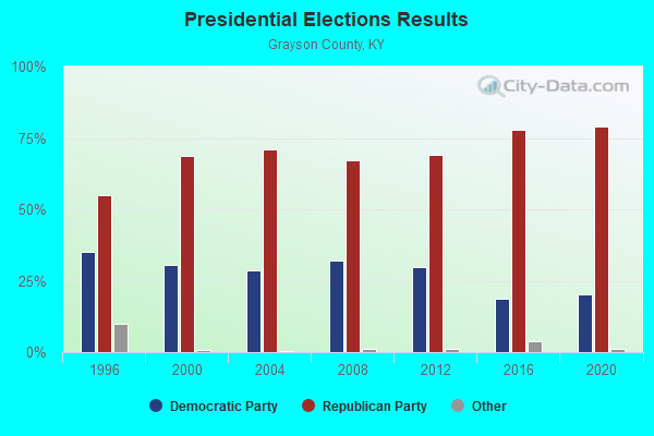
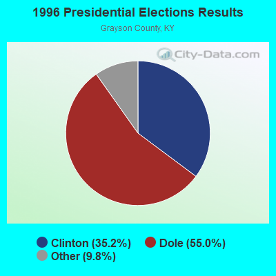


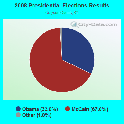
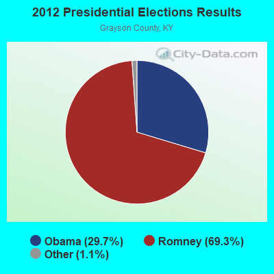
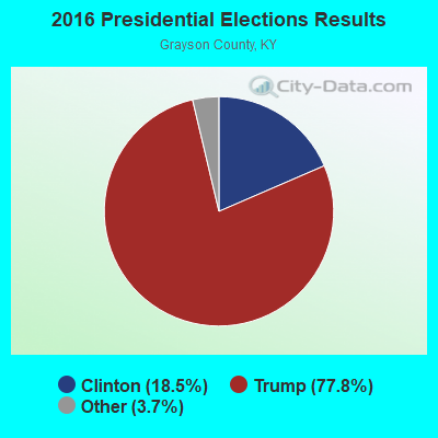
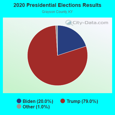
Graphs represent county-level data. Detailed 2008 Election Results
Religion statistics for Millerstown, KY (based on Grayson County data)
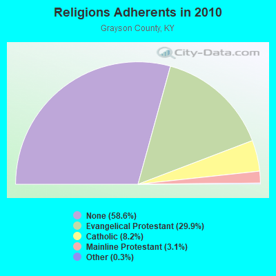
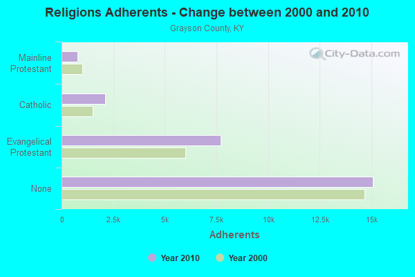
| Religion | Adherents | Congregations |
|---|---|---|
| Evangelical Protestant | 7,693 | 50 |
| Catholic | 2,100 | 6 |
| Mainline Protestant | 787 | 8 |
| Other | 77 | 1 |
| None | 15,089 | - |
Food Environment Statistics:
| Grayson County: | 3.56 / 10,000 pop. |
| State: | 2.19 / 10,000 pop. |
| Grayson County: | 0.40 / 10,000 pop. |
| State: | 0.25 / 10,000 pop. |
| This county: | 1.98 / 10,000 pop. |
| Kentucky: | 0.74 / 10,000 pop. |
| This county: | 7.11 / 10,000 pop. |
| Kentucky: | 4.36 / 10,000 pop. |
| Here: | 3.56 / 10,000 pop. |
| Kentucky: | 5.74 / 10,000 pop. |
| Grayson County: | 12.2% |
| Kentucky: | 11.0% |
| Grayson County: | 28.5% |
| Kentucky: | 30.0% |
| Grayson County: | 15.1% |
| Kentucky: | 15.9% |
Strongest AM radio stations in Millerstown:
- WHAS (840 AM; 50 kW; LOUISVILLE, KY; Owner: CLEAR CHANNEL BROADCASTING LICENSES, INC.)
- WSM (650 AM; 50 kW; NASHVILLE, TN; Owner: GAYLORD ENTERTAINMENT COMPANY)
- WKCT (930 AM; 5 kW; BOWLING GREEN, KY; Owner: DAILY NEWS BROADCASTING CO.)
- WAMB (1160 AM; 50 kW; DONELSON, TN; Owner: GREAT SOUTHERN BROADCASTING COMPANY, INC.)
- WKDA (1200 AM; 50 kW; NASHVILLE, TN; Owner: RADIO NASHVILLE, INC.)
- WLAC (1510 AM; 50 kW; NASHVILLE, TN; Owner: CAPSTAR TX LIMITED PARTNERSHIP)
- WNQM (1300 AM; 50 kW; NASHVILLE, TN; Owner: WNQM. INC.)
- WLOC (1150 AM; 1 kW; MUNFORDVILLE, KY; Owner: HART COUNTY COMMUNICATIONS, INC.)
- WMTL (870 AM; daytime; 0 kW; LEITCHFIELD, KY; Owner: HERITAGE MEDIA OF KENTUCKY INC)
- WKVL (850 AM; daytime; 50 kW; KNOXVILLE, TN; Owner: HORNE RADIO, LLC)
- WLW (700 AM; 50 kW; CINCINNATI, OH; Owner: JACOR BROADCASTING CORPORATION)
- WWAM (820 AM; daytime; 50 kW; JASPER, TN; Owner: SHELTON BROADCASTING SYSTEM)
- WKJK (1080 AM; 10 kW; LOUISVILLE, KY; Owner: CLEAR CHANNEL BROADCASTING LICENSES, INC.)
Strongest FM radio stations in Millerstown:
- WJCR-FM (90.1 FM; UPTON, KY; Owner: FM 90.1, INC.)
- WKLX (100.7 FM; BROWNSVILLE, KY; Owner: CHARLES M. ANDERSON)
- WKHG (104.9 FM; LEITCHFIELD, KY; Owner: HERITAGE MEDIA OF KENTUCKY INC)
- WGGC (95.1 FM; GLASGOW, KY; Owner: HERITAGE COMMUNICATIONS, INC.)
- WHHT (106.7 FM; HORSE CAVE, KY; Owner: NEWBERRY BROADCASTING, INC.)
- WCLU-FM (102.3 FM; MUNFORDVILLE, KY; Owner: ROYSE RADIO, INC)
- WASE (103.5 FM; RADCLIFF, KY; Owner: W & B BROADCASTING, INC.)
- WPTQ (103.7 FM; CAVE CITY, KY; Owner: NEWBERRY BROADCASTING, INC.)
- WKUE (90.9 FM; ELIZABETHTOWN, KY; Owner: WESTERN KENTUCKY UNIVERSITY)
- WQXE (98.3 FM; ELIZABETHTOWN, KY; Owner: SKYTOWER COMMUNICATIONS-E'TOWN, INC.)
- WKYU-FM (88.9 FM; BOWLING GREEN, KY; Owner: WESTERN KENTUCKY UNIVERSITY)
- WUHU (107.1 FM; SMITHS GROVE, KY; Owner: FOREVER COMMUNICATIONS INC)
- WBFI (91.5 FM; MCDANIELS, KY; Owner: BETHEL FELLOWSHIP, INC.)
- WLVK (105.5 FM; FORT KNOX, KY; Owner: BIG CAT BROADCASTING, INC.)
- WRZI (101.5 FM; VINE GROVE, KY; Owner: ELIZABETHTOWN CBC, INC.)
TV broadcast stations around Millerstown:
- WKZT-TV (Channel 23; ELIZABETHTOWN, KY; Owner: KENTUCKY AUTHORITY FOR EDUCATIONAL TV)
- WBKI-TV (Channel 34; CAMPBELLSVILLE, KY; Owner: LOUISVILLE COMMUNICATIONS, LLC)
- W62CJ (Channel 62; JACKSON, TN; Owner: MS COMMUNICATIONS, LLC)
- WBKO (Channel 13; BOWLING GREEN, KY; Owner: GRAY MIDAMERICA TV LICENSEE CORP.)
- WNKY (Channel 40; BOWLING GREEN, KY; Owner: MMK LICENSE LLC)
- WKYU-TV (Channel 24; BOWLING GREEN, KY; Owner: WESTERN KENTUCKY UNIVERSITY)
- W39CJ (Channel 39; ELIZABETHTOWN, KY; Owner: TRINITY BROADCASTING NETWORK)
- WKGB-TV (Channel 53; BOWLING GREEN, KY; Owner: KENTUCKY AUTHORITY FOR EDUCATIONAL TV)
FCC Registered Antenna Towers:
1- 13101 Raider Hollow Road (Lat: 37.432778 Lon: -86.030278), Type: 124.0, Overall height: 122.3 m, Registrant: Fm 90.1, Inc., Upton, Phone: (502) 369-8614

- 51.4%Electricity
- 34.6%Bottled, tank, or LP gas
- 10.3%Wood
- 1.9%Fuel oil, kerosene, etc.
- 1.2%Utility gas
- 0.7%No fuel used

- 31.4%Bottled, tank, or LP gas
- 31.4%Electricity
- 17.1%Fuel oil, kerosene, etc.
- 12.9%Wood
- 7.1%Utility gas
Millerstown compared to Kentucky state average:
- Unemployed percentage significantly below state average.
- Black race population percentage significantly below state average.
- Hispanic race population percentage significantly below state average.
- Foreign-born population percentage significantly below state average.
- Renting percentage significantly below state average.
- Length of stay since moving in significantly above state average.
- Number of rooms per house significantly below state average.
- House age significantly below state average.
- Number of college students below state average.
- Percentage of population with a bachelor's degree or higher significantly below state average.