Marionville, Missouri
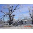
Marionville: THIS IS A PICTURE TAKEN DURING THE JAN. ICE STORM. POWER WAS OUT FOR MORE THAN 9 DAYS STRAIGHT IN MARIONVILLE
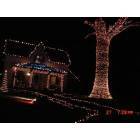
Marionville: this a house that decorates in marionville every year for halloween and also xmas. this was taken oct. 2006
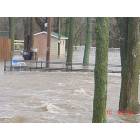
Marionville: This is a picture of the Marionville City Park taken on April, 4th, 2008 It shows the flood waters after a torrential rains
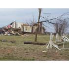
Marionville: this is a picture taken after the march 12th 06 tornado in marionville mo.
- add
your
Submit your own pictures of this city and show them to the world
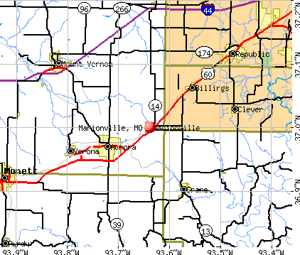
- OSM Map
- General Map
- Google Map
- MSN Map
Population change since 2000: -1.4%
 |
| Males: 968 | |
| Females: 1,116 |
| Median resident age: | 29.8 years |
| Missouri median age: | 39.1 years |
Zip codes: 65705.
| Marionville: | $46,757 |
| MO: | $64,811 |
Estimated per capita income in 2022: $20,983 (it was $13,552 in 2000)
Marionville city income, earnings, and wages data
Estimated median house or condo value in 2022: $131,455 (it was $53,200 in 2000)
| Marionville: | $131,455 |
| MO: | $221,200 |
Mean prices in 2022: all housing units: $126,427; detached houses: $137,326; mobile homes: $28,196
Median gross rent in 2022: $828.
(12.9% for White Non-Hispanic residents, 68.5% for Hispanic or Latino residents, 39.8% for two or more races residents)
Detailed information about poverty and poor residents in Marionville, MO


Compare current foreclosures near Marionville, MO:
| Photo | Address | Area | Beds / Baths | Price | Details |
|---|---|---|---|---|---|

|
#1
N Central Ave
Marionville, MO 65705
|
1,659 sq. feet
|
1 baths 3 beds |
show details | |

|
#2
N Melody Ln
Marionville, MO 65705
|
1,062 sq. feet
|
1 baths 3 beds |
show details | |

|
#3
W Odell
Marionville, MO 65705
|
1,472 sq. feet
|
1 baths 1 beds |
show details | |

|
#4
Lawrence 2185
Marionville, MO 65705
|
1,372 sq. feet
|
1 baths - beds |
show details | |

|
#5
Holt Spring Rd
Marionville, MO 65705
|
- sq. feet
|
- baths - beds |
show details | |

|
#6
Lawrence 1225
Marionville, MO 65705
|
- sq. feet
|
- baths - beds |
show details | |

|
#7
S Apple Ln
Marionville, MO 65705
|
- sq. feet
|
- baths - beds |
show details | |

|
#8
S Apple Ln
Marionville, MO 65705
|
- sq. feet
|
- baths - beds |
show details | |

|
#9
Lawrence 1247
Marionville, MO 65705
|
- sq. feet
|
- baths - beds |
show details | |

|
#10
N George Ave
Republic, MO 65738
|
2,280 sq. feet
|
2 baths 4 beds |
show details |
| Photo | Address | Area | Beds / Baths | Price | Details |
|---|---|---|---|---|---|

|
#11
State Highway M
Billings, MO 65610
|
1,344 sq. feet
|
1 baths 2 beds |
show details | |

|
#12
S Allen Ave
Republic, MO 65738
|
1,404 sq. feet
|
1 baths 3 beds |
show details | |

|
#13
Ethan Avenue
Republic, MO 65738
|
1,202 sq. feet
|
2 baths 3 beds |
show details | |

|
#14
E Cofield St
Aurora, MO 65605
|
628 sq. feet
|
1 baths 2 beds |
show details | |

|
#15
S Westwood Dr
Republic, MO 65738
|
1,652 sq. feet
|
2 baths 3 beds |
show details | |

|
#16
E Lee St
Republic, MO 65738
|
3,046 sq. feet
|
3 baths 4 beds |
show details | |

|
#17
Moonlight St
Republic, MO 65738
|
1,456 sq. feet
|
2 baths 3 beds |
show details | |

|
#18
E Jewell Dr
Republic, MO 65738
|
1,636 sq. feet
|
2 baths 3 beds |
show details | |

|
#19
S Hampton Ave
Republic, MO 65738
|
1,624 sq. feet
|
2 baths 3 beds |
show details | |

|
#20
Fillmore St
Mount Vernon, MO 65712
|
1,040 sq. feet
|
1 baths 3 beds |
show details |
| Photo | Address | Area | Beds / Baths | Price | Details |
|---|---|---|---|---|---|

|
#21
W State Route 266
Bois D Arc, MO 65612
|
1,044 sq. feet
|
1 baths 3 beds |
show details | |

|
#22
W Grant St
Republic, MO 65738
|
1,750 sq. feet
|
2 baths 3 beds |
show details | |

|
#23
W Jewell Dr
Republic, MO 65738
|
1,786 sq. feet
|
2 baths 3 beds |
show details | |

|
#24
N Pine Ave
Republic, MO 65738
|
1,864 sq. feet
|
2 baths 3 beds |
show details | |

|
#25
S Market St
Mount Vernon, MO 65712
|
2,104 sq. feet
|
2 baths 3 beds |
show details | |

|
#26
N Basswood Ave
Republic, MO 65738
|
1,404 sq. feet
|
2 baths 3 beds |
show details | |

|
#27
Lawrence 1112
Mount Vernon, MO 65712
|
1,500 sq. feet
|
2 baths 3 beds |
show details | |

|
#28
S West St
Mount Vernon, MO 65712
|
1,288 sq. feet
|
1 baths 2 beds |
show details | |

|
#29
E Donna St
Republic, MO 65738
|
1,398 sq. feet
|
2 baths 3 beds |
show details | |

|
#30
E Hines St
Republic, MO 65738
|
1,467 sq. feet
|
1 baths 3 beds |
show details |
| Photo | Address | Area | Beds / Baths | Price | Details |
|---|---|---|---|---|---|

|
#31
E Sandelwood St
Republic, MO 65738
|
1,180 sq. feet
|
2 baths 3 beds |
show details | |

|
#32
Wood St
Mount Vernon, MO 65712
|
1,324 sq. feet
|
2 baths 3 beds |
show details | |

|
#33
E Primrose St
Republic, MO 65738
|
1,254 sq. feet
|
2 baths 3 beds |
show details | |

|
#34
E Primrose St
Republic, MO 65738
|
1,131 sq. feet
|
2 baths 2 beds |
show details | |

|
#35
S Teakwood Ave
Republic, MO 65738
|
2,500 sq. feet
|
3 baths 4 beds |
show details | |

|
#36
E Kay St
Republic, MO 65738
|
1,060 sq. feet
|
1 baths 2 beds |
show details | |

|
#37
E Sequoia St
Republic, MO 65738
|
2,068 sq. feet
|
3 baths 4 beds |
show details | |

|
#38
E Kay St
Republic, MO 65738
|
1,594 sq. feet
|
2 baths 3 beds |
show details | |

|
#39
N Texas Ave
Republic, MO 65738
|
1,221 sq. feet
|
2 baths 3 beds |
show details | |

|
#40
S Carnation Dr
Aurora, MO 65605
|
1,348 sq. feet
|
1 baths 2 beds |
show details |
| Photo | Address | Area | Beds / Baths | Price | Details |
|---|---|---|---|---|---|

|
#41
W Plumb St
Aurora, MO 65605
|
1,456 sq. feet
|
1 baths 3 beds |
show details | |

|
#42
S Fieldstone Rd
Brookline Station, MO 65619
|
1,470 sq. feet
|
2 baths 3 beds |
show details | |

|
#43
N Mayberry Ave
Republic, MO 65738
|
1,190 sq. feet
|
2 baths 3 beds |
show details | |

|
#44
S Lincoln Ave
Aurora, MO 65605
|
800 sq. feet
|
1 baths 2 beds |
show details | |

|
#45
N Central Ave
Monett, MO 65708
|
1,900 sq. feet
|
1 baths 3 beds |
show details | |

|
#46
Brookside Cir
Monett, MO 65708
|
1,018 sq. feet
|
3 baths 3 beds |
show details | |

|
#47
Pin Oak Ln
Billings, MO 65610
|
- sq. feet
|
2 baths 3 beds |
show details | |

|
#48
Lawrence 2194
Monett, MO 65708
|
768 sq. feet
|
2 baths 3 beds |
show details | |

|
#49
W Farm Road 188
Republic, MO 65738
|
1,660 sq. feet
|
2 baths 3 beds |
show details | |

|
Check over 1 million property listings on Foreclosure.com!
|
browse all offers | |||


- 2,25988.2%White alone
- 2058.0%Hispanic
- 592.3%Two or more races
- 271.1%American Indian alone
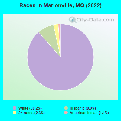
Races in Marionville detailed stats: ancestries, foreign born residents, place of birth
According to our research of Missouri and other state lists, there were 13 registered sex offenders living in Marionville, Missouri as of May 22, 2024.
The ratio of all residents to sex offenders in Marionville is 178 to 1.
Type |
2009 |
2010 |
2011 |
2012 |
2013 |
2014 |
2015 |
2016 |
2017 |
2018 |
2019 |
2020 |
2021 |
2022 |
|---|---|---|---|---|---|---|---|---|---|---|---|---|---|---|
| Murders (per 100,000) | 1 (45.8) | 0 (0.0) | 0 (0.0) | 0 (0.0) | 0 (0.0) | 0 (0.0) | 0 (0.0) | 0 (0.0) | 0 (0.0) | 0 (0.0) | 1 (45.9) | 0 (0.0) | 1 (46.4) | 0 (0.0) |
| Rapes (per 100,000) | 0 (0.0) | 0 (0.0) | 1 (44.8) | 1 (44.8) | 0 (0.0) | 1 (45.7) | 1 (46.0) | 1 (45.9) | 2 (91.2) | 4 (183.0) | 3 (137.8) | 1 (46.0) | 3 (139.1) | 1 (48.1) |
| Robberies (per 100,000) | 0 (0.0) | 0 (0.0) | 1 (44.8) | 1 (44.8) | 1 (45.3) | 0 (0.0) | 0 (0.0) | 2 (91.7) | 1 (45.6) | 0 (0.0) | 0 (0.0) | 0 (0.0) | 0 (0.0) | 0 (0.0) |
| Assaults (per 100,000) | 3 (137.4) | 3 (134.8) | 8 (358.3) | 2 (89.7) | 3 (135.9) | 2 (91.3) | 11 (506.0) | 22 (1,009) | 12 (547.4) | 12 (548.9) | 12 (551.2) | 11 (505.7) | 7 (324.5) | 2 (96.2) |
| Burglaries (per 100,000) | 16 (732.9) | 7 (314.6) | 13 (582.2) | 22 (986.5) | 18 (815.6) | 1 (45.7) | 18 (828.0) | 11 (504.4) | 19 (866.8) | 12 (548.9) | 12 (551.2) | 14 (643.7) | 5 (231.8) | 10 (481.0) |
| Thefts (per 100,000) | 52 (2,382) | 68 (3,056) | 95 (4,254) | 128 (5,740) | 77 (3,489) | 60 (2,740) | 39 (1,794) | 59 (2,705) | 42 (1,916) | 27 (1,235) | 20 (918.7) | 20 (919.5) | 4 (185.4) | 5 (240.5) |
| Auto thefts (per 100,000) | 4 (183.2) | 2 (89.9) | 8 (358.3) | 17 (762.3) | 3 (135.9) | 1 (45.7) | 4 (184.0) | 6 (275.1) | 5 (228.1) | 4 (183.0) | 7 (321.5) | 7 (321.8) | 4 (185.4) | 4 (192.4) |
| Arson (per 100,000) | 1 (45.8) | 0 (0.0) | 0 (0.0) | 1 (44.8) | 0 (0.0) | 0 (0.0) | 0 (0.0) | 1 (45.9) | 0 (0.0) | 0 (0.0) | 2 (91.9) | 0 (0.0) | 0 (0.0) | 0 (0.0) |
| City-Data.com crime index | 280.3 | 178.4 | 360.5 | 426.9 | 248.3 | 171.2 | 282.4 | 431.5 | 351.7 | 358.6 | 413.4 | 245.5 | 307.4 | 116.4 |
The City-Data.com crime index weighs serious crimes and violent crimes more heavily. Higher means more crime, U.S. average is 246.1. It adjusts for the number of visitors and daily workers commuting into cities.
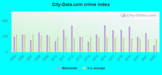
Crime rate in Marionville detailed stats: murders, rapes, robberies, assaults, burglaries, thefts, arson
Full-time law enforcement employees in 2021, including police officers: 4 (4 officers - 2 male; 2 female).
| Officers per 1,000 residents here: | 1.85 |
| Missouri average: | 2.54 |
 Recent articles from our blog. Our writers, many of them Ph.D. graduates or candidates, create easy-to-read articles on a wide variety of topics.

 | Interesting Missouri facts. (1186 replies) |
| Is it true what I've heard (57 replies) |
| Marshfield (4 replies) |
| Your Feedback on these Springfield Suburbs (13 replies) |
| living in billings (5 replies) |
| What towns are 30 Minutes or less of Springfield? (12 replies) |
Latest news from Marionville, MO collected exclusively by city-data.com from local newspapers, TV, and radio stations
Ancestries: American (21.4%), German (15.3%), English (14.4%), Irish (7.4%), Swedish (2.6%), Scotch-Irish (1.1%).
Current Local Time: CST time zone
Incorporated in 1885
Elevation: 1359 feet
Land area: 1.39 square miles.
Population density: 1,505 people per square mile (low).
55 residents are foreign born (1.9% Latin America, 0.4% Europe).
| This city: | 2.1% |
| Missouri: | 4.2% |
Median real estate property taxes paid for housing units with mortgages in 2022: $667 (0.5%)
Median real estate property taxes paid for housing units with no mortgage in 2022: $728 (0.6%)
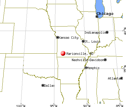
Nearest city with pop. 50,000+: Springfield, MO  (23.6 miles , pop. 151,580).
Nearest city with pop. 200,000+: Tulsa, OK (141.2 miles , pop. 393,049).
Nearest city with pop. 1,000,000+: Dallas, TX (341.0 miles , pop. 1,188,580).
Nearest cities:
), Latitude: 37.00 N, Longitude: 93.64 W
Area code: 417
Single-family new house construction building permits:
- 2009: 1 building, cost: $85,000
- 2008: 2 buildings, average cost: $111,900
- 2007: 2 buildings, average cost: $111,900
- 2006: 3 buildings, average cost: $111,900
- 2005: 3 buildings, average cost: $111,900
- 2004: 4 buildings, average cost: $111,900
- 2003: 4 buildings, average cost: $111,900
- 2002: 3 buildings, average cost: $111,900
- 2001: 3 buildings, average cost: $111,900
- 2000: 3 buildings, average cost: $108,200
- 1999: 4 buildings, average cost: $80,000
- 1998: 14 buildings, average cost: $69,500
- 1997: 13 buildings, average cost: $69,500
| Here: | 2.7% |
| Missouri: | 2.8% |
- Health care (14.8%)
- Educational services (8.1%)
- Construction (7.4%)
- Motor vehicle & parts dealers (5.6%)
- Accommodation & food services (5.3%)
- Truck transportation (4.3%)
- Food & beverage stores (4.2%)
- Construction (14.2%)
- Motor vehicle & parts dealers (8.8%)
- Truck transportation (8.3%)
- Educational services (5.6%)
- Administrative & support & waste management services (4.9%)
- Repair & maintenance (4.9%)
- Printing & related support activities (4.4%)
- Health care (26.5%)
- Educational services (10.8%)
- Accommodation & food services (8.1%)
- Food & beverage stores (6.3%)
- Finance & insurance (4.7%)
- Apparel (4.5%)
- Public administration (4.5%)
- Nursing, psychiatric, and home health aides (7.2%)
- Building and grounds cleaning and maintenance occupations (6.5%)
- Other production occupations, including supervisors (5.8%)
- Driver/sales workers and truck drivers (5.7%)
- Laborers and material movers, hand (5.6%)
- Other office and administrative support workers, including supervisors (3.7%)
- Other sales and related occupations, including supervisors (3.4%)
- Driver/sales workers and truck drivers (11.0%)
- Other production occupations, including supervisors (9.8%)
- Building and grounds cleaning and maintenance occupations (8.3%)
- Laborers and material movers, hand (7.6%)
- Vehicle and mobile equipment mechanics, installers, and repairers (5.6%)
- Retail sales workers, except cashiers (4.4%)
- Carpenters (4.2%)
- Nursing, psychiatric, and home health aides (15.0%)
- Other office and administrative support workers, including supervisors (6.8%)
- Textile, apparel, and furnishings workers (6.0%)
- Health technologists and technicians (5.0%)
- Cashiers (4.5%)
- Building and grounds cleaning and maintenance occupations (4.5%)
- Waiters and waitresses (3.9%)
Average climate in Marionville, Missouri
Based on data reported by over 4,000 weather stations


|
|


(lower is better)
Air Quality Index (AQI) level in 2014 was 69.3. This is about average.
| City: | 69.3 |
| U.S.: | 72.6 |
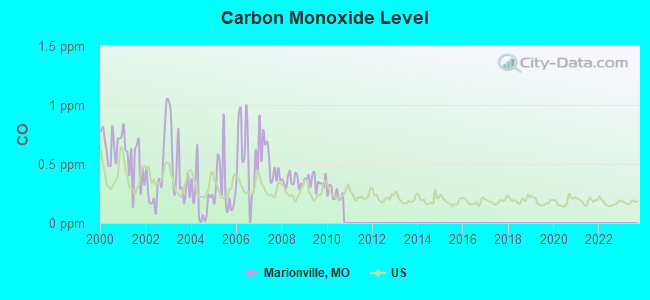
Carbon Monoxide (CO) [ppm] level in 2010 was 0.246. This is about average. Closest monitor was 23.9 miles away from the city center.
| City: | 0.246 |
| U.S.: | 0.251 |
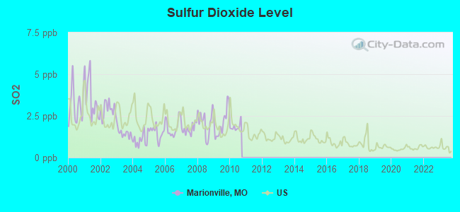
Sulfur Dioxide (SO2) [ppb] level in 2010 was 1.84. This is worse than average. Closest monitor was 19.1 miles away from the city center.
| City: | 1.84 |
| U.S.: | 1.51 |
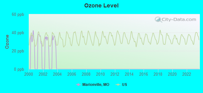
Ozone [ppb] level in 2003 was 32.1. This is about average. Closest monitor was 22.3 miles away from the city center.
| City: | 32.1 |
| U.S.: | 33.3 |
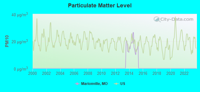
Particulate Matter (PM10) [µg/m3] level in 2014 was 17.3. This is about average. Closest monitor was 10.9 miles away from the city center.
| City: | 17.3 |
| U.S.: | 19.2 |
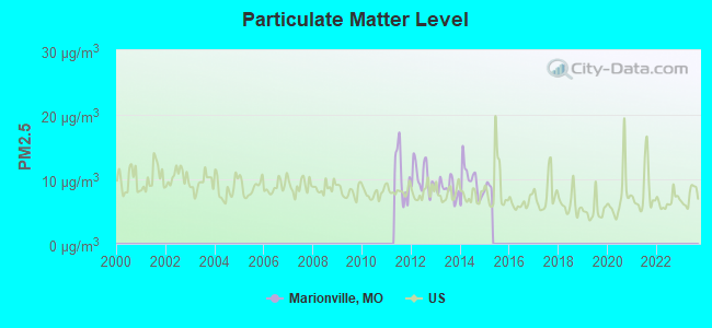
Particulate Matter (PM2.5) [µg/m3] level in 2014 was 9.62. This is about average. Closest monitor was 23.9 miles away from the city center.
| City: | 9.62 |
| U.S.: | 8.11 |
Tornado activity:
Marionville-area historical tornado activity is near Missouri state average. It is 57% greater than the overall U.S. average.
On 11/29/1991, a category F4 (max. wind speeds 207-260 mph) tornado 19.9 miles away from the Marionville city center killed 2 people and injured 64 people and caused between $5,000,000 and $50,000,000 in damages.
On 3/12/2006, a category F3 (max. wind speeds 158-206 mph) tornado 9.1 miles away from the city center killed one person and injured 8 people and caused $56 million in damages.
Earthquake activity:
Marionville-area historical earthquake activity is significantly above Missouri state average. It is 587% greater than the overall U.S. average.On 9/3/2016 at 12:02:44, a magnitude 5.8 (5.8 MW, Depth: 3.5 mi, Class: Moderate, Intensity: VI - VII) earthquake occurred 186.8 miles away from the city center
On 11/6/2011 at 03:53:10, a magnitude 5.7 (5.7 MW, Depth: 3.2 mi) earthquake occurred 201.8 miles away from the city center
On 11/7/2016 at 01:44:24, a magnitude 5.0 (5.0 MW, Depth: 2.8 mi) earthquake occurred 189.3 miles away from Marionville center
On 2/28/2011 at 05:00:50, a magnitude 4.7 (4.7 MW, Depth: 2.0 mi, Class: Light, Intensity: IV - V) earthquake occurred 139.6 miles away from the city center
On 3/25/1976 at 00:41:20, a magnitude 5.0 (4.9 MB, 5.0 LG) earthquake occurred 207.2 miles away from Marionville center
On 5/4/2001 at 06:42:12, a magnitude 4.7 (4.2 MB, 4.7 LG, 4.5 LG) earthquake occurred 148.1 miles away from Marionville center
Magnitude types: regional Lg-wave magnitude (LG), body-wave magnitude (MB), moment magnitude (MW)
Natural disasters:
The number of natural disasters in Lawrence County (17) is near the US average (15).Major Disasters (Presidential) Declared: 11
Emergencies Declared: 4
Causes of natural disasters: Floods: 12, Storms: 11, Tornadoes: 9, Winds: 3, Winter Storms: 3, Heavy Rain: 1, Hurricane: 1, Other: 1 (Note: some incidents may be assigned to more than one category).
Hospitals and medical centers in Marionville:
Other hospitals and medical centers near Marionville:
- MERCY HOSPITAL AURORA Critical Access Hospitals (about 5 miles away; AURORA, MO)
- AURORA NURSING CENTER (Nursing Home, about 5 miles away; AURORA, MO)
- MT VERNON PLACE CARE CENTER, INC (Nursing Home, about 13 miles away; MOUNT VERNON, MO)
- LAWRENCE COUNTY MANOR (Nursing Home, about 13 miles away; MOUNT VERNON, MO)
- MISSOURI REHABILITATION CTR (Hospital, about 13 miles away; MOUNT VERNON, MO)
- SONSHINE MANOR (Nursing Home, about 13 miles away; REPUBLIC, MO)
Colleges/universities with over 2000 students nearest to Marionville:
- Missouri State University-Springfield (about 25 miles; Springfield, MO; Full-time enrollment: 16,660)
- Drury University (about 25 miles; Springfield, MO; FT enrollment: 3,902)
- Ozarks Technical Community College (about 25 miles; Springfield, MO; FT enrollment: 10,356)
- Evangel University (about 26 miles; Springfield, MO; FT enrollment: 2,036)
- Crowder College (about 43 miles; Neosho, MO; FT enrollment: 3,675)
- Southwest Baptist University (about 44 miles; Bolivar, MO; FT enrollment: 2,783)
- Missouri Southern State University (about 46 miles; Joplin, MO; FT enrollment: 4,456)
Public high school in Marionville:
- MARIONVILLE HIGH (Students: 429, Location: 17725 HIGHWAY 14, Grades: 9-12)
Public elementary/middle schools in Marionville:
- MARIONVILLE ELEM. (Students: 345, Location: COLLEGE AND O'DELL, Grades: PK-5)
- MARIONVILLE MIDDLE (Location: COLLEGE AND O'DELL, Grades: 6-8)
User-submitted facts and corrections:
- Marionville Is one of the only two national cities that the albino squirrel lives. added by Bubba
Points of interest:
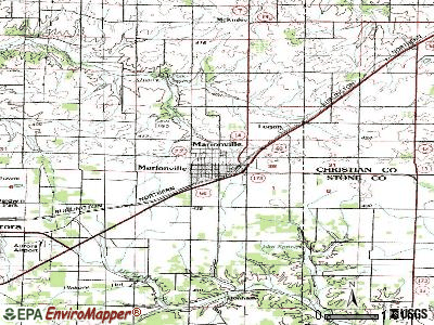
Notable locations in Marionville: Marionville City Fire and Rescue (A), Marionville Rural Fire Department (B). Display/hide their locations on the map
| This city: | 2.4 people |
| Missouri: | 2.5 people |
| This city: | 65.2% |
| Whole state: | 65.3% |
| This city: | 5.8% |
| Whole state: | 6.7% |
Likely homosexual households (counted as self-reported same-sex unmarried-partner households)
- Lesbian couples: 0.2% of all households
- Gay men: 0.0% of all households
106 people in nursing homes in 2000
Banks with branches in Marionville (2011 data):
- Bank of Billings: Marionville Branch at 511 Chestnut Street, branch established on 1963/09/03. Info updated 2010/11/01: Bank assets: $57.4 mil, Deposits: $49.6 mil, headquarters in Billings, MO, positive income, 2 total offices, Holding Company: First Miami Bancshares, Inc.
For population 15 years and over in Marionville:
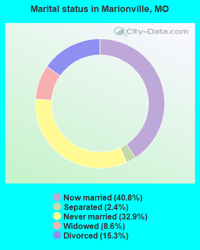
- Never married: 32.9%
- Now married: 40.8%
- Separated: 2.4%
- Widowed: 8.6%
- Divorced: 15.3%
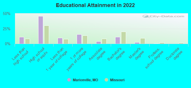
For population 25 years and over in Marionville:
- High school or higher: 87.8%
- Bachelor's degree or higher: 13.6%
- Graduate or professional degree: 2.9%
- Unemployed: 6.6%
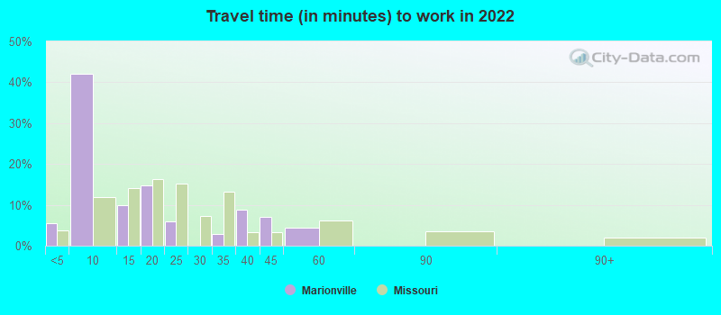
- Mean travel time to work (commute): 19.1 minutes
| Here: | 8.6 |
| Missouri average: | 11.1 |
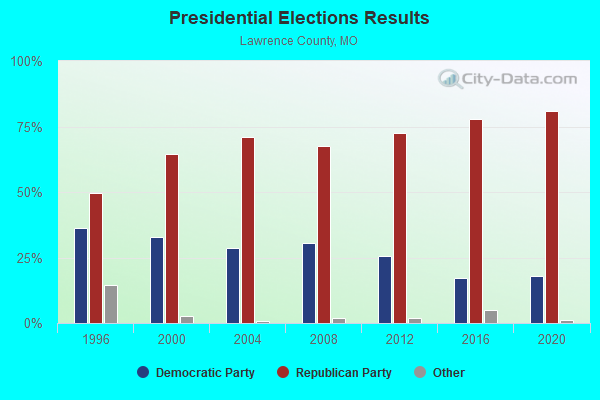
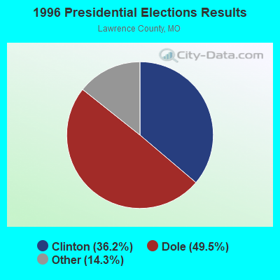
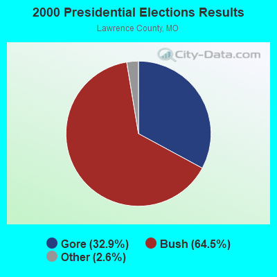
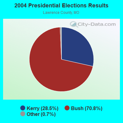

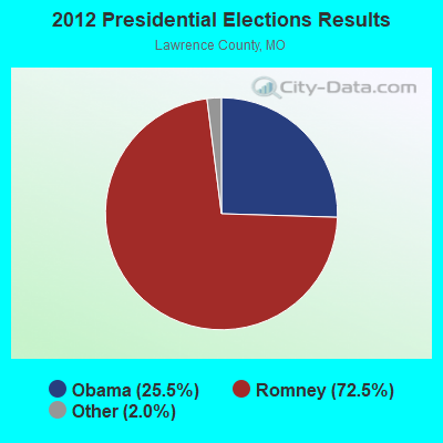
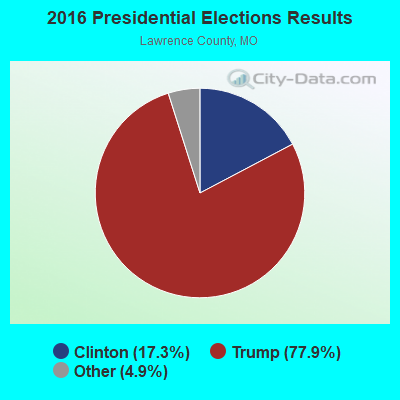
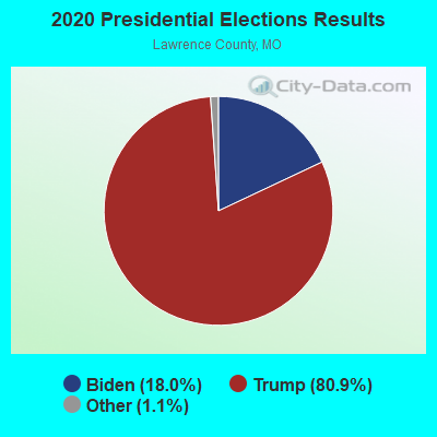
Graphs represent county-level data. Detailed 2008 Election Results
Religion statistics for Marionville, MO (based on Lawrence County data)
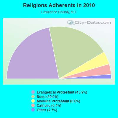

| Religion | Adherents | Congregations |
|---|---|---|
| Evangelical Protestant | 16,970 | 77 |
| Mainline Protestant | 3,087 | 22 |
| Catholic | 2,474 | 4 |
| Other | 1,041 | 5 |
| None | 15,062 | - |
Food Environment Statistics:
| This county: | 1.86 / 10,000 pop. |
| Missouri: | 1.88 / 10,000 pop. |
| Lawrence County: | 0.27 / 10,000 pop. |
| State: | 0.60 / 10,000 pop. |
| Here: | 7.97 / 10,000 pop. |
| Missouri: | 4.34 / 10,000 pop. |
| Here: | 6.91 / 10,000 pop. |
| Missouri: | 7.37 / 10,000 pop. |
| This county: | 8.8% |
| Missouri: | 8.8% |
| Lawrence County: | 29.8% |
| Missouri: | 29.6% |
| This county: | 15.4% |
| Missouri: | 13.5% |
Health and Nutrition:
| Here: | 50.6% |
| State: | 50.9% |
| Marionville: | 48.1% |
| Missouri: | 48.6% |
| Marionville: | 28.6 |
| State: | 28.7 |
| Marionville: | 22.3% |
| Missouri: | 20.6% |
| Marionville: | 10.3% |
| Missouri: | 10.1% |
| Marionville: | 6.9 |
| Missouri: | 6.8 |
| Marionville: | 34.7% |
| Missouri: | 34.3% |
| Here: | 56.3% |
| State: | 57.5% |
| Marionville: | 76.7% |
| Missouri: | 79.3% |
More about Health and Nutrition of Marionville, MO Residents
| Local government employment and payroll (March 2022) | |||||
| Function | Full-time employees | Monthly full-time payroll | Average yearly full-time wage | Part-time employees | Monthly part-time payroll |
|---|---|---|---|---|---|
| Police Protection - Officers | 3 | $12,637 | $50,548 | 0 | $0 |
| Financial Administration | 2 | $7,232 | $43,392 | 0 | $0 |
| Streets and Highways | 2 | $4,913 | $29,478 | 0 | $0 |
| Judicial and Legal | 0 | $0 | 2 | $3,690 | |
| Other and Unallocable | 0 | $0 | 1 | $1,063 | |
| Police - Other | 0 | $0 | 1 | $1,332 | |
| Totals for Government | 7 | $24,783 | $42,485 | 4 | $6,084 |
Marionville government finances - Expenditure in 2017 (per resident):
- Construction - General Public Buildings: $6,000 ($2.88)
- Current Operations - Police Protection: $174,000 ($83.49)
Sewerage: $168,000 ($80.61)
Regular Highways: $113,000 ($54.22)
Central Staff Services: $110,000 ($52.78)
General - Other: $91,000 ($43.67)
Solid Waste Management: $82,000 ($39.35)
Parks and Recreation: $40,000 ($19.19)
Local Fire Protection: $32,000 ($15.36)
Judicial and Legal Services: $28,000 ($13.44)
Health - Other: $12,000 ($5.76)
- General - Interest on Debt: $58,000 ($27.83)
- Intergovernmental to Local - Other - Police Protection: $42,000 ($20.15)
- Other Capital Outlay - Police Protection: $28,000 ($13.44)
Local Fire Protection: $24,000 ($11.52)
Parks and Recreation: $7,000 ($3.36)
- Total Salaries and Wages: $312,000 ($149.71)
Marionville government finances - Revenue in 2017 (per resident):
- Charges - Sewerage: $325,000 ($155.95)
Solid Waste Management: $98,000 ($47.02)
Other: $20,000 ($9.60)
- Local Intergovernmental - General Local Government Support: $1,000 ($0.48)
- Miscellaneous - Fines and Forfeits: $35,000 ($16.79)
Interest Earnings: $6,000 ($2.88)
General Revenue - Other: $4,000 ($1.92)
Rents: $2,000 ($0.96)
- State Intergovernmental - Highways: $59,000 ($28.31)
Sewerage: $21,000 ($10.08)
Other: $7,000 ($3.36)
- Tax - General Sales and Gross Receipts: $440,000 ($211.13)
Public Utilities Sales: $129,000 ($61.90)
Property: $40,000 ($19.19)
Alcoholic Beverage License: $2,000 ($0.96)
Occupation and Business License - Other: $1,000 ($0.48)
Marionville government finances - Debt in 2017 (per resident):
- Long Term Debt - Beginning Outstanding - Unspecified Public Purpose: $1,455,000 ($698.18)
Outstanding Unspecified Public Purpose: $1,290,000 ($619.00)
Retired Unspecified Public Purpose: $165,000 ($79.17)
- Short Term Debt Outstanding - End of Fiscal Year: $46,000 ($22.07)
Beginning: $40,000 ($19.19)
Marionville government finances - Cash and Securities in 2017 (per resident):
- Other Funds - Cash and Securities: $240,000 ($115.16)
Businesses in Marionville, MO
- Dairy Queen: 1
- SONIC Drive-In: 1
- U-Haul: 2
Strongest AM radio stations in Marionville:
- KSWM (940 AM; 1 kW; AURORA, MO; Owner: 940 RADIO, INC.)
- KWTO (560 AM; 5 kW; SPRINGFIELD, MO; Owner: KWTO, INC.)
- KRMO (990 AM; 2 kW; CASSVILLE, MO; Owner: MONETT COMMUNICATIONS, INC.)
- KLFJ (1550 AM; 5 kW; SPRINGFIELD, MO; Owner: 127, INC.)
- KSGF (1260 AM; 5 kW; SPRINGFIELD, MO; Owner: JOURNAL BROADCAST CORPORATION)
- KBTN (1420 AM; 10 kW; NEOSHO, MO; Owner: PETRACOM OF JOPLIN, L.L.C.)
- KKLL (1100 AM; daytime; 5 kW; WEBB CITY, MO; Owner: NEW LIFE EVANGELISTIC CENTER, INC.)
- KKOW (860 AM; 10 kW; PITTSBURG, KS; Owner: AMERICAN MEDIA INVESTMENTS)
- WMBH (1560 AM; 10 kW; JOPLIN, MO)
- KRMG (740 AM; 50 kW; TULSA, OK; Owner: CXR HOLDINGS, INC.)
- KFAQ (1170 AM; 50 kW; TULSA, OK; Owner: JOURNAL BROADCAST CORPORATION)
- WHB (810 AM; 50 kW; KANSAS CITY, MO; Owner: UNION BROADCASTING, INC.)
- KFAY (1030 AM; 10 kW; FARMINGTON, AR; Owner: CUMULUS LICENSING CORP)
Strongest FM radio stations in Marionville:
- KGMY-FM (100.5 FM; AURORA, MO; Owner: CLEAR CHANNEL BROADCASTING LICENSES, INC.)
- KHTO (106.7 FM; MOUNT VERNON, MO; Owner: CITADEL BROADCASTING COMPANY)
- KOMG (92.9 FM; OZARK, MO; Owner: MW SPRINGMO, INC.)
- KTTS-FM (94.7 FM; SPRINGFIELD, MO; Owner: JOURNAL BROADCAST CORPORATION)
- KQMO (97.7 FM; SHELL KNOB, MO; Owner: MAGIC CIRCLE RADIO, INC.)
- KZRQ (104.1 FM; ASH GROVE, MO; Owner: CITADEL BROADCASTING COMPANY)
- KWTO-FM (98.7 FM; SPRINGFIELD, MO; Owner: KWTO, INC.)
- KTXR (101.3 FM; SPRINGFIELD, MO; Owner: STEREO BROADCASTING, INC.)
- KOSP (105.1 FM; WILLARD, MO; Owner: MW SPRINGMO, INC.)
- KXUS (97.3 FM; SPRINGFIELD, MO; Owner: CLEAR CHANNEL BROADCASTING LICENSES, INC.)
- KWFC (89.1 FM; SPRINGFIELD, MO; Owner: BAPTIST BIBLE COLLEGE, INC.)
- KADI (99.5 FM; REPUBLIC, MO; Owner: VISION COMMUNICATIONS, INCORPORATED)
- KSMU (91.1 FM; SPRINGFIELD, MO; Owner: BD OF REGENTS FOR SW MO ST UNIV)
- KKBL (95.9 FM; MONETT, MO; Owner: MONETT COMMUNICATIONS, INC.)
- KSMS-FM (90.5 FM; POINT LOOKOUT, MO; Owner: SOUTHWEST MISSOURI STATE UINIVERSITY)
- KRZK (106.3 FM; BRANSON, MO; Owner: TURTLE BROADCASTING CO. OF BRANSON)
- KSPW (96.5 FM; SPARTA, MO; Owner: JOURNAL BROADCAST CORPORATION)
TV broadcast stations around Marionville:
- KYTV (Channel 3; SPRINGFIELD, MO; Owner: KY3, INC.)
- KOZK (Channel 21; SPRINGFIELD, MO; Owner: BD. OF GOVERNORS OF SW MISSOURI STATE UNIVERSITY)
- K61GJ (Channel 61; AURORA, MO; Owner: NEW LIFE EVANGELISTIC CENTER, INC.)
- KSPR (Channel 33; SPRINGFIELD, MO; Owner: PIEDMONT TELEVISION OF SPRINGFIELD LICENSE LLC)
- KOLR (Channel 10; SPRINGFIELD, MO; Owner: VHR SPRINGFIELD LICENSE, INC.)
- KDEB-TV (Channel 27; SPRINGFIELD, MO; Owner: QUORUM OF MISSOURI LICENSE, LLC)
- K41FQ (Channel 41; SPRINGFIELD, MO; Owner: TRINITY BROADCASTING NETWORK)
- KWBM (Channel 31; HARRISON, AR; Owner: R.S. COMMUNICATIONS LTD. PARTNERSHIP)
- K05KD (Channel 5; CARTHAGE, MO; Owner: WORD OF GOD FELLOWSHIP, INC.)
- K15CZ (Channel 15; SPRINGFIELD, MO; Owner: KY3, INC.)
- K38DD (Channel 38; MONETT, MO; Owner: PEGGY L. DAVIS AND DEBORAH R. KENNY)
- K54FX (Channel 54; SPRINGFIELD, MO; Owner: NEW LIFE EVANGELISTIC CENTER, INC.)
- National Bridge Inventory (NBI) Statistics
- 16Number of bridges
- 69ft / 20.8mTotal length
- $813,000Total costs
- 16,246Total average daily traffic
- 1,403Total average daily truck traffic
- 26,766Total future (year 2040) average daily traffic
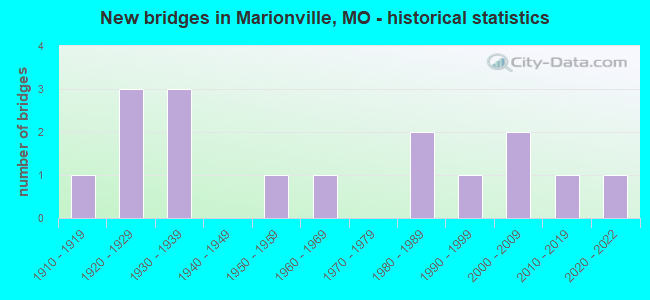
- New bridges - historical statistics
- 11910-1919
- 31920-1929
- 31930-1939
- 11950-1959
- 11960-1969
- 21980-1989
- 11990-1999
- 22000-2009
- 12010-2019
- 12020-2022
FCC Registered Antenna Towers:
42 (See the full list of FCC Registered Antenna Towers in Marionville)FCC Registered Broadcast Land Mobile Towers:
2- 46 E Washington St (Lat: 37.000056 Lon: -93.633528), Call Sign: KNBI427,
Assigned Frequencies: 154.965 MHz, 154.965 MHz, Grant Date: 09/15/2011, Expiration Date: 09/14/2021, Cancellation Date: 11/20/2021, Registrant: City Of Aurora, Marionville, MO 65705, Phone: (417) 463-2466, Email:
- 107 S Central (Lat: 37.004472 Lon: -93.637639), Type: Ltower, Structure height: 15.2 m, Overall height: 18.3 m, Call Sign: WQDV788, Licensee ID: L00059798,
Assigned Frequencies: 154.220 MHz, 154.280 MHz, Grant Date: 09/24/2015, Expiration Date: 11/09/2025, Certifier: Randy Foster, Registrant: City Of Marionville, 107 S. Central, Marionville, MO 65705, Phone: (417) 463-2111, Fax: (417) 258-7525, Email:
FCC Registered Microwave Towers:
5- MARIONVILLE, 3.5 Mi Ne Of (Lat: 37.051972 Lon: -93.614639), Overall height: 63.4 m, Call Sign: WOF96,
Assigned Frequencies: 3710.00 MHz, 3710.00 MHz, 3730.00 MHz, 3730.00 MHz, 3790.00 MHz, 3790.00 MHz, 3810.00 MHz, 3810.00 MHz, 3870.00 MHz, 3870.00 MHz... (+14 more), Grant Date: 02/13/2001, Expiration Date: 02/01/2011, Cancellation Date: 02/05/2002, Registrant: Mci Worldcom Network Services, Inc, 2270 Lakeside Blvd 2865/642, Richardson, TX 75082, Phone: (972) 656-5287, Fax: (972) 656-1622, Email:
- 17 McKinley, 15001 Lawrence 1250 (Mo12471-A) (Lat: 37.052083 Lon: -93.614611), Type: Ltower, Structure height: 60.7 m, Overall height: 62.8 m, Call Sign: WQRS727,
Assigned Frequencies: 11325.0 MHz, 11325.0 MHz, 11565.0 MHz, Grant Date: 05/01/2023, Expiration Date: 07/19/2033, Certifier: Ryan Shorney, Registrant: Intelpath, Hinsdale, IL 60522, Phone: (312) 841-9188, Email:
- ST15RW121, 15001 Lawrence 1250 (Mo12471-A) (Lat: 37.052194 Lon: -93.614611), Type: Gtower, Structure height: 60.7 m, Overall height: 62.8 m, Call Sign: WQSG537,
Assigned Frequencies: 11425.0 MHz, 11345.0 MHz, 11345.0 MHz, 11425.0 MHz, 11425.0 MHz, 11345.0 MHz, 11425.0 MHz, 11345.0 MHz, 11425.0 MHz, 11345.0 MHz, 11345.0 MHz, 11425.0 MHz, Grant Date: 09/17/2013, Expiration Date: 09/17/2023, Cancellation Date: 05/08/2023, Certifier: David Werblow, Registrant: T-Mobile Usa, Inc., 12920 Se 38th Street, Bellevue, WA 98006, Phone: (425) 383-8401, Email:
- US 60HWY&FR, 22978 Lawrence 2200 (Lat: 36.981972 Lon: -93.651500), Type: Ltower, Structure height: 70.1 m, Overall height: 76.2 m, Call Sign: WQUL589,
Assigned Frequencies: 6197.24 MHz, 6197.24 MHz, 6226.89 MHz, 6256.54 MHz, 6256.54 MHz, 6286.19 MHz, Grant Date: 08/11/2014, Expiration Date: 08/11/2024, Certifier: John Monday, Registrant: At&t Services, Inc., 208 S Akard St, 20f, Dallas, TX 75202, Phone: (855) 699-7073, Email:
- LWRNMOAB, 17807 Larence 1247 (Lat: 37.011556 Lon: -93.616167), Type: Gtower, Structure height: 105.2 m, Overall height: 106.4 m, Call Sign: WRZH610, Licensee ID: L02347278,
Assigned Frequencies: 11485.0 MHz, 11485.0 MHz, 11485.0 MHz, 11485.0 MHz, 11485.0 MHz, 11485.0 MHz, 11485.0 MHz, 11485.0 MHz, 11485.0 MHz, 11485.0 MHz, Grant Date: 11/02/2023, Expiration Date: 11/02/2033, Certifier: Dave Mills, Registrant: Wisper Isp, LLC, 9711 Fuesser Road, Mascoutah, IL 62258, Phone: (618) 206-4190, Email:
FCC Registered Amateur Radio Licenses:
27 (See the full list of FCC Registered Amateur Radio Licenses in Marionville)FAA Registered Aircraft:
2- Aircraft: PIPER PA-32-260 (Category: Land, Seats: 6, Weight: Up to 12,499 Pounds, Speed: 126 mph), Engine: LYCOMING 0-540 SERIES (250 HP) (Reciprocating)
N-Number: 4835S, N4835S, N-4835S, Serial Number: 32-1264, Year manufactured: 1970, Airworthiness Date: 04/30/1970, Certificate Issue Date: 12/27/2019
Registrant (Individual): Jamie Holder, 20749 Lawrence 1240, Marionville, MO 65705 - Aircraft: PIPER PA-28-235 (Category: Land, Seats: 4, Weight: Up to 12,499 Pounds, Speed: 107 mph), Engine: LYCOMING 0-540 SERIES (250 HP) (Reciprocating)
N-Number: 9345W, N9345W, N-9345W, Serial Number: 28-11032, Year manufactured: 1968, Airworthiness Date: 02/27/1968, Certificate Issue Date: 01/07/2016
Registrant (Individual): Basil F Minor, 950 S Western, Marionville, MO 65705
Deregistered: Cancel Date: 05/06/2019
2002 - 2018 National Fire Incident Reporting System (NFIRS) incidents
- Fire incident types reported to NFIRS in Marionville, MO
- 11646.8%Outside Fires
- 6727.0%Structure Fires
- 4618.5%Other
- 197.7%Mobile Property/Vehicle Fires
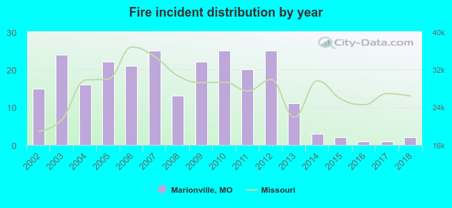 According to the data from the years 2002 - 2018 the average number of fire incidents per year is 15. The highest number of reported fire incidents - 25 took place in 2007, and the least - 1 in 2016. The data has a declining trend.
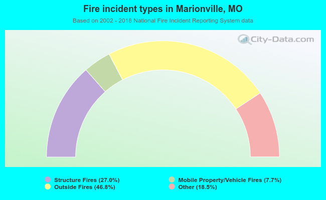 When looking into fire subcategories, the most incidents belonged to: Outside Fires (46.8%), and Structure Fires (27.0%).
| Most common first names in Marionville, MO among deceased individuals | ||
| Name | Count | Lived (average) |
|---|---|---|
| John | 36 | 78.4 years |
| William | 33 | 78.2 years |
| Mary | 28 | 85.4 years |
| James | 20 | 71.5 years |
| Ruth | 20 | 84.8 years |
| Helen | 18 | 84.1 years |
| Robert | 16 | 75.2 years |
| George | 15 | 83.1 years |
| Charles | 15 | 76.1 years |
| Alice | 13 | 84.8 years |
| Most common last names in Marionville, MO among deceased individuals | ||
| Last name | Count | Lived (average) |
|---|---|---|
| Johnson | 22 | 82.2 years |
| Jones | 17 | 76.2 years |
| Smith | 15 | 80.1 years |
| Brown | 15 | 69.6 years |
| Morris | 12 | 73.0 years |
| Miller | 11 | 78.0 years |
| Cook | 9 | 75.9 years |
| Moore | 9 | 82.9 years |
| Gold | 8 | 77.7 years |
| Forrester | 8 | 81.9 years |
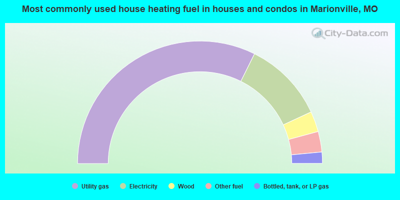
- 64.7%Utility gas
- 21.5%Electricity
- 5.4%Wood
- 5.4%Other fuel
- 3.0%Bottled, tank, or LP gas
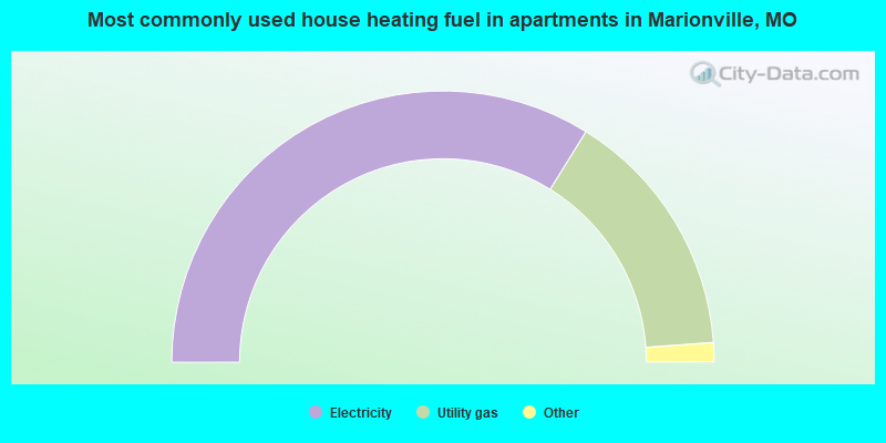
- 67.7%Electricity
- 30.0%Utility gas
- 1.3%Wood
- 1.0%Bottled, tank, or LP gas
Marionville compared to Missouri state average:
- Median house value below state average.
- Unemployed percentage below state average.
- Black race population percentage significantly below state average.
- Hispanic race population percentage above state average.
- Median age above state average.
- Foreign-born population percentage below state average.
- Length of stay since moving in above state average.
- Institutionalized population percentage above state average.
- Number of college students below state average.
- Percentage of population with a bachelor's degree or higher below state average.

|
Total of 6 patent applications in 2008-2024.