McCullough-Huxford, Alabama
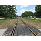
McCullough-Huxford: Huxford Train Tracks -Center of Town
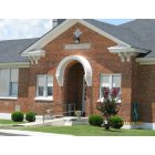
McCullough-Huxford: Huxford High School
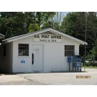
McCullough-Huxford: Huxford Post Office
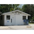
McCullough-Huxford: Huxford Post Office
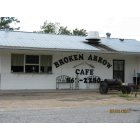
McCullough-Huxford: Middle of town
- add
your
Submit your own pictures of this place and show them to the world
- OSM Map
- Google Map
- MSN Map
| Males: 3,761 | |
| Females: 1,344 |
| Median resident age: | 33.8 years |
| Alabama median age: | 35.8 years |
Zip code: 36502
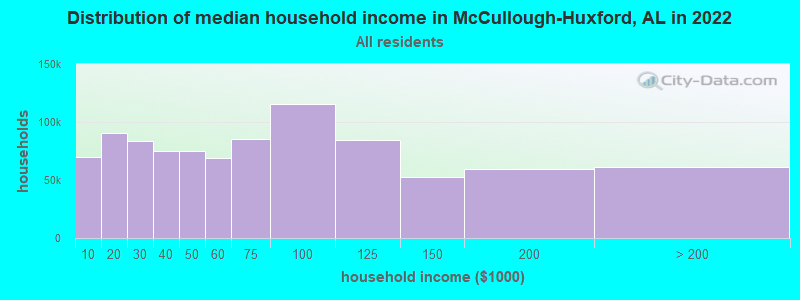
| McCullough-Huxford: | $45,462 |
| AL: | $59,674 |
Estimated per capita income in 2022: $11,864 (it was $7,749 in 2000)
McCullough-Huxford CCD income, earnings, and wages data
Estimated median house or condo value in 2022: $115,899 (it was $48,100 in 2000)
| McCullough-Huxford: | $115,899 |
| AL: | $200,900 |
McCullough-Huxford, AL residents, houses, and apartments details
Detailed information about poverty and poor residents in McCullough-Huxford, AL


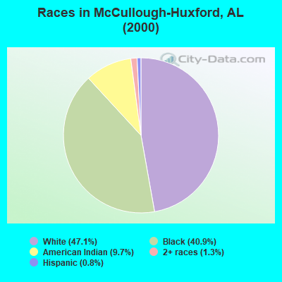
- 2,45247.1%White alone
- 2,13340.9%Black alone
- 5049.7%American Indian alone
- 701.3%Two or more races
- 430.8%Hispanic
- 50.10%Other race alone
- 40.08%Asian alone
 Recent articles from our blog. Our writers, many of them Ph.D. graduates or candidates, create easy-to-read articles on a wide variety of topics.
Current Local Time: CST time zone
Land area: 175.5 square miles.
Population density: 29 people per square mile (very low).
| McCullough-Huxford CCD: | 0.4% ($199) |
| Alabama: | 0.4% ($289) |
Nearest city with pop. 50,000+: Mobile, AL  (50.5 miles , pop. 198,915).
Nearest city with pop. 200,000+: Montgomery, AL (108.2 miles , pop. 201,568).
Nearest city with pop. 1,000,000+: Houston, TX (481.4 miles , pop. 1,953,631).
Nearest cities:
), ), )Latitude: 31.17 N, Longitude: 87.47 W
Area code commonly used in this area: 251
| Here: | 3.4% |
| Alabama: | 2.6% |
- Public administration (10.6%)
- Construction (10.0%)
- Educational services (6.2%)
- Accommodation & food services (5.9%)
- Health care (5.3%)
- Wood products (4.9%)
- Metal & metal products (4.6%)
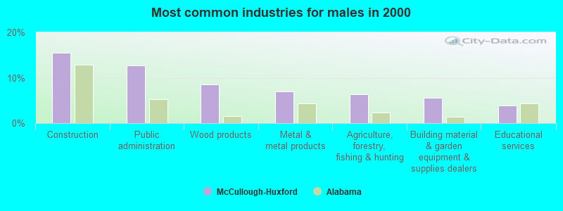
- Construction (15.5%)
- Public administration (12.7%)
- Wood products (8.5%)
- Metal & metal products (6.9%)
- Agriculture, forestry, fishing & hunting (6.3%)
- Building material & garden equipment & supplies dealers (5.6%)
- Educational services (3.9%)
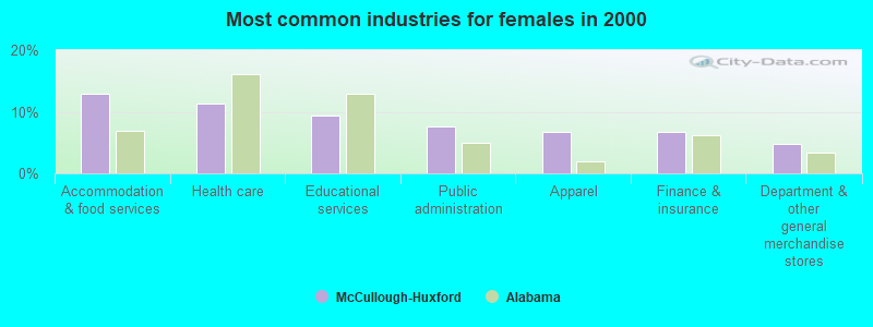
- Accommodation & food services (12.9%)
- Health care (11.4%)
- Educational services (9.4%)
- Public administration (7.6%)
- Apparel (6.8%)
- Finance & insurance (6.8%)
- Department & other general merchandise stores (4.8%)
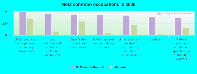
- Other production occupations, including supervisors (4.9%)
- Law enforcement workers, including supervisors (4.5%)
- Driver/sales workers and truck drivers (4.4%)
- Textile, apparel, and furnishings workers (4.3%)
- Other sales and related occupations, including supervisors (4.2%)
- Cashiers (3.9%)
- Material recording, scheduling, dispatching, and distributing workers (3.6%)
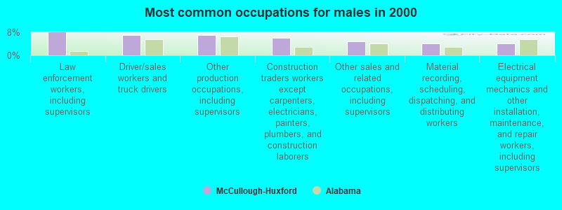
- Law enforcement workers, including supervisors (7.9%)
- Driver/sales workers and truck drivers (6.9%)
- Other production occupations, including supervisors (6.9%)
- Construction traders workers except carpenters, electricians, painters, plumbers, and construction laborers (6.0%)
- Other sales and related occupations, including supervisors (4.8%)
- Material recording, scheduling, dispatching, and distributing workers (4.2%)
- Electrical equipment mechanics and other installation, maintenance, and repair workers, including supervisors (4.2%)
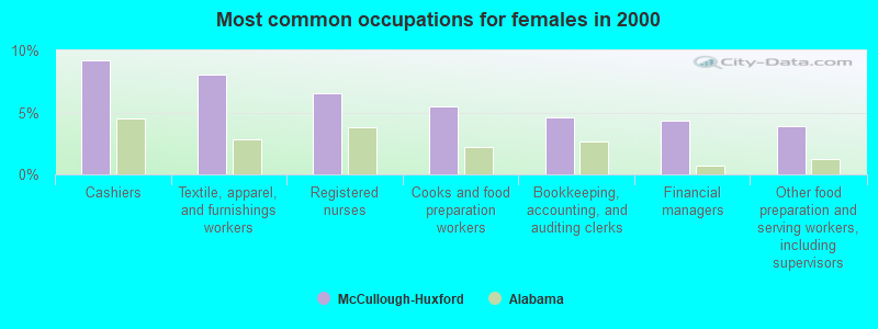
- Cashiers (9.2%)
- Textile, apparel, and furnishings workers (8.1%)
- Registered nurses (6.6%)
- Cooks and food preparation workers (5.5%)
- Bookkeeping, accounting, and auditing clerks (4.6%)
- Financial managers (4.4%)
- Other food preparation and serving workers, including supervisors (3.9%)
Average climate in McCullough-Huxford, Alabama
Based on data reported by over 4,000 weather stations


Tornado activity:
McCullough-Huxford-area historical tornado activity is below Alabama state average. It is 29% greater than the overall U.S. average.
On 4/23/1971, a category F4 (max. wind speeds 207-260 mph) tornado 25.0 miles away from the McCullough-Huxford place center caused between $5000 and $50,000 in damages.
On 12/20/1971, a category F3 (max. wind speeds 158-206 mph) tornado 9.4 miles away from the place center injured one person and caused between $50,000 and $500,000 in damages.
Earthquake activity:
McCullough-Huxford-area historical earthquake activity is significantly above Alabama state average. It is 54% greater than the overall U.S. average.On 10/24/1997 at 08:35:17, a magnitude 4.9 (4.8 MB, 4.2 MS, 4.9 LG, Depth: 6.2 mi, Class: Light, Intensity: IV - V) earthquake occurred 12.3 miles away from McCullough-Huxford center
On 1/18/1999 at 07:00:53, a magnitude 4.8 (4.8 MB, 4.0 LG, Depth: 0.6 mi) earthquake occurred 155.1 miles away from McCullough-Huxford center
On 11/7/2004 at 11:20:21, a magnitude 4.3 (4.3 MW, Depth: 3.1 mi) earthquake occurred 105.8 miles away from the city center
On 9/3/2020 at 15:07:53, a magnitude 3.8 (3.8 MW, Depth: 2.5 mi, Class: Light, Intensity: II - III) earthquake occurred 19.6 miles away from the city center
On 10/26/1997 at 23:27:12, a magnitude 3.7 (3.7 LG, Depth: 6.2 mi) earthquake occurred 11.3 miles away from McCullough-Huxford center
On 6/24/1975 at 11:11:36, a magnitude 4.5 (4.5 MB) earthquake occurred 177.6 miles away from the city center
Magnitude types: regional Lg-wave magnitude (LG), body-wave magnitude (MB), surface-wave magnitude (MS), moment magnitude (MW)
Natural disasters:
The number of natural disasters in Escambia County (21) is greater than the US average (15).Major Disasters (Presidential) Declared: 13
Emergencies Declared: 6
Causes of natural disasters: Hurricanes: 9, Floods: 8, Storms: 8, Tornadoes: 6, Winds: 3, Drought: 1, Snowfall: 1, Winter Storm: 1, Other: 1 (Note: some incidents may be assigned to more than one category).
Hospitals and medical centers near McCullough-Huxford:
- ATMORE COMMUNITY HOSPITAL Acute Care Hospitals (about 11 miles away; ATMORE, AL)
- ATMORE DIALYSIS CENTER (Dialysis Facility, about 11 miles away; ATMORE, AL)
- ATMORE NURSING CENTER (Nursing Home, about 11 miles away; ATMORE, AL)
- ATMORE COMMUNITY HOME CARE, LLC (Home Health Center, about 12 miles away; ATMORE, AL)
Colleges/universities with over 2000 students nearest to McCullough-Huxford:
- James H Faulkner State Community College (about 29 miles; Bay Minette, AL; Full-time enrollment: 3,703)
- The University of West Florida (about 46 miles; Pensacola, FL; FT enrollment: 10,240)
- Bishop State Community College (about 48 miles; Mobile, AL; FT enrollment: 2,822)
- Pensacola State College (about 51 miles; Pensacola, FL; FT enrollment: 8,740)
- University of South Alabama (about 54 miles; Mobile, AL; FT enrollment: 13,228)
- Columbia Southern University (about 60 miles; Orange Beach, AL; FT enrollment: 14,996)
- Northwest Florida State College (about 74 miles; Niceville, FL; FT enrollment: 5,052)
Points of interest:
Notable locations in McCullough-Huxford: Atmore Inert Landfill (A), Fountain Correctional Facility Sewage Lagoon (B), Rivercane Number 3 Industrial Park (C), Huxford Volunteer Fire Department (D), Atmore State Prison Farm (E), Poarch Volunteer Fire Department (F), McCullough Volunteer Fire Department (G), Poarch Creek Museum (H), Barnett Crossroads Volunteer Fire Department (I). Display/hide their locations on the map
Churches in McCullough-Huxford include: New Home Church (A), Pleasant Grove Baptist Church (B), Huxford Baptist Church (C), Friendly Church (D), Sardis Church (E), Travelers Rest Church (F), Canaan Church (G), Huxford Church (H), Poarch Mission Church (I). Display/hide their locations on the map
Cemeteries: Driskell Cemetery (1), Lindsey Cemetery (2), Hawkins Cemetery (3), Huxford Church Cemetery (4), Jack Springs Cemetery (5), Judson Cemetery (6), Mothershed Cemetery (7). Display/hide their locations on the map
Lakes and reservoirs: Little River Lake (A), Okwakee Lake (B), Leo Williams Dam (C), Lake George White (D). Display/hide their locations on the map
Streams, rivers, and creeks: Robinson Creek (A), Rabbit Branch (B), Pieburn Branch (C), Long Hollow Creek (D), Jim Lomax Branch (E), Jim Boone Branch (F), Clare Creek (G), Chitterling Creek (H), Broken Leg Creek (I). Display/hide their locations on the map
Park in McCullough-Huxford: Edward Hauss State Forest Nursery (1). Display/hide its location on the map
| This place: | 2.6 people |
| Alabama: | 2.5 people |
| This place: | 69.9% |
| Whole state: | 67.8% |
| This place: | 6.4% |
| Whole state: | 4.7% |
Likely homosexual households (counted as self-reported same-sex unmarried-partner households)
- Lesbian couples: 0.5% of all households
- Gay men: 0.2% of all households
| This place: | 41.6% |
| Whole state: | 16.1% |
| This place: | 31.5% |
| Whole state: | 7.3% |
247 people in correctional residential facilities in 2010
1,434 people in state prisons in 2000
1,096 people in other noninstitutional group quarters in 2000
For population 15 years and over in McCullough-Huxford:
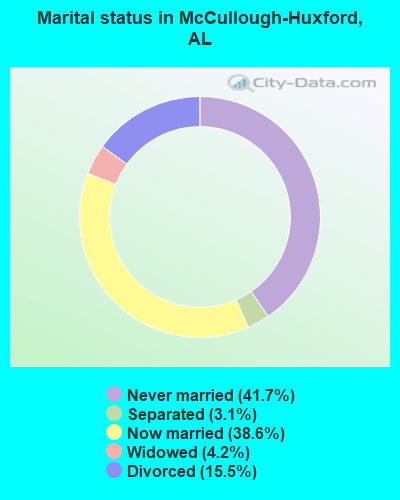
- Never married: 41.7%
- Now married: 38.6%
- Separated: 3.1%
- Widowed: 4.2%
- Divorced: 15.5%
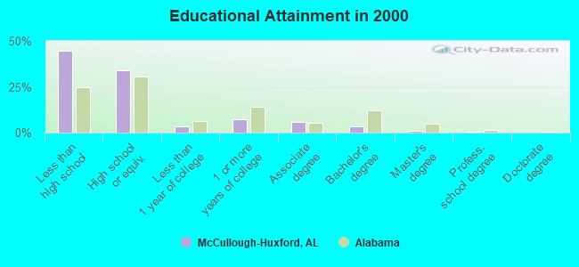
For population 25 years and over in McCullough-Huxford:
- High school or higher: 55.2%
- Bachelor's degree or higher: 4.7%
- Graduate or professional degree: 1.1%
- Unemployed: 6.4%
- Mean travel time to work (commute): 32.8 minutes
| Here: | 11.0 |
| Alabama average: | 13.2 |
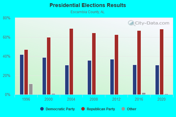
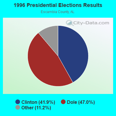
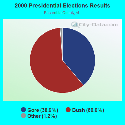
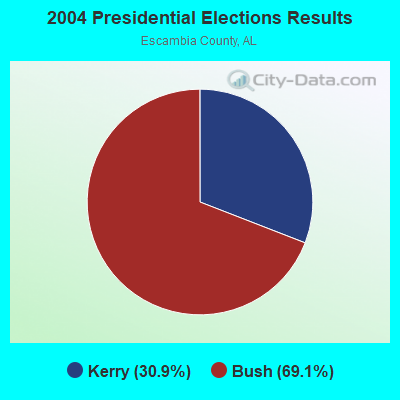
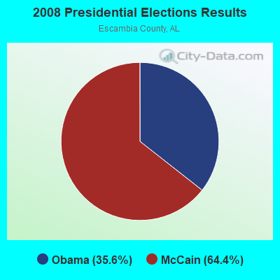
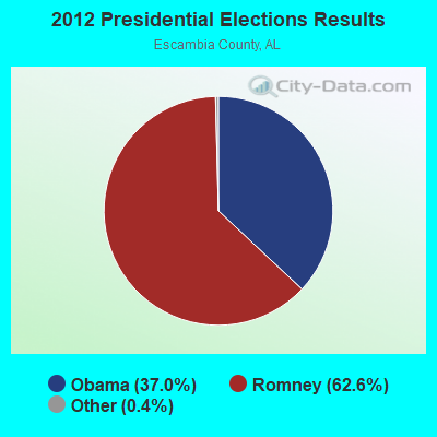
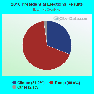
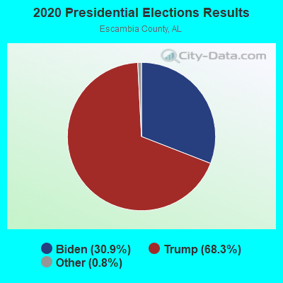
Graphs represent county-level data. Detailed 2008 Election Results
Religion statistics for McCullough-Huxford, AL (based on Escambia County data)
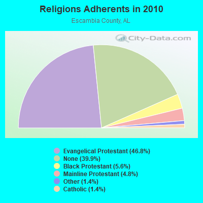
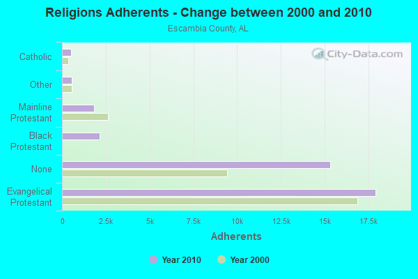
| Religion | Adherents | Congregations |
|---|---|---|
| Evangelical Protestant | 17,917 | 88 |
| Black Protestant | 2,164 | 10 |
| Mainline Protestant | 1,849 | 18 |
| Other | 554 | 6 |
| Catholic | 530 | 2 |
| None | 15,305 | - |
Food Environment Statistics:
| This county: | 2.40 / 10,000 pop. |
| State: | 1.89 / 10,000 pop. |
| Escambia County: | 0.27 / 10,000 pop. |
| State: | 0.65 / 10,000 pop. |
| Escambia County: | 7.72 / 10,000 pop. |
| Alabama: | 6.32 / 10,000 pop. |
| This county: | 5.33 / 10,000 pop. |
| Alabama: | 5.75 / 10,000 pop. |
| This county: | 11.4% |
| Alabama: | 11.8% |
| Escambia County: | 35.2% |
| Alabama: | 31.7% |
| Escambia County: | 12.1% |
| Alabama: | 13.5% |
Strongest AM radio stations in McCullough-Huxford:
- WASG (550 AM; 25 kW; ATMORE, AL; Owner: 550 AM, INC)
- WBCA (1110 AM; daytime; 10 kW; BAY MINETTE, AL; Owner: SOUTHERN MEDIA COMMUNICATIONS, INC)
- WYNI (930 AM; 5 kW; MONROEVILLE, AL; Owner: MCKISSICK ENTERPRISES)
- WEBY (1330 AM; 25 kW; MILTON, FL; Owner: SPINNAKER LICENSE CORPORATION)
- WDLT (660 AM; 10 kW; FAIRHOPE, AL; Owner: CUMULUS LICENSING CORP.)
- WNTM (710 AM; 10 kW; MOBILE, AL; Owner: CLEAR CHANNEL BROADCASTING LICENSES, INC.)
- WBHY (840 AM; daytime; 10 kW; MOBILE, AL; Owner: GOFORTH MEDIA, INC.)
- WNVY (1090 AM; daytime; 10 kW; CANTONMENT, FL; Owner: 1090-AM INC.)
- WSJC (810 AM; 50 kW; MAGEE, MS; Owner: FAMILY TALK RADIO)
- WJOX (690 AM; 50 kW; BIRMINGHAM, AL; Owner: CITADEL BROADCASTING COMPANY)
- WLPR (960 AM; 5 kW; PRICHARD, AL; Owner: GOFORTH MEDIA, INC.)
- WDJC (850 AM; 50 kW; BIRMINGHAM, AL; Owner: KIMTRON, INC.)
- WKSJ (1270 AM; 5 kW; PRICHARD, AL; Owner: CLEAR CHANNEL BROADCASTING LICENSES, INC.)
Strongest FM radio stations in McCullough-Huxford:
- WYDH (105.9 FM; ATMORE, AL; Owner: SOUTHERN MEDIA COMMUNICATIONS, INC.)
- WYCL (107.3 FM; PENSACOLA, FL; Owner: CONCORD MEDIA GROUP, INC.)
- WMXC (99.9 FM; MOBILE, AL; Owner: CLEAR CHANNEL BROADCASTING LICENSES, INC.)
- WRKH (96.1 FM; MOBILE, AL; Owner: CLEAR CHANNEL BROADCASTING LICENSES, INC.)
- WKSJ-FM (94.9 FM; MOBILE, AL; Owner: CLEAR CHANNEL BROADCASTING LICENSES, INC.)
- WABB-FM (97.5 FM; MOBILE, AL; Owner: WABB-FM, INC.)
- WJLQ (100.7 FM; PENSACOLA, FL; Owner: CUMULUS LICENSING CORP.)
- WBLX-FM (92.9 FM; MOBILE, AL; Owner: CUMULUS LICENSING CORP.)
- WYOK (104.1 FM; ATMORE, AL; Owner: CUMULUS LICENSING CORP.)
- WMEZ (94.1 FM; PENSACOLA, FL; Owner: 6 JOHNSON ROAD LICENSES, INC.)
- WXBM-FM (102.7 FM; MILTON, FL; Owner: 6 JOHNSON ROAD LICENSES, INC.)
- WPCS (89.5 FM; PENSACOLA, FL; Owner: PENSACOLA CHRISTIAN COLLEGE, INC)
- WTKX-FM (101.5 FM; PENSACOLA, FL; Owner: CLEAR CHANNEL BROADCASTING LICENSES, INC.)
- WPFL (105.1 FM; CENTURY, FL; Owner: TRI-COUNTY BROADCASTING, INC.)
- WHNB (94.5 FM; JACKSON, AL; Owner: CAPITAL ASSETS, INC.)
- WPGG (93.3 FM; EVERGREEN, AL; Owner: GULF COAST BROADCASTING COMPANY, INC)
- WHIL-FM (91.3 FM; MOBILE, AL; Owner: SPRING HILL COLLEGE)
- WFNU (101.1 FM; REPTON, AL; Owner: BRANTLEY BROADCAST ASSOCIATES)
- WGCX (95.7 FM; NAVARRE, FL; Owner: 550 AM, INC)
- WELJ (90.9 FM; BREWTON, AL; Owner: GATEWAY PUBLIC RADIO)
TV broadcast stations around McCullough-Huxford:
- WEAR-TV (Channel 3; PENSACOLA, FL; Owner: WEAR LICENSEE, LLC)
- WKRG-TV (Channel 5; MOBILE, AL; Owner: MEDIA GENERAL BROADCASTING OF SOUTH CAROLINA HOLDINGS, INC.)
- WMPV-TV (Channel 21; MOBILE, AL; Owner: TRINITY BROADCASTING NETWORK)
- WPMI (Channel 15; MOBILE, AL; Owner: CLEAR CHANNEL BROADCASTING LICENSES, INC.)
- WJTC (Channel 44; PENSACOLA, FL; Owner: CLEAR CHANNEL BROADCASTING LICENSES, INC.)
- WHBR (Channel 33; PENSACOLA, FL; Owner: CHRISTIAN TELEVISION OF PENSACOLA/MOBILE, INC.)
- WSRE (Channel 23; PENSACOLA, FL; Owner: DST .BD. OF TRUSTEES PENSACOLA JR. COLLEGE)
- WRBM-LP (Channel 60; PRICHARD, AL; Owner: UPPER GULF COAST, L.L.C.)
- WALA-TV (Channel 10; MOBILE, AL; Owner: EMMIS TELEVISION LICENSE CORPORATION)
- WBPG (Channel 55; GULF SHORES, AL; Owner: EMMIS TELEVISION LICENSE CORPORATION)
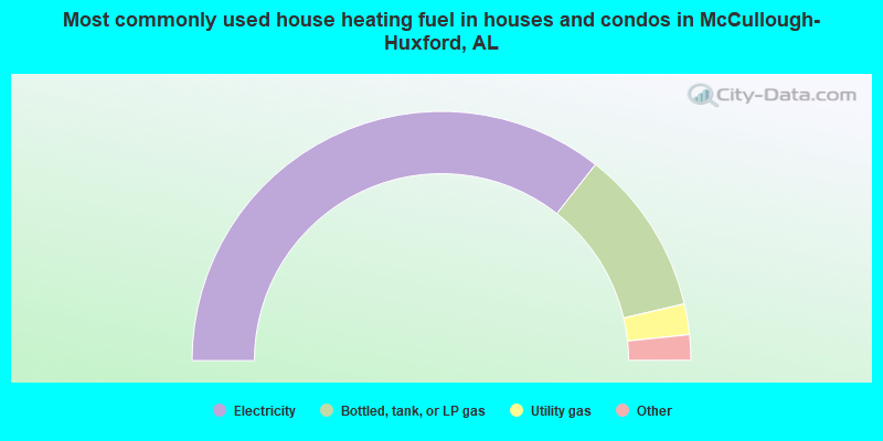
- 71.2%Electricity
- 21.5%Bottled, tank, or LP gas
- 4.0%Utility gas
- 2.4%Wood
- 0.9%No fuel used
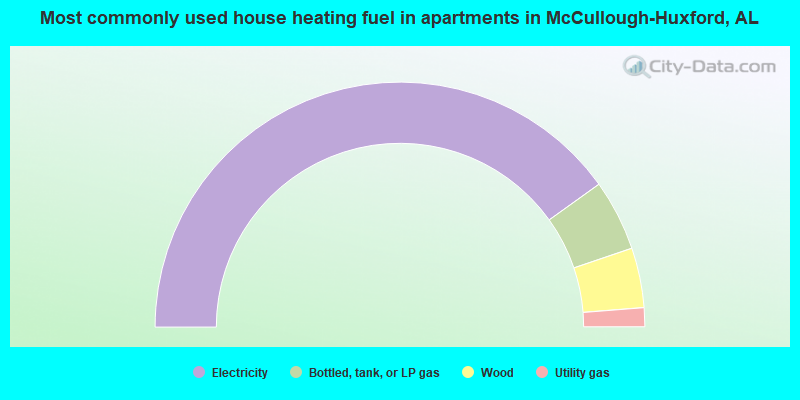
- 80.2%Electricity
- 9.4%Bottled, tank, or LP gas
- 7.9%Wood
- 2.5%Utility gas
McCullough-Huxford compared to Alabama state average:
- Median house value below state average.
- Unemployed percentage below state average.
- Hispanic race population percentage significantly below state average.
- Median age significantly below state average.
- Foreign-born population percentage significantly below state average.
- Length of stay since moving in significantly above state average.
- Number of rooms per house significantly below state average.
- House age significantly below state average.
- Institutionalized population percentage significantly above state average.
- Number of college students below state average.
- Percentage of population with a bachelor's degree or higher significantly below state average.
McCullough-Huxford on our top lists:
- #1 on the list of "Top 101 cities with largest percentage of females in occupations: financial managers (population 5,000+)"
- #2 on the list of "Top 101 cities with the largest percentage of people in other noninstitutional group quarters (population 1,000+)"
- #3 on the list of "Top 101 cities with largest percentage of males in industries: vending machine operators (population 5,000+)"
- #3 on the list of "Top 101 cities with largest percentage of males in industries: building material and garden equipment and supplies dealers (population 5,000+)"
- #6 on the list of "Top 101 cities with largest percentage of males in occupations: other transportation workers (population 5,000+)"
- #7 on the list of "Top 101 cities with largest percentage of females in industries: apparel (population 5,000+)"
- #10 on the list of "Top 101 cities with largest percentage of females in occupations: other food preparation and serving workers including supervisors (population 5,000+)"
- #11 on the list of "Top 101 cities with largest percentage of males in occupations: woodworkers (population 5,000+)"
- #12 on the list of "Top 101 cities with largest percentage of females in occupations: cashiers (population 5,000+)"
- #14 on the list of "Top 100 cities with the largest percentage of males (pop. 5,000+)"
- #15 on the list of "Top 101 cities with largest percentage of females in occupations: drafters, engineering, and mapping technicians (population 5,000+)"
- #16 on the list of "Top 101 cities with largest percentage of males in industries: farm supplies merchant wholesalers (population 5,000+)"
- #21 on the list of "Top 101 cities with largest percentage of females in industries: truck transportation (population 5,000+)"
- #22 on the list of "Top 101 cities with largest percentage of females in industries: broadcasting and telecommunications (population 5,000+)"
- #22 on the list of "Top 101 cities with largest percentage of males in industries: water transportation (population 5,000+)"
- #23 on the list of "Top 101 cities with largest percentage of males in industries: furniture and related product manufacturing (population 5,000+)"
- #23 on the list of "Top 101 cities with largest percentage of males in industries: wood products (population 5,000+)"
- #36 on the list of "Top 101 cities with largest percentage of males in industries: hardware, plumbing and heating equipment, and supplies merchant wholesalers (population 5,000+)"
- #44 on the list of "Top 101 cities with largest percentage of males in industries: machinery, equipment, and supplies merchant wholesalers (population 5,000+)"
- #45 on the list of "Top 101 cities with largest percentage of females in industries: furniture and home furnishings, and household appliance stores (population 5,000+)"