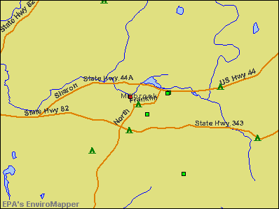
Millbrook, New York

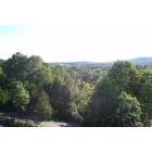
Millbrook: Millbrook Countryside in October
Millbrook: Millbrook Diner
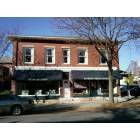
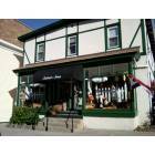
Millbrook: Reardon Briggs Hardware
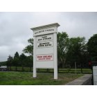
Millbrook: Tuxis Self Storage
Millbrook: Tuxis Self Storage

Millbrook: Bobcat at the Trevor Zoo in Millbrook, NY
Millbrook: Trevor Zoo in Millbrook, NY
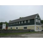
Millbrook: View from the Rooftop; Millbrook, New York
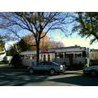
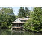
Millbrook: Millbrook 1
- add
your


Submit your own pictures of this village and show them to the world
(10.6% for White Non-Hispanic residents, 32.7% for Black residents, 40.0% for Hispanic or Latino residents, 51.5% for two or more races residents)
Detailed information about poverty and poor residents in Millbrook, NY
 Recent articles from our blog. Our writers, many of them Ph.D. graduates or candidates, create easy-to-read articles on a wide variety of topics.

Millbrook tourist attractions:
- Innisfree Garden - Millbrook, NY - Garden and Lake
- Cary Institute of Ecosystem Studies - Millbrook, New York - An Education on Ecosystems
- Orvis Sandanona Shooting Grounds - Millbrook, NY - Sporting Clays, Fly Fishing, and More
- Trevor Zoo - Millbrook, New York - small private zoo with 180 animals on 6 acres
| Here: | 3.6% |
| New York: | 4.4% |
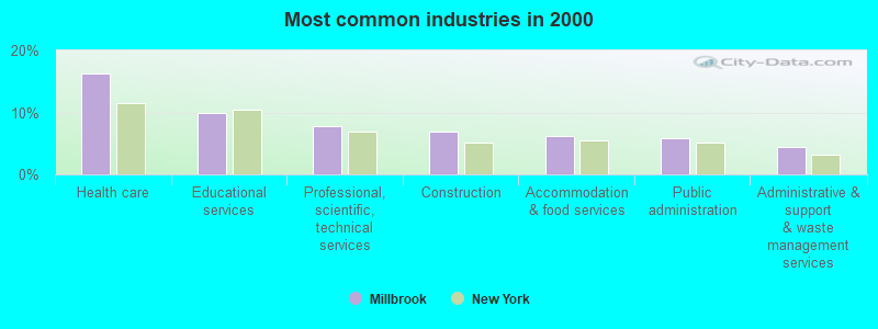
- Health care (16.4%)
- Educational services (9.9%)
- Professional, scientific, technical services (7.8%)
- Construction (6.9%)
- Accommodation & food services (6.2%)
- Public administration (5.8%)
- Administrative & support & waste management services (4.4%)
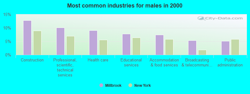
- Construction (12.8%)
- Professional, scientific, technical services (10.2%)
- Health care (9.1%)
- Educational services (7.8%)
- Accommodation & food services (7.5%)
- Broadcasting & telecommunications (5.3%)
- Public administration (5.1%)
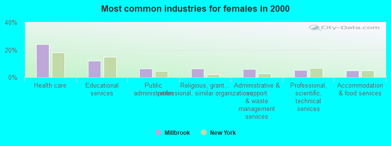
- Health care (24.1%)
- Educational services (12.2%)
- Public administration (6.5%)
- Religious, grantmaking, civic, professional, similar organizations (6.2%)
- Administrative & support & waste management services (5.9%)
- Professional, scientific, technical services (5.4%)
- Accommodation & food services (4.8%)
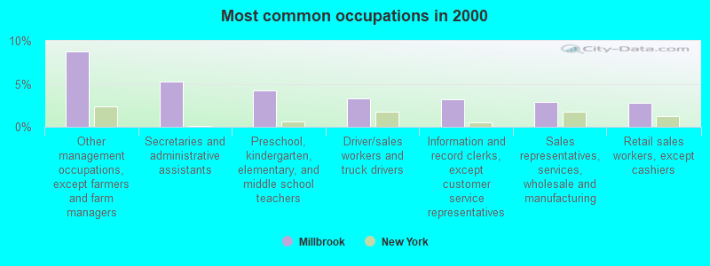
- Other management occupations, except farmers and farm managers (8.8%)
- Secretaries and administrative assistants (5.2%)
- Preschool, kindergarten, elementary, and middle school teachers (4.3%)
- Driver/sales workers and truck drivers (3.3%)
- Information and record clerks, except customer service representatives (3.2%)
- Sales representatives, services, wholesale and manufacturing (2.9%)
- Retail sales workers, except cashiers (2.8%)
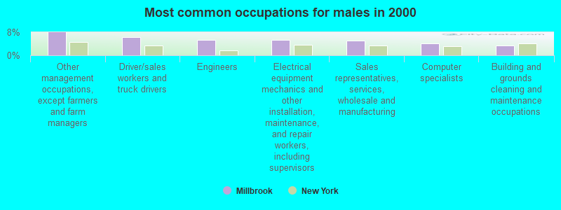
- Other management occupations, except farmers and farm managers (8.0%)
- Driver/sales workers and truck drivers (6.4%)
- Engineers (5.3%)
- Electrical equipment mechanics and other installation, maintenance, and repair workers, including supervisors (5.3%)
- Sales representatives, services, wholesale and manufacturing (5.1%)
- Computer specialists (4.0%)
- Building and grounds cleaning and maintenance occupations (3.5%)
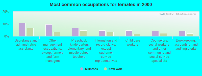
- Secretaries and administrative assistants (10.8%)
- Other management occupations, except farmers and farm managers (9.6%)
- Preschool, kindergarten, elementary, and middle school teachers (6.5%)
- Information and record clerks, except customer service representatives (4.8%)
- Child care workers (4.8%)
- Counselors, social workers, and other community and social service specialists (4.2%)
- Bookkeeping, accounting, and auditing clerks (4.2%)
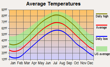
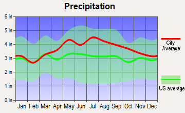
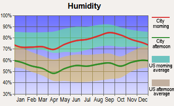
Average climate in Millbrook, New York
Based on data reported by over 4,000 weather stations
|
|

(lower is better)
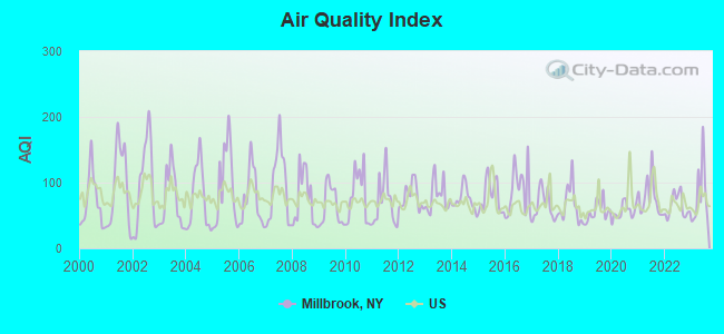
Air Quality Index (AQI) level in 2023 was 82.0. This is about average.
| City: | 82.0 |
| U.S.: | 72.6 |
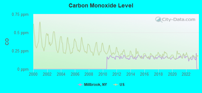
Carbon Monoxide (CO) [ppm] level in 2022 was 0.149. This is significantly better than average. Closest monitor was 13.8 miles away from the city center.
| City: | 0.149 |
| U.S.: | 0.251 |
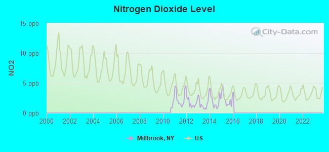
Nitrogen Dioxide (NO2) [ppb] level in 2015 was 2.27. This is significantly better than average. Closest monitor was 2.5 miles away from the city center.
| City: | 2.27 |
| U.S.: | 5.11 |
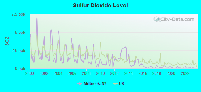
Sulfur Dioxide (SO2) [ppb] level in 2022 was 0.109. This is significantly better than average. Closest monitor was 2.5 miles away from the city center.
| City: | 0.109 |
| U.S.: | 1.515 |
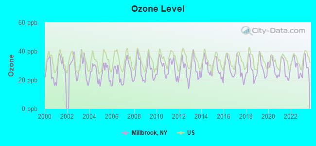
Ozone [ppb] level in 2023 was 30.1. This is about average. Closest monitor was 2.5 miles away from the city center.
| City: | 30.1 |
| U.S.: | 33.3 |
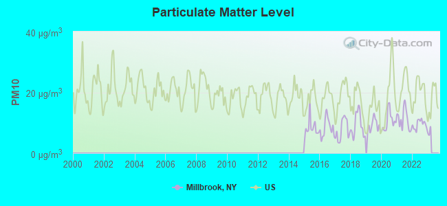
Particulate Matter (PM10) [µg/m3] level in 2022 was 9.49. This is significantly better than average. Closest monitor was 20.5 miles away from the city center.
| City: | 9.49 |
| U.S.: | 19.21 |
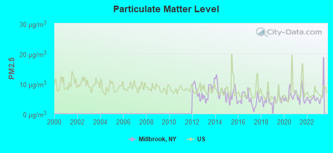
Particulate Matter (PM2.5) [µg/m3] level in 2022 was 4.86. This is significantly better than average. Closest monitor was 13.1 miles away from the city center.
| City: | 4.86 |
| U.S.: | 8.11 |
Tornado activity:
Millbrook-area historical tornado activity is above New York state average. It is 26% smaller than the overall U.S. average.
On 5/29/1995, a category F4 (max. wind speeds 207-260 mph) tornado 31.6 miles away from the Millbrook village center killed 3 people and injured 24 people and caused between $5,000,000 and $50,000,000 in damages.
On 8/28/1973, a category F4 tornado 37.1 miles away from the village center killed 4 people and injured 36 people and caused between $5,000,000 and $50,000,000 in damages.
Earthquake activity:
Millbrook-area historical earthquake activity is significantly above New York state average. It is 68% smaller than the overall U.S. average.On 10/7/1983 at 10:18:46, a magnitude 5.3 (5.1 MB, 5.3 LG, 5.1 ML, Class: Moderate, Intensity: VI - VII) earthquake occurred 153.4 miles away from Millbrook center
On 4/20/2002 at 10:50:47, a magnitude 5.3 (5.3 ML, Depth: 3.0 mi) earthquake occurred 188.5 miles away from Millbrook center
On 4/20/2002 at 10:50:47, a magnitude 5.2 (5.2 MB, 4.2 MS, 5.2 MW, 5.0 MW) earthquake occurred 186.7 miles away from the city center
On 8/23/2011 at 17:51:04, a magnitude 5.8 (5.8 MW, Depth: 3.7 mi) earthquake occurred 350.2 miles away from the city center
On 1/19/1982 at 00:14:42, a magnitude 4.7 (4.5 MB, 4.7 MD, 4.5 LG, Class: Light, Intensity: IV - V) earthquake occurred 159.3 miles away from the city center
On 1/16/1994 at 01:49:16, a magnitude 4.6 (4.6 MB, 4.6 LG, Depth: 3.1 mi) earthquake occurred 158.5 miles away from Millbrook center
Magnitude types: regional Lg-wave magnitude (LG), body-wave magnitude (MB), duration magnitude (MD), local magnitude (ML), surface-wave magnitude (MS), moment magnitude (MW)
Natural disasters:
The number of natural disasters in Dutchess County (19) is greater than the US average (15).Major Disasters (Presidential) Declared: 12
Emergencies Declared: 6
Causes of natural disasters: Storms: 5, Floods: 4, Hurricanes: 4, Blizzards: 2, Snowstorms: 2, Winter Storms: 2, Power Outage: 1, Water Shortage: 1, Other: 3 (Note: some incidents may be assigned to more than one category).
Hospitals and medical centers in Millbrook:
- CARDINAL HAYES HOME FOR CHILDREN, INC (NORTH AVE PO BOX CHHC)
- DUTCHESS COUNTY HLTH CLOSED (OAK SUMMIT ROAD)
Other hospitals and medical centers near Millbrook:
- LIFESPIRE, INC (Hospital, about 3 miles away; WOODSIDE, NY)
- NEW HORIZONS RESOURCES, INC. (Hospital, about 5 miles away; PLEASANT VALLEY, NY)
- TACONIC DDSO (Hospital, about 7 miles away; WASSAIC, NY)
- CARDINAL HAYES HOME FOR CHILDREN, INC (Hospital, about 8 miles away; PLEASANT VALLEY, NY)
- CARDINAL HAYES HOME FOR CHILDREN, INC (Hospital, about 8 miles away; SALT POINT, NY)
- LUTHERAN CENTER AT POUGHKEEPSIE INC (Nursing Home, about 9 miles away; POUGHKEEPSIE, NY)
- VICTORY LAKE NURSING CENTER (Nursing Home, about 9 miles away; HYDE PARK, NY)
Airports and heliports located in Millbrook:
- Sky Acres Airport (44N) (Runways: 1, Itinerant Ops: 24,000, Local Ops: 24,000, Military Ops: 300)
- Johnson Landing Strip Airport (11NY) (Runways: 1)
- Lightning Tree Farm Heliport (4NK7)
- State Police Troop K Heliport (7NY5)
Amtrak stations near Millbrook:
- 14 miles: POUGHKEEPSIE (41 MAIN ST.) . Services: partially wheelchair accessible, enclosed waiting area, public restrooms, public payphones, snack bar, paid short-term parking, paid long-term parking, call for car rental service, taxi stand, public transit connection.
- 17 miles: RHINECLIFF-KINGSTON (RHINECLIFF, HUTTON & CHARLES STS.) . Services: ticket office, partially wheelchair accessible, enclosed waiting area, public restrooms, public payphones, vending machines, free short-term parking, free long-term parking, call for car rental service, taxi stand.
Colleges/universities with over 2000 students nearest to Millbrook:
- Dutchess Community College (about 12 miles; Poughkeepsie, NY; Full-time enrollment: 6,554)
- Vassar College (about 13 miles; Poughkeepsie, NY; FT enrollment: 2,469)
- Culinary Institute of America (about 13 miles; Hyde Park, NY; FT enrollment: 3,869)
- Marist College (about 14 miles; Poughkeepsie, NY; FT enrollment: 5,536)
- Bard College (about 20 miles; Annandale-On-Hudson, NY; FT enrollment: 3,137)
- State University of New York at New Paltz (about 21 miles; New Paltz, NY; FT enrollment: 7,319)
- Ulster County Community College (about 24 miles; Stone Ridge, NY; FT enrollment: 2,207)
Public high school in Millbrook:
- MILLBROOK HIGH SCHOOL (Students: 401, Location: 70 CHURCH ST, Grades: 9-12)
Private high school in Millbrook:
- MILLBROOK SCHOOL (Students: 270, Location: 131 MILLBROOK SCHOOL RD, Grades: 9-12)
Public elementary/middle schools in Millbrook:
- MILLBROOK MIDDLE SCHOOL (Students: 288, Location: 43 ALDEN PL, Grades: 6-8)
- ALDEN PLACE ELEMENTARY SCHOOL (Students: 280, Location: 41 ALDEN PL, Grades: 3-5)
- ELM DRIVE ELEMENTARY SCHOOL (Students: 245, Location: 12 ELM DR, Grades: KG-2)
Private elementary/middle schools in Millbrook:
- ST JOSEPH SCHOOL (Students: 147, Location: 25 ST JOSEPH DR, Grades: PK-8)
- DUTCHESS DAY SCHOOL (Students: 133, Location: 415 ROUTE 343, Grades: PK-8)
Points of interest:
Notable locations in Millbrook: Millbrook Golf Course (A), Halcyon Hall (B), Washington Town Hall (C), Hayes Memorial Library (D), Millbrook Free Library (E), Millbrook Village Town Hall (F), Millbrook Fire Department (G). Display/hide their locations on the map
Churches in Millbrook include: Saint Joseph's Roman Catholic Church (A), Lyall Memorial Federated Church (B), Grace Episcopal Church (C), Church Alliance of Millbrook (D). Display/hide their locations on the map
Cemetery: Nine Partners Cemetery (1). Display/hide its location on the map
Lake: Dieterich Pond (A). Display/hide its location on the map
Streams, rivers, and creeks: Mill Brook (A). Display/hide its location on the map
Hotel: Cottonwood Motel (7 Fowler Road).
Courts: Washington Town - Justice Court (Reservoir Drive), Millbrook Village - Justice Court (Merritt Avenue).
Drinking water stations with addresses in Millbrook and their reported violations in the past:
CHELSEA COVE HOMES (Population served: 1,440, Groundwater):Past monitoring violations:MILLBROOK VINEYARDS (Address: 26 WING ROAD , Population served: 27, Groundwater):
- 38 regular monitoring violations
Past health violations:MILLBROOK TRAINING CENTER (Population served: 25, Groundwater):
- MCL, Acute (TCR) - In AUG-2012, Contaminant: Coliform. Follow-up actions: St Boil Water Order (SEP-04-2012), St Formal NOV issued (SEP-04-2012), St Compliance achieved (OCT-10-2012)
Past health violations:EXPRESS MART ROUTE 44 (Address: 3820 ROUTE 44 , Population served: 25, Groundwater):
- MCL, Acute (TCR) - In DEC-2013, Contaminant: Coliform. Follow-up actions: St Boil Water Order (DEC-16-2013), St Formal NOV issued (DEC-16-2013), St Compliance achieved (JAN-10-2014)
Past health violations:Past monitoring violations:
- MCL, Acute (TCR) - In SEP-2006, Contaminant: Coliform. Follow-up actions: St Boil Water Order (SEP-01-2006), St Formal NOV issued (SEP-01-2006), St Intentional no-action (OCT-12-2006), St Compliance achieved (JUN-01-2009)
- 218 regular monitoring violations
| This village: | 2.1 people |
| New York: | 2.6 people |
| This village: | 56.0% |
| Whole state: | 63.5% |
| This village: | 5.4% |
| Whole state: | 6.8% |
Likely homosexual households (counted as self-reported same-sex unmarried-partner households)
- Lesbian couples: 0.6% of all households
- Gay men: 0.1% of all households
3 people in other noninstitutional facilities in 2010
7 people in homes for the mentally retarded in 2000
Banks with branches in Millbrook (2011 data):
- Bank of Millbrook: Bank Of Millbrook at 3263 Franklin Avenue, branch established on 1891/05/18. Info updated 2011/01/13: Bank assets: $184.6 mil, Deposits: $160.7 mil, local headquarters, positive income, 4 total offices, Holding Company: Millbrook Bank System, Inc.
| Here: | 10.5 |
| New York average: | 13.9 |
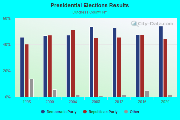
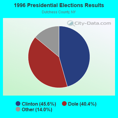
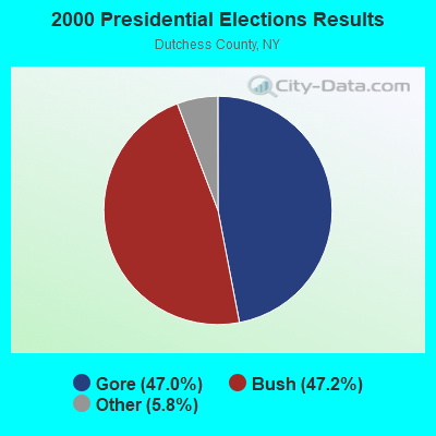
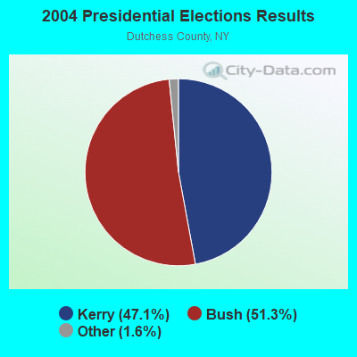
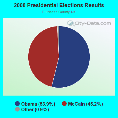
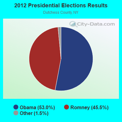
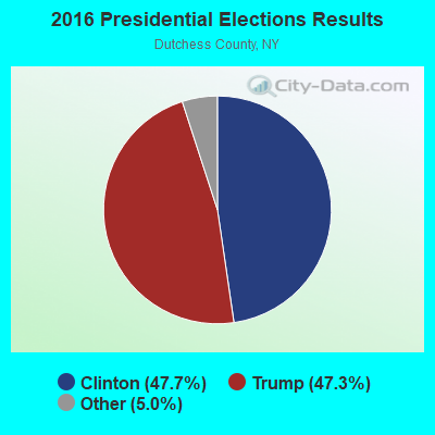

Graphs represent county-level data. Detailed 2008 Election Results
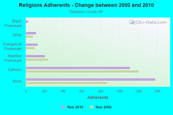
Religion statistics for Millbrook, NY (based on Dutchess County data)
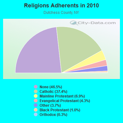
| Religion | Adherents | Congregations |
|---|---|---|
| Catholic | 111,112 | 22 |
| Mainline Protestant | 20,556 | 87 |
| Evangelical Protestant | 12,799 | 69 |
| Other | 10,970 | 28 |
| Black Protestant | 2,898 | 11 |
| Orthodox | 854 | 5 |
| None | 138,299 | - |
Food Environment Statistics:
| This county: | 3.42 / 10,000 pop. |
| New York: | 4.13 / 10,000 pop. |
| Here: | 0.10 / 10,000 pop. |
| New York: | 0.06 / 10,000 pop. |
| Here: | 1.16 / 10,000 pop. |
| New York: | 0.92 / 10,000 pop. |
| This county: | 2.63 / 10,000 pop. |
| New York: | 1.68 / 10,000 pop. |
| Dutchess County: | 10.33 / 10,000 pop. |
| State: | 8.82 / 10,000 pop. |
| Dutchess County: | 8.1% |
| New York: | 8.2% |
| This county: | 24.4% |
| New York: | 23.8% |
| Dutchess County: | 13.4% |
| New York: | 15.6% |
Health and Nutrition:
| Here: | 50.7% |
| State: | 50.1% |
| This city: | 46.8% |
| New York: | 48.1% |
| Millbrook: | 28.2 |
| New York: | 28.5 |
| Here: | 22.4% |
| State: | 20.3% |
| This city: | 9.5% |
| State: | 11.1% |
| Here: | 6.9 |
| State: | 6.8 |
| Millbrook: | 34.0% |
| New York: | 33.4% |
| Here: | 54.9% |
| New York: | 56.5% |
| Millbrook: | 76.3% |
| State: | 80.2% |
More about Health and Nutrition of Millbrook, NY Residents
| Local government employment and payroll (March 2022) | |||||
| Function | Full-time employees | Monthly full-time payroll | Average yearly full-time wage | Part-time employees | Monthly part-time payroll |
|---|---|---|---|---|---|
| Streets and Highways | 3 | $21,627 | $86,508 | 0 | $0 |
| Other Government Administration | 2 | $10,622 | $63,732 | 9 | $5,796 |
| Police Protection - Officers | 0 | $0 | 6 | $15,688 | |
| Totals for Government | 5 | $32,249 | $77,398 | 15 | $21,484 |
Millbrook government finances - Expenditure in 2017 (per resident):
- Construction - Water Utilities: $12,000 ($8.26)
- Current Operations - Regular Highways: $319,000 ($219.70)
Health - Other: $258,000 ($177.69)
General - Other: $244,000 ($168.04)
Sewerage: $242,000 ($166.67)
Water Utilities: $217,000 ($149.45)
Local Fire Protection: $136,000 ($93.66)
Police Protection: $85,000 ($58.54)
Financial Administration: $82,000 ($56.47)
Central Staff Services: $46,000 ($31.68)
General Public Buildings: $34,000 ($23.42)
Judicial and Legal Services: $24,000 ($16.53)
Protective Inspection and Regulation - Other: $11,000 ($7.58)
Solid Waste Management: $2,000 ($1.38)
- General - Interest on Debt: $42,000 ($28.93)
- Intergovernmental to Local - Other - Financial Administration: $5,000 ($3.44)
- Other Capital Outlay - Regular Highways: $168,000 ($115.70)
Water Utilities: $29,000 ($19.97)
Local Fire Protection: $23,000 ($15.84)
Police Protection: $19,000 ($13.09)
General - Other: $2,000 ($1.38)
Sewerage: $2,000 ($1.38)
- Total Salaries and Wages: $382,000 ($263.09)
- Water Utilities - Interest on Debt: $1,000 ($0.69)
Millbrook government finances - Revenue in 2017 (per resident):
- Charges - Sewerage: $264,000 ($181.82)
- Local Intergovernmental - Other: $433,000 ($298.21)
General Local Government Support: $56,000 ($38.57)
- Miscellaneous - Rents: $68,000 ($46.83)
General Revenue - Other: $51,000 ($35.12)
Special Assessments: $30,000 ($20.66)
Interest Earnings: $22,000 ($15.15)
Donations From Private Sources: $4,000 ($2.75)
Fines and Forfeits: $1,000 ($0.69)
- Revenue - Water Utilities: $268,000 ($184.57)
- State Intergovernmental - General Local Government Support: $9,000 ($6.20)
Other: $4,000 ($2.75)
- Tax - Property: $905,000 ($623.28)
Public Utilities Sales: $93,000 ($64.05)
Other License: $13,000 ($8.95)
Millbrook government finances - Debt in 2017 (per resident):
- Long Term Debt - Outstanding Unspecified Public Purpose: $1,168,000 ($804.41)
Beginning Outstanding - Unspecified Public Purpose: $716,000 ($493.11)
Issue, Unspecified Public Purpose: $500,000 ($344.35)
Retired Unspecified Public Purpose: $48,000 ($33.06)
- Short Term Debt Outstanding - Beginning: $321,000 ($221.07)
End of Fiscal Year: $301,000 ($207.30)
Millbrook government finances - Cash and Securities in 2017 (per resident):
- Bond Funds - Cash and Securities: $425,000 ($292.70)
- Other Funds - Cash and Securities: $1,649,000 ($1135.67)
Businesses in Millbrook, NY
- Chevrolet: 1
- UPS: 1
Strongest AM radio stations in Millbrook:
- WEOK (1390 AM; 5 kW; POUGHKEEPSIE, NY)
- WNNZ (640 AM; 50 kW; WESTFIELD, MA; Owner: CLEAR CHANNEL BROADCASTING LICENSES, INC.)
- WTIC (1080 AM; 50 kW; HARTFORD, CT; Owner: INFINITY RADIO OPERATIONS INC.)
- WGHQ (920 AM; 5 kW; KINGSTON, NY; Owner: CLEVELAND RADIO LICENSES, LLC)
- WFAN (660 AM; 50 kW; NEW YORK, NY; Owner: INFINITY BROADCASTING OPERATIONS, INC.)
- WMCA (570 AM; 50 kW; NEW YORK, NY; Owner: SALEM MEDIA OF NEW YORK, LLC)
- WABC (770 AM; 50 kW; NEW YORK, NY; Owner: WABC-AM RADIO, INC.)
- WCBS (880 AM; 50 kW; NEW YORK, NY; Owner: INFINITY BROADCASTING OPERATIONS, INC.)
- WOR (710 AM; 50 kW; NEW YORK, NY; Owner: BUCKLEY BROADCASTING CORPORATION)
- WGY (810 AM; 50 kW; SCHENECTADY, NY; Owner: CLEAR CHANNEL BROADCASTING LICENSES, INC.)
- WGNY (1220 AM; 10 kW; NEWBURGH, NY; Owner: SUNRISE BROADCASTING LLC)
- WKZE (1020 AM; daytime; 2 kW; SHARON, CT; Owner: JOHNSON DEVELOPMENT, INC.)
- WINS (1010 AM; 50 kW; NEW YORK, NY; Owner: INFINITY BROADCASTING OPERATIONS, INC.)
Strongest FM radio stations in Millbrook:
- WRNQ (92.1 FM; POUGHKEEPSIE, NY; Owner: CLEAR CHANNEL BROADCASTING LICENSES, INC.)
- WQQQ (103.3 FM; SHARON, CT; Owner: THE RIDGEFIELD BROADCASTING CORPORATION)
- WPDH (101.5 FM; POUGHKEEPSIE, NY; Owner: CUMULUS LICENSING CORP.)
- W206AW (89.1 FM; PAWLING, NY; Owner: SOUND OF LIFE, INC.)
- WFNP (88.7 FM; ROSENDALE, NY; Owner: STATE UNIVERSITY OF NEW YORK)
- WRHV (88.7 FM; POUGHKEEPSIE, NY; Owner: WMHT EDUCATIONAL TELECOMMUNICATIONS)
- WCZX (97.7 FM; HYDE PARK, NY; Owner: CUMULUS LICENSING CORP.)
- WKZE-FM (98.1 FM; SALISBURY, CT; Owner: JOHNSON DEVELOPMENT, INC.)
- WRRB (96.9 FM; ARLINGTON, NY; Owner: CUMULUS LICENSING CORP.)
- WBWZ (93.3 FM; NEW PALTZ, NY; Owner: CLEVELAND RADIO LICENSES, LLC)
- WRWD-FM (107.3 FM; HIGHLAND, NY; Owner: CLEVELAND RADIO LICENSES, LLC)
- W292CM (106.3 FM; POUGHKEEPSIE, NY; Owner: JOHN KATONAH)
- WSPK (104.7 FM; POUGHKEEPSIE, NY; Owner: 6 JOHNSON ROAD LICENSES, INC.)
- WAMK (90.9 FM; KINGSTON, NY; Owner: W A M C)
- WFGB (89.7 FM; KINGSTON, NY; Owner: SOUND OF LIFE, INC.)
- WFKP (99.3 FM; ELLENVILLE, NY; Owner: CLEAR CHANNEL BROADCASTING LICENSES, INC.)
- WBPM (94.3 FM; KINGSTON, NY; Owner: CONCORD MEDIA GROUP, INC.)
- WDBY (105.5 FM; PATTERSON, NY; Owner: CUMULUS LICENSING CORP.)
- W218AV (91.5 FM; WARREN, CT; Owner: MONROE BOARD OF EDUCATION)
- WAMQ (105.1 FM; GREAT BARRINGTON, MA; Owner: WAMC)
TV broadcast stations around Millbrook:
- WTBY (Channel 54; POUGHKEEPSIE, NY; Owner: TRINITY BROADCASTING OF NEW YORK, INC.)
- WTIC-TV (Channel 61; HARTFORD, CT; Owner: TRIBUNE TELEVISION COMPANY)
- W11BJ (Channel 11; HARTFORD, CT; Owner: COMMUNICATIONS SITE MANAGEMENT LLC)
- WTXX (Channel 20; WATERBURY, CT; Owner: WTXX INC.)
- WVIT (Channel 30; NEW BRITAIN, CT; Owner: OUTLET BROADCASTING, INC)
- WUVN (Channel 18; HARTFORD, CT; Owner: ENTRAVISION HOLDINGS, LLC)
- WEDH (Channel 24; HARTFORD, CT; Owner: CONNECTICUT PUBLIC BROADCASTING, INC.)
- WRNN-TV (Channel 62; KINGSTON, NY; Owner: WRNN-TV ASSOCIATES LIMITED PARTNERSHIP)
- Millbrook, New York
- Fatal accident count30
- Vehicles involved in fatal accidents42
- Fatal accidents involving drunk persons:5
- Fatalities30
- Persons involved in fatal accidents58
- Pedestrians involved in fatal accidents3
- New York average
- Fatal accident count24695
- Vehicles involved in fatal accidents36500
- Fatal accidents involving drunk persons6248
- Fatalities26609
- Persons involved in fatal accidents59537
- Pedestrians involved in fatal accidents6175
- National Bridge Inventory (NBI) Statistics
- 2Number of bridges
- 10ft / 2.9mTotal length
- $3,669,000Total costs
- 4,164Total average daily traffic
- 243Total average daily truck traffic
- 5,829Total future (year 2038) average daily traffic
FCC Registered Antenna Towers:
2- R. Allen Smith, 1/4 Mile South Of Millbrook Reservoir (Lat: 42.619389 Lon: -75.365694), Type: 54.8, Overall height: 54.8 m, Registrant: County Of Chenango, Mbeck301@adelphia.Net, , Norwi-ch, Phone: (607) 337-1862
- R. Allen Smith, 1/4 Mile South Of Millbrook Reservoir (Lat: 42.619389 Lon: -75.365694), Type: 54.8, Overall height: 54.8 m, Registrant: County Of Chenango, Mbeck301@adelphia.Net, , Norwi-ch, Phone: (607) 337-1862
FCC Registered Broadcast Land Mobile Towers:
6- Chestnut Ridge Rd S Hammond Rd (Lat: 41.749250 Lon: -73.627361), Call Sign: KZQ566,
Assigned Frequencies: 154.695 MHz, 155.505 MHz, 155.565 MHz, Grant Date: 01/15/2021, Expiration Date: 03/11/2031, Registrant: New York State Police, 1220 Washington Ave, Bldg 22, Albany, NY 12226-2252, Phone: (518) 457-9466, Fax: (518) 457-5676, Email:
- Off Rt 82 To Camby Rd To Flint Rd (Lat: 41.728972 Lon: -73.660139), Structure height: 15 m, Call Sign: WNVZ207, Licensee ID: L00064154,
Assigned Frequencies: 154.625 MHz, Grant Date: 04/10/1996, Expiration Date: 04/15/2001, Cancellation Date: 06/17/2001, Registrant: Millbrook Meadows, Flint Rd, Millbrook, NY 12545, Phone: (914) 677-8550
- Lat: 41.776389 Lon: -73.701111, Call Sign: WPYH532,
Assigned Frequencies: 461.612 MHz, Grant Date: 08/12/2003, Expiration Date: 08/12/2013, Cancellation Date: 10/12/2013, Certifier: Anthony W Frenzel, Registrant: Radio Licensing Services, 4700 Se International Way, Milwaukie, OR 97222, Phone: (503) 794-3787, Fax: (503) 794-3759
- 131 Millbrook School Road (Lat: 41.846250 Lon: -73.618278), Type: Bant, Structure height: 14 m, Overall height: 17 m, Call Sign: WQRT416,
Assigned Frequencies: 462.750 MHz, Grant Date: 07/23/2013, Expiration Date: 07/23/2023, Cancellation Date: 09/23/2023, Certifier: Robert W Connolly, Registrant: Visiplex, Inc., 1287 North Barclay Boulevard, Buffalo Grove, IL 60089, Phone: (847) 229-0250, Fax: (847) 229-0259, Email:
- Lat: 41.791333 Lon: -73.597250, Call Sign: WRBL704,
Assigned Frequencies: 451.337 MHz, 451.412 MHz, 456.337 MHz, 456.387 MHz, 456.412 MHz, Grant Date: 04/23/2018, Expiration Date: 04/23/2028, Certifier: Michael Marsal, Registrant: Diversified Electronics, 309 C Agnew, Forest Park, GA 30298, Phone: (404) 391-7148, Email:
- Lat: 41.856556 Lon: -73.620111, Call Sign: WREQ483,
Assigned Frequencies: 464.375 MHz, 469.375 MHz, Grant Date: 11/28/2019, Expiration Date: 11/28/2029, Certifier: Alan Tousignant, Registrant: New York Communications Co. Inc., 53 W. Cedar St., Poughkeepsie, NY 12601, Phone: (845) 471-5520, Fax: (845) 471-5593, Email:
FCC Registered Microwave Towers:
3- MILLBROOK, Chestnut Ridge (Lat: 41.750083 Lon: -73.628500), Type: Tower, Structure height: 45.7 m, Call Sign: WQNG707,
Assigned Frequencies: 11325.0 MHz, 5945.20 MHz, 5974.85 MHz, 11325.0 MHz, 5945.20 MHz, 5974.85 MHz, 11325.0 MHz, 5945.20 MHz, 5974.85 MHz, 11325.0 MHz... (+4 more), Grant Date: 01/09/2021, Expiration Date: 02/01/2031, Certifier: Richard M Lacouette, Registrant: Nycomco, 53 West Cedar Street, Poughkeepsie, NY 12601, Phone: (845) 471-5520, Fax: (845) 471-5593, Email:
- AL33XC435, 19 Haight Ave. (Lat: 41.790806 Lon: -73.691833), Type: Tank, Structure height: 27.4 m, Overall height: 30.5 m, Call Sign: WQQP557, Licensee ID: L01744207,
Assigned Frequencies: 11225.0 MHz, 11225.0 MHz, 11225.0 MHz, 11265.0 MHz, 11265.0 MHz, 11265.0 MHz, Grant Date: 02/07/2013, Expiration Date: 02/07/2023, Cancellation Date: 02/02/2023, Certifier: David Werblow, Registrant: Sprint Spectrum LLC
- CHESTNUT RDG, 12 Hammond Hill Road (Lat: 41.750056 Lon: -73.628528), Type: Mtower, Structure height: 45.7 m, Overall height: 46.9 m, Call Sign: WQRS388,
Assigned Frequencies: 11095.0 MHz, Grant Date: 06/22/2023, Expiration Date: 07/17/2033, Certifier: John Monday, Registrant: Att&t Services, Inc., 208 S Akard St, 20f, Dallas, TX 75202, Phone: (855) 699-7073, Email:
FCC Registered Amateur Radio Licenses:
22 (See the full list of FCC Registered Amateur Radio Licenses in Millbrook)FAA Registered Aircraft:
4- Aircraft: WACO QCF (Category: Land, Seats: 3, Weight: Up to 12,499 Pounds, Speed: 79 mph), Engine: CONT MOTOR W670 SERIES (250 HP) (Reciprocating)
N-Number: 11478, N11478, N-11478, Serial Number: 3559, Year manufactured: 1932, Airworthiness Date: 05/07/1970, Certificate Issue Date: 09/14/2001
Registrant (Individual): Daniel J Taylor, 895 Chestnut Ridge Rd, Millbrook, NY 12545 - Aircraft: PIPER J-3C (Category: Land, Seats: 2, Weight: Up to 12,499 Pounds, Speed: 54 mph), Engine: CONT MOTOR A&C75 SERIES (75 HP) (Reciprocating)
N-Number: 70371, N70371, N-70371, Serial Number: 17355, Year manufactured: 1946, Airworthiness Date: 07/22/1955, Certificate Issue Date: 06/25/2004
Registrant (Individual): Daniel J Taylor, 895 Chestnut Ridge Rd, Millbrook, NY 12545 - Aircraft: ENSTROM 280FX (Category: Land, Seats: 3, Weight: Up to 12,499 Pounds), Engine: LYCOMING HIO-360-F1AD (190 HP) (Reciprocating)
N-Number: 776HC, N776HC, N-776HC, Serial Number: 2127, Year manufactured: 2007, Airworthiness Date: 01/02/2007, Certificate Issue Date: 05/20/2009
Registrant (LLC): Cyclic Aviation LLC, 89 Killearn Rd, Millbrook, NY 12545 - Aircraft: ECLIPSE AVIATION CORP EA500 (Category: Land, Engines: 2, Seats: 6, Weight: Up to 12,499 Pounds), Engine: P&W CANADA PW610F-A (950 Pounds of Thrust) (Turbo-fan)
N-Number: 568EA, N568EA, N-568EA, Serial Number: 000168, Year manufactured: 2008, Airworthiness Date: 04/18/2008, Certificate Issue Date: 06/16/2008
Registrant (Corporation): Transport Partners LLC, Po Box 1179, Millbrook, NY 12545
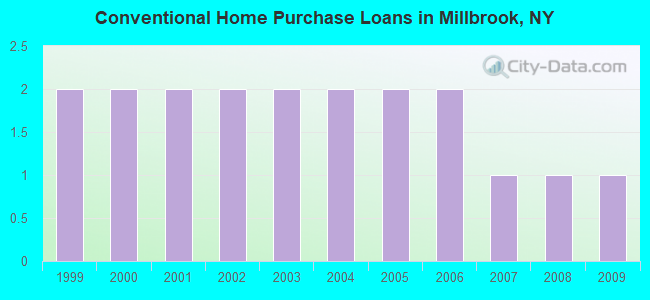
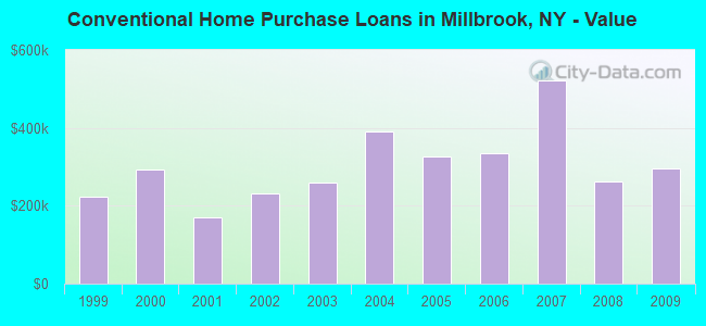
| Home Mortgage Disclosure Act Aggregated Statistics For Year 2009 (Based on 1 partial tract) | ||||
| B) Conventional Home Purchase Loans | C) Refinancings | |||
|---|---|---|---|---|
| Number | Average Value | Number | Average Value | |
| LOANS ORIGINATED | 1 | $294,730 | 2 | $219,650 |
| APPLICATIONS APPROVED, NOT ACCEPTED | 0 | $0 | 0 | $0 |
| APPLICATIONS DENIED | 0 | $0 | 1 | $492,270 |
| APPLICATIONS WITHDRAWN | 0 | $0 | 1 | $273,470 |
| FILES CLOSED FOR INCOMPLETENESS | 0 | $0 | 0 | $0 |
Detailed HMDA statistics for the following Tracts: 2000.00
2002 - 2018 National Fire Incident Reporting System (NFIRS) incidents
- Fire incident types reported to NFIRS in Millbrook, NY
- 43868.8%Structure Fires
- 13921.8%Outside Fires
- 538.3%Mobile Property/Vehicle Fires
- 71.1%Other
 According to the data from the years 2002 - 2018 the average number of fires per year is 37. The highest number of fire incidents - 57 took place in 2015, and the least - 7 in 2010. The data has a declining trend.
 When looking into fire subcategories, the most reports belonged to: Structure Fires (68.8%), and Outside Fires (21.8%).
| Most common first names in Millbrook, NY among deceased individuals | ||
| Name | Count | Lived (average) |
|---|---|---|
| Mary | 74 | 82.1 years |
| John | 57 | 76.9 years |
| William | 49 | 77.4 years |
| Anna | 33 | 82.9 years |
| Helen | 32 | 83.0 years |
| Margaret | 32 | 85.0 years |
| Robert | 28 | 72.0 years |
| James | 27 | 75.0 years |
| George | 26 | 76.9 years |
| Elizabeth | 25 | 80.3 years |
| Most common last names in Millbrook, NY among deceased individuals | ||
| Last name | Count | Lived (average) |
|---|---|---|
| Smith | 14 | 74.6 years |
| Johnson | 11 | 83.8 years |
| Wing | 11 | 77.1 years |
| Ciferri | 10 | 85.3 years |
| Rotunno | 8 | 81.8 years |
| Kelly | 8 | 67.7 years |
| Briggs | 8 | 85.2 years |
| Cummings | 7 | 70.9 years |
| Manzi | 7 | 76.4 years |
| Booth | 7 | 71.6 years |
- 65.0%Fuel oil, kerosene, etc.
- 28.5%Electricity
- 4.2%Bottled, tank, or LP gas
- 2.3%Utility gas
- 56.6%Fuel oil, kerosene, etc.
- 17.7%Bottled, tank, or LP gas
- 13.5%Electricity
- 12.1%Utility gas
Millbrook compared to New York state average:
- Unemployed percentage significantly below state average.
- Black race population percentage significantly below state average.
- Hispanic race population percentage significantly below state average.
- Median age above state average.
- Foreign-born population percentage significantly below state average.

|
|
Total of 104 patent applications in 2008-2024.