Mount Desert, Maine
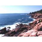
Mount Desert: Rocky shoreline in Acadia National Park
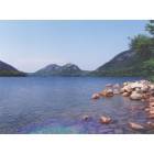
Mount Desert: Jordan Pond in Acadia National Park

Mount Desert: Reflections of fall in Mt. Desert
- add
your
Submit your own pictures of this town and show them to the world
- OSM Map
- Google Map
- MSN Map
Population change since 2000: -2.7%
 |
| Males: 990 | |
| Females: 1,063 |
| Median resident age: | 50.7 years |
| Maine median age: | 43.0 years |
Zip codes: 04660.
| Mount Desert: | $75,420 |
| ME: | $69,543 |
Estimated per capita income in 2022: $52,200 (it was $25,709 in 2000)
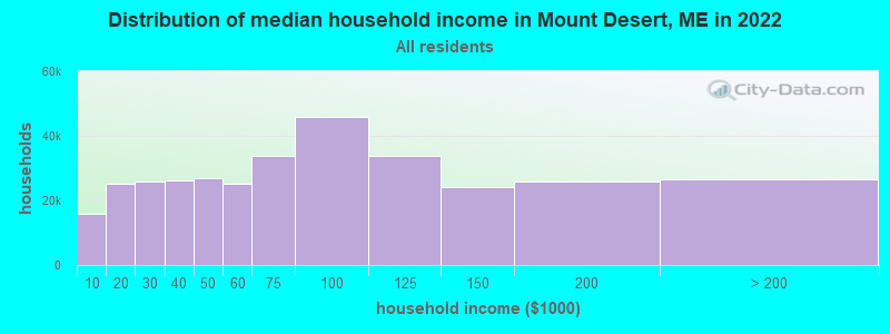
Mount Desert town income, earnings, and wages data
Estimated median house or condo value in 2022: $557,020 (it was $194,500 in 2000)
| Mount Desert: | $557,020 |
| ME: | $290,600 |
Mean prices in 2022: all housing units: $379,336; detached houses: $396,802; townhouses or other attached units: $600,716; in 2-unit structures: $274,479; in 3-to-4-unit structures: $212,346; in 5-or-more-unit structures: $146,369; mobile homes: $158,183; occupied boats, rvs, vans, etc.: $16,454
Detailed information about poverty and poor residents in Mount Desert, ME


- 1,99997.4%White alone
- 180.9%Hispanic
- 140.7%Asian alone
- 140.7%Two or more races
- 50.2%Black alone
- 30.1%American Indian alone
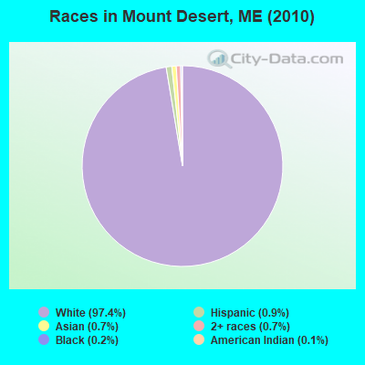
Races in Mount Desert detailed stats: ancestries, foreign born residents, place of birth
 Recent articles from our blog. Our writers, many of them Ph.D. graduates or candidates, create easy-to-read articles on a wide variety of topics.
Ancestries: English (26.2%), Irish (13.6%), German (10.8%), United States (9.1%), French (6.8%), Scotch-Irish (5.7%).
Current Local Time: EST time zone
Incorporated on 02/17/1789
Land area: 36.9 square miles.
Population density: 56 people per square mile (very low).
58 residents are foreign born (1.4% North America, 1.1% Europe).
| This town: | 2.8% |
| Maine: | 2.9% |
| Mount Desert town: | 0.6% ($1,216) |
| Maine: | 1.5% ($1,417) |
Nearest city with pop. 50,000+: Portland, ME  (107.4 miles , pop. 64,249).
Nearest city with pop. 200,000+: Boston, MA (196.8 miles , pop. 589,141).
Nearest city with pop. 1,000,000+: Bronx, NY (371.5 miles , pop. 1,332,650).
Nearest cities:
), ), Latitude: 44.33 N, Longitude: 68.32 W
Area code commonly used in this area: 207
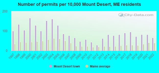
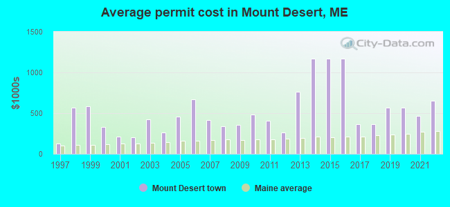
Single-family new house construction building permits:
- 2022: 14 buildings, average cost: $653,000
- 2021: 17 buildings, average cost: $469,600
- 2020: 17 buildings, average cost: $567,100
- 2019: 15 buildings, average cost: $567,100
- 2018: 20 buildings, average cost: $367,000
- 2017: 19 buildings, average cost: $367,000
- 2016: 17 buildings, average cost: $1,166,600
- 2015: 16 buildings, average cost: $1,166,600
- 2014: 17 buildings, average cost: $1,166,600
- 2013: 13 buildings, average cost: $763,700
- 2012: 6 buildings, average cost: $259,300
- 2011: 9 buildings, average cost: $402,800
- 2010: 12 buildings, average cost: $482,700
- 2009: 10 buildings, average cost: $357,100
- 2008: 14 buildings, average cost: $341,700
- 2007: 16 buildings, average cost: $418,600
- 2006: 18 buildings, average cost: $672,000
- 2005: 27 buildings, average cost: $460,200
- 2004: 34 buildings, average cost: $260,300
- 2003: 32 buildings, average cost: $420,300
- 2002: 21 buildings, average cost: $205,400
- 2001: 27 buildings, average cost: $209,000
- 2000: 35 buildings, average cost: $331,200
- 1999: 22 buildings, average cost: $587,700
- 1998: 28 buildings, average cost: $566,000
- 1997: 21 buildings, average cost: $128,800
| Here: | 4.7% |
| Maine: | 3.4% |

- Construction (12.3%)
- Educational services (11.5%)
- Professional, scientific, technical services (10.0%)
- Health care (6.6%)
- Accommodation & food services (6.3%)
- Religious, grantmaking, civic, professional, similar organizations (4.2%)
- Agriculture, forestry, fishing & hunting (3.8%)
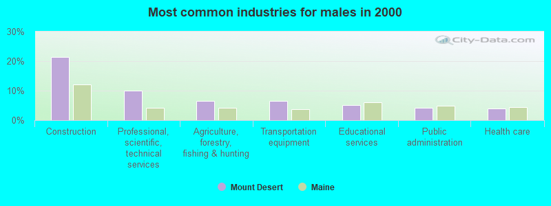
- Construction (21.5%)
- Professional, scientific, technical services (9.9%)
- Agriculture, forestry, fishing & hunting (6.5%)
- Transportation equipment (6.5%)
- Educational services (5.0%)
- Public administration (4.3%)
- Health care (3.9%)
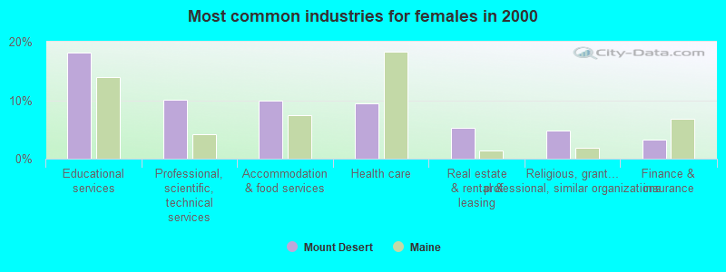
- Educational services (18.1%)
- Professional, scientific, technical services (10.0%)
- Accommodation & food services (9.8%)
- Health care (9.5%)
- Real estate & rental & leasing (5.2%)
- Religious, grantmaking, civic, professional, similar organizations (4.8%)
- Finance & insurance (3.3%)

- Other management occupations, except farmers and farm managers (8.2%)
- Other sales and related occupations, including supervisors (6.7%)
- Secretaries and administrative assistants (5.4%)
- Building and grounds cleaning and maintenance occupations (4.3%)
- Carpenters (3.1%)
- Other office and administrative support workers, including supervisors (2.8%)
- Art and design workers (2.8%)
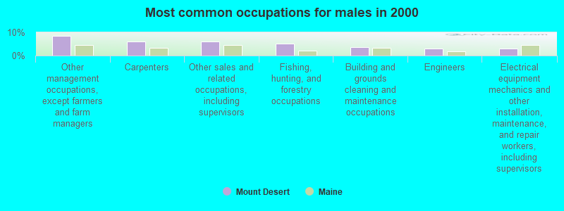
- Other management occupations, except farmers and farm managers (8.4%)
- Carpenters (6.2%)
- Other sales and related occupations, including supervisors (6.0%)
- Fishing, hunting, and forestry occupations (5.0%)
- Building and grounds cleaning and maintenance occupations (3.5%)
- Engineers (3.0%)
- Electrical equipment mechanics and other installation, maintenance, and repair workers, including supervisors (3.0%)

- Secretaries and administrative assistants (11.0%)
- Other management occupations, except farmers and farm managers (7.9%)
- Other sales and related occupations, including supervisors (7.5%)
- Building and grounds cleaning and maintenance occupations (5.0%)
- Other office and administrative support workers, including supervisors (4.1%)
- Art and design workers (3.9%)
- Preschool, kindergarten, elementary, and middle school teachers (3.9%)
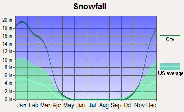
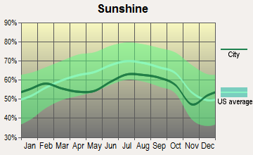
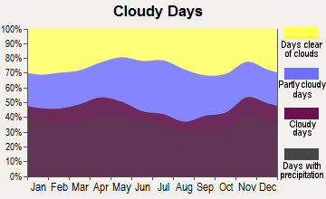
Average climate in Mount Desert, Maine
Based on data reported by over 4,000 weather stations


(lower is better)
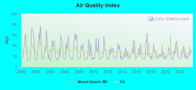
Air Quality Index (AQI) level in 2023 was 61.9. This is about average.
| City: | 61.9 |
| U.S.: | 72.6 |
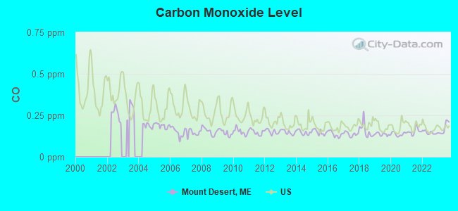
Carbon Monoxide (CO) [ppm] level in 2023 was 0.172. This is significantly better than average. Closest monitor was 4.3 miles away from the city center.
| City: | 0.172 |
| U.S.: | 0.251 |
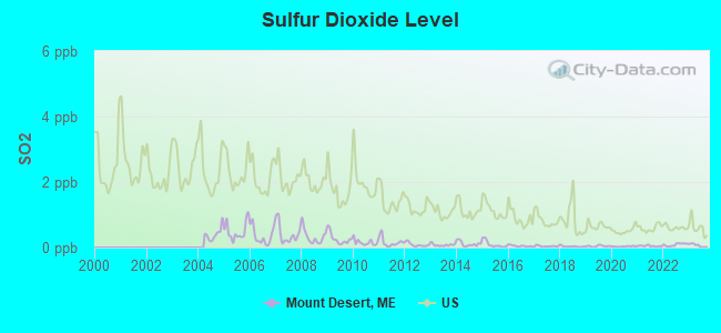
Sulfur Dioxide (SO2) [ppb] level in 2023 was 0.0636. This is significantly better than average. Closest monitor was 4.1 miles away from the city center.
| City: | 0.0636 |
| U.S.: | 1.5147 |
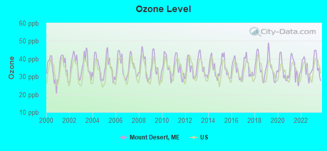
Ozone [ppb] level in 2023 was 36.9. This is about average. Closest monitor was 3.8 miles away from the city center.
| City: | 36.9 |
| U.S.: | 33.3 |
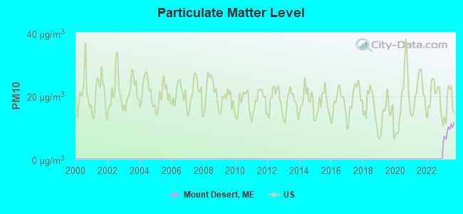
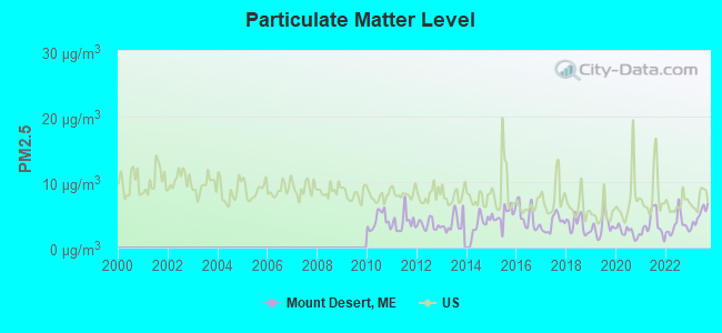
Particulate Matter (PM2.5) [µg/m3] level in 2023 was 4.90. This is significantly better than average. Closest monitor was 4.3 miles away from the city center.
| City: | 4.90 |
| U.S.: | 8.11 |
Earthquake activity:
Mount Desert-area historical earthquake activity is significantly above Maine state average. It is 80% smaller than the overall U.S. average.On 10/16/2012 at 23:12:25, a magnitude 4.7 (4.7 ML, Depth: 10.0 mi, Class: Light, Intensity: IV - V) earthquake occurred 127.0 miles away from the city center
On 4/20/2002 at 10:50:47, a magnitude 5.3 (5.3 ML, Depth: 3.0 mi, Class: Moderate, Intensity: VI - VII) earthquake occurred 266.0 miles away from Mount Desert center
On 4/20/2002 at 10:50:47, a magnitude 5.2 (5.2 MB, 4.2 MS, 5.2 MW, 5.0 MW) earthquake occurred 267.0 miles away from Mount Desert center
On 1/19/1982 at 00:14:42, a magnitude 4.7 (4.5 MB, 4.7 MD, 4.5 LG) earthquake occurred 173.3 miles away from Mount Desert center
On 10/7/1983 at 10:18:46, a magnitude 5.3 (5.1 MB, 5.3 LG, 5.1 ML) earthquake occurred 300.1 miles away from the city center
On 10/3/2006 at 00:07:38, a magnitude 3.7 (3.7 MD, Depth: 6.2 mi, Class: Light, Intensity: II - III) earthquake occurred 8.8 miles away from the city center
Magnitude types: regional Lg-wave magnitude (LG), body-wave magnitude (MB), duration magnitude (MD), local magnitude (ML), surface-wave magnitude (MS), moment magnitude (MW)
Natural disasters:
The number of natural disasters in Hancock County (18) is near the US average (15).Major Disasters (Presidential) Declared: 11
Emergencies Declared: 6
Causes of natural disasters: Floods: 9, Storms: 8, Snows: 5, Blizzard: 1, Heavy Rain: 1, Hurricane: 1, Ice Storm: 1, Landslide: 1, Snowfall: 1, Wind: 1, Winter Storm: 1, Other: 2 (Note: some incidents may be assigned to more than one category).
Hospitals and medical centers near Mount Desert:
- SONOGEE ESTATES (Nursing Home, about 7 miles away; BAR HARBOR, ME)
- SONOGEE REHABILITATION AND LIVING CENTER (Nursing Home, about 7 miles away; BAR HARBOR, ME)
- MOUNT DESERT ISLAND HOSPITAL Critical Access Hospitals (about 7 miles away; BAR HARBOR, ME)
- COURTLAND REHAB AND LIVING CENTER (Nursing Home, about 16 miles away; ELLSWORTH, ME)
- BIRCHWOOD LIVING CENTER (Hospital, about 16 miles away; ELLSWORTH, ME)
- COLLIER'S REHAB AND NURSING CTR (Nursing Home, about 16 miles away; ELLSWORTH, ME)
Colleges/universities with over 2000 students nearest to Mount Desert:
- Husson University (about 42 miles; Bangor, ME; Full-time enrollment: 2,421)
- University of Maine (about 43 miles; Orono, ME; FT enrollment: 8,931)
- University of Maine at Augusta (about 74 miles; Augusta, ME; FT enrollment: 3,204)
- University of Maine at Farmington (about 94 miles; Farmington, ME; FT enrollment: 2,036)
- Southern Maine Community College (about 107 miles; South Portland, ME; FT enrollment: 4,666)
- University of Southern Maine (about 108 miles; Portland, ME; FT enrollment: 6,647)
- Saint Joseph's College of Maine (about 114 miles; Standish, ME; FT enrollment: 2,010)
Public elementary/middle school in Mount Desert:
- MT DESERT ELEMENTARY SCHOOL (Location: 8 JOY RD, Grades: KG-8)
Points of interest:
Notable locations in Mount Desert: Wildwood Stables (A), Wildwood Farm (B), Somes Sound View Campground (C), Seal Harbor Yacht Club (D), Seal Harbor Town Wharf (E), Prettymarsh Picnic Area (F), Northeast Harbor Marina (G), Northeast Harbor Golf Course (H), Mount Desert Yacht Yard (I), Mount Desert Town Wharf (J), Mount Desert Municipal Pier (K), Mount Desert Campground (L), Clifton Dock (M), Asticou Terrace Dock (N), Asticou Landing (O), Ikes Landing (P), Blackwoods Campground (Q), Sound (R), Desert Fire Department Station 3 (S), Desert Fire Department Station 2 (T). Display/hide their locations on the map
Churches in Mount Desert include: Saint James Church (A), Saint Marys by the Sea Church (B), Union Church (C), Saint Judes Church (D), Union Church United Church of Christ (E), Acadia Friends Meeting House (F), First Light Assembly of God Church (G), Saint Ignatius of Loyola Roman Catholic Church (H), Seal Harbor Congregational Church (I). Display/hide their locations on the map
Cemeteries: Pretty Marsh Cemetery (1), Brookside Cemetery (2), Kimball Cemetery (3), Forest Hill Cemetery (4). Display/hide their locations on the map
Lakes, reservoirs, and swamps: Little Echo Lake (A), Little Round Pond (B), Sargent Mountain Pond (C), Duck Pond (D), Goose Marsh Pond (E), Hodgdon Pond (F), Long Pond (G), Ripple Pond (H). Display/hide their locations on the map
Streams, rivers, and creeks: Hodgdon Brook (A), Sargent Brook (B), Little Harbor Brook (C), Stanley Brook (D), Hunters Brook (E), Man of War Brook (F), Jordan Stream (G), Duck Pond Brook (H), Kitteredge Brook (I). Display/hide their locations on the map
Parks in Mount Desert include: Thuya Garden (1), Somesville Historic District (2), Asticou Terraces (3), Asticou Azalea Garden (4), Acadia National Park (5), Champlain Monument (6). Display/hide their locations on the map
Beaches: Echo Lake Beach (A), Hunters Beach (B). Display/hide their locations on the map
Tourist attractions: Mount Desert Island Historical Society - Museum (2 Oak Hill Road) (1), Mount Desert Island Historical Society - OFC (Museums; 373 Sound Drive) (2), National Park Canoe & Kayak Rentals (Tours & Charters; Ponds End) (3). Display/hide their approximate locations on the map
Birthplace of: Charles H. Fernald - Entomologist.
Drinking water stations with addresses in Mount Desert and their reported violations in the past:
MOUNT DESERT CAMPGROUND (Population served: 375, Groundwater):Past monitoring violations:ABELS LOBSTER POUND (Population served: 240, Groundwater):
- 2 routine major monitoring violations
Past monitoring violations:SOMES SOUND VIEW CAMPGROUND (Population served: 150, Groundwater):
- One routine major monitoring violation
Past health violations:CAMP BEECH CLIFF-SOUTH SYSTEM (Population served: 139, Groundwater):Past monitoring violations:
- MCL, Monthly (TCR) - In JUN-2005, Contaminant: Coliform. Follow-up actions: St Public Notif requested (JUN-13-2005), St Violation/Reminder Notice (JUN-13-2005), St Compliance achieved (OCT-15-2007), St Intentional no-action (AUG-10-2011)
- Monitoring, Repeat Major (TCR) - In JUL-2006, Contaminant: Coliform (TCR). Follow-up actions: St Public Notif requested (SEP-14-2006), St Violation/Reminder Notice (SEP-14-2006), St Compliance achieved (OCT-15-2007), St Intentional no-action (SEP-16-2011)
- 13 routine major monitoring violations
- 5 regular monitoring violations
Past health violations:MSAD 76 SWANS ISLAND SCHOOL (Population served: 33, Groundwater):Past monitoring violations:
- MCL, Monthly (TCR) - In JUL-2013, Contaminant: Coliform. Follow-up actions: St Public Notif requested (JUL-24-2013), St Formal NOV issued (JUL-24-2013), St Public Notif received (AUG-13-2013)
- MCL, Monthly (TCR) - In APR-2007, Contaminant: Coliform. Follow-up actions: St Public Notif requested (MAY-07-2007), St Violation/Reminder Notice (MAY-07-2007), St Compliance achieved (MAY-23-2007), St Public Notif received (MAY-30-2007)
- MCL, Monthly (TCR) - In MAY-2005, Contaminant: Coliform. Follow-up actions: St Public Notif requested (MAY-27-2005), St Violation/Reminder Notice (MAY-27-2005), St Public Notif received (2 times from AUG-15-2006 to AUG-15-2006), St Compliance achieved (JAN-19-2007)
- Monitoring, Repeat Major (TCR) - In SEP-2005, Contaminant: Coliform (TCR). Follow-up actions: St Public Notif requested (OCT-19-2005), St Violation/Reminder Notice (OCT-19-2005), St Public Notif received (2 times from AUG-15-2006 to AUG-15-2006), St Compliance achieved (JAN-19-2007)
- Monitoring, Repeat Major (TCR) - In JUN-2005, Contaminant: Coliform (TCR). Follow-up actions: St Public Notif requested (JUL-21-2005), St Violation/Reminder Notice (JUL-21-2005), St Public Notif received (2 times from AUG-15-2006 to AUG-15-2006), St Compliance achieved (JAN-19-2007)
- 3 routine major monitoring violations
Past monitoring violations:
- Follow-up Or Routine LCR Tap M/R - In JAN-11-2005, Contaminant: Lead and Copper Rule. Follow-up actions: St Public Notif requested (FEB-23-2005), St Violation/Reminder Notice (FEB-23-2005), St Public Notif received (MAR-14-2005), St Compliance achieved (JUL-29-2005)
- 2 routine major monitoring violations
- 66 regular monitoring violations
Drinking water stations with addresses in Mount Desert that have no violations reported:
- MSU 98 MT DESERT ISLAND HIGH SCHOOL (Population served: 725, Primary Water Source Type: Groundwater)
- APPALACHIAN MOUNTAIN CLUB-ECHO LAKE (Population served: 108, Primary Water Source Type: Groundwater)
| This town: | 2.1 people |
| Maine: | 2.3 people |
| This town: | 59.6% |
| Whole state: | 62.9% |
| This town: | 8.1% |
| Whole state: | 9.4% |
Likely homosexual households (counted as self-reported same-sex unmarried-partner households)
- Lesbian couples: 0.5% of all households
- Gay men: 0.3% of all households
| This town: | 5.1% |
| Whole state: | 10.9% |
| This town: | 3.3% |
| Whole state: | 4.1% |
Banks with branches in Mount Desert (2011 data):
- Bar Harbor Bank & Trust: Somesville Branch at 1055 Main Street, branch established on 2006/03/22. Info updated 2007/04/24: Bank assets: $1,166.8 mil, Deposits: $723.6 mil, headquarters in Bar Harbor, ME, positive income, Commercial Lending Specialization, 12 total offices, Holding Company: Bar Harbor Bankshares
For population 15 years and over in Mount Desert:
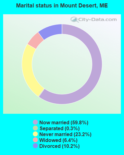
- Never married: 23.2%
- Now married: 59.8%
- Separated: 0.3%
- Widowed: 6.4%
- Divorced: 10.2%
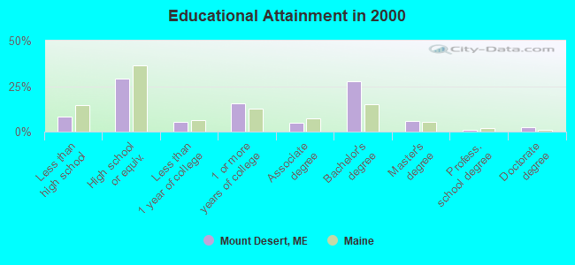
For population 25 years and over in Mount Desert:
- High school or higher: 91.8%
- Bachelor's degree or higher: 36.9%
- Graduate or professional degree: 9.2%
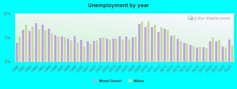
- Unemployed: 3.5%
- Mean travel time to work (commute): 18.1 minutes
| Here: | 9.5 |
| Maine average: | 11.2 |


Graphs represent county-level data. Detailed 2008 Election Results
Religion statistics for Mount Desert, ME (based on Hancock County data)


| Religion | Adherents | Congregations |
|---|---|---|
| Mainline Protestant | 4,691 | 58 |
| Catholic | 2,523 | 9 |
| Evangelical Protestant | 1,288 | 23 |
| Other | 820 | 11 |
| None | 45,096 | - |
Food Environment Statistics:
| This county: | 6.01 / 10,000 pop. |
| Maine: | 2.80 / 10,000 pop. |
| Hancock County: | 1.69 / 10,000 pop. |
| Maine: | 2.20 / 10,000 pop. |
| Here: | 4.89 / 10,000 pop. |
| State: | 5.75 / 10,000 pop. |
| Here: | 21.61 / 10,000 pop. |
| State: | 11.02 / 10,000 pop. |
| This county: | 7.4% |
| Maine: | 8.2% |
| Hancock County: | 25.4% |
| Maine: | 25.0% |
| Businesses in Mount Desert, ME | ||||
| Name | Count | Name | Count | |
|---|---|---|---|---|
| Circle K | 1 | Subway | 1 | |
| FedEx | 1 | UPS | 1 | |
Strongest AM radio stations in Mount Desert:
- WDEA (1370 AM; 5 kW; ELLSWORTH, ME; Owner: CUMULUS LICENSING CORP.)
- WZON (620 AM; 5 kW; BANGOR, ME; Owner: THE ZONE CORPORATION)
- WABI (910 AM; 5 kW; BANGOR, ME; Owner: CLEAR CHANNEL BROADCASTING LICENSES, INC.)
- WRKO (680 AM; 50 kW; BOSTON, MA; Owner: ENTERCOM BOSTON LICENSE, LLC)
- WSKW (1160 AM; 10 kW; SKOWHEGAN, ME; Owner: MOUNTAIN WIRELESS, INCORPORATED)
- WEEI (850 AM; 50 kW; BOSTON, MA; Owner: ENTERCOM BOSTON LICENSE, LLC)
- WBZ (1030 AM; 50 kW; BOSTON, MA; Owner: INFINITY BROADCASTING OPERATIONS, INC.)
- WCRN (830 AM; 50 kW; WORCESTER, MA; Owner: CARTER BROADCASTING CORPORATION)
- WTME (780 AM; 10 kW; RUMFORD, ME; Owner: MOUNTAIN VALLEY BROADCASTING, INC.)
- WNNZ (640 AM; 50 kW; WESTFIELD, MA; Owner: CLEAR CHANNEL BROADCASTING LICENSES, INC.)
- WKOX (1200 AM; 50 kW; FRAMINGHAM, MA; Owner: CAPSTAR TX LIMITED PARTNERSHIP)
- WALE (990 AM; 50 kW; GREENVILLE, RI; Owner: NORTH AMERICAN BROADCASTING CO., INC.)
- WWZN (1510 AM; 50 kW; BOSTON, MA; Owner: ROSE CITY RADIO CORPORATION)
Strongest FM radio stations in Mount Desert:
- WERU-FM (89.9 FM; BLUE HILL, ME; Owner: SALT POND COMMUNITY B/C COMPANY)
- WNSX (97.7 FM; WINTER HARBOR, ME; Owner: CLEAR CHANNEL BROADCASTING LICENSES, INC.)
- WLKE (99.1 FM; BAR HARBOR, ME; Owner: CLEAR CHANNEL BROADCASTING LICENSES, INC.)
- WWMJ (95.7 FM; ELLSWORTH, ME; Owner: CUMULUS LICENSING CORP.)
- WFZX (101.7 FM; SEARSPORT, ME; Owner: CLEAR CHANNEL BROADCASTING LICENSES, INC.)
- WBQI (107.7 FM; BAR HARBOR, ME; Owner: MARINER BROADCASTING, L.P.)
- WBFB (104.7 FM; BELFAST, ME; Owner: CLEAR CHANNEL BROADCASTING LICENSES, INC.)
- WKIT-FM (100.3 FM; BREWER, ME; Owner: THE ZONE CORPORATION)
- WMEH (90.9 FM; BANGOR, ME; Owner: MAINE PUBLIC BROADCASTING CORPORATION)
- WMEP (90.5 FM; CAMDEN, ME; Owner: MAINE PUBLIC BROADCASTING CORP.)
- WQSS (102.5 FM; CAMDEN, ME; Owner: CLEAR CHANNEL BROADCASTING LICENSES, INC.)
- WEZQ (92.9 FM; BANGOR, ME; Owner: CUMULUS LICENSING CORP.)
- WHCF (88.5 FM; BANGOR, ME; Owner: BANGOR BAPTIST CHURCH)
- WWBX (97.1 FM; BANGOR, ME; Owner: CLEAR CHANNEL BROADCASTING LICENSES, INC.)
- W217BK (91.3 FM; SOUTHWEST HARBOR, ME; Owner: CALVARY CHAPEL OF TWIN FALLS, INC.)

- National Bridge Inventory (NBI) Statistics
- 2Number of bridges
- 7ft / 1.7mTotal length
- 5,591Total average daily traffic
- 279Total average daily truck traffic
- 7,827Total future (year 2036) average daily traffic
FCC Registered Antenna Towers:
10 (See the full list of FCC Registered Antenna Towers in Mount Desert)FCC Registered Maritime Coast & Aviation Ground Towers:
2- Hall Quarry Rd (Lat: 44.341194 Lon: -68.326417), Type: Building, Overall height: 6 m, Call Sign: WQB782, Licensee ID: L00012637,
Assigned Frequencies: 156.425 MHz, 156.800 MHz, 156.450 MHz, Grant Date: 05/04/2005, Expiration Date: 07/20/2015, Cancellation Date: 09/19/2015, Registrant: Donald Chambers, 20 Chambers Lane Hall Quary Rd, Mount Desert, ME 04660
- Bartlett Island (Lat: 44.343972 Lon: -68.438917), Type: Building, Overall height: 8 m, Call Sign: WQZ373,
Assigned Frequencies: 156.450 MHz, 156.800 MHz, Grant Date: 02/21/2023, Expiration Date: 01/20/2033, Registrant: Browns Communications, 162 Bangor Road, Ellsworth, ME 04605, Phone: (207) 667-2254, Email:
FCC Registered Amateur Radio Licenses:
10 (See the full list of FCC Registered Amateur Radio Licenses in Mount Desert)FAA Registered Aircraft:
2- Aircraft: JACOBS DON RV-7A (Category: Land, Seats: 2, Weight: Up to 12,499 Pounds), Engine: CONT MOTOR IO-360 SER (300 HP) (Reciprocating)
N-Number: 298PJ, N298PJ, N-298PJ, Serial Number: 71609, Year manufactured: 2006, Airworthiness Date: 04/29/2006, Certificate Issue Date: 11/19/2020
Registrant (Individual): Jason David Irwin, 16 Pine Ledge Ln, Mount Desert, ME 04660 - Aircraft: CESSNA T182T (Category: Land, Seats: 4, Weight: Up to 12,499 Pounds), Engine: LYCOMING TIO-540-AK1A (235 HP) (Reciprocating)
N-Number: 6197F, N6197F, N-6197F, Serial Number: T18208889, Year manufactured: 2008, Airworthiness Date: 08/19/2008, Certificate Issue Date: 06/01/2020
Registrant (Co-Owned): Robert A Young, Po Box 226, Mount Desert, ME 04660, Other Owners: Mary Anne Young
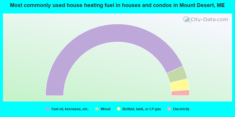
- 86.3%Fuel oil, kerosene, etc.
- 6.0%Wood
- 5.0%Bottled, tank, or LP gas
- 2.6%Electricity
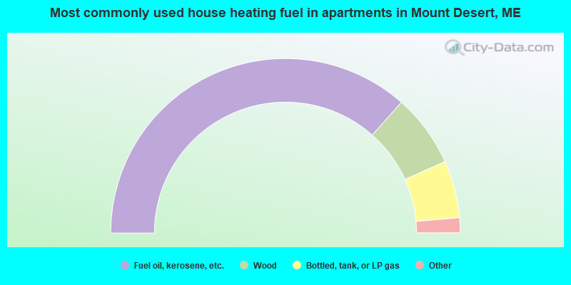
- 73.0%Fuel oil, kerosene, etc.
- 13.5%Wood
- 10.6%Bottled, tank, or LP gas
- 1.8%No fuel used
- 1.1%Utility gas
Mount Desert compared to Maine state average:
- Median house value above state average.
- Unemployed percentage significantly below state average.
- Black race population percentage significantly below state average.
- Hispanic race population percentage below state average.
- Median age above state average.
- Length of stay since moving in significantly above state average.
- Number of rooms per house significantly below state average.
- House age significantly below state average.
- Number of college students below state average.

|
Total of 14 patent applications in 2008-2024.